
Search Constraints
You searched for:
Campus
IUB
Remove constraint Campus: IUB
Type
Image
Remove constraint Type: Image
Publisher
Indiana. Department of Geology and Natural Resources
Remove constraint Publisher: Indiana. Department of Geology and Natural Resources
« Previous |
1 - 50 of 196
|
Next »
Search Results
-
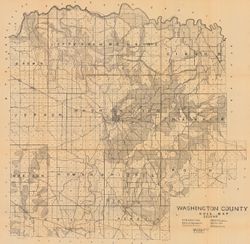
- Subject:
- Geographic Subject: Washington County (Ind.) and Topical Subject: Soils
- Creator:
- Indiana. Department of Geology and Natural Resources
- Publisher:
- Indiana. Department of Geology and Natural Resources
- Date Created:
- 1908
- Identifier:
- VAC3073-M-00603
- Genre:
- Thematic maps
- Geographic Location:
- Coordinates: W0861836 W0855051 N0384700 N0382504
- Related URL:
- Catalog URL: https://iucat.iu.edu/catalog/16096233
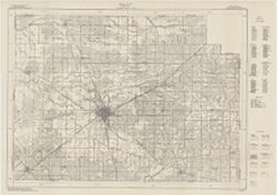
- Abstract:
- Shows railroads, dirt roads, improved roads, school houses, and churches. Detached from: Soil survey of Monroe, Brown, Lawrence, Martin, Orange, Washingto...
- Call Number:
- G4093.W5J3 1907 .I53
- Caption:
- Imprint: [Indianapolis] : [Indiana Department of Geology and Natural Resources], [1908]
- Physical Description:
- Scale: Approximately 1:63,360 and Dimensions: 67 x 68 cm
- Alternate Identifier:
- Title Control Number: a16096233 and Alternate ID: 390726IP
- Persistent URL:
- https://purl.dlib.indiana.edu/iudl/images/VAC3073/VAC3073-M-00603
- Provenance:
- 32nd Annual Report (1907) / Indiana. Department of Geology and Natural Resources.
-
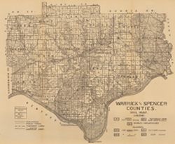
- Subject:
- Geographic Subject: Spencer County (Ind.), Geographic Subject: Warrick County (Ind.), and Topical Subject: Soils
- Creator:
- Shannon, C. W. (Charles William), 1879-1934
- Publisher:
- Indiana. Department of Geology and Natural Resources
- Date Created:
- 1910
- Identifier:
- VAC3073-M-00654
- Genre:
- Thematic maps
- Geographic Location:
- Coordinates: W0872823 W0864559 N0381446 N0374653
- Related URL:
- Catalog URL: https://iucat.iu.edu/catalog/16123910
- Abstract:
- Shows public roads and railroads. Detached from: A soil survey of Vanderburgh, Gibson, and Pike, and parts of Warrick and Spencer counties / Chas. W. Shan...
- Call Number:
- G4093.S5J3 1909 .S5
- Caption:
- Imprint: [Indianapolis] : [Indiana Department of Geology and Natural Resources], [1910]
- Physical Description:
- Dimensions: 44 x 52 cm and Scale: Approximately 1:126,720
- Alternate Identifier:
- Title Control Number: a16123910 and Alternate ID: 390726IP
- Persistent URL:
- https://purl.dlib.indiana.edu/iudl/images/VAC3073/VAC3073-M-00654
- Provenance:
- 34th Annual Report (1909) / Indiana. Department of Geology and Natural Resources.
-
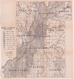
- Subject:
- Geographic Subject: Vigo County (Ind.), Topical Subject: Soils, Topical Subject: Geology, and Topical Subject: Mines and mineral resources
- Creator:
- Shannon, M. E., Shannon, C. W. (Charles William), 1879-1934, and United States. Bureau of Soils
- Publisher:
- Indiana. Department of Geology and Natural Resources
- Date Created:
- 1912
- Identifier:
- VAC3073-M-01092
- Genre:
- Thematic maps
- Geographic Location:
- Coordinates: W0873635 W0871156 N0393629 N0391532
- Related URL:
- Catalog URL: https://iucat.iu.edu/catalog/16131306
- Abstract:
- Shows dirt roads and improved public roads, railroads, school houses, cemeteries, and churches. Detached from: Soil survey of Clay, Knox, Sullivan, and Vi...
- Call Number:
- G4093.V5J3 1911 .S5
- Caption:
- Imprint: [Indianapolis] : [Department of Geology and Natural Resources, Indiana], [1912] [Indianapolis] : [Wm. B. Burford], [1912]
- Physical Description:
- Dimensions: 64 x 59 cm and Scale: Approximately 1:63,360
- Alternate Identifier:
- Title Control Number: a16131306 and Alternate ID: 390726IP
- Persistent URL:
- https://purl.dlib.indiana.edu/iudl/images/VAC3073/VAC3073-M-01092
- Provenance:
- 36th Annual Report (1911) / Indiana. Department of Geology and Natural Resources.
-
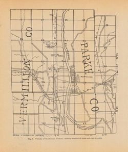
- Subject:
- Geographic Subject: Montezuma (Ind.), Topical Subject: Shale, Topical Subject: Clay industries, Geographic Subject: Vermillion County (Ind.), Topical Subject...
- Creator:
- Blatchley, Raymond S. (Raymond Sillliman)
- Publisher:
- Indiana. Department of Geology and Natural Resources
- Date Created:
- 1905
- Identifier:
- VAC3073-M-00274
- Genre:
- Geological maps
- Geographic Location:
- Coordinates: W0872510 W0872023 N0395020 N0394532
- Related URL:
- Catalog URL: https://iucat.iu.edu/catalog/18282337
- Abstract:
- Shows the location of clay and shale deposits as well as the locations of brick, clay works, and tile companies. At head of title: Fig. 5. "R.S.B. Del.&...
- Call Number:
- G4094.M68H5 1904 .V53
- Caption:
- Imprint: [Indianapolis] : [Wm. B. Burford], [1905] and Imprint: [Indianapolis] : [Indiana Department of Geology and Natural Resources], [1905]
- Physical Description:
- Dimensions: 23 x 19 cm and Scale: Approximately 1:53,000
- Alternate Identifier:
- Alternate ID: 390726IP and Title Control Number: a18282337
- Persistent URL:
- https://purl.dlib.indiana.edu/iudl/images/VAC3073/VAC3073-M-00274
- Provenance:
- 29th Annual Report (1904) / Indiana. Department of Geology and Natural Resources.
-
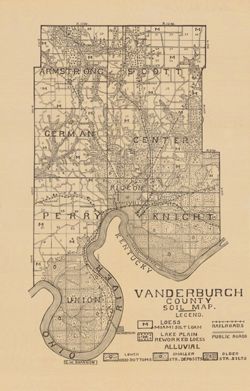
- Subject:
- Topical Subject: Soils and Geographic Subject: Vanderburgh County (Ind.)
- Creator:
- Shannon, C. W. (Charles William), 1879-1934
- Publisher:
- Indiana. Department of Geology and Natural Resources
- Date Created:
- 1910
- Identifier:
- VAC3073-M-00292
- Genre:
- Thematic maps
- Geographic Location:
- Coordinates: W0874202 W0872657 N0381006 N0374932
- Related URL:
- Catalog URL: https://iucat.iu.edu/catalog/16123565
- Abstract:
- Shows railroads and public roads. Detached from: A soil survey of Vanderburgh, Gibson, and Pike, and parts of Warrick and Spencer counties / Chas. W. Shan...
- Call Number:
- G4093.V3J3 1909 .S5
- Caption:
- Imprint: [Indianapolis] : [Indiana Department of Geology and Natural Resources], [1910]
- Physical Description:
- Dimensions: 37 x 24 cm and Scale: Approximately 1:126,720
- Alternate Identifier:
- Alternate ID: 390726IP and Title Control Number: a16123565
- Persistent URL:
- https://purl.dlib.indiana.edu/iudl/images/VAC3073/VAC3073-M-00292
- Provenance:
- 34th Annual Report (1909) / Indiana. Department of Geology and Natural Resources.
-
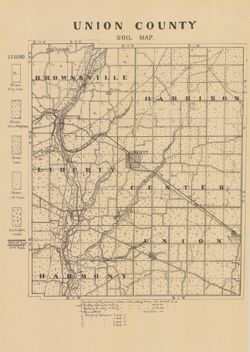
- Subject:
- Topical Subject: Soils and Geographic Subject: Union County (Ind.)
- Creator:
- Indiana. Department of Geology and Natural Resources
- Publisher:
- Indiana. Department of Geology and Natural Resources
- Date Created:
- 1910
- Identifier:
- VAC3073-M-00859
- Genre:
- Thematic maps
- Geographic Location:
- Coordinates: W0850210 W0844851 N0394345 N0393119
- Related URL:
- Catalog URL: https://iucat.iu.edu/catalog/16124317
- Abstract:
- Shows railroads, dirt roads, and gravel roads. Includes notes on general topography. Detached from: A soil survey of Randolph, Wayne, Henry, Rush, Fayette...
- Call Number:
- G4093.U5J3 1909 .I53
- Caption:
- Imprint: [Indianapolis] : [Indiana Department of Geology and Natural Resources], [1910]
- Physical Description:
- Dimensions: 25 x 21 cm and Scale: Approximately 1:95,000
- Alternate Identifier:
- Title Control Number: a16124317 and Alternate ID: 390726IP
- Persistent URL:
- https://purl.dlib.indiana.edu/iudl/images/VAC3073/VAC3073-M-00859
- Provenance:
- 34th Annual Report (1909) / Indiana. Department of Geology and Natural Resources.
-
- Subject:
- Topical Subject: Mines and mineral resources, Topical Subject: Geology, Topical Subject: IGS Annual Reports, Geographic Subject: Perry County (Ind.), and Top...
- Publisher:
- Indiana. Department of Geology and Natural Resources
- Date Created:
- 1898
- Identifier:
- VAC3073-M-00991
- Genre:
- Geological maps and Geological cross-sections
- Geographic Location:
- Coordinates: W0864825 W0863629 N0380227 N0375602
- Related URL:
- Catalog URL: https://iucat.iu.edu/catalog/18349350
- Abstract:
- ncludes index map and 16 stratigraphic columns showing coal measurements. Plate LXVII. "Troy. Tell City." Detached from: Seventh annual report o...
- Call Number:
- G4093.P2H9 1876 .T69
- Caption:
- Imprint: [Indianapolis] : [Sentinel Company, printers], [1876] and Imprint: [Indianapolis] : [Geological Survey of Indiana], [1876]
- Physical Description:
- Scale: Approximately 1:63,360. Vertical scale indeterminable and Dimensions: on sheet 21 x 26 cm
- Alternate Identifier:
- Title Control Number: a18349350 and Alternate ID: 390726IP
- Persistent URL:
- https://purl.dlib.indiana.edu/iudl/images/VAC3073/VAC3073-M-00991
- Provenance:
- 7th Annual Report (1875) / Indiana. Geological Survey.
-
![Township 5 south, range 8 west [Indiana]](https://iiif.uits.iu.edu/iiif/2/df65wb20n%2Ffiles%2F076a45f7-4ea5-41d9-9a65-3d0fbf136b54/full/250,/0/default.jpg)
- Subject:
- Topical Subject: Geology, Stratigraphic, Topical Subject: IGS Annual Reports, Geographic Subject: Warrick County (Ind.), and Topical Subject: Coal reserves
- Publisher:
- Indiana. Department of Geology and Natural Resources
- Date Created:
- 1899
- Identifier:
- VAC3073-M-00913
- Genre:
- Geological cross-sections and Geological maps
- Geographic Location:
- Coordinates: W0872133 W0871442 N0380715 N0380157
- Related URL:
- Catalog URL: https://iucat.iu.edu/catalog/18418184
- Abstract:
- Title from caption. Other title from Bureau of Land Management database: IN T5S R8W. 16 columnar sections showing coal measures and location map for unnamed ...
- Call Number:
- G4093.W4H9 1898 .T6
- Caption:
- Imprint: [Indianapolis] : [Wm. B. Burford], [1899] and Imprint: [Indianapolis] : [Indiana, Dept. of Geology and Natural History], [1899]
- Physical Description:
- Dimensions: 23 x 27 cm and Scale: Approximately 1:63,360
- Alternate Identifier:
- Alternate ID: 390726IP and Title Control Number: a18418184
- Persistent URL:
- https://purl.dlib.indiana.edu/iudl/images/VAC3073/VAC3073-M-00913
- Provenance:
- 23rd Annual Report (1898) / Indiana. Department of Geology and Natural Resources.
-
![Township 2 south, range 7 west [Indiana]](https://iiif.uits.iu.edu/iiif/2/2b88rf889%2Ffiles%2F8503c6af-2a95-4ca4-acde-dcd4736a0d0c/full/250,/0/default.jpg)
- Subject:
- Topical Subject: Coal reserves, Geographic Subject: Pike County (Ind.), Topical Subject: Geology, Stratigraphic, and Topical Subject: IGS Annual Reports
- Publisher:
- Indiana. Department of Geology and Natural Resources
- Date Created:
- 1899
- Identifier:
- VAC3073-M-00614
- Genre:
- Geological cross-sections and Geological maps
- Geographic Location:
- Coordinates: W0871432 W0870735 N0382243 N0381721
- Related URL:
- Catalog URL: http://www.iucat.iu.edu/catalog/18418128
- Abstract:
- Relief shown by profile. Other title from Bureau of Land Management database: IN T2S R7W. 20 columnar sections showing coal measures and location map for unn...
- Call Number:
- G4093.P4H9 1898 .T6
- Caption:
- Imprint: [Indianapolis] : [Wm. B. Burford], [1899] and Imprint: [Indianapolis] : [Indiana, Dept. of Geology and Natural History], [1899]
- Physical Description:
- Dimensions: 23 x 27 cm and Scale: Approximately 1:63,360. Vertical scale not given
- Alternate Identifier:
- Title Control Number: a18418128 and Alternate ID: 390726IP
- Persistent URL:
- https://purl.dlib.indiana.edu/iudl/images/VAC3073/VAC3073-M-00614
- Provenance:
- 23rd Annual Report (1898) / Indiana. Department of Geology and Natural Resources.
-
- Subject:
- Geographic Subject: Indiana, Topical Subject: Precipitation (Meteorology), and Topical Subject: IGS Annual Reports
- Publisher:
- Indiana. Department of Geology and Natural Resources
- Date Created:
- 1911
- Identifier:
- VAC3073-M-00072
- Genre:
- Thematic maps
- Geographic Location:
- Coordinates: W0880500 W0844700 N0414500 N0374600
- Related URL:
- Catalog URL: https://iucat.iu.edu/catalog/18307828
- Abstract:
- 2 maps on one sheet. Shows rainfall over the state of Indiana in inches. "Fig. 2." Detached from: Water power of Indiana / W.M. Tucker. In India...
- Call Number:
- G4091.C88 1909 .T6
- Caption:
- Imprint: [Indianapolis] : [Indiana Department of Geology and Natural Resources], [1911]
- Physical Description:
- Scale: Scale not given. and Dimensions: on sheet 23 x 27 cm
- Alternate Identifier:
- Alternate ID: 390726IP and Title Control Number: a18307828
- Persistent URL:
- https://purl.dlib.indiana.edu/iudl/images/VAC3073/VAC3073-M-00072
- Provenance:
- 35th Annual Report (1910) / Indiana. Department of Geology and Natural Resources.
-
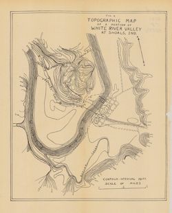
- Subject:
- Topical Subject: IGS Annual Reports, Topical Subject: Rivers, Geographic Subject: White River Valley (Ind.), Geographic Subject: Shoals (Ind.), Topical Subje...
- Publisher:
- Indiana. Department of Geology and Natural Resources
- Date Created:
- 1911
- Identifier:
- VAC3073-M-00393
- Genre:
- Topographic maps
- Geographic Location:
- Coordinates: W0864835 W0864633 N0384050 N0383903
- Related URL:
- Catalog URL: https://iucat.iu.edu/catalog/18418396
- Abstract:
- Relief shown by contours. Contour interval 10 feet. Shows proposed canal routes, proposed dam location, and power house. At head of title: "Fig. 4."...
- Call Number:
- G4093.M5C2 1910 .T6
- Caption:
- Imprint: [Indianapolis] : [Indiana Department of Geology and Natural Resources], [1911] and Imprint: [Indianapolis] : [Wm. B. Burford], [1911]
- Physical Description:
- Scale: Approximately 1:11,750 and Dimensions: 28 x 23 cm
- Alternate Identifier:
- Title Control Number: a18418396 and Alternate ID: 390726IP
- Persistent URL:
- https://purl.dlib.indiana.edu/iudl/images/VAC3073/VAC3073-M-00393
- Provenance:
- 35th Annual Report (1910) / Indiana. Department of Geology and Natural Resources.
-
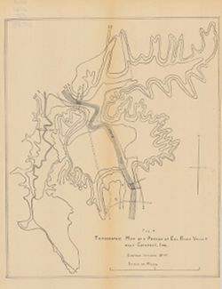
- Subject:
- Geographic Subject: Owen County (Ind.), Geographic Subject: Eel River Valley (Ind. : Valley), Topical Subject: IGS Annual Reports, and Topical Subject: Valleys
- Publisher:
- Indiana. Department of Geology and Natural Resources
- Date Created:
- 1911
- Identifier:
- VAC3073-M-00830
- Genre:
- Topographic maps
- Geographic Location:
- Coordinates: W0865003 W0864726 N0392725 N0392513
- Related URL:
- Catalog URL: https://iucat.iu.edu/catalog/18418393
- Abstract:
- Relief shown by contours. Contour interval 20 feet. Shows upper falls dam and proposed lower falls dams now located within the Cataract Falls State Recreatio...
- Call Number:
- G4092.O8C2 1910 .T6
- Caption:
- Imprint: [Indianapolis] : [Wm. B. Burford], [1911] and Imprint: [Indianapolis] : [Indiana Department of Geology and Natural Resources], [1911]
- Physical Description:
- Scale: Approximately 1:7,650 and Dimensions: 31 x 25 cm
- Alternate Identifier:
- Title Control Number: a18418393 and Alternate ID: 390726IP
- Persistent URL:
- https://purl.dlib.indiana.edu/iudl/images/VAC3073/VAC3073-M-00830
- Provenance:
- 35th Annual Report (1910) / Indiana. Department of Geology and Natural Resources.
-
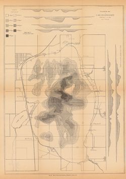
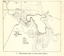
- Subject:
- Geographic Subject: Maxinkuckee, Lake (Ind.), Topical Subject: IGS Annual Reports, Topical Subject: Lakes, Geographic Subject: Marshall County (Ind.), Geogra...
- Creator:
- Scovell, J. T. (Josiah Thomas), 1841-
- Publisher:
- Indiana. Department of Geology and Natural Resources
- Date Created:
- 1901
- Identifier:
- VAC3073-M-00003
- Genre:
- Bathymetric maps and Topographic maps
- Geographic Location:
- Coordinates: W0862605 W0862248 N0411337 N0411052
- Related URL:
- Catalog URL: https://iucat.iu.edu/catalog/18279165
- Abstract:
- Depth shown by isolines, patterning, and profile. In addition to Lake Maxinkuckee, the map shows local sites including Marmont (now Culver), a railroad, mill...
- Call Number:
- G4092.M33 1900 .S36
- Caption:
- Imprint: [Indianapolis] : [Indiana. Department of Geology and Natural Resources], [1901]
- Physical Description:
- Scale: Approximately 1:14,630 and Dimensions: on sheet 44 x 33 cm
- Alternate Identifier:
- Title Control Number: a18279165 and Alternate ID: 390726IP
- Persistent URL:
- https://purl.dlib.indiana.edu/iudl/images/VAC3073/VAC3073-M-00003
- Provenance:
- 25th Annual Report (1900) / Indiana. Department of Geology and Natural Resources.
-
- Subject:
- Topical Subject: Lakes, Geographic Subject: Winona Lake (Ind. : Lake), Geographic Subject: Warsaw (Ind.), and Topical Subject: IGS Annual Reports
- Publisher:
- Indiana. Department of Geology and Natural Resources
- Date Created:
- 1904
- Identifier:
- VAC3073-M-01577
- Genre:
- Topographic maps
- Related URL:
- Catalog URL: new.iucat.iu.edu/catalog/4022271
- Call Number:
- QE109 .A2 1903
- Caption:
- Imprint: Indianapolis : 1904.
- Persistent URL:
- https://purl.dlib.indiana.edu/iudl/images/VAC3073/VAC3073-M-01577
- Provenance:
- 28th Annual Report (1903) / Indiana. Department of Geology and Natural Resources.
-
- Subject:
- Geographic Subject: Indiana and Topical Subject: IGS Annual Reports
- Creator:
- Hesler, R. S.
- Publisher:
- Indiana. Department of Geology and Natural Resources
- Date Created:
- 1913
- Identifier:
- VAC3073-M-01536
- Genre:
- Topographic maps
- Geographic Location:
- Coordinates: W0880500 W0844700 N0414500 N0374600
- Related URL:
- Catalog URL: https://iucat.iu.edu/catalog/18466085
- Abstract:
- Relief shown by choropleth methods. "Note: Data--railroad elevations, Plan--after Leverett." Detached from: Topography of Indiana--Map / Edward ...
- Call Number:
- G4091.C2 1913 .H4
- Caption:
- Imprint: [Indianapolis] : [Indiana Department of Geology and Natural Resources], [1913]
- Physical Description:
- Dimensions: on sheet 73 x 46 cm and Scale: Scale not given.
- Alternate Identifier:
- Alternate ID: 390726IP and Title Control Number: a18466085
- Persistent URL:
- https://purl.dlib.indiana.edu/iudl/images/VAC3073/VAC3073-M-01536
- Provenance:
- 37th Annual Report (1912) / Indiana. Department of Geology and Natural Resources.
-

- Subject:
- Geographic Subject: Indiana, Topical Subject: IGS Annual Reports, and Topical Subject: Geology, Stratigraphic--Ordovician
- Creator:
- Cumings, E. R. (Edgar Roscoe), 1874-1967
- Publisher:
- Indiana. Department of Geology and Natural Resources
- Date Created:
- 1908
- Identifier:
- VAC3073-M-00874
- Genre:
- Geological cross-sections
- Geographic Location:
- Coordinates: W0880500 W0844700 N0414500 N0374600
- Related URL:
- Catalog URL: https://iucat.iu.edu/catalog/18307667
- Abstract:
- 3 sections on one sheet. Title from caption. Shows strategraphic measurements for sections 5.9A, 1.38A, and 1.38B. Detached from: The stratigraphy and pal...
- Call Number:
- G4091.C57 1907 .Z47
- Caption:
- Imprint: [Indianapolis] : [Indiana Department of Geology and Natural Resources], [1908]
- Physical Description:
- Dimensions: 44 x 19 cm
- Alternate Identifier:
- Title Control Number: a18307667 and Alternate ID: 390726IP
- Persistent URL:
- https://purl.dlib.indiana.edu/iudl/images/VAC3073/VAC3073-M-00874
- Provenance:
- 32nd Annual Report (1907) / Indiana. Department of Geology and Natural Resources.
-
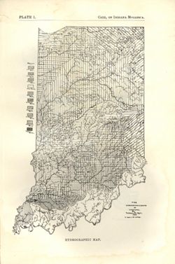
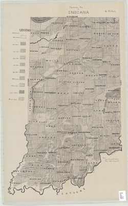
- Subject:
- Topical Subject: Watersheds and Geographic Subject: Indiana
- Creator:
- Call, Richard Ellsworth, 1856-1917
- Publisher:
- Indiana. Department of Geology and Natural Resources
- Date Created:
- 1900
- Identifier:
- VAC3073-M-01572
- Genre:
- Maps
- Geographic Location:
- Coordinates: W0880500 W0844700 N0414500 N0374600
- Related URL:
- Catalog URL: https://iucat.iu.edu/catalog/18418197
- Abstract:
- At foot of map: "Hydrographic map." At head of map: "Plate 1 -- Call, On Indiana mollusca." Detached from: A descriptive illustrated cata...
- Call Number:
- G4091.C315 1896 .C3
- Caption:
- Imprint: [Indianapolis] : [Department of Geology and Natural Resources], [1900] and Imprint: [Indianapolis] : [Wm. B. Burford], [1900]
- Physical Description:
- Dimensions: on sheet 22 x 15 cm and Scale: Approximately 1:1,267,200. 1 inch = 20 miles
- Alternate Identifier:
- Alternate ID: 390726IP and Title Control Number: a18418197
- Persistent URL:
- https://purl.dlib.indiana.edu/iudl/images/VAC3073/VAC3073-M-01572
- Provenance:
- 24th Annual Report (1899) / Indiana. Department of Geology and Natural Resources.
-
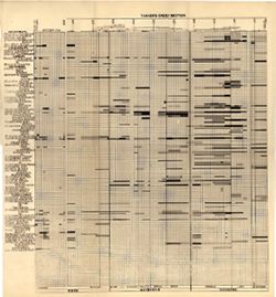
- Subject:
- Topical Subject: Stratigraphic correlation, Topical Subject: Geology, Stratigraphic--Ordovician, Topical Subject: Bilateria, Fossil, Topical Subject: IGS Ann...
- Creator:
- Cumings, E. R. (Edgar Roscoe), 1874-1967 and Galloway, J. J. (Jesse James), 1882-1962
- Publisher:
- Indiana. Department of Geology and Natural Resources
- Date Created:
- 1913
- Identifier:
- VAC3073-M-01183
- Genre:
- Cartographic materials and Graphs
- Geographic Location:
- Coordinates: W0880500 W0844700 N0414500 N0374600
- Related URL:
- Catalog URL: https://iucat.iu.edu/catalog/18416521
- Abstract:
- Sections on one sheet. Title from caption. Diagram showing stratagraphic measurements for bilateria fossils in the Tanner's Creek Formation from the Cinc...
- Call Number:
- G4091.C57 1912 .C8
- Caption:
- Imprint: [Indianapolis] : [Department of Geology and Natural Resources], [1913] and Imprint: [Indianapolis] : [Wm. B. Burford, contractor for state printing ...
- Physical Description:
- Scale: Scale not given. Vertical scale approximately 1:550 and Dimensions: 38 x 41 cm
- Alternate Identifier:
- Title Control Number: a18416521 and Alternate ID: 390726IP
- Persistent URL:
- https://purl.dlib.indiana.edu/iudl/images/VAC3073/VAC3073-M-01183
- Provenance:
- 37th Annual Report (1912) / Indiana. Department of Geology and Natural Resources.
-
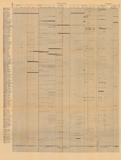
- Subject:
- Geographic Subject: Wayne County (Ind.), Topical Subject: Geology, Topical Subject: Paleontology, Geographic Subject: Tanners Creek (Ind. : Creek), Topical S...
- Creator:
- Cumings, E. R. (Edgar Roscoe), 1874-1967
- Publisher:
- Indiana. Department of Geology and Natural Resources
- Date Created:
- 1908
- Identifier:
- VAC3073-M-00692
- Genre:
- Graphs
- Geographic Location:
- Coordinates: W0845749 W0844849 N0395257 N0390333
- Related URL:
- Catalog URL: https://iucat.iu.edu/catalog/18298805
- Abstract:
- Title derived from captions. Chart showing stratigraphic measurements for paleontology samples collected around Tanner's Creek in Dearborn County and Ric...
- Call Number:
- G4091.C57 1908 .C86
- Caption:
- Imprint: [Indianapolis] : [Indiana Dept. of Geology and Natural Resources], [1908]
- Physical Description:
- Dimensions: 63 x 48 cm
- Alternate Identifier:
- Title Control Number: a18298805 and Alternate ID: 390726IP
- Persistent URL:
- https://purl.dlib.indiana.edu/iudl/images/VAC3073/VAC3073-M-00692
- Provenance:
- 32nd Annual Report (1907) / Indiana. Department of Geology and Natural Resources.
-
- Subject:
- Geographic Subject: Clay County (Ind.), Topical Subject: IGS Annual Reports, Topical Subject: Coal, Topical Subject: Mines and mineral resources, Geographic ...
- Creator:
- Ashley, Geo. H. (George Hall), 1866-1951
- Publisher:
- Indiana. Department of Geology and Natural Resources
- Date Created:
- 1909
- Identifier:
- VAC3073-M-00359
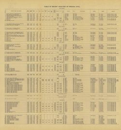
- Genre:
- Tables (Data) and Charts
- Related URL:
- Catalog URL: https://iucat.iu.edu/catalog/4022271
- Abstract:
- Detached from: The coal deposits of Indiana : a supplemental report to the one issued in 1898 / by Beorge H. Ashley. In Indiana Department of Geology and Nat...
- Call Number:
- QE109 .A2 1908 map p144
- Caption:
- Imprint: Indianapolis : 1909
- Physical Description:
- Dimensions: 40 x 38 cm
- Alternate Identifier:
- Title Control Number: 390726IP
- Persistent URL:
- https://purl.dlib.indiana.edu/iudl/images/VAC3073/VAC3073-M-00359
- Provenance:
- 33rd Annual Report (1908) / Indiana. Department of Geology and Natural Resources.
-
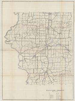
- Subject:
- Topical Subject: Soils, Geographic Subject: Sullivan County (Ind.), Topical Subject: IGS Annual Reports, and Topical Subject: Soil surveys
- Creator:
- Shannon, C. W. (Charles William), 1879-1934 and Shannon, M. E.
- Publisher:
- Indiana. Department of Geology and Natural Resources
- Date Created:
- 1912
- Identifier:
- VAC3073-M-01483
- Genre:
- Thematic maps
- Geographic Location:
- Coordinates: W0873845 W0871422 N0391540 N0385413
- Related URL:
- Catalog URL: https://iucat.iu.edu/catalog/18307850
- Abstract:
- Shows soil types, earth and improved public roads, railroads, schools, cemeteries, churches, and coal mines. Detached from: Soil survey of Clay, Knox, Sul...
- Call Number:
- G4093.S8J3 1911 .S5
- Caption:
- Imprint: [Indianapolis] : [Department of Geology and Natural Resources, Indiana], [1912]
- Physical Description:
- Scale: Approximately 1:63,360 and Dimensions: on sheet 64 x 59 cm
- Alternate Identifier:
- Alternate ID: 390726IP and Title Control Number: a18307850
- Persistent URL:
- https://purl.dlib.indiana.edu/iudl/images/VAC3073/VAC3073-M-01483
- Provenance:
- 36th Annual Report (1911) / Indiana. Department of Geology and Natural Resources.
-
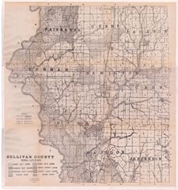
- Subject:
- Geographic Subject: Sullivan County (Ind.) and Topical Subject: Soils
- Creator:
- Shannon, M. E. and Shannon, C. W. (Charles William), 1879-1934
- Publisher:
- Indiana. Department of Geology and Natural Resources
- Date Created:
- 1912
- Identifier:
- VAC3073-M-01095
- Genre:
- Thematic maps
- Geographic Location:
- Coordinates: W0873933 W0871425 N0391534 N0385405
- Related URL:
- Catalog URL: https://iucat.iu.edu/catalog/16137467
- Abstract:
- Shows dirt roads and improved public roads, railroads, schools, cemeteries, churches, and coal mines. Detached from: Soil survey of Clay, Knox, Sullivan, ...
- Call Number:
- G4093.S8J3 1911 .S5
- Caption:
- Imprint: [Indianapolis] : [Department of Geology and Natural Resources, Indiana], [1912] [Indianapolis] : [Wm. B. Burford], [1912]
- Physical Description:
- Scale: Approximately 1:63,360 and Dimensions: 64 x 59 cm
- Alternate Identifier:
- Title Control Number: a16137467 and Alternate ID: 390726IP
- Persistent URL:
- https://purl.dlib.indiana.edu/iudl/images/VAC3073/VAC3073-M-01095
- Provenance:
- 36th Annual Report (1911) / Indiana. Department of Geology and Natural Resources.
-
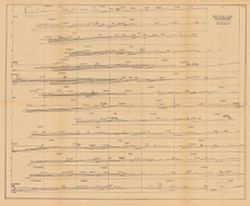
- Subject:
- Topical Subject: Coal, Topical Subject: Geology, Stratigraphic, Topical Subject: IGS Annual Reports, and Geographic Subject: Indiana
- Creator:
- Ashley, Geo. H. (George Hall), 1866-1951
- Publisher:
- Indiana. Department of Geology and Natural Resources
- Date Created:
- 1909
- Identifier:
- VAC3073-M-00650
- Genre:
- Geological cross-sections
- Geographic Location:
- Coordinates: W0880500 W0844700 N0414500 N0374600
- Related URL:
- Catalog URL: https://iucat.iu.edu/catalog/18307698
- Abstract:
- 15 sections on one sheet. Detached from: The coal deposits of Indiana : a supplemental report to the one issued in 1898 / George H. Ashley. In Indiana Dep...
- Call Number:
- QE109 .A2 1908
- Caption:
- Imprint: [Indianapolis] : [Indiana Department of Geology and Natural Resources], [1909]
- Physical Description:
- Dimensions: 44 x 53 cm and Scale: Approximately 1:126,720. 2 miles = 1 inch. Vertical scale approximately 1:12,000. 1,000 feet = 1 inch
- Alternate Identifier:
- Title Control Number: a18307698 and Alternate ID: 390726IP
- Persistent URL:
- https://purl.dlib.indiana.edu/iudl/images/VAC3073/VAC3073-M-00650
- Provenance:
- 33rd Annual Report (1908) / Indiana. Department of Geology and Natural Resources.
-
- Subject:
- Topical Subject: Coal, Topical Subject: IGS Annual Reports, Topical Subject: Geology, Geographic Subject: Indiana, and Topical Subject: Stratigraphic correla...
- Creator:
- Ashley, Geo. H. (George Hall), 1866-1951
- Publisher:
- Indiana. Department of Geology and Natural Resources
- Date Created:
- 1909
- Identifier:
- VAC3073-M-00058
- Genre:
- Geological cross-sections
- Geographic Location:
- Coordinates: W0880500 W0844700 N0414500 N0374600
- Related URL:
- Catalog URL: https://iucat.iu.edu/catalog/18307694
- Abstract:
- Includes approximately 100 stratigraphic columns and correlation lines. Detached from: The coal deposits of Indiana : a supplemental report to the one iss...
- Call Number:
- G4091.H9 1908 .S77
- Caption:
- Imprint: [Indianapolis] : [Indiana Department of Geology and Natural Resources], [1909]
- Physical Description:
- Scale: Horizontal scale not given. Vertical scale approximately 1:960. 1 inch = 80 feet and Dimensions: 40 x 75 cm
- Alternate Identifier:
- Title Control Number: a18307694 and Alternate ID: 390726IP
- Persistent URL:
- https://purl.dlib.indiana.edu/iudl/images/VAC3073/VAC3073-M-00058
- Provenance:
- 33rd Annual Report (1908) / Indiana. Department of Geology and Natural Resources.
-
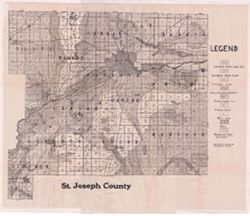
- Subject:
- Geographic Subject: Saint Joseph County (Ind.) and Topical Subject: Soils
- Creator:
- Indiana. Department of Geology and Natural Resources
- Publisher:
- Indiana. Department of Geology and Natural Resources
- Date Created:
- 1912
- Identifier:
- VAC3073-M-01087
- Genre:
- Thematic maps
- Geographic Location:
- Coordinates: W0863136 W0860333 N0414538 N0412558
- Related URL:
- Catalog URL: https://iucat.iu.edu/catalog/16137081
- Abstract:
- Shows dirt roads, improved roads, and railroads. Detached from: Soil survey of St. Joseph County / E.J. Quinn. In Thirty-sixth annual report of Department...
- Call Number:
- G4093.S2J3 1911 .I53
- Caption:
- Imprint: [Indianapolis] : [Department of Geology and Natural Resources], [1912] and Imprint: [Indianapolis] : [Wm. B. Burford], [1912]
- Physical Description:
- Dimensions: 43 x 45 cm, on sheet 46 x 56 cm and Scale: Approximately 1:90,000
- Alternate Identifier:
- Title Control Number: a16137081 and Alternate ID: 390726IP
- Persistent URL:
- https://purl.dlib.indiana.edu/iudl/images/VAC3073/VAC3073-M-01087
- Provenance:
- 36th Annual Report (1911) / Indiana. Department of Geology and Natural Resources.
-
- Subject:
- Topical Subject: Soils and Geographic Subject: Marion County (Ind.)
- Creator:
- Geib, W. J. (Warren Jacob), 1880- and Schroeder, Frank C.
- Publisher:
- Indiana. Department of Geology and Natural Resources
- Date Created:
- 1912
- Identifier:
- VAC3073-M-01090
- Genre:
- Thematic maps
- Geographic Location:
- Coordinates: W0861941 W0855614 N0395538 N0393755
- Related URL:
- Catalog URL: https://iucat.iu.edu/catalog/16151623
- Abstract:
- Detached from: Soil survey of Marion County, Indiana / W.J. Geib and Frank C. Schroeder. In Thirty-sixth annual report of Department of Geology and Natural R...
- Call Number:
- G4093.M3J3 1911 .G4
- Caption:
- Imprint: [Indianapolis] : [Wm. B. Burford], [1912] and Imprint: [Indianapolis] : [Department of Geology and Natural Resources], [1912]
- Physical Description:
- Scale: Approximately 1:63,360 and Dimensions: 53 x 53 cm
- Alternate Identifier:
- Alternate ID: 390726IP and Title Control Number: a16151623
- Persistent URL:
- https://purl.dlib.indiana.edu/iudl/images/VAC3073/VAC3073-M-01090
- Provenance:
- 36th Annual Report (1911) / Indiana. Department of Geology and Natural Resources.
-
- Subject:
- Geographic Subject: Wells County (Ind.), Topical Subject: IGS Annual Reports, and Topical Subject: Soils
- Creator:
- United States. Bureau of Soils, Tharp, W. E. (William Edgar), and Wiley, W. E. (William Emmett), 1894-1967
- Publisher:
- Indiana. Department of Geology and Natural Resources
- Date Created:
- 1916
- Identifier:
- VAC3073-M-01537
- Genre:
- Thematic maps
- Geographic Location:
- Coordinates: W0852656 W0850406 N0405504 N0403400
- Related URL:
- Catalog URL: https://iucat.iu.edu/catalog/16138560
- Abstract:
- "Field Operations, Bureau of Soils, 1915." Detached from: Soil survey of Wells County / W. E. Tharp and W. E. Wiley. In Fortieth annual report o...
- Call Number:
- G4093.W7J3 1915 .T49
- Caption:
- Imprint: [Fort Wayne]: [Fort Wayne Printing Company], [1916] and Imprint: [Indianapolis] : State of Indiana, Department of Geology, [1916]
- Physical Description:
- Dimensions: 58 x 48 cm and Scale: 1:63,360. 1 in. = 1 mile
- Alternate Identifier:
- Title Control Number: a16138560 and Alternate ID: 390726IP
- Persistent URL:
- https://purl.dlib.indiana.edu/iudl/images/VAC3073/VAC3073-M-01537
- Provenance:
- 40th Annual Report (1915) / Indiana. Department of Geology and Natural Resources.
-
- Subject:
- Topical Subject: Soils and Geographic Subject: Grant County (Ind.)
- Creator:
- Hertenstein, Earl, Hurst, Lewis A. (Lewis Alexander), 1874-, Middleton, Philip (Soil surveyor), Watkins, W. I. (William Isaac), 1888-1973, Tharp, W. E. (Will...
- Publisher:
- Indiana. Department of Geology and Natural Resources
- Date Created:
- 1916
- Identifier:
- VAC3073-M-01510
- Genre:
- Thematic maps
- Geographic Location:
- Coordinates: W0855153 W0852639 N0403913 N0402242
- Related URL:
- Catalog URL: https://iucat.iu.edu/catalog/16142796
- Abstract:
- "Field Operations Bureau of Soils, 1915"--Lower margin. Detached from: Soil survey of Grant County, Indiana / L.A. Hurst [and others]. In 40th A...
- Call Number:
- G4093.G6J3 1915 .H88
- Caption:
- Imprint: [Indianapolis] : Indiana Department of Geology, [1916] and Imprint: [Fort Wayne] : [Fort Wayne Printing Company], [1916]
- Physical Description:
- Scale: Approximately 1:63,360. 1 in. = 1 mile and Dimensions: 46 x 53 cm
- Alternate Identifier:
- Title Control Number: a16142796 and Alternate ID: 390726IP
- Persistent URL:
- https://purl.dlib.indiana.edu/iudl/images/VAC3073/VAC3073-M-01510
- Provenance:
- 40th Annual Report (1915) / Indiana. Department of Geology and Natural Resources.
-
- Subject:
- Geographic Subject: Greene County (Ind.) and Topical Subject: Soils
- Creator:
- Tharp, W. E. (William Edgar)
- Publisher:
- Indiana. Department of Geology and Natural Resources
- Date Created:
- 1912
- Identifier:
- VAC3073-M-01159
- Genre:
- Thematic maps
- Geographic Location:
- Coordinates: W0871427 W0864055 N0391018 N0385408
- Related URL:
- Catalog URL: https://iucat.iu.edu/catalog/16151513
- Abstract:
- Detached from: Soil survey of Greene County (1901) / by W. E. Tharp and Charles J. Mann, of the U. S. Bureau of Soils. In Thirty-sixth annual report of Depar...
- Call Number:
- G4093.G7J3 1906 .T5
- Caption:
- Imprint: [Indianapolis] : State of Indiana, Department of Geology, [1912] [Indianapolis] : [Wm. B. Burford], [1912]
- Physical Description:
- Dimensions: 35 x 52 cm and Scale: 1:80,000
- Alternate Identifier:
- Title Control Number: a16151513 and Alternate ID: 390726IP
- Persistent URL:
- https://purl.dlib.indiana.edu/iudl/images/VAC3073/VAC3073-M-01159
- Provenance:
- 36th Annual Report (1911) / Indiana. Department of Geology and Natural Resources.
-
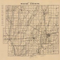
- Subject:
- Topical Subject: Soils and Geographic Subject: Wayne County (Ind.)
- Creator:
- Indiana. Department of Geology and Natural Resources
- Publisher:
- Indiana. Department of Geology and Natural Resources
- Date Created:
- 1910
- Identifier:
- VAC3073-M-00002
- Genre:
- Thematic maps
- Geographic Location:
- Coordinates: W0851316 W0844838 N0400022 N0394253
- Related URL:
- Catalog URL: https://iucat.iu.edu/catalog/16124401
- Abstract:
- Shows roads and railroads. Includes notes on general topography. Detached from: A soil survey of Randolph, Wayne, Henry, Rush, Fayette, Union and Franklin...
- Call Number:
- G4093.W6J3 1909 .I53
- Caption:
- Imprint: [Indianapolis] : [Indiana Department of Geology and Natural Resources], [1910]
- Physical Description:
- Scale: Approximately 1:126,720 and Dimensions: 26 x 29 cm
- Alternate Identifier:
- Title Control Number: a16124401 and Alternate ID: 390726IP
- Persistent URL:
- https://purl.dlib.indiana.edu/iudl/images/VAC3073/VAC3073-M-00002
- Provenance:
- 34th Annual Report (1909) / Indiana. Department of Geology and Natural Resources.
-
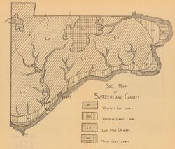
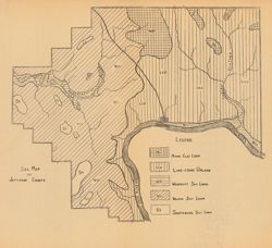
- Subject:
- Topical Subject: Loam soils, Geographic Subject: Switzerland County (Ind.), and Topical Subject: IGS Annual Reports
- Creator:
- Ward, L. C. (Louis Clinton), 1878-1931
- Publisher:
- Indiana. Department of Geology and Natural Resources
- Date Created:
- 1908
- Identifier:
- VAC3073-M-00370
- Genre:
- Thematic maps
- Geographic Location:
- Coordinates: W0851212 W0844704 N0385545 N0384115
- Related URL:
- Catalog URL: https://iucat.iu.edu/catalog/18349086
- Abstract:
- Detached from: A soil survey of Decatur, Jennings, Jefferson, Ripley, Dearborn, Ohio, and Switzerland counties, Indiana / L.C. Ward. In Indiana Dept. of Geol...
- Call Number:
- G4093.S9J3 1907 .S6
- Caption:
- Imprint: [Indianapolis] : [Indiana Department of Geology and Natural Resources], [1908]
- Physical Description:
- Scale: Scale not given. and Dimensions: on sheet 21 x 24 cm
- Alternate Identifier:
- Title Control Number: a18349086 and Alternate ID: 390726IP
- Persistent URL:
- https://purl.dlib.indiana.edu/iudl/images/VAC3073/VAC3073-M-00370
- Provenance:
- 32nd Annual Report (1907) / Indiana. Department of Geology and Natural Resources.
-
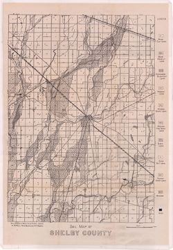
- Subject:
- Topical Subject: Geology, Topical Subject: Soils, Topical Subject: Mines and mineral resources, and Geographic Subject: Shelby County (Ind.)
- Creator:
- Hole, Allen David, 1866-1940
- Publisher:
- Indiana. Department of Geology and Natural Resources
- Date Created:
- 1912
- Identifier:
- VAC3073-M-01072
- Genre:
- Thematic maps
- Geographic Location:
- Coordinates: W0855711 W0853744 N0394156 N0392050
- Related URL:
- Catalog URL: https://iucat.iu.edu/catalog/16124745
- Abstract:
- Soils surveyed in 1911 by Allen D. Hole, assisted by B.W. Kelly, Mark Baldwin, and W.A. Roberts. Detached from: Soil survey of Hancock, Shelby, and Johnso...
- Call Number:
- G4093.S4.J3 1911 .H6
- Caption:
- Imprint: [Indianapolis] : [Department of Geology and Natural Resources, Indiana], [1912] and Imprint: [Indianapolis] : [Wm. B. Burford], [1912]
- Physical Description:
- Scale: Approximately 1:86,000 and Dimensions: 46 x 32 cm
- Alternate Identifier:
- Alternate ID: 390726IP and Title Control Number: a16124745
- Persistent URL:
- https://purl.dlib.indiana.edu/iudl/images/VAC3073/VAC3073-M-01072
- Provenance:
- 36th Annual Report (1911) / Indiana. Department of Geology and Natural Resources.
-
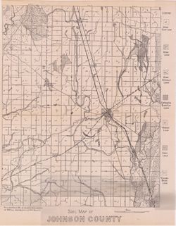
- Subject:
- Geographic Subject: Johnson County (Ind.) and Topical Subject: Soils
- Creator:
- Hole, Allen David, 1866-1940
- Publisher:
- Indiana. Department of Geology and Natural Resources
- Date Created:
- 1912
- Identifier:
- VAC3073-M-01071
- Genre:
- Thematic maps
- Geographic Location:
- Coordinates: W0861506 W0855702 N0393818 N0392030
- Related URL:
- Catalog URL: https://iucat.iu.edu/catalog/16124859
- Abstract:
- Detached from: Soil survey of Hancock, Shelby, and Johnson counties / Allen David Hole. In Thirty-sixth annual report of Department of Geology and Natural Re...
- Call Number:
- G4093.J7J3 1911 .H6
- Caption:
- Imprint: [Indianapolis] : [Department of Geology and Natural Resources, Indiana], [1912] and Imprint: [Indianapolis] : [Wm. B. Burford], [1912]
- Physical Description:
- Scale: Approximately 1:86,000 and Dimensions: 38 x 30 cm
- Alternate Identifier:
- Alternate ID: 390726IP and Title Control Number: a16124859
- Persistent URL:
- https://purl.dlib.indiana.edu/iudl/images/VAC3073/VAC3073-M-01071
- Provenance:
- 36th Annual Report (1911) / Indiana. Department of Geology and Natural Resources.
-
- Subject:
- Topical Subject: Loam soils, Geographic Subject: Jefferson County (Ind.), and Topical Subject: IGS Annual Reports
- Creator:
- Ward, L. C. (Louis Clinton), 1878-1931
- Publisher:
- Indiana. Department of Geology and Natural Resources
- Date Created:
- 1908
- Identifier:
- VAC3073-M-00101
- Genre:
- Geological maps
- Geographic Location:
- Coordinates: W0854104 W0851205 N0385500 N0383510
- Related URL:
- Catalog URL: https://iucat.iu.edu/catalog/18349087
- Abstract:
- Detached from: A soil survey of Decatur, Jennings, Jefferson, Ripley, Dearborn, Ohio, and Switzerland counties, Indiana / L.C. Ward. In Indiana Dept. of Geol...
- Call Number:
- G4093.J5J3 1908 .S6
- Caption:
- Imprint: [Indianapolis] : [Indiana Department of Geology and Natural Resources], [1908]
- Physical Description:
- Dimensions: on sheet 23 x 25 cm and Scale: Scale not given.
- Alternate Identifier:
- Alternate ID: 390726IP and Title Control Number: a18349087
- Persistent URL:
- https://purl.dlib.indiana.edu/iudl/images/VAC3073/VAC3073-M-00101
- Provenance:
- 32nd Annual Report (1907) / Indiana. Department of Geology and Natural Resources.
-
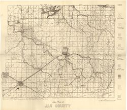
- Subject:
- Topical Subject: Soils and Geographic Subject: Jay County (Ind.)
- Creator:
- Hole, Allen David, 1866-1940
- Publisher:
- Indiana. Department of Geology and Natural Resources
- Date Created:
- 1915
- Identifier:
- VAC3073-M-01184
- Genre:
- Thematic maps
- Geographic Location:
- Coordinates: W0851312 W0844808 N0403419 N0401824
- Related URL:
- Catalog URL: https://iucat.iu.edu/catalog/16152007
- Abstract:
- Detached from: Soil survey of Jay County / Allen David Hole. In 39th Annual report of Department of Geology and Natural Resources, Indiana. From page 54 o...
- Call Number:
- G4093.J4J3 1914 .H6
- Caption:
- Imprint: [Indianapolis] : [Department of Geology and Natural Resources, Indiana], [1915]
- Physical Description:
- Dimensions: 35 x 42 cm and Scale: 1:84,000
- Persistent URL:
- https://purl.dlib.indiana.edu/iudl/images/VAC3073/VAC3073-M-01184
- Provenance:
- 39th Annual Report (1914) / Indiana. Department of Geology and Natural Resources.
-
- Subject:
- Geographic Subject: Hendricks County (Ind.), Topical Subject: IGS Annual Reports, Topical Subject: Mines and mineral resources, and Topical Subject: Geology
- Publisher:
- Indiana. Department of Geology and Natural Resources
- Date Created:
- 1914
- Identifier:
- VAC3073-M-01481
- Genre:
- Thematic maps
- Related URL:
- Catalog URL: new.iucat.iu.edu/catalog/4022273
- Abstract:
- From page 149 of the 38th Annual Report.
- Call Number:
- QE109 .A2 1913 map p149 Hendricks County
- Caption:
- Imprint: Indianapolis : 1914
- Persistent URL:
- https://purl.dlib.indiana.edu/iudl/images/VAC3073/VAC3073-M-01481
- Provenance:
- 38th Annual Report (1913) / Indiana. Department of Geology and Natural Resources.
-
- Subject:
- Topical Subject: Geology, Topical Subject: IGS Annual Reports, Topical Subject: Mines and mineral resources, and Geographic Subject: Benton County (Ind.)
- Creator:
- Jones, Grove B., 1877- and Brill, J. Bayard
- Publisher:
- Indiana. Department of Geology and Natural Resources
- Date Created:
- 1917
- Identifier:
- VAC3073-M-01478
- Genre:
- Thematic maps
- Related URL:
- Catalog URL: https://iucat.iu.edu/catalog/4022271
- Abstract:
- From page 29 of the 41st Annual Report.
- Call Number:
- QE109 .A2 1916
- Caption:
- Imprint: Indianapolis : 1917.
- Persistent URL:
- https://purl.dlib.indiana.edu/iudl/images/VAC3073/VAC3073-M-01478
- Provenance:
- 41st Annual Report (1916) / Indiana. Department of Geology and Natural Resources.
-
- Subject:
- Geographic Subject: Hancock County (Ind.) and Topical Subject: Soils
- Creator:
- Hole, Allen David, 1866-1940
- Publisher:
- Indiana. Department of Geology and Natural Resources
- Date Created:
- 1912
- Identifier:
- VAC3073-M-01073
- Genre:
- Thematic maps
- Geographic Location:
- Coordinates: W0855714 W0853434 N0395645 N0394149
- Related URL:
- Catalog URL: https://iucat.iu.edu/catalog/16124751
- Abstract:
- Soils surveyed in 1911 by Allen D. Hole, assisted by B.W. Kelly, Mark Baldwin, and W.A. Roberts. Detached from: Soil survey of Hancock, Shelby, and Johnso...
- Call Number:
- G4093.H3J3 1911 .H6
- Caption:
- Imprint: [Indianapolis] : [Wm. B. Burford], [1912] and Imprint: [Indianapolis] : [Department of Geology and Natural Resources, Indiana], [1912]
- Physical Description:
- Scale: Approximately 1:86,000 and Dimensions: 36 x 42 cm
- Alternate Identifier:
- Title Control Number: a16124751 and Alternate ID: 390726IP
- Persistent URL:
- https://purl.dlib.indiana.edu/iudl/images/VAC3073/VAC3073-M-01073
- Provenance:
- 36th Annual Report (1911) / Indiana. Department of Geology and Natural Resources.
-
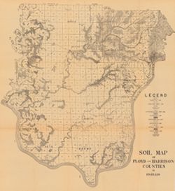
- Subject:
- Geographic Subject: Floyd County (Ind.), Geographic Subject: Harrison County (Ind.), and Topical Subject: Soils
- Creator:
- Ellis, R. W. (Robert W.)
- Publisher:
- Indiana. Department of Geology and Natural Resources
- Date Created:
- 1908
- Identifier:
- VAC3073-M-00741
- Genre:
- Thematic maps
- Geographic Location:
- Coordinates: W0861947 W0854538 N0382521 N0375728
- Related URL:
- Catalog URL: https://iucat.iu.edu/catalog/16096031
- Abstract:
- Detached from: A soil survey of Clark, Floyd, and Harrison counties / Robert W. Ellis. In Indiana Department of Geology and Natural Resources thirty-second a...
- Call Number:
- G4093.F5J3 1907 .E4
- Caption:
- Imprint: [Indianapolis] : [Indiana Department of Geology and Natural Resources], 1908
- Physical Description:
- Scale: Approximately 1:95,000 and Dimensions: 64 x 59 cm
- Alternate Identifier:
- Title Control Number: a16096031 and Alternate ID: 390726IP
- Persistent URL:
- https://purl.dlib.indiana.edu/iudl/images/VAC3073/VAC3073-M-00741
- Provenance:
- 32nd Annual Report (1907) / Indiana. Department of Geology and Natural Resources.
-
- Subject:
- Topical Subject: IGS Annual Reports, Geographic Subject: Decatur County (Ind.), and Topical Subject: Loam soils
- Publisher:
- Indiana. Department of Geology and Natural Resources
- Date Created:
- 1908
- Identifier:
- VAC3073-M-00136
- Genre:
- Geological maps
- Geographic Location:
- Coordinates: W0854116 W0851747 N0392712 N0390750
- Related URL:
- Catalog URL: https://iucat.iu.edu/catalog/18307561
- Abstract:
- Detached from: A soil survey of Decatur, Jennings, Jefferson, Ripley, Dearborn, Ohio, and Switzerland counties, Indiana / L.C. Ward. In Indiana Dept. of Geol...
- Call Number:
- G4093.D4J3 1907 .S6
- Caption:
- Imprint: [Indianapolis] : [Indiana Department of Geology and Natural Resources], [1908]
- Physical Description:
- Dimensions: on sheet 23 x 26 cm and Scale: Scale not given.
- Alternate Identifier:
- Title Control Number: a18307561 and Alternate ID: 390726IP
- Persistent URL:
- https://purl.dlib.indiana.edu/iudl/images/VAC3073/VAC3073-M-00136
- Provenance:
- 32nd Annual Report (1907) / Indiana. Department of Geology and Natural Resources.
-
- Subject:
- Topical Subject: Soils, Geographic Subject: Clark County (Ind.), and Geographic Subject: Floyd County (Ind.)
- Creator:
- Ellis, R. W. (Robert W.)
- Publisher:
- Indiana. Department of Geology and Natural Resources
- Date Created:
- 1908
- Identifier:
- VAC3073-M-00249
- Genre:
- Thematic maps
- Geographic Location:
- Coordinates: W0855940 W0852455 N0383624 N0381601
- Related URL:
- Catalog URL: https://iucat.iu.edu/catalog/16152110
- Abstract:
- Detached from: A soil survey of Clark, Floyd, and Harrison counties / Robert W. Ellis. In Indiana Department of Geology and Natural Resources thirty-second a...
- Call Number:
- G4093.C4J3 1907 .E4
- Caption:
- Imprint: [Indianapolis] : [Indiana Department of Geology and Natural Resources], [1908]
- Physical Description:
- Dimensions: 49 x 64 cm and Scale: Approximately 1:90,000
- Alternate Identifier:
- Title Control Number: a16152110 and Alternate ID: 390726IP
- Persistent URL:
- https://purl.dlib.indiana.edu/iudl/images/VAC3073/VAC3073-M-00249
- Provenance:
- 32nd Annual Report (1907) / Indiana. Department of Geology and Natural Resources.
-
- Subject:
- Topical Subject: Soils and Geographic Subject: Carroll County (Ind.)
- Creator:
- Erni, C. P. (Chester Prall), 1896- and Beals, C. C.
- Publisher:
- Indiana. Department of Geology and Natural Resources
- Date Created:
- 1917
- Identifier:
- VAC3073-M-01476
- Genre:
- Thematic maps
- Geographic Location:
- Coordinates: W0864600 W0862200 N0404400 N0402600
- Related URL:
- Catalog URL: https://iucat.iu.edu/catalog/15734020
- Abstract:
- Detached from: Carroll County / C.P. Erni and C.C. Beals. In Forty-first annual report of Dept. of Geology and Natural Resources, Indiana, 1916. Fort Wayne, ...
- Call Number:
- G4093.C2J3 1916 .E7
- Caption:
- Imprint: [Indianapolis] : Ind. Dept. of Geology, [1917]
- Physical Description:
- Scale: Approximately 1:63,630. 1 in. = 1 mile and Dimensions: 57 x 57 cm
- Alternate Identifier:
- Title Control Number: a15734020
- Persistent URL:
- https://purl.dlib.indiana.edu/iudl/images/VAC3073/VAC3073-M-01476
- Provenance:
- 41st Annual Report (1916) / Indiana. Department of Geology and Natural Resources.
-
- Subject:
- Topical Subject: Geology, Geographic Subject: Blackford County (Ind.), Topical Subject: IGS Annual Reports, and Topical Subject: Mines and mineral resources
- Creator:
- Quinn, E. J. (Edward J.) and Peacock, R. H.
- Publisher:
- Indiana. Department of Geology and Natural Resources
- Date Created:
- 1914
- Identifier:
- VAC3073-M-01482
- Genre:
- Thematic maps
- Related URL:
- Catalog URL: https://iucat.iu.edu/catalog/4022271
- Call Number:
- QE109 .A2 1913
- Caption:
- Imprint: Indianapolis : 1914
- Persistent URL:
- https://purl.dlib.indiana.edu/iudl/images/VAC3073/VAC3073-M-01482
- Provenance:
- 38th Annual Report (1913) / Indiana. Department of Geology and Natural Resources.
-
- Subject:
- Topical Subject: Soils and Geographic Subject: Vermillion County (Ind.)
- Creator:
- Coryell, Horace Noble, 1888-1965
- Publisher:
- Indiana. Department of Geology and Natural Resources
- Date Created:
- 1914
- Identifier:
- VAC3073-M-01157
- Genre:
- Thematic maps
- Geographic Location:
- Coordinates: W0873159 W0872113 N0400854 N0393626
- Related URL:
- Catalog URL: https://iucat.iu.edu/catalog/16151794
- Abstract:
- Detached from: Soil survey and Vermillion County / H.N. Coryell. In Indiana Department of Geology and Natural Resources thirty-eighth annual report ... 1913....
- Call Number:
- G4093.V4J3 1913 .C6
- Caption:
- Imprint: [Indianapolis] : State of Indiana, Department of Geology, [1914] [Indianapolis] : [Wm. B. Burford], [1914]
- Physical Description:
- Scale: Approximately 1:84,480 and Dimensions: 73 x 21 cm
- Alternate Identifier:
- Title Control Number: a16151794 and Alternate ID: 390726IP
- Persistent URL:
- https://purl.dlib.indiana.edu/iudl/images/VAC3073/VAC3073-M-01157
- Provenance:
- 38th Annual Report (1913) / Indiana. Department of Geology and Natural Resources.
-
- Subject:
- Topical Subject: Mines and mineral resources, Geographic Subject: Delaware County (Ind.), Topical Subject: IGS Annual Reports, and Topical Subject: Geology
- Publisher:
- Indiana. Department of Geology and Natural Resources
- Date Created:
- 1914
- Identifier:
- VAC3073-M-01484
- Genre:
- Thematic maps
- Related URL:
- Catalog URL: new.iucat.iu.edu/catalog/4022273
- Call Number:
- QE109 .A2 1913 Map p190 Delaware County
- Caption:
- Imprint: Indianapolis : 1914
- Persistent URL:
- https://purl.dlib.indiana.edu/iudl/images/VAC3073/VAC3073-M-01484
- Provenance:
- 38th Annual Report (1913) / Indiana. Department of Geology and Natural Resources.
-
- Subject:
- Topical Subject: IGS Annual Reports, Topical Subject: Mines and mineral resources, Topical Subject: Geology, and Geographic Subject: Howard County (Ind.)
- Creator:
- Rose, C. M. (Soil surveyor) and Coryell, Horace Noble, 1888-1965
- Publisher:
- Indiana. Department of Geology and Natural Resources
- Date Created:
- 1915
- Identifier:
- VAC3073-M-01479
- Genre:
- Thematic maps
- Related URL:
- Catalog URL: https://iucat.iu.edu/catalog/4022271
- Abstract:
- From page 21 of the 39th Annual Report.
- Call Number:
- QE109 .A2 1914
- Caption:
- Imprint: Indianapolis : 1915
- Persistent URL:
- https://purl.dlib.indiana.edu/iudl/images/VAC3073/VAC3073-M-01479
- Provenance:
- 39th Annual Report (1914) / Indiana. Department of Geology and Natural Resources.
-
- Subject:
- Geographic Subject: Elkhart County (Ind.), Topical Subject: Mines and mineral resources, Topical Subject: Geology, and Topical Subject: IGS Annual Reports
- Creator:
- Jones, Grove B., 1877- and Hesler, R. S.
- Publisher:
- Indiana. Department of Geology and Natural Resources
- Date Created:
- 1915
- Identifier:
- VAC3073-M-01474
- Genre:
- Thematic maps
- Related URL:
- Catalog URL: https://iucat.iu.edu/catalog/4022271
- Call Number:
- QE109 .A2 1914
- Caption:
- Imprint: Indianapolis : 1915
- Persistent URL:
- https://purl.dlib.indiana.edu/iudl/images/VAC3073/VAC3073-M-01474
- Provenance:
- 39th Annual Report (1914) / Indiana. Department of Geology and Natural Resources.
-
- Subject:
- Topical Subject: IGS Annual Reports, Geographic Subject: Clinton County (Ind.), Topical Subject: Mines and mineral resources, and Topical Subject: Geology
- Creator:
- Peacock, R. H., Rose, C. M. (Soil surveyor), and Tharp, W. E. (William Edgar)
- Publisher:
- Indiana. Department of Geology and Natural Resources
- Date Created:
- 1915
- Identifier:
- VAC3073-M-01480
- Genre:
- Thematic maps
- Related URL:
- Catalog URL: https://iucat.iu.edu/catalog/4022271
- Abstract:
- From page 89 of the 39th Annual Report.
- Call Number:
- QE109 .A2 1914
- Caption:
- Imprint: Indianapolis : 1915
- Persistent URL:
- https://purl.dlib.indiana.edu/iudl/images/VAC3073/VAC3073-M-01480
- Provenance:
- 39th Annual Report (1914) / Indiana. Department of Geology and Natural Resources.
-
- Subject:
- Topical Subject: Quarries and quarrying, Topical Subject: IGS Annual Reports, Geographic Subject: Indiana, Topical Subject: Sandstone, and Topical Subject: M...
- Creator:
- Hopkins, Thomas Cramer, 1861-1935 and Kindle, E. M. (Edward Martin), 1869-1940
- Publisher:
- Indiana. Department of Geology and Natural Resources
- Date Created:
- 1896
- Identifier:
- VAC3073-M-01179
- Genre:
- Index maps and Thematic maps
- Geographic Location:
- Coordinates: W0880500 W0844700 N0414500 N0374600
- Related URL:
- Catalog URL: https://iucat.iu.edu/catalog/18416374
- Abstract:
- Shows Mansfield sandstone areas and quarries. Plate VIII. Detached from: Area of Mansfield sandstone / mapped by T.C. Hopkins [and] E.M. Kindle. In Indian...
- Call Number:
- G4091.H5 1895 .H6
- Caption:
- Imprint: [Indianapolis] : [Indiana Department of Geology and Natural Resources], [1896] and Imprint: Indianapolis : Wm. B. Burford, [1896]
- Physical Description:
- Scale: Approximately 1:1,788,600 and Dimensions: 30 x 23 cm
- Alternate Identifier:
- Alternate ID: 390726IP and Title Control Number: a18416374
- Persistent URL:
- https://purl.dlib.indiana.edu/iudl/images/VAC3073/VAC3073-M-01179
- Provenance:
- 20th Annual Report (1895) / Indiana. Department of Geology and Natural Resources.
-
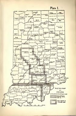
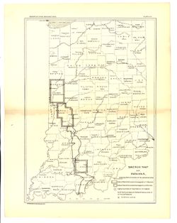
- Subject:
- Geographic Subject: Indiana and Topical Subject: IGS Annual Reports
- Publisher:
- Indiana. Department of Geology and Natural Resources
- Date Created:
- 1902
- Identifier:
- VAC3073-M-01575
- Genre:
- Index maps
- Geographic Location:
- Coordinates: W0880500 W0844700 N0414500 N0374600
- Related URL:
- Catalog URL: https://iucat.iu.edu/catalog/18418335
- Abstract:
- Index map showing locations covered by topographic maps represented on plates II-IV of the article. Shading indicates area covered by Topographic Section (Pl...
- Call Number:
- G4090 1901 .S5
- Caption:
- Imprint: [Indianapolis] : [Indiana Department of Geology and Natural Resources], [1902] and Imprint: [Indianapolis] : [Wm. B. Burford], [1902]
- Physical Description:
- Scale: Approximately 1:2,299,000 and Dimensions: on sheet 22 x 15 cm
- Alternate Identifier:
- Title Control Number: a18418335 and Alternate ID: 390726IP
- Persistent URL:
- https://purl.dlib.indiana.edu/iudl/images/VAC3073/VAC3073-M-01575
- Provenance:
- 26th Annual Report (1901) / Indiana. Department of Geology and Natural Resources.

- « Previous
- Next »
- 1
- 2
- 3
- 4