
Search Constraints
You searched for:
Publisher
Indiana. Department of Geology and Natural Resources
Remove constraint Publisher: Indiana. Department of Geology and Natural Resources
Subject
Topical Subject: Geology
Remove constraint Subject: Topical Subject: Geology
« Previous |
1 - 50 of 53
|
Next »
Search Results
-
- Subject:
- Topical Subject: Geology, Geographic Subject: Indiana, Topical Subject: IGS Annual Reports, Topical Subject: Minerals, and Topical Subject: Trenton Limestone
- Creator:
- Cubberley, Ellwood P., 1868-1941
- Publisher:
- Indiana. Department of Geology and Natural Resources
- Date Created:
- 1894
- Identifier:
- VAC3073-M-01555
- Genre:
- Geological maps and Index maps
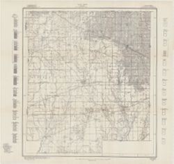
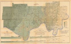
- Geographic Location:
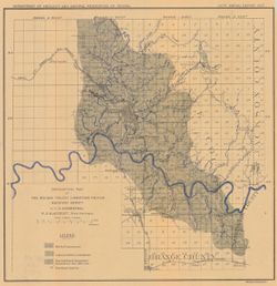
- Coordinates: W0880500 W0844700 N0414500 N0374600
- Related URL:
- Catalog URL: https://iucat.iu.edu/catalog/18224941
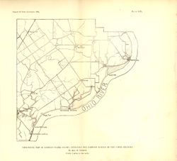
- Abstract:
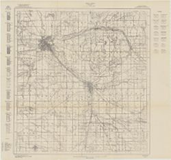
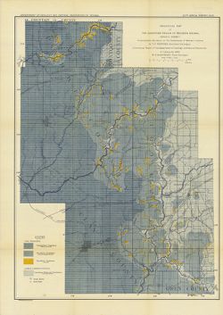
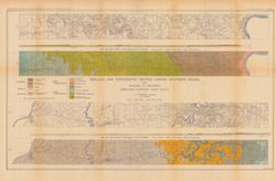
- Relation of Trenton rock to sea level shown with shading and contour lines. Map showing paths of the geological cross sections depicted in the illustrations ...
- Call Number:
- G4091.C57 1893 .C83
- Caption:
- Imprint: Indpls : lithographed by William B. Burford, [1894] and Imprint: [Indianapolis] : [Indiana, Dept. of Geology and Natural Resources], [1894]
- Physical Description:
- Scale: Scale not given. and Dimensions: 15 x 23 cm
- Alternate Identifier:
- Title Control Number: a18224941 and Alternate ID: 390726IP
- Persistent URL:
- https://purl.dlib.indiana.edu/iudl/images/VAC3073/VAC3073-M-01555
- Provenance:
- 18th Annual Report (1893) / Indiana. Department of Geology and Natural Resources.
-
- Subject:
- Geographic Subject: Monroe County (Ind.), Topical Subject: IGS Annual Reports, Topical Subject: Mines and mineral resources, and Topical Subject: Geology
- Creator:
- Shannon, C. W. (Charles William), 1879-1934
- Publisher:
- Indiana. Department of Geology and Natural Resources
- Date Created:
- 1908
- Identifier:
- VAC3073-M-01532
- Genre:
- Thematic maps
- Related URL:
- Catalog URL: https://iucat.iu.edu/catalog/11914890
- Abstract:
- Shows roads, earth and improved, railroads, school houses, and churches. Detached from: Soil survey of Monroe, Brown, Lawrence, Martin, Orange, Washington, ...
- Call Number:
- QE109 .A2 1907 Map p.123 Monroe County
- Caption:
- Imprint: [Indianapolis : 1908].
- Physical Description:
- Dimensions: on sheet 66 x 52 cm and Scale: Approximately 1:63,360
- Persistent URL:
- https://purl.dlib.indiana.edu/iudl/images/VAC3073/VAC3073-M-01532
-
- Subject:
- Topical Subject: Mines and mineral resources, Geographic Subject: Delaware County (Ind.), Topical Subject: IGS Annual Reports, and Topical Subject: Geology
- Publisher:
- Indiana. Department of Geology and Natural Resources
- Date Created:
- 1914
- Identifier:
- VAC3073-M-01484
- Genre:
- Thematic maps
- Related URL:
- Catalog URL: new.iucat.iu.edu/catalog/4022273
- Call Number:
- QE109 .A2 1913 Map p190 Delaware County
- Caption:
- Imprint: Indianapolis : 1914
- Persistent URL:
- https://purl.dlib.indiana.edu/iudl/images/VAC3073/VAC3073-M-01484
- Provenance:
- 38th Annual Report (1913) / Indiana. Department of Geology and Natural Resources.
-
- Subject:
- Topical Subject: Geology, Geographic Subject: Blackford County (Ind.), Topical Subject: IGS Annual Reports, and Topical Subject: Mines and mineral resources
- Creator:
- Quinn, E. J. (Edward J.) and Peacock, R. H.
- Publisher:
- Indiana. Department of Geology and Natural Resources
- Date Created:
- 1914
- Identifier:
- VAC3073-M-01482
- Genre:
- Thematic maps
- Related URL:
- Catalog URL: https://iucat.iu.edu/catalog/4022271
- Call Number:
- QE109 .A2 1913
- Caption:
- Imprint: Indianapolis : 1914
- Persistent URL:
- https://purl.dlib.indiana.edu/iudl/images/VAC3073/VAC3073-M-01482
- Provenance:
- 38th Annual Report (1913) / Indiana. Department of Geology and Natural Resources.
-
- Subject:
- Geographic Subject: Hendricks County (Ind.), Topical Subject: IGS Annual Reports, Topical Subject: Mines and mineral resources, and Topical Subject: Geology
- Publisher:
- Indiana. Department of Geology and Natural Resources
- Date Created:
- 1914
- Identifier:
- VAC3073-M-01481
- Genre:
- Thematic maps
- Related URL:
- Catalog URL: new.iucat.iu.edu/catalog/4022273
- Abstract:
- From page 149 of the 38th Annual Report.
- Call Number:
- QE109 .A2 1913 map p149 Hendricks County
- Caption:
- Imprint: Indianapolis : 1914
- Persistent URL:
- https://purl.dlib.indiana.edu/iudl/images/VAC3073/VAC3073-M-01481
- Provenance:
- 38th Annual Report (1913) / Indiana. Department of Geology and Natural Resources.
-
- Subject:
- Topical Subject: IGS Annual Reports, Geographic Subject: Clinton County (Ind.), Topical Subject: Mines and mineral resources, and Topical Subject: Geology
- Creator:
- Peacock, R. H., Rose, C. M. (Soil surveyor), and Tharp, W. E. (William Edgar)
- Publisher:
- Indiana. Department of Geology and Natural Resources
- Date Created:
- 1915
- Identifier:
- VAC3073-M-01480
- Genre:
- Thematic maps
- Related URL:
- Catalog URL: https://iucat.iu.edu/catalog/4022271
- Abstract:
- From page 89 of the 39th Annual Report.
- Call Number:
- QE109 .A2 1914
- Caption:
- Imprint: Indianapolis : 1915
- Persistent URL:
- https://purl.dlib.indiana.edu/iudl/images/VAC3073/VAC3073-M-01480
- Provenance:
- 39th Annual Report (1914) / Indiana. Department of Geology and Natural Resources.
-
- Subject:
- Topical Subject: IGS Annual Reports, Topical Subject: Mines and mineral resources, Topical Subject: Geology, and Geographic Subject: Howard County (Ind.)
- Creator:
- Rose, C. M. (Soil surveyor) and Coryell, Horace Noble, 1888-1965
- Publisher:
- Indiana. Department of Geology and Natural Resources
- Date Created:
- 1915
- Identifier:
- VAC3073-M-01479
- Genre:
- Thematic maps
- Related URL:
- Catalog URL: https://iucat.iu.edu/catalog/4022271
- Abstract:
- From page 21 of the 39th Annual Report.
- Call Number:
- QE109 .A2 1914
- Caption:
- Imprint: Indianapolis : 1915
- Persistent URL:
- https://purl.dlib.indiana.edu/iudl/images/VAC3073/VAC3073-M-01479
- Provenance:
- 39th Annual Report (1914) / Indiana. Department of Geology and Natural Resources.
-
- Subject:
- Topical Subject: Geology, Topical Subject: IGS Annual Reports, Topical Subject: Mines and mineral resources, and Geographic Subject: Benton County (Ind.)
- Creator:
- Jones, Grove B., 1877- and Brill, J. Bayard
- Publisher:
- Indiana. Department of Geology and Natural Resources
- Date Created:
- 1917
- Identifier:
- VAC3073-M-01478
- Genre:
- Thematic maps
- Related URL:
- Catalog URL: https://iucat.iu.edu/catalog/4022271
- Abstract:
- From page 29 of the 41st Annual Report.
- Call Number:
- QE109 .A2 1916
- Caption:
- Imprint: Indianapolis : 1917.
- Persistent URL:
- https://purl.dlib.indiana.edu/iudl/images/VAC3073/VAC3073-M-01478
- Provenance:
- 41st Annual Report (1916) / Indiana. Department of Geology and Natural Resources.
-
- Subject:
- Geographic Subject: Elkhart County (Ind.), Topical Subject: Mines and mineral resources, Topical Subject: Geology, and Topical Subject: IGS Annual Reports
- Creator:
- Jones, Grove B., 1877- and Hesler, R. S.
- Publisher:
- Indiana. Department of Geology and Natural Resources
- Date Created:
- 1915
- Identifier:
- VAC3073-M-01474
- Genre:
- Thematic maps
- Related URL:
- Catalog URL: https://iucat.iu.edu/catalog/4022271
- Call Number:
- QE109 .A2 1914
- Caption:
- Imprint: Indianapolis : 1915
- Persistent URL:
- https://purl.dlib.indiana.edu/iudl/images/VAC3073/VAC3073-M-01474
- Provenance:
- 39th Annual Report (1914) / Indiana. Department of Geology and Natural Resources.
-
- Subject:
- Topical Subject: IGS Annual Reports, Topical Subject: Geology, and Geographic Subject: Indiana
- Creator:
- Gorby, S. S. (Sylvester Scott)
- Publisher:
- Indiana. Department of Geology and Natural Resources
- Date Created:
- 1894
- Identifier:
- VAC3073-M-01252
- Genre:
- Geological maps
- Related URL:
- Catalog URL: https://iucat.iu.edu/catalog/4022270
- Call Number:
- QE109 .A2
- Caption:
- Imprint: Wm. B. Burford, Lith, Indianapolis
- Physical Description:
- Scale: Approximately 1:570,240. 9 miles to the inch
- Persistent URL:
- https://purl.dlib.indiana.edu/iudl/images/VAC3073/VAC3073-M-01252
- Provenance:
- 18th Annual Report (1893) / Indiana. Department of Geology and Natural Resources.
-
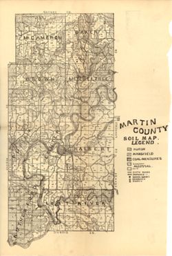
- Subject:
- Topical Subject: Mines and mineral resources, Topical Subject: Soils, Topical Subject: Geology, and Geographic Subject: Martin County (Ind.)
- Creator:
- Indiana. Department of Geology and Natural Resources
- Publisher:
- Indiana. Department of Geology and Natural Resources
- Date Created:
- 1908
- Identifier:
- VAC3073-M-01152
- Genre:
- Thematic maps
- Geographic Location:
- Coordinates: W0865527 W0864056 N0385416 N0382941
- Related URL:
- Catalog URL: https://iucat.iu.edu/catalog/16095827
- Abstract:
- Shows dirt roads and improved roads, school houses, churches, and stores. Detached from: Soil survey of Monroe, Brown, Lawrence, Martin, Orange, Washingto...
- Call Number:
- G4093.M5 J3 1907 .I53
- Caption:
- Imprint: [Indianapolis] : [Indiana Department of Geology and Natural Resources], [1908]
- Physical Description:
- Dimensions: 40 x 27 cm and Scale: Approximately 1:126,720
- Alternate Identifier:
- Alternate ID: 390726IP and Title Control Number: a16095827
- Persistent URL:
- https://purl.dlib.indiana.edu/iudl/images/VAC3073/VAC3073-M-01152
- Provenance:
- 32nd Annual Report (1907) / Indiana. Department of Geology and Natural Resources.
-
- Subject:
- Geographic Subject: Jefferson County (Ind.), Topical Subject: IGS Annual Reports, Topical Subject: Geology, Stratigraphic--Silurian, and Topical Subject: Geo...
- Creator:
- Foerste, Aug. F. (Aug. Frederic), 1862-1936
- Publisher:
- Indiana. Department of Geology and Natural Resources
- Date Created:
- 1897
- Identifier:
- VAC3073-M-01143
- Genre:
- Geological maps
- Geographic Location:
- Coordinates: W0853007 W0851205 N0385714 N0383358
- Related URL:
- Catalog URL: new.iucat.iu.edu/catalog/4022271
- Abstract:
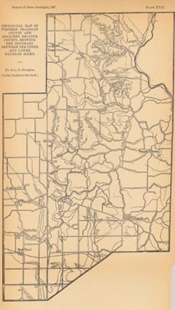
- "Plate XV." Detached from: A report on the geology of the middle and upper Silurian rocks of Clark, Jefferson, Ripley, Jennings and southern Decatu...
- Call Number:
- G4093.J5C57 1896 .F6
- Caption:
- Imprint: [Indianapolis] : [Indiana Dept. of Geology and Natural Resources], [1897]
- Physical Description:
- Dimensions: 36 x 25 cm and Scale: Approximately 1:126,720. 2 miles to the in.
- Alternate Identifier:
- Alternate ID: 390726IP
- Persistent URL:
- https://purl.dlib.indiana.edu/iudl/images/VAC3073/VAC3073-M-01143
- Provenance:
- 21st Annual Report (1896) / Indiana. Department of Geology and Natural Resources.
-
- Subject:
- Topical Subject: Geology, Stratigraphic--Silurian, Topical Subject: IGS Annual Reports, Geographic Subject: Clark County (Ind.), and Topical Subject: Geology
- Creator:
- Foerste, Aug. F. (Aug. Frederic), 1862-1936
- Publisher:
- Indiana. Department of Geology and Natural Resources
- Date Created:
- 1897
- Identifier:
- VAC3073-M-01142
- Genre:
- Geological maps
- Geographic Location:
- Coordinates: W0854136 W0852427 N0383546 N0382455
- Related URL:
- Catalog URL: https://iucat.iu.edu/catalog/17036420
- Abstract:
- "Plate XIV." Detached from: A report on the geology of the middle and upper Silurian rocks of Clark, Jefferson, Ripley, Jennings and southern Decat...
- Call Number:
- G4093.C4C57 1896 .F6
- Caption:
- Imprint: [Indianapolis] : [Indiana Dept. of Geology and Natural Resources], [1897]
- Physical Description:
- Dimensions: 23 x 24 cm and Scale: Approximately 1:126,720. 2 miles = 1 inch
- Alternate Identifier:
- Title Control Number: a17036420 and Alternate ID: 390726IP
- Persistent URL:
- https://purl.dlib.indiana.edu/iudl/images/VAC3073/VAC3073-M-01142
- Provenance:
- 21st Annual Report (1896) / Indiana. Department of Geology and Natural Resources.
-
- Subject:
- Geographic Subject: Ripley County (Ind.), Topical Subject: Geology, Topical Subject: IGS Annual Reports, Topical Subject: Geology, Stratigraphic--Silurian, a...
- Creator:
- Foerste, Aug. F. (Aug. Frederic), 1862-1936
- Publisher:
- Indiana. Department of Geology and Natural Resources
- Date Created:
- 1897
- Identifier:
- VAC3073-M-01141
- Genre:
- Geological maps
- Geographic Location:
- Coordinates: W0852641 W0850354 N0391837 N0385446
- Related URL:
- Catalog URL: https://iucat.iu.edu/catalog/17036513
- Abstract:
- "Plate XVI." Detached from: A report on the geology of the middle and upper Silurian rocks of Clark, Jefferson, Ripley, Jennings and southern Decat...
- Call Number:
- G4093.R5C57 1896 .F6
- Caption:
- Imprint: [Indianapolis] : [Indiana Dept. of Geology and Natural Resources], [1897]
- Physical Description:
- Scale: Approximately 1:126,720. 2 miles = 1 inch and Dimensions: 41 x 27 cm
- Alternate Identifier:
- Alternate ID: 390726IP and Title Control Number: a17036513
- Persistent URL:
- https://purl.dlib.indiana.edu/iudl/images/VAC3073/VAC3073-M-01141
- Provenance:
- 21st Annual Report (1896) / Indiana. Department of Geology and Natural Resources.
-
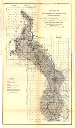
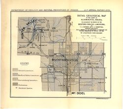
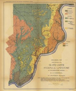
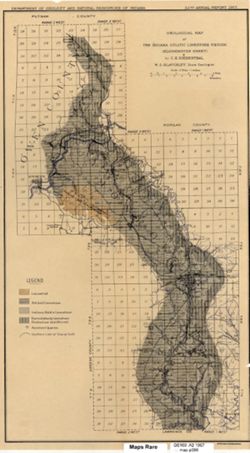
- Subject:
- Topical Subject: IGS Annual Reports, Geographic Subject: Bloomington (Ind.), Topical Subject: Limestone, Geographic Subject: Owen County (Ind.), Topical Subj...
- Publisher:
- Indiana. Department of Geology and Natural Resources
- Date Created:
- 1897
- Identifier:
- VAC3073-M-01139
- Genre:
- Geological maps
- Geographic Location:
- Coordinates: W0864646 W0862752 N0392732 N0385957
- Related URL:
- Catalog URL: https://iucat.iu.edu/catalog/18416402
- Abstract:
- To accompany the report on the Bedford Oolitic Limestone by T.C. Hopkins and C.E. Siebenthal. Shows abandoned quarries. Detached from: The Bedford oö...
- Call Number:
- G4094.B5C5 1896 .G4
- Caption:
- Imprint: [Indianapolis] : [Department of Geology and Natural Resources of Indiana], [1897] and Imprint: Indianapolis : Wm. Burford, [1897]
- Physical Description:
- Dimensions: 57 x 28 cm and Scale: Approximately 1:126,720. 2 miles = 1 inch
- Alternate Identifier:
- Alternate ID: 390726IP and Title Control Number: a18416402
- Persistent URL:
- https://purl.dlib.indiana.edu/iudl/images/VAC3073/VAC3073-M-01139
- Provenance:
- 21st Annual Report (1896) / Indiana. Department of Geology and Natural Resources.
-
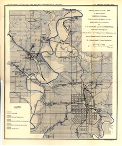
- Subject:
- Topical Subject: Geology, Topical Subject: IGS Annual Reports, Topical Subject: Limestone, Geographic Subject: Oolitic (Ind.), Geographic Subject: Lawrence C...
- Publisher:
- Indiana. Department of Geology and Natural Resources
- Date Created:
- 1897
- Identifier:
- VAC3073-M-01137
- Genre:
- Geological maps
- Geographic Location:
- Coordinates: W0863308 W0862727 N0385559 N0385035
- Related URL:
- Catalog URL: https://iucat.iu.edu/catalog/17036030
- Abstract:
- To accompany the report on the Bedford oölitic limestone, T.C. Hopkins and C.E. Siebenthal, assistant geologists : annual report of the Department of Ge...
- Call Number:
- G4094.B3C5 1896 .D4
- Caption:
- Imprint: [Indianapolis] : Dept. of Geology and Natural Resources of Indiana, [1897] and Imprint: Indianapolis, Ind. : Wm. B. Burford, Lith, [1897]
- Physical Description:
- Scale: Approximatley 1:31,680. 1 mile = 2 in. and Dimensions: 33 x 28 cm
- Alternate Identifier:
- Title Control Number: a17036030 and Alternate ID: 390726IP
- Persistent URL:
- https://purl.dlib.indiana.edu/iudl/images/VAC3073/VAC3073-M-01137
- Provenance:
- 21st Annual Report (1896) / Indiana. Department of Geology and Natural Resources.
-
- Subject:
- Topical Subject: Geology, Geographic Subject: Bloomington (Ind.), Topical Subject: Limestone, Geographic Subject: Monroe County (Ind.), and Topical Subject: ...
- Publisher:
- Indiana. Department of Geology and Natural Resources
- Date Created:
- 1897
- Identifier:
- VAC3073-M-01138
- Genre:
- Geological maps
- Geographic Location:
- Coordinates: W0863343 W0862934 N0391127 N0390900
- Related URL:
- Catalog URL: https://iucat.iu.edu/catalog/17035930
- Abstract:
- to accompany the report on the Bedford oölitic limestone, T.C. Hopkins and C.E. Siebenthal, assistant geologists : annual report of the Department of Ge...
- Call Number:
- G4094.B5C5 1896 .D4
- Caption:
- Imprint: Indianapolis, Ind. : Wm. B. Burford, Lith., [1897] and Imprint: [Indianapolis] : Dept. of Geology and Natural Resources of Indiana, [1897]
- Physical Description:
- Scale: Approximately 1:31,680. 1 mile = 2 in. and Dimensions: 17 x 20 cm
- Alternate Identifier:
- Alternate ID: 390726IP and Title Control Number: a17035930
- Persistent URL:
- https://purl.dlib.indiana.edu/iudl/images/VAC3073/VAC3073-M-01138
- Provenance:
- 21st Annual Report (1896) / Indiana. Department of Geology and Natural Resources.
-
- Subject:
- Geographic Subject: Lawrence County (Ind.), Geographic Subject: Bedford (Ind.), Topical Subject: IGS Annual Reports, Topical Subject: Limestone, and Topical ...
- Publisher:
- Indiana. Department of Geology and Natural Resources
- Date Created:
- 1897
- Identifier:
- VAC3073-M-01136
- Genre:
- Geological maps
- Geographic Location:
- Coordinates: W0864108 W0861527 N0385905 N0383934
- Related URL:
- Catalog URL: https://iucat.iu.edu/catalog/17036528
- Abstract:
- To accompany the report on the Bedford oölitic limestone, T.C. Hopkins and C.E. Siebenthal, assistant geologists : annual report of the Department of Ge...
- Call Number:
- G4094.B3C5 1896 .G4
- Caption:
- Imprint: [Indianapolis] : Dept. of Geology and Natural Resources of Indiana, [1897]
- Physical Description:
- Scale: Approximately 1:126,720. 2 miles = 1 inch and Dimensions: 35 x 35 cm
- Alternate Identifier:
- Alternate ID: 390726IP and Title Control Number: a17036528
- Persistent URL:
- https://purl.dlib.indiana.edu/iudl/images/VAC3073/VAC3073-M-01136
- Provenance:
- 21st Annual Report (1896) / Indiana. Department of Geology and Natural Resources.
-
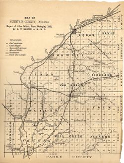
- Subject:
- Geographic Subject: Fountain County (Ind.), Topical Subject: Mines and mineral resources, Topical Subject: Geology, and Topical Subject: IGS Annual Reports
- Publisher:
- Indiana. Department of Geology and Natural Resources
- Date Created:
- 1882
- Identifier:
- VAC3073-M-01135
- Genre:
- Geological maps
- Related URL:
- Catalog URL: https://iucat.iu.edu/catalog/4022270
- Abstract:
- From page 88 of the 11th Annual Report.
- Call Number:
- QE109 .A2 1881 map p88
- Caption:
- Imprint: Indianapolis : 1882.
- Physical Description:
- Dimensions: 29 x 22 cm
- Alternate Identifier:
- Title Control Number: 390725IP
- Persistent URL:
- https://purl.dlib.indiana.edu/iudl/images/VAC3073/VAC3073-M-01135
- Provenance:
- 11th Annual Report (1881) / Indiana. Department of Geology and Natural History.
-
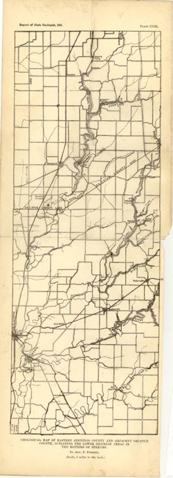
- Subject:
- Geographic Subject: Decatur County (Ind.), Topical Subject: IGS Annual Reports, Topical Subject: Geology, Geographic Subject: Jennings County (Ind.), and Top...
- Creator:
- Foerste, Aug. F. (Aug. Frederic), 1862-1936
- Publisher:
- Indiana. Department of Geology and Natural Resources
- Date Created:
- 1897
- Identifier:
- VAC3073-M-01134
- Genre:
- Geological maps
- Geographic Location:
- Coordinates: W0853927 W0852623 N0391045 N0384825
- Related URL:
- Catalog URL: https://iucat.iu.edu/catalog/18175777
- Abstract:
- "Plate XVII." Detached from: A report on the geology of the middle and upper Silurian rocks of Clark, Jefferson, Ripley, Jennings and southern Deca...
- Call Number:
- G4093.J6C57 1896 .F6
- Caption:
- Imprint: [Indianapolis] : [Indiana Dept. of Geology and Natural Resources], [1897]
- Physical Description:
- Scale: Approximately 1:126,720. 2 miles to the in. and Dimensions: 34 x 13 cm
- Alternate Identifier:
- Alternate ID: 390726IP and Title Control Number: a18175777
- Persistent URL:
- https://purl.dlib.indiana.edu/iudl/images/VAC3073/VAC3073-M-01134
- Provenance:
- 21st Annual Report (1896) / Indiana. Department of Geology and Natural Resources.
-
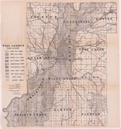
- Subject:
- Geographic Subject: Vigo County (Ind.), Topical Subject: Soils, Topical Subject: Geology, and Topical Subject: Mines and mineral resources
- Creator:
- Shannon, M. E., Shannon, C. W. (Charles William), 1879-1934, and United States. Bureau of Soils
- Publisher:
- Indiana. Department of Geology and Natural Resources
- Date Created:
- 1912
- Identifier:
- VAC3073-M-01092
- Genre:
- Thematic maps
- Geographic Location:
- Coordinates: W0873635 W0871156 N0393629 N0391532
- Related URL:
- Catalog URL: https://iucat.iu.edu/catalog/16131306
- Abstract:
- Shows dirt roads and improved public roads, railroads, school houses, cemeteries, and churches. Detached from: Soil survey of Clay, Knox, Sullivan, and Vi...
- Call Number:
- G4093.V5J3 1911 .S5
- Caption:
- Imprint: [Indianapolis] : [Department of Geology and Natural Resources, Indiana], [1912] [Indianapolis] : [Wm. B. Burford], [1912]
- Physical Description:
- Dimensions: 64 x 59 cm and Scale: Approximately 1:63,360
- Alternate Identifier:
- Title Control Number: a16131306 and Alternate ID: 390726IP
- Persistent URL:
- https://purl.dlib.indiana.edu/iudl/images/VAC3073/VAC3073-M-01092
- Provenance:
- 36th Annual Report (1911) / Indiana. Department of Geology and Natural Resources.
-
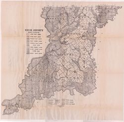
- Subject:
- Topical Subject: Mines and mineral resources, Topical Subject: Soils, Geographic Subject: Knox County (Ind.), and Topical Subject: Geology
- Creator:
- Shannon, M. E. and Shannon, C. W. (Charles William), 1879-1934
- Publisher:
- Indiana. Department of Geology and Natural Resources
- Date Created:
- 1912
- Identifier:
- VAC3073-M-01089
- Genre:
- Thematic maps
- Geographic Location:
- Coordinates: W0874524 W0870526 N0385428 N0382451
- Related URL:
- Catalog URL: https://iucat.iu.edu/catalog/16929613
- Abstract:
- Shows soil types, dirt roads, improved roads, railroads, schools, cemeteries, and churches. Detached from: Soil survey of Clay, Knox, Sullivan, and Vigo c...
- Call Number:
- G4093.K5J3 1911 .S5
- Caption:
- Imprint: [Indianapolis] : [Wm. B. Burford], [1912] and Imprint: [Indianapolis] : [Department of Geology and Natural Resources], [1912]
- Physical Description:
- Dimensions: 67 x 70 cm and Scale: Approximately 1:86,000
- Alternate Identifier:
- Title Control Number: a16929613 and Alternate ID: 390726IP
- Persistent URL:
- https://purl.dlib.indiana.edu/iudl/images/VAC3073/VAC3073-M-01089
- Provenance:
- 36th Annual Report (1911) / Indiana. Department of Geology and Natural Resources.
-
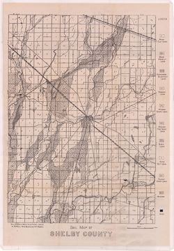
- Subject:
- Topical Subject: Geology, Topical Subject: Soils, Topical Subject: Mines and mineral resources, and Geographic Subject: Shelby County (Ind.)
- Creator:
- Hole, Allen David, 1866-1940
- Publisher:
- Indiana. Department of Geology and Natural Resources
- Date Created:
- 1912
- Identifier:
- VAC3073-M-01072
- Genre:
- Thematic maps
- Geographic Location:
- Coordinates: W0855711 W0853744 N0394156 N0392050
- Related URL:
- Catalog URL: https://iucat.iu.edu/catalog/16124745
- Abstract:
- Soils surveyed in 1911 by Allen D. Hole, assisted by B.W. Kelly, Mark Baldwin, and W.A. Roberts. Detached from: Soil survey of Hancock, Shelby, and Johnso...
- Call Number:
- G4093.S4.J3 1911 .H6
- Caption:
- Imprint: [Indianapolis] : [Department of Geology and Natural Resources, Indiana], [1912] and Imprint: [Indianapolis] : [Wm. B. Burford], [1912]
- Physical Description:
- Scale: Approximately 1:86,000 and Dimensions: 46 x 32 cm
- Alternate Identifier:
- Alternate ID: 390726IP and Title Control Number: a16124745
- Persistent URL:
- https://purl.dlib.indiana.edu/iudl/images/VAC3073/VAC3073-M-01072
- Provenance:
- 36th Annual Report (1911) / Indiana. Department of Geology and Natural Resources.
-
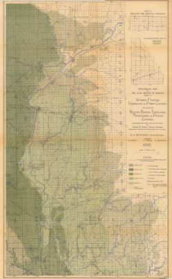
- Subject:
- Geographic Subject: Warren County (Ind.), Topical Subject: IGS Annual Reports, Geographic Subject: Vermillion County (Ind.), Geographic Subject: Attica (Ind....
- Creator:
- Hopkins, Thomas Cramer, 1861-1935
- Publisher:
- Indiana. Department of Geology and Natural Resources
- Date Created:
- 1896
- Identifier:
- VAC3073-M-01063
- Genre:
- Geological maps
- Geographic Location:
- Coordinates: W0872852 W0870229 N0402834 N0395753
- Related URL:
- Catalog URL: https://iucat.iu.edu/catalog/17228652
- Abstract:
- Detached from: The carboniferous sandstones of western Indiana / T.C. Hopkins. In Indiana Dept. of Geology and Natural Resources twentieth annual report. Ind...
- Call Number:
- G4094.A6C5 1895 .G4
- Caption:
- Imprint: Indianapolis : Wm. B. Burford, 1896.
- Physical Description:
- Scale: Approximately 1:126,720. 2 miles = 1 inch and Dimensions: 47 x 32 cm
- Alternate Identifier:
- Alternate ID: 390726IP and Title Control Number: a17228652
- Persistent URL:
- https://purl.dlib.indiana.edu/iudl/images/VAC3073/VAC3073-M-01063
- Provenance:
- 20th Annual Report (1895) / Indiana. Department of Geology and Natural Resources.
-
- Subject:
- Topical Subject: IGS Annual Reports, Topical Subject: Geology, Geographic Subject: Clay County (Ind.), Geographic Subject: Brazil (Ind.), Geographic Subject:...
- Creator:
- Hopkins, Thomas Cramer, 1861-1935
- Publisher:
- Indiana. Department of Geology and Natural Resources
- Date Created:
- 1896
- Identifier:
- VAC3073-M-01062
- Genre:
- Geological maps
- Geographic Location:
- Coordinates: W0871800 W0864800 N0395700 N0392500
- Related URL:
- Catalog URL: https://iucat.iu.edu/catalog/18175494
- Abstract:
- Detached from: The carboniferous sandstones of western Indiana / T.C. Hopkins. In Indiana Dept. of Geology and Natural Resources twentieth annual report. Ind...
- Call Number:
- G4094.B7C5 1895 .G4
- Caption:
- Imprint: Indianapolis : Wm. B. Burford, 1896.
- Physical Description:
- Dimensions: 53 x 38 cm and Scale: Approximately 1:126,720. 2 miles = 1 inch
- Alternate Identifier:
- Title Control Number: a18175494 and Alternate ID: 390726IP
- Persistent URL:
- https://purl.dlib.indiana.edu/iudl/images/VAC3073/VAC3073-M-01062
- Provenance:
- 20th Annual Report (1895) / Indiana. Department of Geology and Natural Resources.
-
- Subject:
- Topical Subject: IGS Annual Reports, Topical Subject: Mines and mineral resources, Topical Subject: Church buildings, Topical Subject: Geology, and Geographi...
- Creator:
- Kindle, E. M. (Edward Martin), 1869-1940
- Publisher:
- Indiana. Department of Geology and Natural Resources
- Date Created:
- 1896
- Identifier:
- VAC3073-M-01061
- Genre:
- Geological maps
- Geographic Location:
- Coordinates: W0864800 W0862700 N0384100 N0382400
- Related URL:
- Catalog URL: https://iucat.iu.edu/catalog/18175514
- Abstract:
- Shows the locations of coal, sandstone, and limestone areas as well as the locations of quarries, coal mines, and churches. Detached from: The carbonifero...
- Call Number:
- G4093.O6H1 1895 .K56
- Caption:
- Imprint: Indianapolis, Ind. : Wm. B. Burford, Lith., 1896
- Physical Description:
- Scale: Approximately 1:126,720. 2 miles = 1 inch and Dimensions: 33 x 27 cm
- Alternate Identifier:
- Title Control Number: a18175514 and Alternate ID: 390726IP
- Persistent URL:
- https://purl.dlib.indiana.edu/iudl/images/VAC3073/VAC3073-M-01061
- Provenance:
- 20th Annual Report (1895) / Indiana. Department of Geology and Natural Resources.
-

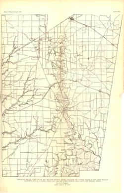
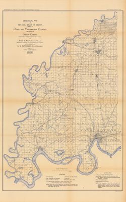
- Subject:
- Geographic Subject: Indiana, Geographic Subject: Ripley County (Ind.), Topical Subject: IGS Annual Reports, Geographic Subject: Jefferson County (Ind.), Topi...
- Creator:
- Cumings, E. R. (Edgar Roscoe), 1874-1967 and Foerste, Aug. F. (Aug. Frederic), 1862-1936
- Publisher:
- Indiana. Department of Geology and Natural Resources
- Date Created:
- 1908
- Identifier:
- VAC3073-M-01028
- Genre:
- Geological maps
- Geographic Location:
- Coordinates: W0854100 W0844600 N0391800 N0383300
- Related URL:
- Catalog URL: https://iucat.iu.edu/catalog/18307520
- Abstract:
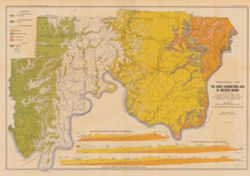
- "Boundary after Foerste." Detached from: The stratigraphy and paleontology of the Cincinnati series of Indiana / E.R. Cumings. In Indiana Dept. ...
- Call Number:
- G4091.C57 1908 .M3
- Caption:
- Imprint: [Indianapolis] : [Indiana Dept. of Geology and Natural Resources], [1908]
- Physical Description:
- Dimensions: on sheet 60 x 51 cm and Scale: Approximately 1:126,720. 2 miles to the 1 inch
- Alternate Identifier:
- Title Control Number: a18307520 and Alternate ID: 390726IP
- Persistent URL:
- https://purl.dlib.indiana.edu/iudl/images/VAC3073/VAC3073-M-01028
- Provenance:
- 32nd Annual Report (1907) / Indiana. Department of Geology and Natural Resources.
-
- Subject:
- Topical Subject: Mines and mineral resources, Topical Subject: Geology, Topical Subject: IGS Annual Reports, Geographic Subject: Perry County (Ind.), and Top...
- Publisher:
- Indiana. Department of Geology and Natural Resources
- Date Created:
- 1898
- Identifier:
- VAC3073-M-00991
- Genre:
- Geological maps and Geological cross-sections
- Geographic Location:
- Coordinates: W0864825 W0863629 N0380227 N0375602
- Related URL:
- Catalog URL: https://iucat.iu.edu/catalog/18349350
- Abstract:
- ncludes index map and 16 stratigraphic columns showing coal measurements. Plate LXVII. "Troy. Tell City." Detached from: Seventh annual report o...
- Call Number:
- G4093.P2H9 1876 .T69
- Caption:
- Imprint: [Indianapolis] : [Sentinel Company, printers], [1876] and Imprint: [Indianapolis] : [Geological Survey of Indiana], [1876]
- Physical Description:
- Scale: Approximately 1:63,360. Vertical scale indeterminable and Dimensions: on sheet 21 x 26 cm
- Alternate Identifier:
- Title Control Number: a18349350 and Alternate ID: 390726IP
- Persistent URL:
- https://purl.dlib.indiana.edu/iudl/images/VAC3073/VAC3073-M-00991
- Provenance:
- 7th Annual Report (1875) / Indiana. Geological Survey.
-
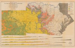
- Subject:
- Geographic Subject: Sullivan County (Ind.), Geographic Subject: Greene County (Ind.), Topical Subject: Geology, Topical Subject: Coal, and Topical Subject: I...
- Creator:
- Ashley, Geo. H. (George Hall), 1866-1951 and Siebenthal, C. E. (Claude Ellsworth), 1869-1930
- Publisher:
- Indiana. Department of Geology and Natural Resources
- Date Created:
- 1899
- Identifier:
- VAC3073-M-00945
- Genre:
- Geological cross-sections and Geological maps
- Geographic Location:
- Coordinates: W0873900 W0864200 N0391530 N0385400
- Related URL:
- Catalog URL: https://iucat.iu.edu/catalog/18265344
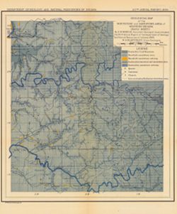
- Abstract:
- Relief shown by spot heights. Includes map showing the location of coal locations, coal features, and railroads, as well as geological cross sections for sev...
- Call Number:
- G4093.S8H9 1898 .A84
- Caption:
- Imprint: Indianapolis, Ind. : Wm. B. Burford, [1899]
- Physical Description:
- Scale: Approximately 1:126,720. 2 miles = 1 inch. Vertical scale approximately 1:4,800. 1 inch = 400 feet and Dimensions: 48 x 78 cm
- Alternate Identifier:
- Alternate ID: 390726IP and Title Control Number: a18265344
- Persistent URL:
- https://purl.dlib.indiana.edu/iudl/images/VAC3073/VAC3073-M-00945
- Provenance:
- 23rd Annual Report (1898) / Indiana. Department of Geology and Natural Resources.
-

- Subject:
- Geographic Subject: Crawford County (Ind.), Topical Subject: IGS Annual Reports, Geographic Subject: Dubois County (Ind.), Geographic Subject: Pike County (I...
- Creator:
- Kindle, E. M. (Edward Martin), 1869-1940, Price, J. A., and Ashley, Geo. H. (George Hall), 1866-1951
- Publisher:
- Indiana. Department of Geology and Natural Resources
- Date Created:
- 1899
- Identifier:
- VAC3073-M-00944
- Genre:
- Geological maps and Geological cross-sections
- Geographic Location:
- Coordinates: W0872700 W0862700 N0384200 N0381200
- Related URL:
- Catalog URL: https://iucat.iu.edu/catalog/18175917
- Abstract:
- Relief shown by spot heights. Includes map showing coal locations and features, and quarries as well as vertical cross-sections through center of Township 3 ...
- Call Number:
- G4093.P4H9 1898 .A84
- Caption:
- Imprint: Indianapolis : Burford, [1899]
- Physical Description:
- Dimensions: 48 x 78 cm and Scale: Approximately 1:126,720. 1 inch = 2 miles. Vertical scale approximately 1:4,800. 1 inch = 400 feet
- Alternate Identifier:
- Title Control Number: a18175917 and Alternate ID: 390726IP
- Persistent URL:
- https://purl.dlib.indiana.edu/iudl/images/VAC3073/VAC3073-M-00944
- Provenance:
- 23rd Annual Report (1898) / Indiana. Department of Geology and Natural Resources.
-
- Subject:
- Geographic Subject: Warrick County (Ind.), Geographic Subject: Spencer County (Ind.), Topical Subject: Geology, Topical Subject: IGS Annual Reports, Geograph...
- Creator:
- Ashley, Geo. H. (George Hall), 1866-1951, Price, J. A., and Kindle, E. M. (Edward Martin), 1869-1940
- Publisher:
- Indiana. Department of Geology and Natural Resources
- Date Created:
- 1899
- Identifier:
- VAC3073-M-00931
- Genre:
- Geological cross-sections and Geological maps
- Geographic Location:
- Coordinates: W0872823 W0862942 N0381446 N0374639
- Related URL:
- Catalog URL: https://iucat.iu.edu/catalog/16848969
- Abstract:
- Relief shown by profile. Shows two geological cross-sections. "Based upon Congressional land surveys, field work of Ind. Geol. Survey, county atlases.&q...
- Call Number:
- G4093.W4H9 1898 .A8x
- Caption:
- Imprint: Indianapolis : Burford, [1899] and Imprint: [Indianapolis, Ind.] : Dept. of Geology and Natural Resources of Indiana, [1899]
- Physical Description:
- Scale: Approximately 1:126,720. 2 miles = 1 inch. Vertical scale approximately 1:4,800. 400 feet = 1 inch and Dimensions: 49 x 77 cm
- Alternate Identifier:
- Alternate ID: 390726IP and Title Control Number: a16848969
- Persistent URL:
- https://purl.dlib.indiana.edu/iudl/images/VAC3073/VAC3073-M-00931
- Provenance:
- 23rd Annual Report (1898) / Indiana. Department of Geology and Natural Resources.
-
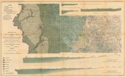
- Subject:
- Geographic Subject: Posey County (Ind.), Geographic Subject: Gibson County (Ind.), Geographic Subject: Indiana, Topical Subject: Coal, Topical Subject: Geolo...
- Creator:
- Ashley, Mary Martin and Ashley, Geo. H. (George Hall), 1866-1951
- Publisher:
- Indiana. Department of Geology and Natural Resources
- Date Created:
- 1899
- Identifier:
- VAC3073-M-00927
- Genre:
- Geological maps
- Geographic Location:
- Coordinates: W0880600 W0872700 N0383300 N0374500
- Related URL:
- Catalog URL: https://iucat.iu.edu/catalog/18188198
- Abstract:
- Relief shown by spot heights. "Based upon[:] B. F. & Co.'s Atlas of Indiana, 1876. Lake's Atlas of Gibson and Pike Counties, 1881. F. C. H. ...
- Call Number:
- QE109 .A2 1898 map p1408
- Caption:
- Imprint: Indianapolis, Ind. : Wm. B. Burford, [1899]
- Physical Description:
- Scale: Approximately 1:126,720. 2 miles = 1 inch and Dimensions: 78 x 48 cm
- Alternate Identifier:
- Title Control Number: a18188198 and Alternate ID: 390726IP
- Persistent URL:
- https://purl.dlib.indiana.edu/iudl/images/VAC3073/VAC3073-M-00927
- Provenance:
- 23rd Annual Report (1898) / Indiana. Department of Geology and Natural Resources.
-
- Subject:
- Topical Subject: Coal mines and mining, Geographic Subject: Indiana, Topical Subject: Geology, Topical Subject: Geology, Stratigraphic, and Topical Subject: ...
- Creator:
- Kindle, E. M. (Edward Martin), 1869-1940, Ashley, Geo. H. (George Hall), 1866-1951, and Blatchley, W. S. (Willis Stanley), 1859-1940
- Publisher:
- Indiana. Department of Geology and Natural Resources
- Date Created:
- 1903
- Identifier:
- VAC3073-M-00912
- Genre:
- Geological cross-sections and Geological maps
- Geographic Location:
- Coordinates: W0864100 W0853730 N0384700 N0382345
- Related URL:
- Catalog URL: https://iucat.iu.edu/catalog/16076838
- Abstract:
- Includes 4 East-West cross-sections through the center of townships 1, 2 and 3 North and 1 South. Vertical scale 1:9,600. Detached from: The geology of th...
- Call Number:
- G4091.C5 1902 .A82
- Caption:
- Imprint: [Indianapolis] : Department of Geology and Natural Resources of Indiana, [1903] and Imprint: Indianapolis, Ind. : Wm. B. Burford, [1903]
- Physical Description:
- Dimensions: 46 x 74 cm, on sheet 50 x 78 cm and Scale: Approximately 1:126,720. 2 miles = 1 in. Vertical scale approximately 1:9,600. 800 feet = 1 in.
- Alternate Identifier:
- Title Control Number: a16076838 and Alternate ID: 390726IP
- Persistent URL:
- https://purl.dlib.indiana.edu/iudl/images/VAC3073/VAC3073-M-00912
- Provenance:
- 27th Annual Report (1902) / Indiana. Department of Geology and Natural Resources.
-
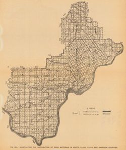
- Subject:
- Geographic Subject: Scott County (Ind.), Geographic Subject: Harrison County (Ind.), Topical Subject: Geology, Topical Subject: IGS Annual Reports, Geographi...
- Publisher:
- Indiana. Department of Geology and Natural Resources
- Date Created:
- 1906
- Identifier:
- VAC3073-M-00911
- Genre:
- Thematic maps
- Geographic Location:
- Coordinates: W0861948 W0852403 N0384955 N0375700
- Related URL:
- Catalog URL: https://iucat.iu.edu/catalog/18299034
- Abstract:
- Shows gravel locations. At head of title: Fig. 49A. Detached from: The roads and road materials of a portion of southwestern Indiana / A.E. Taylor. In Ind...
- Call Number:
- G4093.S3H5 1905 .I4
- Caption:
- Imprint: [Indianapolis] : [Indiana Dept. of Geology and Natural Resources], [1906]
- Physical Description:
- Scale: Approximately 1:371,000 and Dimensions: on sheet 27 x 23 cm
- Alternate Identifier:
- Alternate ID: 390726IP and Title Control Number: a18299034
- Persistent URL:
- https://purl.dlib.indiana.edu/iudl/images/VAC3073/VAC3073-M-00911
- Provenance:
- 30th Annual Report (1905) / Indiana. Department of Geology and Natural Resources.
-

- Subject:
- Geographic Subject: Clay County (Ind.), Topical Subject: Coal, Geographic Subject: Putnam County (Ind.), Topical Subject: IGS Annual Reports, Geographic Subj...
- Creator:
- Ashley, Geo. H. (George Hall), 1866-1951, Siebenthal, C. E. (Claude Ellsworth), 1869-1930, and Scovell, J. T. (Josiah Thomas), 1841-
- Publisher:
- Indiana. Department of Geology and Natural Resources
- Date Created:
- 1899
- Identifier:
- VAC3073-M-00899
- Genre:
- Geological maps and Geological cross-sections
- Geographic Location:
- Coordinates: W0873635 W0864028 N0393634 N0390856
- Related URL:
- Catalog URL: https://iucat.iu.edu/catalog/18259650
- Abstract:
- Relief shown by spot heights. Includes map showing coal locations and features, railroads, and quarries as well as vertical cross sections for Dana to Portla...
- Call Number:
- G4093.V5H9 1898 .A84
- Caption:
- Imprint: Indianapolis, Ind. : Wm. B. Burford, [1899]
- Physical Description:
- Scale: Approximately 1:126,720. 2 miles = 1 inch and Dimensions: 48 x 77 cm
- Alternate Identifier:
- Alternate ID: 390726IP and Title Control Number: a18259650
- Persistent URL:
- https://purl.dlib.indiana.edu/iudl/images/VAC3073/VAC3073-M-00899
- Provenance:
- 23rd Annual Report (1898) / Indiana. Department of Geology and Natural Resources.
-
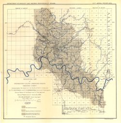
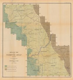
- Subject:
- Geographic Subject: Scott County (Ind.), Topical Subject: Limestone, Topical Subject: IGS Annual Reports, Topical Subject: Geology, Geographic Subject: Clark...
- Creator:
- Siebenthal, C. E. (Claude Ellsworth), 1869-1930
- Publisher:
- Indiana. Department of Geology and Natural Resources
- Date Created:
- 1901
- Identifier:
- VAC3073-M-00893
- Genre:
- Geological maps
- Geographic Location:
- Coordinates: W0855100 W0852100 N0384500 N0381530
- Related URL:
- Catalog URL: https://iucat.iu.edu/catalog/18188442
- Abstract:
- "NOTE - The eastern outcrop of the Knobstone is from map by Ind. Univ. Geol. Surv. Eastern outcrop of Devonian surveyed by J. A. Price. Eastern outcrop ...
- Call Number:
- G4091.H5 1900 .S54
- Caption:
- Imprint: Indianapolis, Ind. : Wm. B. Burford, Lith., [1901]
- Physical Description:
- Scale: Approximately 1:126,720. 2 miles = 1 inch and Dimensions: 47 x 38 cm
- Alternate Identifier:
- Title Control Number: a18188442 and Alternate ID: 390726IP
- Persistent URL:
- https://purl.dlib.indiana.edu/iudl/images/VAC3073/VAC3073-M-00893
- Provenance:
- 25th Annual Report (1900) / Indiana. Department of Geology and Natural Resources.
-
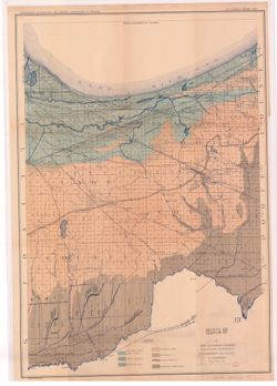
- Subject:
- Geographic Subject: Lake County (Ind.), Topical Subject: IGS Annual Reports, Geographic Subject: Porter County (Ind.), Topical Subject: Geology, and Topical ...
- Creator:
- Ashley, Geo. H. (George Hall), 1866-1951
- Publisher:
- Indiana. Department of Geology and Natural Resources
- Date Created:
- 1898
- Identifier:
- VAC3073-M-00806
- Genre:
- Geological maps
- Geographic Location:
- Coordinates: W0873136 W0865435 N0414259 N0410943
- Related URL:
- Catalog URL: https://iucat.iu.edu/catalog/17035654
- Abstract:
- Shows lakes, beaches, sand-dune area, morainic area, till plains, crest of moraine, and Kankakee Marsh area. Detached from: The geology of Lake and Porter...
- Call Number:
- G4093.L3C5 1897 .A8
- Caption:
- Imprint: [Indianapolis] : Department of Geology and Natural Resources of Indiana, [1898] and Imprint: Indianapolis, Ind. : Wm. B. Burford, lith., [1898]
- Physical Description:
- Dimensions: 55 x 42 cm and Scale: Approximately 1:126,720. 2 miles = 1 inch
- Alternate Identifier:
- Title Control Number: a17035654 and Alternate ID: 390726IP
- Persistent URL:
- https://purl.dlib.indiana.edu/iudl/images/VAC3073/VAC3073-M-00806
- Provenance:
- 22nd Annual Report (1897) / Indiana. Department of Geology and Natural Resources.
-
- Subject:
- Topical Subject: Mines and mineral resources, Topical Subject: Limestone, Topical Subject: Geology, Geographic Subject: Indiana, and Topical Subject: Geology...
- Creator:
- Newsom, John F. (John Flesher), 1869-1928
- Publisher:
- Indiana. Department of Geology and Natural Resources
- Date Created:
- 1902
- Identifier:
- VAC3073-M-00779
- Genre:
- Geological maps
- Geographic Location:
- Coordinates: W0863410 W0853500 N0390430 N0375720
- Related URL:
- Catalog URL: https://iucat.iu.edu/catalog/16077190
- Abstract:
- "Plate IV." Detached from: A geologic and topographic section across Southern Indiana / by J. F. Newsom. In Indiana Department of Geology and Na...
- Call Number:
- G4091.C5 1901 .N42
- Caption:
- Imprint: Indianapolis, Ind. : Wm. B. Burford, [1902] and Imprint: [Indianapolis] : Department of Geology and Natural Resources of Indiana, [1902]
- Physical Description:
- Scale: Scale approximately 1:190,080. 3 miles = 1 in. and Dimensions: 63 x 57 cm, on sheet 69 x 62 cm
- Alternate Identifier:
- Title Control Number: a16077190 and Alternate ID: 390726IP
- Persistent URL:
- https://purl.dlib.indiana.edu/iudl/images/VAC3073/VAC3073-M-00779
- Provenance:
- 26th Annual Report (1901) / Indiana. Department of Geology and Natural Resources.
-
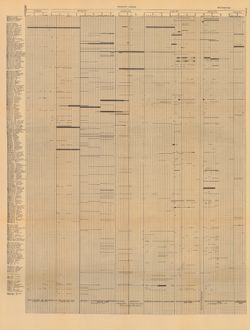
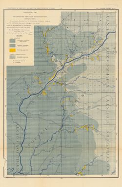
- Subject:
- Geographic Subject: Wayne County (Ind.), Topical Subject: Geology, Topical Subject: Paleontology, Geographic Subject: Tanners Creek (Ind. : Creek), Topical S...
- Creator:
- Cumings, E. R. (Edgar Roscoe), 1874-1967
- Publisher:
- Indiana. Department of Geology and Natural Resources
- Date Created:
- 1908
- Identifier:
- VAC3073-M-00692
- Genre:
- Graphs
- Geographic Location:
- Coordinates: W0845749 W0844849 N0395257 N0390333
- Related URL:
- Catalog URL: https://iucat.iu.edu/catalog/18298805
- Abstract:
- Title derived from captions. Chart showing stratigraphic measurements for paleontology samples collected around Tanner's Creek in Dearborn County and Ric...
- Call Number:
- G4091.C57 1908 .C86
- Caption:
- Imprint: [Indianapolis] : [Indiana Dept. of Geology and Natural Resources], [1908]
- Physical Description:
- Dimensions: 63 x 48 cm
- Alternate Identifier:
- Title Control Number: a18298805 and Alternate ID: 390726IP
- Persistent URL:
- https://purl.dlib.indiana.edu/iudl/images/VAC3073/VAC3073-M-00692
- Provenance:
- 32nd Annual Report (1907) / Indiana. Department of Geology and Natural Resources.
-
- Subject:
- Topical Subject: Geology, Geographic Subject: Indiana, and Topical Subject: Geology, Stratigraphic
- Creator:
- Newsom, John F. (John Flesher), 1869-1928
- Publisher:
- Indiana. Department of Geology and Natural Resources
- Date Created:
- 1902
- Identifier:
- VAC3073-M-00678
- Genre:
- Geological maps, Topographic maps, Strip maps, and Geological cross-sections
- Geographic Location:
- Coordinates: W0873650 W0852050 N0384430 N0383730
- Related URL:
- Catalog URL: https://iucat.iu.edu/catalog/16077374
- Abstract:
- Relief shown by contours. "Contour interval 40 feet." "Plate II." Detached from: A geologic and topographic section across Southern In...
- Call Number:
- G4091.C5 1901 .N41
- Caption:
- Imprint: Indianapolis, Ind. : Wm. B. Burford,[1902] and Imprint: [Indianapolis] : Department of Geology and Natural Resources of Indiana, [1902]
- Physical Description:
- Scale: Approximately 1:126,720. 2 miles = 1 in. Vertical scale approximately 1:24,000. 2,000 feet = 1 in. and Dimensions: 8 x 156 cm each, on sheet 56 x 84 cm
- Alternate Identifier:
- Title Control Number: a16077374 and Alternate ID: 390726IP
- Persistent URL:
- https://purl.dlib.indiana.edu/iudl/images/VAC3073/VAC3073-M-00678
- Provenance:
- 26th Annual Report (1901) / Indiana. Department of Geology and Natural Resources.
-
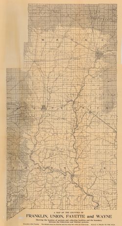
- Subject:
- Geographic Subject: Franklin County (Ind.), Topical Subject: Geology, Topical Subject: IGS Annual Reports, and Geographic Subject: Decatur County (Ind.)
- Creator:
- Foerste, Aug. F. (Aug. Frederic), 1862-1936
- Publisher:
- Indiana. Department of Geology and Natural Resources
- Date Created:
- 1898
- Identifier:
- VAC3073-M-00631
- Genre:
- Geological maps
- Geographic Location:
- Coordinates: W0852152 W0850747 N0393129 N0391606
- Related URL:
- Catalog URL: https://iucat.iu.edu/catalog/17227850
- Abstract:
- Plate XVII. "Report of State Geologist, 1897, plate xvii." Detached from: A report on the Niagara limestone quarries of Decatur, Franklin and...
- Call Number:
- G4093.F7C5 1897 .F64
- Caption:
- Imprint: [Indianapolis] : [Wm. B. Burford], [1898] and Imprint: [Indianapolis] : [Indiana Department of Geology and Natural Resources], [1898]
- Physical Description:
- Scale: Approximately 1:126,720. 2 miles = 1 inch and Dimensions: 25 x 15 cm
- Alternate Identifier:
- Title Control Number: a17227850 and Alternate ID: 390726IP
- Persistent URL:
- https://purl.dlib.indiana.edu/iudl/images/VAC3073/VAC3073-M-00631
- Provenance:
- 22nd Annual Report (1897) / Indiana. Department of Geology and Natural Resources.
-
- Subject:
- Topical Subject: Geology, Stratigraphic, Topical Subject: Geology, Geographic Subject: Indiana, Topical Subject: Mines and mineral resources, and Topical Sub...
- Creator:
- Ashley, Geo. H. (George Hall), 1866-1951, Blatchley, W. S. (Willis Stanley), 1859-1940, and Kindle, E. M. (Edward Martin), 1869-1940
- Publisher:
- Indiana. Department of Geology and Natural Resources
- Date Created:
- 1903
- Identifier:
- VAC3073-M-00394
- Genre:
- Geological cross-sections and Geological maps
- Geographic Location:
- Coordinates: W0864835 W0854540 N0382520 N0375015
- Related URL:
- Catalog URL: https://iucat.iu.edu/catalog/16076820
- Abstract:
- From the 27th Annual report of the Department of Geology and Natural Resources of Indiana, 1902. Includes three East-West cross-sections: through New Amsterd...
- Call Number:
- G4091.C5 1902 .A81
- Caption:
- Imprint: [Indianapolis] : [Wm. B. Burford], [1903] and Imprint: [Indianapolis] : [Indiana Department of Geology and Natural Resources], [1902]
- Physical Description:
- Scale: Approximately 1:126,720. 2 miles = 1 in. Vertical scale approximately 1:9,600. 800 feet = 1 in. and Dimensions: 51 x 76 cm, on sheet 56 x 80 cm
- Alternate Identifier:
- Title Control Number: a16076820 and Alternate ID: 390726IP
- Persistent URL:
- https://purl.dlib.indiana.edu/iudl/images/VAC3073/VAC3073-M-00394
- Provenance:
- 27th Annual Report (1902) / Indiana. Department of Geology and Natural Resources.
-
- Subject:
- Topical Subject: Mines and mineral resources, Topical Subject: Geology, Geographic Subject: Indiana, Topical Subject: Geology, Stratigraphic, and Topical Sub...
- Creator:
- Newsom, John F. (John Flesher), 1869-1928
- Publisher:
- Indiana. Department of Geology and Natural Resources
- Date Created:
- 1902
- Identifier:
- VAC3073-M-00381
- Genre:
- Geological maps
- Geographic Location:
- Coordinates: W0863410 W0853500 N0390430 N0375720
- Related URL:
- Catalog URL: https://iucat.iu.edu/catalog/16077083
- Abstract:
- Relief shown by contour lines. "Plate III." Detached from: A geologic and topographic section across Southern Indiana / by J. F. Newsom. In Indi...
- Call Number:
- G4091.C5 1901 .N43
- Caption:
- Imprint: [Indianapolis, Ind.] : [Indiana Department of Geology and Natural Resources], [1901] and Imprint: Indianapolis, Ind. : Wm. B. Burford, [1902]
- Physical Description:
- Scale: Scale approximately 1:190,080. 3 miles = 1 in. and Dimensions: 69 x 49 cm, on sheet 76 x 52 cm
- Alternate Identifier:
- Title Control Number: a16077083 and Alternate ID: 390726IP
- Persistent URL:
- https://purl.dlib.indiana.edu/iudl/images/VAC3073/VAC3073-M-00381
- Provenance:
- 26th Annual Report (1901) / Indiana. Department of Geology and Natural Resources.
-
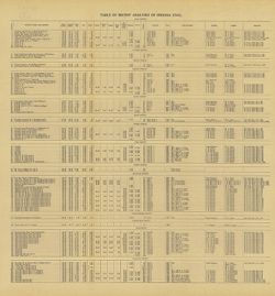
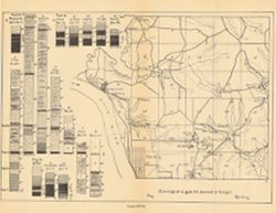
- Subject:
- Geographic Subject: Clay County (Ind.), Topical Subject: IGS Annual Reports, Topical Subject: Coal, Topical Subject: Mines and mineral resources, Geographic ...
- Creator:
- Ashley, Geo. H. (George Hall), 1866-1951
- Publisher:
- Indiana. Department of Geology and Natural Resources
- Date Created:
- 1909
- Identifier:
- VAC3073-M-00359
- Genre:
- Tables (Data) and Charts
- Related URL:
- Catalog URL: https://iucat.iu.edu/catalog/4022271
- Abstract:
- Detached from: The coal deposits of Indiana : a supplemental report to the one issued in 1898 / by Beorge H. Ashley. In Indiana Department of Geology and Nat...
- Call Number:
- QE109 .A2 1908 map p144
- Caption:
- Imprint: Indianapolis : 1909
- Physical Description:
- Dimensions: 40 x 38 cm
- Alternate Identifier:
- Title Control Number: 390726IP
- Persistent URL:
- https://purl.dlib.indiana.edu/iudl/images/VAC3073/VAC3073-M-00359
- Provenance:
- 33rd Annual Report (1908) / Indiana. Department of Geology and Natural Resources.
-
- Subject:
- Topical Subject: Limestone, Topical Subject: Geology, Geographic Subject: Owen County (Ind.), Geographic Subject: Monroe County (Ind.), and Topical Subject: ...
- Creator:
- Siebenthal, C. E. (Claude Ellsworth), 1869-1930
- Publisher:
- Indiana. Department of Geology and Natural Resources
- Date Created:
- 1908
- Identifier:
- VAC3073-M-00288
- Genre:
- Geological maps
- Geographic Location:
- Coordinates: W0864640 W0861903 N0392814 N0385936
- Related URL:
- Catalog URL: https://iucat.iu.edu/catalog/18307460
- Abstract:
- Also shows location of lacustral, Mitchell limestone, and Harrodsburg limestone as well as those of abandoned quarries and the southern limit of glacial drif...
- Call Number:
- G4093.M7H5 1907 .S5
- Caption:
- Imprint: [Indianapolis] : [Indiana Dept. of Geology and Natural Resources], [1908]
- Physical Description:
- Scale: Approximately 1:126,720. 2 miles = 1 inches and Dimensions: 44 x 25 cm
- Alternate Identifier:
- Alternate ID: 390726IP and Title Control Number: a18307460
- Persistent URL:
- https://purl.dlib.indiana.edu/iudl/images/VAC3073/VAC3073-M-00288
- Provenance:
- 32nd Annual Report (1907) / Indiana. Department of Geology and Natural Resources.
-
- Subject:
- Geographic Subject: Union County (Ind.), Geographic Subject: Franklin County (Ind.), Topical Subject: IGS Annual Reports, Geographic Subject: Indiana, Topica...
- Publisher:
- Indiana. Department of Geology and Natural Resources
- Date Created:
- 1908
- Identifier:
- VAC3073-M-00272
- Genre:
- Geological maps
- Related URL:
- Catalog URL: https://iucat.iu.edu/catalog/9676901
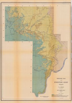
- Abstract:
- Showing the Location of sections and collecting localities and the boundary between the Ordovician and Silurian Systems. Detached from: The stratigraphy a...
- Call Number:
- QE109 .A2 1907 map p605
- Caption:
- Imprint: Indianapolis : 1908
- Physical Description:
- Dimensions: 67 x 37 cm and Scale: Approximately 1:126,720. 2 miles = 1 inch
- Alternate Identifier:
- Title Control Number: 390726IP
- Persistent URL:
- https://purl.dlib.indiana.edu/iudl/images/VAC3073/VAC3073-M-00272
- Provenance:
- 32nd Annual Report (1907) / Indiana. Department of Geology and Natural Resources.
-
- Subject:
- Geographic Subject: Putnam County (Ind.), Geographic Subject: Benton County (Ind.), Geographic Subject: Fountain County (Ind.), Geographic Subject: Newton Co...
- Creator:
- Ashley, Geo. H. (George Hall), 1866-1951, Siebenthal, C. E. (Claude Ellsworth), 1869-1930, and Kindle, E. M. (Edward Martin), 1869-1940
- Publisher:
- Indiana. Department of Geology and Natural Resources
- Date Created:
- 1899
- Identifier:
- VAC3073-M-00270
- Genre:
- Geological cross-sections and Geological maps
- Geographic Location:
- Coordinates: W0873200 W0865200 N0403000 N0393600
- Related URL:
- Catalog URL: https://iucat.iu.edu/catalog/18265361
- Abstract:
- Relief shown by spot heights. Includes map showing coal locations and features, railroads, and quarries as well as two inset maps for parts of Newton and Ben...
- Call Number:
- G4093.W3H9 1898 .A84
- Caption:
- Imprint: Indianapolis, Ind. : Wm. B. Burford, [1899]
- Physical Description:
- Dimensions: 79 x 48 cm and Scale: Approximately 1:126,720. 2 miles = 1 inch
- Alternate Identifier:
- Alternate ID: 390726IP and Title Control Number: a18265361
- Persistent URL:
- https://purl.dlib.indiana.edu/iudl/images/VAC3073/VAC3073-M-00270
- Provenance:
- 23rd Annual Report (1898) / Indiana. Department of Geology and Natural Resources.
-
- Subject:
- Topical Subject: Abandoned quarries, Geographic Subject: Lawrence County (Ind.), Topical Subject: Limestone, Topical Subject: Geology, and Topical Subject: I...
- Creator:
- Siebenthal, C. E. (Claude Ellsworth), 1869-1930
- Publisher:
- Indiana. Department of Geology and Natural Resources
- Date Created:
- 1908
- Identifier:
- VAC3073-M-00256
- Genre:
- Geological maps
- Geographic Location:
- Coordinates: W0864110 W0861629 N0385940 N0383929
- Related URL:
- Catalog URL: https://iucat.iu.edu/catalog/18307475
- Abstract:
- Also shows locations of Mitchell and Harrodsburg limestones as well as abandoned quarries in Lawrence County and small parts of Orange, Washington, and Jacks...
- Call Number:
- G4093.L5H5 1907 .S5
- Caption:
- Imprint: [Indianapolis] : [Indiana Dept. of Geology and Natural Resources], [1908]
- Physical Description:
- Dimensions: 32 x 31 cm and Scale: Approximately 1:126,720. 2 miles = 1 inches
- Alternate Identifier:
- Title Control Number: a18307475 and Alternate ID: 390726IP
- Persistent URL:
- https://purl.dlib.indiana.edu/iudl/images/VAC3073/VAC3073-M-00256
- Provenance:
- 32nd Annual Report (1907) / Indiana. Department of Geology and Natural Resources.
-
- Subject:
- Topical Subject: Mines and mineral resources, Topical Subject: Geology, Topical Subject: IGS Annual Reports, Topical Subject: Geology, Stratigraphic, Geograp...
- Publisher:
- Indiana. Department of Geology and Natural Resources
- Date Created:
- 1885
- Identifier:
- VAC3073-M-00075
- Genre:
- Geological cross-sections and Geological maps
- Geographic Location:
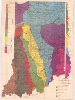
- Coordinates: W0880500 W0844700 N0414500 N0374600
- Related URL:
- Catalog URL: https://iucat.iu.edu/catalog/18437099
- Abstract:
- Variant title: Geological map of Indiana, revised and corrected. 1 map and 2 sections on 1 sheet. Shows county seats, townships, towns & post offices, ra...
- Call Number:
- QE109 .A2 1884
- Caption:
- Imprint: Indianapolis : [Indiana Department of Geology and Natural History], [1885] and Imprint: Indianapolis : Wm. B. Burford, [1885]
- Physical Description:
- Dimensions: 85 x 63 cm and Scale: Approximately 1:570,240. 9 miles to the inch
- Alternate Identifier:
- Alternate ID: 390725IP and Title Control Number: a18437099
- Persistent URL:
- https://purl.dlib.indiana.edu/iudl/images/VAC3073/VAC3073-M-00075
- Provenance:
- 14th Annual Report (1884) / Indiana. Department of Geology and Natural History.
-
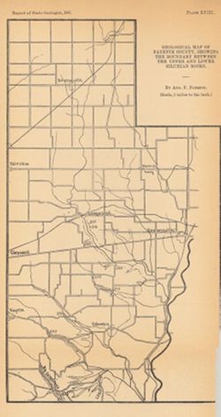
- Subject:
- Topical Subject: Mines and mineral resources, Topical Subject: Geology, Geographic Subject: Fayette County (Ind.), and Topical Subject: IGS Annual Reports
- Creator:
- Foerste, Aug. F. (Aug. Frederic), 1862-1936
- Publisher:
- Indiana. Department of Geology and Natural Resources
- Date Created:
- 1898
- Identifier:
- VAC3073-M-00063
- Genre:
- Geological maps
- Geographic Location:
- Coordinates: W0851831 W0850639 N0394639 N0393044
- Related URL:
- Catalog URL: https://iucat.iu.edu/catalog/17035593
- Abstract:
- Plate XVIII. Detached from: A report on the Niagara limestone quarries of Decatur, Franklin and Fayette Counties ... / August F. Foerste. In Indiana Departme...
- Call Number:
- G4093.F3C5 1898 .F64
- Caption:
- Imprint: [Indianapolis] : [Wm. B. Burford], [1898] and Imprint: [Indiana] : [Department of Geology and Natural Resources], [1898]
- Physical Description:
- Scale: Approximately 1:126,720 and Dimensions: 26 x 14 cm
- Alternate Identifier:
- Title Control Number: a17035593 and Alternate ID: 390726IP
- Persistent URL:
- https://purl.dlib.indiana.edu/iudl/images/VAC3073/VAC3073-M-00063
- Provenance:
- 22nd Annual Report (1897) / Indiana. Department of Geology and Natural Resources.
