
Search Constraints
You searched for:
Campus
IUB
Remove constraint Campus: IUB
Pages
0-99 pages
Remove constraint Pages: 0-99 pages
Publisher
[publisher not identified]
Remove constraint Publisher: [publisher not identified]
1 - 40 of 40
Search Results
-
- Subject:
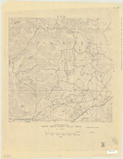
- Topical Subject: Karst, Topical Subject: Caves, and Geographic Subject: Van Buren (Monroe County, Ind. : Township)
- Creator:
- Powell, Richard L.
- Publisher:
- [publisher not identified]
- Date Created:
- 1968
- Identifier:
- VAC3073-M-00797
- Genre:
- Thematic maps
- Geographic Location:
- Coordinates: W0864058 W0863422 N0390956 N0390443
- Related URL:
- Catalog URL: https://iucat.iu.edu/catalog/5327209
- Abstract:
- Blue line print. _x000d_ "Base prepared from Bloomington, Clear Creek, Stanford and Whitehall topographic quadrangles, U.S.G.S, by the Indiana Geolog...
- Call Number:
- G4094.V28 C23 1968 .P69
- Caption:
- Imprint: [Place of publication not identified] : [publisher not identified], [1968?]
- Physical Description:
- Scale: 1:6,000 and Dimensions: 91 x 92 cm
- Alternate Identifier:
- Title Control Number: a5327209
- Persistent URL:
- https://purl.dlib.indiana.edu/iudl/images/VAC3073/VAC3073-M-00797
-
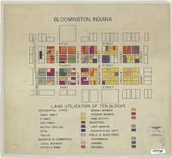
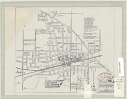
- Subject:
- Topical Subject: Land use and Geographic Subject: Bloomington (Ind.)
- Publisher:
- [publisher not identified]
- Date Created:
- 1950
- Identifier:
- VAC3073-M-00589
- Genre:
- Thematic maps
- Geographic Location:
- Coordinates: W0863206 W0863146 N0391000 N0390950
- Related URL:
- Catalog URL: https://iucat.iu.edu/catalog/5299843
- Abstract:
- Shows the area from the Monon Railroad on the west to Grant Street on the east, and from Fifth Street on the north to Third Street on the South. Pen-and-ink...
- Call Number:
- G4094.B5 G4 1950 .B5
- Caption:
- Imprint: [Place of publication not identified] : [publisher not identified], [195-?]
- Physical Description:
- Scale: Scale not given. and Dimensions: 47 x 52 cm
- Alternate Identifier:
- Title Control Number: a5299843
- Persistent URL:
- https://purl.dlib.indiana.edu/iudl/images/VAC3073/VAC3073-M-00589
-
- Subject:
- Geographic Subject: Lawrence County (Ind.), Geographic Subject: Lost River Watershed (Ind.), Topical Subject: Drainage, Geographic Subject: Lost River (Ind. ...
- Creator:
- Malott, Clyde A.
- Publisher:
- [publisher not identified]
- Date Created:
- 1927
- Identifier:
- VAC3073-M-01239
- Genre:
- Manuscript maps and Thematic maps
- Geographic Location:
- Coordinates: W0864059 W0861220 N0384445 N0383053
- Related URL:
- Catalog URL: https://iucat.iu.edu/catalog/7745828
- Abstract:
- Pen, colored ink and colored pencils on drafting cloth. Includes table of drainage areas.
- Call Number:
- G4092.L8C315 1927 .M35
- Caption:
- Imprint: [Place of publication not identified] : [publisher not identified], 1927.
- Physical Description:
- Scale: 1:31,680 and Dimensions: 93 x 111 cm
- Persistent URL:
- https://purl.dlib.indiana.edu/iudl/images/VAC3073/VAC3073-M-01239
-
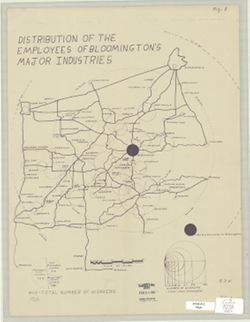
- Subject:
- Topical Subject: Labor supply, Geographic Subject: Bloomington Region (Ind.), and Geographic Subject: Indiana
- Publisher:
- [publisher not identified]
- Date Created:
- 1950
- Identifier:
- VAC3073-M-00273
- Genre:
- Thematic maps
- Geographic Location:
- Coordinates: W0873409 W0855213 N0394859 N0381725
- Related URL:
- Catalog URL: https://iucat.iu.edu/catalog/5296476
- Abstract:
- Blue line print. Shows numbers of employees of Bloomington's major industries by home cities and towns with graduated circles. Includes graphs.
- Call Number:
- G4094.B5G8 1950 .D57
- Caption:
- Imprint: [place of publication not identified : publisher not identified, between 1950 and 1969?]
- Physical Description:
- Dimensions: 48 x 36 cm and Scale: 1:500,000
- Alternate Identifier:
- Title Control Number: a5296476
- Persistent URL:
- https://purl.dlib.indiana.edu/iudl/images/VAC3073/VAC3073-M-00273
-
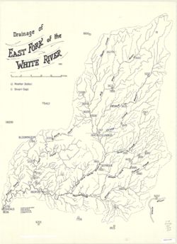
- Subject:
- Geographic Subject: White River (Ind. : River) and Topical Subject: Rivers
- Publisher:
- [publisher not identified]
- Date Created:
- 1959
- Identifier:
- VAC3073-M-00269
- Genre:
- Thematic maps
- Geographic Location:
- Coordinates: W0874400 W0850300 N0401200 N0382400
- Related URL:
- Catalog URL: https://iucat.iu.edu/catalog/4962801
- Abstract:
- Shows weather stations and stream gages.
- Call Number:
- G4092 .W5 1959 .D7
- Caption:
- Imprint: [place of publication not identified] : [publisher not identified], 1959.
- Physical Description:
- Scale: 1:250,000 and Dimensions: 77 x 56 cm
- Alternate Identifier:
- Title Control Number: a4962801
- Persistent URL:
- https://purl.dlib.indiana.edu/iudl/images/VAC3073/VAC3073-M-00269
-
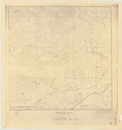
![Van Buren Township, [Monroe County, Indiana]](https://iiif.uits.iu.edu/iiif/2/t148gk22c%2Ffiles%2F0702bb5b-5263-4741-9365-b7eacb14395d/full/250,/0/default.jpg)
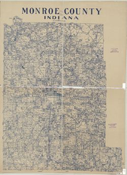
- Subject:
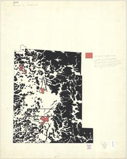
- Geographic Subject: Van Buren (Monroe County, Ind. : Township)
- Creator:
- Schwender, William A.
- Publisher:
- [publisher not identified]
- Date Created:
- 1960
- Identifier:
- VAC3073-M-00584
- Genre:
- Maps
- Geographic Location:
- Coordinates: W0864033 W0863411 N0390956 N0390443
- Related URL:
- Catalog URL: https://iucat.iu.edu/catalog/5327104
- Abstract:
- Pen and ink and black and colored pencil on tracing paper.
- Call Number:
- G4094.V28 1960 .S39
- Caption:
- Imprint: [place of publication not identified] : [publisher not identified], [196-?]
- Physical Description:
- Scale: 1:24,000 and Dimensions: 40 x 40 cm
- Alternate Identifier:
- Title Control Number: a5327104
- Persistent URL:
- https://purl.dlib.indiana.edu/iudl/images/VAC3073/VAC3073-M-00584
-
- Subject:
- Geographic Subject: Union City (Ind.) and Geographic Subject: Union City (Ohio)
- Creator:
- Bower, C. W.
- Publisher:
- [publisher not identified]
- Date Created:
- 1977
- Identifier:
- VAC3073-M-00726
- Genre:
- Maps
- Geographic Location:
- Coordinates: W0845017 W0844820 N0401256 N0401121
- Related URL:
- Catalog URL: https://iucat.iu.edu/catalog/4979453
- Abstract:
- "Date 2-10-66." Indexed for points of interest.
- Call Number:
- G4094 .U5 1977 .B6
- Caption:
- Imprint: [Indiana?] : [publisher not identified], [1977]
- Physical Description:
- Scale: Scale not given. and Dimensions: 21 x 24 cm
- Alternate Identifier:
- Title Control Number: a4979453
- Persistent URL:
- https://purl.dlib.indiana.edu/iudl/images/VAC3073/VAC3073-M-00726
-
- Subject:
- Topical Subject: Phytogeography, Geographic Subject: Indiana, and Geographic Subject: Monroe, Lake, Watershed (Ind.)
- Publisher:
- [publisher not identified]
- Date Created:
- 1975
- Identifier:
- VAC3073-M-00799
- Genre:
- Thematic maps
- Geographic Location:
- Coordinates: W0863138 W0861831 N0390711 N0385936
- Related URL:
- Catalog URL: https://iucat.iu.edu/catalog/5302581
- Abstract:
- Appears to be a reprint of a map from the 1975 Lake Monroe Land Suitability Study.
- Call Number:
- G4092.M6 D2 1975 .L3
- Caption:
- Imprint: [Place of publication not identified] : [publisher not identified], [197?]
- Physical Description:
- Scale: 1:24,000 and Dimensions: 67 x 94 cm
- Alternate Identifier:
- Title Control Number: a5302581
- Persistent URL:
- https://purl.dlib.indiana.edu/iudl/images/VAC3073/VAC3073-M-00799
-
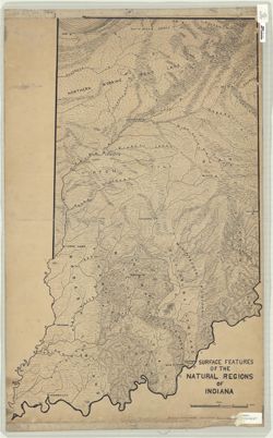
- Subject:
- Topical Subject: Landforms and Geographic Subject: Indiana
- Creator:
- Switzer, J. E. (Jesse Elmer)
- Publisher:
- [publisher not identified]
- Date Created:
- 1932
- Identifier:
- VAC3073-M-00387
- Genre:
- Thematic maps and Physical maps
- Geographic Location:
- Coordinates: W0880700 W0844500 N0414500 N0375200
- Related URL:
- Catalog URL: https://iucat.iu.edu/catalog/2797935
- Abstract:
- Relief shown by landform drawings. Pen-and-ink. Drawn at Indiana University. "Indiana Supplement." For date of drawing, see Kingsbury, Rob...
- Call Number:
- G4091 .C2 1932 .S9
- Caption:
- Imprint: [place of publication not identified] : [publisher not identified], [1932?]
- Physical Description:
- Dimensions: 90 x 57 cm and Scale: 1:500,000
- Alternate Identifier:
- Title Control Number: CAG8345BB
- Persistent URL:
- https://purl.dlib.indiana.edu/iudl/images/VAC3073/VAC3073-M-00387
-
- Subject:
- Geographic Subject: Van Buren (Monroe County, Ind. : Township), Topical Subject: Karst, and Topical Subject: Watersheds
- Creator:
- Powell, Richard L.
- Publisher:
- [publisher not identified]
- Date Created:
- 1970
- Identifier:
- VAC3073-M-00338
- Genre:
- Thematic maps
- Geographic Location:
- Coordinates: W0864023 W0863813 N0390944 N0390627
- Related URL:
- Catalog URL: https://iucat.iu.edu/catalog/5327168
- Abstract:
- Blue line print. "Rlp-1970."
- Call Number:
- G4094.V28 C315 1970 .P69
- Caption:
- Imprint: [place of publication not identified] : [publisher not identified], 1970?]
- Physical Description:
- Scale: 1:12,000 and Dimensions: 46 x 46 cm
- Alternate Identifier:
- Title Control Number: a5327168
- Persistent URL:
- https://purl.dlib.indiana.edu/iudl/images/VAC3073/VAC3073-M-00338
-
- Subject:
- Topical Subject: Forests and forestry and Geographic Subject: Monroe County (Ind.)
- Creator:
- Hart, John Fraser
- Publisher:
- [publisher not identified]
- Date Created:
- 1960
- Identifier:
- VAC3073-M-00714
- Genre:
- Thematic maps
- Geographic Location:
- Coordinates: W0864108 W0861902 N0392120 N0385926
- Related URL:
- Catalog URL: https://iucat.iu.edu/catalog/5303041
- Abstract:
- Also shows 3 areas of overgrown quarries.
- Call Number:
- G4093.M7K2 1960 .H37
- Caption:
- Imprint: [Place of publication not identified] : [publisher not identified], [196-?]
- Physical Description:
- Scale: Scale not given. and Dimensions: 46 x 38 cm, on sheet 74 x 59 cm
- Alternate Identifier:
- Title Control Number: a5303041
- Persistent URL:
- https://purl.dlib.indiana.edu/iudl/images/VAC3073/VAC3073-M-00714
-
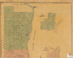
- Subject:
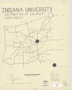
- Geographic Subject: Monroe County (Ind.), Geographic Subject: Bloomington Region (Ind.), Geographic Subject: Indiana University, Bloomington, Topical Subject...
- Publisher:
- [publisher not identified]
- Date Created:
- 1950
- Identifier:
- VAC3073-M-00954
- Genre:
- Thematic maps
- Geographic Location:
- Coordinates: W0873300 W0855300 N0394700 N0384000
- Related URL:
- Catalog URL: https://iucat.iu.edu/catalog/5298168
- Abstract:
- Blue line print. Shows numbers of Indiana University salaried employees by home cities and towns with graduated circles. Includes graphs.
- Call Number:
- G4094.B5 G8 1950 .I5
- Caption:
- Imprint: [Place of publication not identified] : [publisher not identified], [between 1950 and 1969?]
- Physical Description:
- Scale: 1:500,000 and Dimensions: 46 x 36 cm
- Alternate Identifier:
- Title Control Number: a5298168
- Persistent URL:
- https://purl.dlib.indiana.edu/iudl/images/VAC3073/VAC3073-M-00954
-
- Subject:
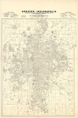
- Geographic Subject: Indianapolis Metropolitan Area (Ind.) and Geographic Subject: Indianapolis (Ind.)
- Creator:
- George F. Cram Company
- Publisher:
- [publisher not identified]
- Date Created:
- 1976
- Identifier:
- VAC3073-M-00127
- Genre:
- Maps
- Geographic Location:
- Coordinates: W0861941 W0855614 N0395538 N0393755
- Related URL:
- Catalog URL: https://iucat.iu.edu/catalog/4659169
- Abstract:
- Shows radial distances.
- Call Number:
- G4094.I4 1976 .C6
- Caption:
- Imprint: Indianapolis : [publisher not identified], [1976]
- Physical Description:
- Scale: 1:27,500 and Dimensions: 154 x 119 cm
- Alternate Identifier:
- Title Control Number: CAF3100BB
- Persistent URL:
- https://purl.dlib.indiana.edu/iudl/images/VAC3073/VAC3073-M-00127
-
- Subject:
- Topical Subject: Railroads and Geographic Subject: Indiana
- Creator:
- Indiana University. Center for Urban and Regional Analysis.
- Publisher:
- [publisher not identified]
- Date Created:
- 1976
- Identifier:
- VAC3073-M-00346
- Genre:
- Thematic maps
- Geographic Location:
- Coordinates: W0880500 W0844700 N0414500 N0374600
- Related URL:
- Catalog URL: https://iucat.iu.edu/catalog/4942831
- Call Number:
- G4091 .P3 1976 .I6
- Caption:
- Imprint: [Bloomington] : [publisher not identified], 1976.
- Physical Description:
- Dimensions: 127 x 97 cm and Scale: 1:375,000
- Alternate Identifier:
- Title Control Number: a4942831
- Persistent URL:
- https://purl.dlib.indiana.edu/iudl/images/VAC3073/VAC3073-M-00346
-
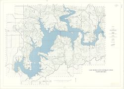
![Lake Monroe land suitability study [map] : topographic map.](https://iiif.uits.iu.edu/iiif/2/2z10xt29p%2Ffiles%2Feaa1f09e-b438-41d3-91c8-07be188b6db3/full/250,/0/default.jpg)
- Subject:
- Geographic Subject: Monroe, Lake, Watershed (Ind.)
- Publisher:
- [publisher not identified]
- Date Created:
- 1975
- Identifier:
- VAC3073-M-00188
- Genre:
- Topographic maps
- Geographic Location:
- Coordinates: W0863222 W0862507 N0390705 N0385918
- Related URL:
- Catalog URL: https://iucat.iu.edu/catalog/4942905
- Abstract:
- Appears to be a reprint of a map from the 1975 Lake Monroe Land Suitability Study.
- Call Number:
- G4092.M6 C2 1975 .L3
- Caption:
- Imprint: [place of publication not identified : publisher not identified, 197-?]
- Physical Description:
- Dimensions: 67 x 94 cm and Scale: 1:24,000
- Alternate Identifier:
- Title Control Number: a4942905
- Persistent URL:
- https://purl.dlib.indiana.edu/iudl/images/VAC3073/VAC3073-M-00188
-
- Subject:
- Topical Subject: Real property, Topical Subject: Landowners, Geographic Subject: Muncie (Ind.), and Topical Subject: Natural gas
- Creator:
- Hefel, Toney C.
- Publisher:
- [publisher not identified]
- Date Created:
- 1889
- Identifier:
- VAC3073-M-00839
- Genre:
- Cadastral maps
- Geographic Location:
- Coordinates: W0852716 W0851914 N0401426 N0400856
- Related URL:
- Catalog URL: https://iucat.iu.edu/catalog/7330426
- Abstract:
- Blueprint. Partial cadastral map showing landowners.
- Call Number:
- G4094.M9G46 1889 .H44
- Caption:
- Imprint: [Place of publication not identified] : [publisher not identified], [1889?]
- Physical Description:
- Dimensions: 61 x 85 cm and Scale: 1:10,500
- Alternate Identifier:
- Title Control Number: a7330426
- Persistent URL:
- https://purl.dlib.indiana.edu/iudl/images/VAC3073/VAC3073-M-00839
-
- Subject:
- Geographic Subject: Salt Creek (Monroe County, Ind. : Township) and Geographic Subject: Polk (Monroe County, Ind. : Township)
- Publisher:
- [publisher not identified]
- Date Created:
- 1968
- Identifier:
- VAC3073-M-00738
- Genre:
- Maps
- Geographic Location:
- Coordinates: W0862744 W0862208 N0390955 N0390436
- Related URL:
- Catalog URL: https://iucat.iu.edu/catalog/5283126
- Abstract:
- Black line print. Relief shown by contours and spot heights. Shows Overlook and Peninsula properties located just northeast of the Lake Monroe causeway, I...
- Call Number:
- G4094.S219 1968 .O94
- Caption:
- Imprint: [Place of publication not identified] : [publisher not identified], 1968.
- Physical Description:
- Dimensions: 53 x 130 cm and Scale: 1:2,400
- Alternate Identifier:
- Title Control Number: a5283126
- Persistent URL:
- https://purl.dlib.indiana.edu/iudl/images/VAC3073/VAC3073-M-00738
-
- Subject:
- Geographic Subject: Lake County (Ind.), Topical Subject: Land use, Geographic Subject: Gary (Ind.), and Geographic Subject: Gary Region (Ind.)
- Creator:
- Guiney, Donald
- Publisher:
- [publisher not identified]
- Date Created:
- 1950
- Identifier:
- VAC3073-M-00712
- Genre:
- Thematic maps
- Geographic Location:
- Coordinates: W0872601 W0871319 N0413919 N0413118
- Related URL:
- Catalog URL: https://iucat.iu.edu/catalog/7314939
- Abstract:
- Title supplied by cataloger. Produced as a class project in the Indiana University, Geography Department. Land use hand colored in colored pencil. Base map: ...
- Call Number:
- G4094.G2G4 1950 .G85
- Caption:
- Imprint: [Place of publication not identified]: [publisher not identified], [195-?]
- Physical Description:
- Dimensions: 53 x 70 cm and Scale: 1:29,000
- Persistent URL:
- https://purl.dlib.indiana.edu/iudl/images/VAC3073/VAC3073-M-00712
-
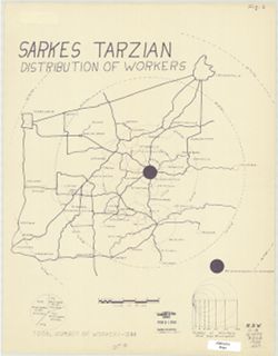
- Subject:
- Topical Subject: Labor supply, Geographic Subject: Bloomington Region (Ind.), and Geographic Subject: Indiana
- Publisher:
- [publisher not identified]
- Date Created:
- 1950
- Identifier:
- VAC3073-M-00710
- Genre:
- Thematic maps
- Geographic Location:
- Coordinates: W0864342 W0854642 N0395150 N0383133
- Related URL:
- Catalog URL: https://iucat.iu.edu/catalog/5296737
- Abstract:
- Blue line print. Shows numbers of Sarkes Tarzian employees by home cities and towns with graduated circles. Includes graphs.
- Call Number:
- G4094.B5 G8 1950 .S27
- Caption:
- Imprint: [Place of publication not identified] : [publisher not identified], [between 1950 and 1969?]
- Physical Description:
- Dimensions: 46 x 36 cm and Scale: 1:500,000
- Alternate Identifier:
- Title Control Number: a5296737
- Persistent URL:
- https://purl.dlib.indiana.edu/iudl/images/VAC3073/VAC3073-M-00710
-
![Area map [map] : Nashville and park entrance](https://iiif.uits.iu.edu/iiif/2/cf95kd75c%2Ffiles%2F50f0a63b-dc6d-4bda-a229-140148a2252e/full/250,/0/default.jpg)
- Subject:
- Geographic Subject: Brown County State Park (Ind.) and Geographic Subject: Nashville (Ind.)
- Publisher:
- [publisher not identified]
- Date Created:
- 1970
- Identifier:
- VAC3073-M-00225
- Genre:
- Maps
- Geographic Location:
- Coordinates: W0861450 W0861220 N0391229 N0391130
- Related URL:
- Catalog URL: https://iucat.iu.edu/catalog/4896982
- Abstract:
- Blue line print. Shows corporate limits of Nashville Indiana, roads, some buildings, Salt Creek, the north entrance to Brown County State Park and distances...
- Call Number:
- G4094 .N25 1970 .A74
- Caption:
- Imprint: [place of publication not identified] : [publisher not identified], [1970?]
- Physical Description:
- Dimensions: 42 x 66 cm and Scale: Scale not given.
- Alternate Identifier:
- Title Control Number: a4896982
- Persistent URL:
- https://purl.dlib.indiana.edu/iudl/images/VAC3073/VAC3073-M-00225
-
- Subject:
- Geographic Subject: Tipton (Ind.)
- Publisher:
- [publisher not identified]
- Date Created:
- 1945
- Identifier:
- VAC3073-M-00848
- Genre:
- Maps
- Geographic Location:
- Coordinates: W0860411 W0860109 N0401751 N0401602
- Related URL:
- Catalog URL: https://iucat.iu.edu/catalog/7032612
- Abstract:
- Blue line. "Dec. 15, 1945."
- Call Number:
- G4094.T6 1945 .C58
- Caption:
- Imprint: [Place of publication not identified] : [publisher not identified], [1945]
- Physical Description:
- Dimensions: 28 x 19 cm and Scale: 1:12,000
- Alternate Identifier:
- Title Control Number: a7032612
- Persistent URL:
- https://purl.dlib.indiana.edu/iudl/images/VAC3073/VAC3073-M-00848
-
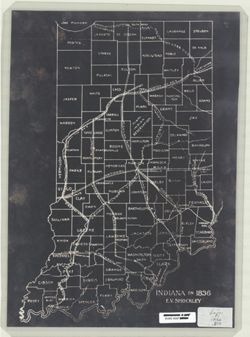
- Subject:
- Topical Subject: Transportation and Geographic Subject: Indiana
- Creator:
- Shockley, Ernest V.
- Publisher:
- [publisher not identified]
- Date Created:
- 1936
- Identifier:
- VAC3073-M-00791
- Genre:
- Thematic maps
- Geographic Location:
- Coordinates: W0880500 W0844700 N0414500 N0374600
- Related URL:
- Catalog URL: https://iucat.iu.edu/catalog/4662696
- Abstract:
- Negative photostat. Shows roads, railroads, canals, counties and cities.
- Call Number:
- G4091 .P1 1836 .S56
- Caption:
- Imprint: [Place of publication not identified] : [publisher not identified], 1836.
- Physical Description:
- Scale: Scale not given. and Dimensions: 37 x 25 cm
- Alternate Identifier:
- Title Control Number: CAH1804BB
- Persistent URL:
- https://purl.dlib.indiana.edu/iudl/images/VAC3073/VAC3073-M-00791
-
![Road map of Monroe County, Indiana [cartographic material] : adopted January 20, 1966](https://iiif.uits.iu.edu/iiif/2/cn69n8374%2Ffiles%2F6cca8b9b-6d94-4804-b65e-3ae6e2fa6cb3/full/250,/0/default.jpg)
- Subject:
- Topical Subject: Roads and Geographic Subject: Monroe County (Ind.)
- Creator:
- Klooz, C. J.
- Publisher:
- [publisher not identified]
- Date Created:
- 1966
- Identifier:
- VAC3073-M-00906
- Genre:
- Road maps
- Geographic Location:
- Coordinates: W0864108 W0861902 N0392120 N0385926
- Related URL:
- Catalog URL: https://iucat.iu.edu/catalog/5304275
- Abstract:
- Blue line print. Includes text and indexes.
- Call Number:
- G4093.M7P2 1966 .K66
- Caption:
- Imprint: [Place of publication not identified] : [publisher not identified], [1966]
- Physical Description:
- Dimensions: 123 x 100 cm and Scale: 1:34,000
- Alternate Identifier:
- Title Control Number: a5304275
- Persistent URL:
- https://purl.dlib.indiana.edu/iudl/images/VAC3073/VAC3073-M-00906
-
![Geology [Monroe County, Ind.]](https://iiif.uits.iu.edu/iiif/2/qv33t0191%2Ffiles%2F7a237c59-b869-4ad6-928c-c058aa8367af/full/250,/0/default.jpg)
- Subject:
- Topical Subject: Geology and Geographic Subject: Monroe County (Ind.)
- Publisher:
- [publisher not identified]
- Date Created:
- 1960
- Identifier:
- VAC3073-M-00396
- Genre:
- Thematic maps and Geological maps
- Geographic Location:
- Coordinates: W0864108 W0861902 N0392120 N0385926
- Related URL:
- Catalog URL: https://iucat.iu.edu/catalog/5302998
- Call Number:
- G4093.M7 C5 1960 .G46
- Caption:
- Imprint: [place of publication not identified] : [publisher not identified], [196-?]
- Physical Description:
- Scale: Scale not given. and Dimensions: 48 x 47 cm
- Alternate Identifier:
- Title Control Number: a5302998
- Persistent URL:
- https://purl.dlib.indiana.edu/iudl/images/VAC3073/VAC3073-M-00396
-
- Subject:
- Geographic Subject: Indianapolis (Ind.)
- Publisher:
- [publisher not identified]
- Date Created:
- 1990
- Identifier:
- VAC3073-M-00404
- Genre:
- Maps
- Geographic Location:
- Coordinates: W0862046 W0855642 N0395557 N0393918
- Related URL:
- Catalog URL: https://iucat.iu.edu/catalog/4686431
- Abstract:
- Blue line print. _x000d_ Shows major roads and highways. _x000d_ Annotated by stuck-on-lettering indicating recreational points of interest, such as pa...
- Call Number:
- G4094.I4 1990z .I4
- Caption:
- Imprint: [place of publication not identified] : [publisher not identified], [199-?]
- Physical Description:
- Scale: 1:58,000 and Dimensions: 65 x 67 cm
- Alternate Identifier:
- Title Control Number: CAW1968BB
- Persistent URL:
- https://purl.dlib.indiana.edu/iudl/images/VAC3073/VAC3073-M-00404
-
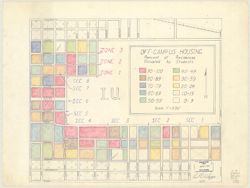
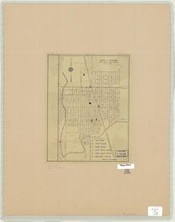
- Subject:
- Topical Subject: Indiana University, Bloomington, Geographic Subject: Indiana University, Bloomington, Geographic Subject: Bloomington (Ind.), and Topical Su...
- Creator:
- Whippo, Paul D.
- Publisher:
- [publisher not identified]
- Date Created:
- 1960
- Identifier:
- VAC3073-M-00048
- Genre:
- Thematic maps
- Geographic Location:
- Coordinates: W0863153 W0863029 N0391024 N0390926
- Related URL:
- Catalog URL: https://iucat.iu.edu/catalog/5325510
- Abstract:
- "10/60." Black and colored pencil and red and blue ink.
- Call Number:
- G4094.B5:2I6 E73 1960 .W45
- Caption:
- Imprint: [place of publication not identified] : [publisher not identified], [1960]
- Physical Description:
- Scale: 1:3,960 and Dimensions: 42 x 50 cm
- Alternate Identifier:
- Title Control Number: a5325510
- Persistent URL:
- https://purl.dlib.indiana.edu/iudl/images/VAC3073/VAC3073-M-00048
-
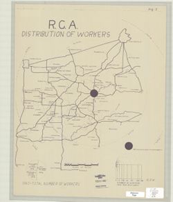
- Subject:
- Topical Subject: Labor supply, Geographic Subject: Bloomington Region (Ind.), and Geographic Subject: Indiana
- Publisher:
- [publisher not identified]
- Date Created:
- 1950
- Identifier:
- VAC3073-M-00074
- Genre:
- Thematic maps
- Geographic Location:
- Coordinates: W0872600 W0855400 N0394700 N0381800
- Related URL:
- Catalog URL: https://iucat.iu.edu/catalog/5296429
- Abstract:
- Blue line print. Shows numbers of R.C.A. Bloomington employees by home cities and towns with graduated circles. Includes graphs. Shows numbers of R.C.A. B...
- Call Number:
- G4094 .B5G8 1950 .R3
- Caption:
- Imprint: [place of publication not identified] : [publisher not identified], [between 1950 and 1969?]
- Physical Description:
- Scale: Approximately 1:500,000 and Dimensions: 46 x 36 cm
- Alternate Identifier:
- Title Control Number: a5296429
- Persistent URL:
- https://purl.dlib.indiana.edu/iudl/images/VAC3073/VAC3073-M-00074
-
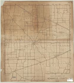
- Subject:
- Geographic Subject: Hendricks County (Ind.), Topical Subject: Roads, and Topical Subject: Bridges
- Publisher:
- [publisher not identified]
- Date Created:
- 1922
- Identifier:
- VAC3073-M-00968
- Genre:
- Road maps
- Geographic Location:
- Coordinates: W0864143 W0861931 N0395527 N0393602
- Related URL:
- Catalog URL: https://iucat.iu.edu/catalog/6946082
- Abstract:
- Brown line. "1922."
- Call Number:
- G4093.H5P2 1922 .R63
- Caption:
- Imprint: [Place of publication not identified] : [publisher not identified], 1922.
- Physical Description:
- Dimensions: 108 x 98 cm and Scale: 1:35,000
- Alternate Identifier:
- Title Control Number: a6946082
- Persistent URL:
- https://purl.dlib.indiana.edu/iudl/images/VAC3073/VAC3073-M-00968
-
![[Northeastern Indiana lake district]](https://iiif.uits.iu.edu/iiif/2/cz30qw21c%2Ffiles%2F3493d108-c2f1-4bc6-aa3b-be11a048abf3/full/250,/0/default.jpg)
- Subject:
- Geographic Subject: Indiana
- Creator:
- McKean, Hugh K.
- Publisher:
- [publisher not identified]
- Date Created:
- 1934
- Identifier:
- VAC3073-M-01287
- Genre:
- Maps
- Geographic Location:
- Coordinates: W0860140 W0844748 N0414530 N0410328
- Related URL:
- Catalog URL: https://iucat.iu.edu/catalog/6946129
- Abstract:
- Blue line. Title supplied by cataloger. Covers an area from the Michigan state line on the north, Fort Wayne on the south, Atwood, Ind. on the west a...
- Call Number:
- G4090 1934 .M35
- Caption:
- Imprint: [Place of publication not identified] : [publisher not identified], [1934]
- Physical Description:
- Dimensions: 68 x 81 cm and Scale: Scale not given.
- Persistent URL:
- https://purl.dlib.indiana.edu/iudl/images/VAC3073/VAC3073-M-01287
-
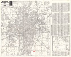
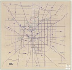
- Subject:
- Geographic Subject: Indianapolis Metropolitan Area (Ind.) and Geographic Subject: Indianapolis (Ind.)
- Creator:
- Metro Graphic Arts
- Publisher:
- [publisher not identified]
- Date Created:
- 1975
- Identifier:
- VAC3073-M-00864
- Genre:
- Maps
- Geographic Location:
- Coordinates: W0861941 W0855614 N0395538 N0393755
- Related URL:
- Catalog URL: https://iucat.iu.edu/catalog/5322622
- Abstract:
- Plastic index device in pocket. Includes indexes, A-C of street index on attached sheet and "Inset map of adjacent areas in Johnson County."
- Call Number:
- G4094 .I4 1975 .M4
- Caption:
- Imprint: Grand Rapids, Mich. : [publisher not identified], 1975.
- Physical Description:
- Dimensions: 128 x 119 cm and Scale: 1:29,000
- Alternate Identifier:
- Title Control Number: a5322622
- Persistent URL:
- https://purl.dlib.indiana.edu/iudl/images/VAC3073/VAC3073-M-00864
-
- Subject:
- Topical Subject: Landowners, Topical Subject: Real property, and Geographic Subject: Monroe County (Ind.)
- Creator:
- Stapleton, John T. (John Tracy)
- Publisher:
- [publisher not identified]
- Date Created:
- 1950
- Identifier:
- VAC3073-M-00331
- Genre:
- Cadastral maps
- Geographic Location:
- Coordinates: W0864100 W0861900 N0392100 N0390000
- Related URL:
- Catalog URL: https://iucat.iu.edu/catalog/5044576
- Abstract:
- Blue line print. Cadastral map showing landowners. "1950."
- Call Number:
- G4093.M7 G46 1950 .S73
- Caption:
- Imprint: [Bloomington, Ind.?] : [publisher not identified], 1950.
- Physical Description:
- Dimensions: 127 x 99 cm and Scale: 1:63,360
- Alternate Identifier:
- Title Control Number: a5044576
- Persistent URL:
- https://purl.dlib.indiana.edu/iudl/images/VAC3073/VAC3073-M-00331
-
- Subject:
- Geographic Subject: Indiana and Topical Subject: Administrative and political divisions
- Publisher:
- [publisher not identified]
- Date Created:
- Circa 1930
- Identifier:
- VAC3073-M-00010
- Genre:
- Thematic maps
- Geographic Location:
- Coordinates: W0880500 W0844700 N0414500 N0374600
- Related URL:
- Catalog URL: https://iucat.iu.edu/catalog/8087637
- Abstract:
- "R." Shows counties, county seats, rivers and railroads.
- Call Number:
- G4091.F7 1930 .M37
- Caption:
- Imprint: Indianapolis, Ind.? : [publisher not identified], 1930?
- Physical Description:
- Dimensions: 47 x 32 cm and Scale: 1:1,000,000
- Alternate Identifier:
- Title Control Number: a8087637
- Persistent URL:
- https://purl.dlib.indiana.edu/iudl/images/VAC3073/VAC3073-M-00010
-
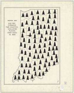
- Subject:
- Topical Subject: Age distribution (Demography), Topical Subject: Sex distribution (Demography), and Geographic Subject: Indiana
- Creator:
- Hart, John Fraser
- Publisher:
- [publisher not identified]
- Date Created:
- 1950
- Identifier:
- VAC3073-M-00337
- Genre:
- Thematic maps
- Geographic Location:
- Coordinates: W0880500 W0844700 N0414500 N0374600
- Related URL:
- Catalog URL: https://iucat.iu.edu/catalog/6083935
- Abstract:
- "JFH." Pen and ink. Includes an age-sex pyramid for each of Indiana's 92 counties. Also appeared as figure 4 in John Fraser Hart. Age pyramids ...
- Call Number:
- G4091.E24 1950 .H37
- Caption:
- Imprint: [place of publication not identified] : [publisher not identified], 1950.
- Physical Description:
- Dimensions: 62 x 45 cm and Scale: Scale not given.
- Alternate Identifier:
- Title Control Number: a6083935
- Persistent URL:
- https://purl.dlib.indiana.edu/iudl/images/VAC3073/VAC3073-M-00337
-
- Subject:
- Geographic Subject: Bloomington (Ind.)
- Creator:
- Bloomington Chamber of Commerce (Bloomington, Ind.)
- Publisher:
- [publisher not identified]
- Date Created:
- 1965
- Identifier:
- VAC3073-M-00683
- Genre:
- Maps
- Geographic Location:
- Coordinates: W0863532 W0862816 N0391315 N0390716
- Related URL:
- Catalog URL: https://iucat.iu.edu/catalog/5301052
- Abstract:
- Indexed. On verso: Monroe County, Indiana.
- Call Number:
- G4094.B5 1965 .B52
- Caption:
- Imprint: Bloomington : [publisher not identified], [1965?]
- Physical Description:
- Dimensions: 43 x 48 cm and Scale: 1:22,000
- Alternate Identifier:
- Title Control Number: a5301052
- Persistent URL:
- https://purl.dlib.indiana.edu/iudl/images/VAC3073/VAC3073-M-00683
-
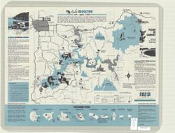
- Subject:
- Geographic Subject: Monroe, Lake (Ind.), Topical Subject: Lakes, and Topical Subject: Reservoirs
- Creator:
- Guide Art Co.
- Publisher:
- [publisher not identified]
- Date Created:
- 1971
- Identifier:
- VAC3073-M-00207
- Genre:
- Tourist maps and Pictorial maps
- Geographic Location:
- Coordinates: W0863238 W0861207 N0391240 N0385806
- Related URL:
- Catalog URL: https://iucat.iu.edu/catalog/5301880
- Abstract:
- Folded title: Tourist guide to Lake Monroe, Indiana's largest lake. Includes text, recreation information, and 9 recreation area maps. Advertisements...
- Call Number:
- G4092.M6E635 1971 .G8
- Caption:
- Imprint: Bloomington, Ind. : [publisher not identified], [1971]
- Physical Description:
- Dimensions: 43 x 56 cm and Scale: 1:80,000
- Alternate Identifier:
- Title Control Number: a5301880
- Persistent URL:
- https://purl.dlib.indiana.edu/iudl/images/VAC3073/VAC3073-M-00207
-
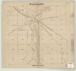
- Subject:
- Geographic Subject: Elkhart (Elkhart County, Ind. : Township)
- Publisher:
- [publisher not identified]
- Date Created:
- 1878
- Identifier:
- VAC3073-M-00591
- Genre:
- Maps
- Geographic Location:
- Coordinates: W0855312 W0854612 N0413632 N0413120
- Related URL:
- Catalog URL: https://iucat.iu.edu/catalog/4659548
- Abstract:
- Shows roads, railroads, section numbers, lakes, rivers, and towns. "T.36 N.R. 6 E." Accompanied by: Index of roads, Elkhart Township, Elkhart Count...
- Call Number:
- G4094 .E614 1878 .E45
- Caption:
- Imprint: [Place of publication not identified] : [publisher not identified], [1878]
- Physical Description:
- Dimensions: 56 x 60 cm and Scale: 1:19,600
- Alternate Identifier:
- Title Control Number: CAF4746BB
- Persistent URL:
- https://purl.dlib.indiana.edu/iudl/images/VAC3073/VAC3073-M-00591
-
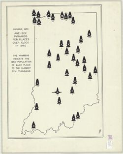
- Subject:
- Topical Subject: Sex distribution (Demography), Geographic Subject: Indiana, Topical Subject: Cities and towns, and Topical Subject: Age distribution (Demogr...
- Creator:
- Hart, John Fraser
- Publisher:
- [publisher not identified]
- Date Created:
- 1950
- Identifier:
- VAC3073-M-00746
- Genre:
- Thematic maps
- Geographic Location:
- Coordinates: W0880500 W0844700 N0414500 N0374600
- Related URL:
- Catalog URL: https://iucat.iu.edu/catalog/6086983
- Abstract:
- "JFH." "The numbers indicate the 1950 population of each place to the closest ten thousand." Includes an age-sex pyramid for each of the ...
- Call Number:
- G4091.E24 1950 .H378
- Caption:
- Imprint: [Place of publications not identified] : [publisher not identified], [195-?]
- Physical Description:
- Scale: Scale not given. and Dimensions: 64 x 45 cm
- Alternate Identifier:
- Title Control Number: a6086983
- Persistent URL:
- https://purl.dlib.indiana.edu/iudl/images/VAC3073/VAC3073-M-00746
-
- Subject:
- Geographic Subject: Clinton (Ind.), Geographic Subject: Eugene (Ind.), Topical Subject: Railroads, Topical Subject: Landowners, Geographic Subject: Newport (...
- Creator:
- Tarrance, James
- Publisher:
- [publisher not identified]
- Date Created:
- 1872
- Identifier:
- VAC3073-M-00785
- Genre:
- Cadastral maps
- Geographic Location:
- Coordinates: W0873200 W0872300 N0400900 N0393700
- Related URL:
- Catalog URL: https://iucat.iu.edu/catalog/4685613
- Abstract:
- Cadastral map showing landowners. Shows Commissioners Districts. Includes maps of Perrysville, Eugene, Newport, railroads of Indiana, and Clinton and drawing...
- Call Number:
- G4093 .V4G46 1872 .T37
- Caption:
- Imprint: [Place of publication not identified] : [publisher not identified], 1872.
- Physical Description:
- Scale: 1:42,240 and Dimensions: 148 x 61 cm, pieces 51 x 65 and 52 x 65 cm
- Alternate Identifier:
- Title Control Number: CAV8552BB
- Persistent URL:
- https://purl.dlib.indiana.edu/iudl/images/VAC3073/VAC3073-M-00785
-
![[Bloomington, Indiana, cadastral map]](https://iiif.uits.iu.edu/iiif/2/0r9686792%2Ffiles%2F47529974-267a-4ca2-bcce-8ead7355fbf3/full/250,/0/default.jpg)
- Subject:
- Topical Subject: Real property and Geographic Subject: Bloomington (Ind.)
- Publisher:
- [publisher not identified]
- Date Created:
- 1980
- Identifier:
- VAC3073-M-00306
- Genre:
- Cadastral maps
- Geographic Location:
- Coordinates: W0863532 W0862816 N0391315 N0390716
- Related URL:
- Catalog URL: https://iucat.iu.edu/catalog/5300699
- Abstract:
- Blue line print. Cadastral map. Title supplied by cataloger. Each sheet is 1/4 section.
- Call Number:
- G4094.B5 G46 s1 .B5
- Caption:
- Imprint: [Bloomington, Ind.?] : [publisher not identified], [198-?]
- Physical Description:
- Dimensions: on sheets 84 x 84 cm or smaller. and Scale: 1:1,200
- Alternate Identifier:
- Title Control Number: a5300699
- Persistent URL:
- https://purl.dlib.indiana.edu/iudl/images/VAC3073/VAC3073-M-00306
-
![Bloomington, [Indiana] metropolitan map series](https://iiif.uits.iu.edu/iiif/2/vd66x2473%2Ffiles%2F73a8eae4-4788-4585-b937-b6e45ec91e24/full/250,/0/default.jpg)
- Subject:
- Geographic Subject: Bloomington Metropolitan Area (Ind.), Geographic Subject: Ellettsville (Ind.), Geographic Subject: Monroe County (Ind.), Geographic Subje...
- Creator:
- United States. Bureau of the Census. Geography Division
- Publisher:
- [publisher not identified]
- Date Created:
- 1967
- Identifier:
- VAC3073-M-00170
- Genre:
- Statistical maps, Thematic maps, and Census data
- Geographic Location:
- Coordinates: W0863904 W0860450 N0391839 N0390254
- Related URL:
- Catalog URL: https://iucat.iu.edu/catalog/5326785
- Abstract:
- Blue line print. "1020." "1980 census map." Shows census blocks for portions of Monroe County, Indiana, including Bloomington, Ellettsvi...
- Call Number:
- G4094.B5 E25 s19 .U5
- Caption:
- Imprint: [place of publication not identified : publisher not identified, 198-?]
- Physical Description:
- Scale: 1:19,000 and Dimensions: 37 x 57 cm
- Alternate Identifier:
- Title Control Number: a5326785
- Persistent URL:
- https://purl.dlib.indiana.edu/iudl/images/VAC3073/VAC3073-M-00170
