
Search Constraints
You searched for:
Publisher
Indiana. Geological Survey
Remove constraint Publisher: Indiana. Geological Survey
1 - 77 of 77
Search Results
-
- Subject:
- Topical Subject: IGS Annual Reports and Geographic Subject: Indiana
- Publisher:
- Indiana. Geological Survey
- Date Created:
- 1875
- Identifier:
- VAC3073-M-01173
- Genre:
- Geological cross-sections
- Related URL:
- Catalog URL: https://iucat.iu.edu/catalog/4022269
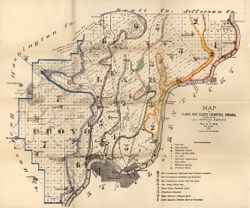
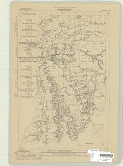
- Abstract:
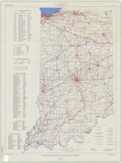
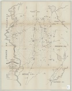
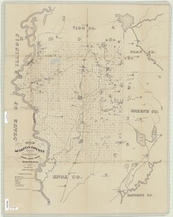
- Lawrence Co.
- Call Number:
- QE109 . A2 1874 map p42
- Caption:
- Imprint: Indianapolis : 1875.
- Physical Description:
- Dimensions: 21 x 34 cm.
- Persistent URL:
- https://purl.dlib.indiana.edu/iudl/images/VAC3073/VAC3073-M-01173
- Provenance:
- 6th Annual Report (1874) / Indiana. Geological Survey.
-
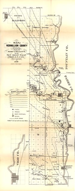
- Subject:
- Geographic Subject: Vanderburgh County (Ind.), Topical Subject: Coal mines and mining, Topical Subject: Mines and mineral resources, Topical Subject: Geology...
- Creator:
- Collett, John, 1828-1899
- Publisher:
- Indiana. Geological Survey
- Date Created:
- 1876
- Identifier:
- VAC3073-M-01146
- Genre:
- Geological maps
- Geographic Location:
- Coordinates: W0874203 W0872658 N0381006 N0374933
- Related URL:
- Catalog URL: https://iucat.iu.edu/catalog/18349316
- Abstract:
- Compiled for the 7th annual report of E.T. Cox, State Geologist , geology by Prof. John Collett, 1875. Relief shown by hachures. Shows cities and towns, rail...
- Call Number:
- G4093.V3C5 1875 .C6
- Caption:
- Imprint: [Indianapolis] : [Geological Survey of Indiana], [1876] and Imprint: [Indianapolis] : [Sentinel Company, printers], [1876]
- Physical Description:
- Scale: Approximately 1:130,000 and Dimensions: on sheet 41 x 31 cm
- Alternate Identifier:
- Alternate ID: 390723IP and Title Control Number: a18349316
- Persistent URL:
- https://purl.dlib.indiana.edu/iudl/images/VAC3073/VAC3073-M-01146
- Provenance:
- 7th Annual Report (1875) / Indiana. Geological Survey.
-
- Subject:
- Topical Subject: Mines and mineral resources, Geographic Subject: Greene County (Ind.), and Topical Subject: IGS Annual Reports
- Creator:
- Levette, G. M. (Gilbert M.)
- Publisher:
- Indiana. Geological Survey
- Date Created:
- 1869
- Identifier:
- VAC3073-M-01449
- Genre:
- Thematic maps
- Geographic Location:
- Coordinates: W0871431 W0864053 N0391018 N0385418
- Related URL:
- Catalog URL: https://iucat.iu.edu/catalog/18189063
- Abstract:
- Shows towns, railroads, coal and iron ore, mills, furnaces, and stone quarries. "For the first annual report of Prof. E.T. Cox, State Geologist." ...
- Call Number:
- G4093.G7H1 1869 .L3
- Caption:
- Imprint: [Indianapolis] : [Alexander M. Conner], [1869]
- Physical Description:
- Dimensions: 61 x 71 cm and Scale: Approximately 1:85,000
- Alternate Identifier:
- Title Control Number: a18189063
- Persistent URL:
- https://purl.dlib.indiana.edu/iudl/images/VAC3073/VAC3073-M-01449
- Provenance:
- 1st Annual Report (1869) / Indiana. Geological Survey
-
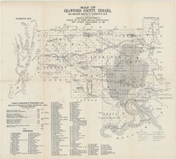
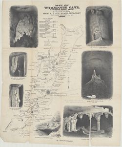
- Subject:
- Topical Subject: IGS Annual Reports, Topical Subject: Coal mines and mining, Geographic Subject: Crawford County (Ind.), Geographic Subject: Wyandotte Cave (...
- Creator:
- Collett, John, 1828-1899
- Publisher:
- Indiana. Geological Survey
- Date Created:
- 1879
- Identifier:
- VAC3073-M-01546
- Genre:
- Thematic maps
- Geographic Location:
- Coordinates: W0863746 W0861445 N0382324 N0380600
- Related URL:
- Catalog URL: https://iucat.iu.edu/catalog/18349479
- Abstract:
- Prepared for 10th annual report of Prof. E.T. Cox, State Geologist by John Collett, 1878. Relief shown by hachures. Shows cities and towns, railroads, cavern...
- Call Number:
- G4093.C7C5 1878 .C6
- Caption:
- Imprint: [Indianapolis] : [Geological Survey of Indiana], [1879] and Imprint: [Indianapolis] : [Indianapolis Journal Company, State printers], [1879]
- Physical Description:
- Scale: Approximately 1:125,000 and Dimensions: on sheet 39 x 44 cm
- Alternate Identifier:
- Title Control Number: a18349479 and Alternate ID: 390723IP
- Persistent URL:
- https://purl.dlib.indiana.edu/iudl/images/VAC3073/VAC3073-M-01546
- Provenance:
- 8th, 9th, and 10th Annual Reports (1876, 1877, 1878) / Indiana. Geological Survey.
-
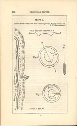
- Subject:
- Geographic Subject: Cambridge City (Ind.), Topical Subject: Henges, and Topical Subject: IGS Annual Reports
- Creator:
- Macpherson, J. C. (John C.)
- Publisher:
- Indiana. Geological Survey
- Date Created:
- 1879
- Identifier:
- VAC3073-M-01551
- Genre:
- Pictorial maps
- Geographic Location:
- Coordinates: W0851016 W0851004 N0395012 N0395001
- Related URL:
- Catalog URL: https://iucat.iu.edu/catalog/18387638
- Abstract:
- At head of title: Plate A. Relief shown by profile and spot heights. Includes pictorial map of west branch of Whitewater River and three figures showing heig...
- Call Number:
- G4094.C15E15 1878 .M33
- Caption:
- Imprint: [Indianapolis] : [Indianapolis Journal Company, State printers], [1879] and Imprint: [Indianapolis] : [Geological Survey of Indiana], [1879]
- Physical Description:
- Dimensions: on sheet 22 x 13 cm and Scale: Approximately 1:2,400. 1 inch = 200 ft.
- Alternate Identifier:
- Alternate ID: 390723IP and Title Control Number: a18387638
- Persistent URL:
- https://purl.dlib.indiana.edu/iudl/images/VAC3073/VAC3073-M-01551
- Provenance:
- 8th, 9th, and 10th Annual Reports (1876, 1877, 1878) / Indiana. Geological Survey.
-
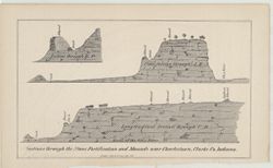
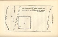
- Subject:
- Topical Subject: Stone walls, Geographic Subject: Clark County (Ind.), Topical Subject: Mounds, and Topical Subject: Fortification
- Publisher:
- Indiana. Geological Survey
- Date Created:
- 1873
- Identifier:
- VAC3073-M-01543
- Genre:
- Geological cross-sections and Pictorial maps
- Geographic Location:
- Coordinates: W0853723 W0853635 N0382605 N0382513
- Related URL:
- Catalog URL: https://iucat.iu.edu/catalog/18318650
- Abstract:
- 3 sections on 1 sheet. Relief shown by profile. Detached from: Geology report. In Fifth annual report of the Geological Survey of Indiana, made in the yea...
- Call Number:
- G4093.C4R4 1873 .S43
- Caption:
- Imprint: [Indianapolis] : [Geological Survey of Indiana], [1874] and Imprint: [Indianapolis] : [Sentinel Co., printers], [1874]
- Physical Description:
- Scale: Scale not given. and Dimensions: on sheet 14 x 22 cm
- Alternate Identifier:
- Title Control Number: a18318650 and Alternate ID: 390723IP
- Persistent URL:
- https://purl.dlib.indiana.edu/iudl/images/VAC3073/VAC3073-M-01543
- Provenance:
- 5th Annual Report (1873) / Indiana. Geological Survey.
-
- Subject:
- Topical Subject: Subsurface drainage, Topical Subject: Groundwater, Geographic Subject: Indiana, and Topical Subject: Pollution
- Creator:
- Frushour, Samuel S.
- Publisher:
- Indiana. Geological Survey
- Date Created:
- 2000
- Identifier:
- VAC3073-M-00844
- Genre:
- Thematic maps
- Geographic Location:
- Coordinates: W0865700 W0855900 N0393800 N0375400
- Related URL:
- Catalog URL: https://iucat.iu.edu/catalog/4898418
- Abstract:
- Digital cartogrpahy by Kimberly H. Sowder." Includes index map and text: Abstract and "Sources of subsurface dye trace information."
- Call Number:
- G4091 .C34 2000 .F7
- Caption:
- Imprint: Bloomington, Ind. : Indiana Geological Survey, 2000.
- Physical Description:
- Dimensions: 19 x 19 cm or smaller, on sheet 58 x 92 cm and Scale: 1:500,000
- Alternate Identifier:
- Title Control Number: a4898418
- Persistent URL:
- https://purl.dlib.indiana.edu/iudl/images/VAC3073/VAC3073-M-00844
-
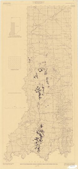
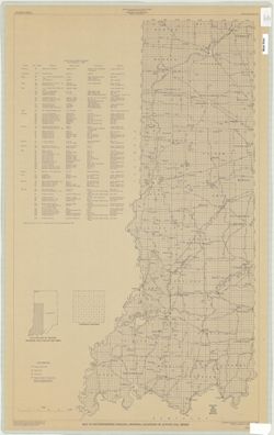
- Subject:
- Geographic Subject: Warren County (Ind.), Topical Subject: Coal mines and mining, Geographic Subject: Vermillion County (Ind.), and Geographic Subject: Fount...
- Creator:
- Hutchison, Harold C. (Harold Christy), 1925-
- Publisher:
- Indiana. Geological Survey
- Date Created:
- 1961
- Identifier:
- VAC3073-M-00418
- Genre:
- Mine maps
- Geographic Location:
- Coordinates: W0873200 W0870533 N0402800 N0395645
- Related URL:
- Catalog URL: https://iucat.iu.edu/catalog/4898738
- Abstract:
- "Preliminary coal map no. 9"--Margin. Includes 1 ancillary map, 1 diagram showing township enumeration, 1 index map, 1 stratigraphic column, and 1 ...
- Call Number:
- G4093.F6H9 1961 .H88
- Caption:
- Imprint: Bloomington : Indiana Dept. of Conservation, Geological Survey, 1961.
- Physical Description:
- Scale: Scales differ. and Dimensions: 61 x 72 cm
- Alternate Identifier:
- Title Control Number: a4898738
- Persistent URL:
- https://purl.dlib.indiana.edu/iudl/images/VAC3073/VAC3073-M-00418
-
- Subject:
- Topical Subject: Geology, Geographic Subject: Clark County (Ind.), Topical Subject: Mines and mineral resources, Geographic Subject: Floyd County (Ind.), and...
- Creator:
- Cox, E. T. (Edward Travers), 1821-1907 and Borden, W. W. (William Wesley), 1823-1906
- Publisher:
- Indiana. Geological Survey
- Date Created:
- 1874
- Identifier:
- VAC3073-M-01155
- Genre:
- Geological maps
- Geographic Location:
- Coordinates: W0860258 W0852426 N0383636 N0380900
- Related URL:
- Catalog URL: https://iucat.iu.edu/catalog/18318611
- Abstract:
- Prepared for the 5th annual report of Prof. E.T. Cox, State Geologist, 1873 , geology by W.W. Borden. Relief shown by hachures. Shows cities and towns, railr...
- Call Number:
- G4093.C4C5 1873 .B6
- Caption:
- Imprint: [Indianapolis] : [Geological Survey of Indiana], [1874] and Imprint: [Indianapolis] : [Sentinel Co., printers], [1874]
- Physical Description:
- Dimensions: on sheet 41 x 49 cm and Scale: Approximately 1:130,000
- Alternate Identifier:
- Alternate ID: 390723IP and Title Control Number: a18318611
- Persistent URL:
- https://purl.dlib.indiana.edu/iudl/images/VAC3073/VAC3073-M-01155
- Provenance:
- 5th Annual Report (1873) / Indiana. Geological Survey.
-
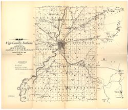
- Subject:
- Topical Subject: IGS Annual Reports, Topical Subject: Coal mines and mining, Topical Subject: Lumber trade, Geographic Subject: Vigo County (Ind.), Topical S...
- Creator:
- Collett, John, 1828-1899
- Publisher:
- Indiana. Geological Survey
- Date Created:
- 1869
- Identifier:
- VAC3073-M-01158
- Genre:
- Geological maps
- Geographic Location:
- Coordinates: W0873159 W0872113 N0400854 N0393626
- Related URL:
- Catalog URL: https://iucat.iu.edu/catalog/16799192
- Abstract:
- Drawn by John Collett for the 1st annual report of Prof. E.T. Cox, State Geologist, 1869 , lith. by W & J. Braden. Shows towns, railroads, coal, mills...
- Call Number:
- G4093.V4 1869 .C6
- Caption:
- Imprint: [Indianapolis] : [Alexander H. Conner, State Printer], [1869] and Imprint: [Indianapolis] : [Geological Survey of Indiana], [1869]
- Physical Description:
- Dimensions: on sheet 77 x 32 cm and Scale: Approximately 1:85,000. 3/4 of an inch to one mile
- Alternate Identifier:
- Title Control Number: a16799192 and Alternate ID: 390720IP
- Persistent URL:
- https://purl.dlib.indiana.edu/iudl/images/VAC3073/VAC3073-M-01158
- Provenance:
- 1st Annual Report (1869) / Indiana. Geological Survey
-
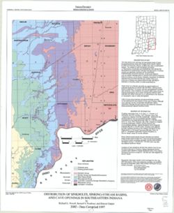
- Subject:
- Topical Subject: Caves, Geographic Subject: Indiana, Topical Subject: Springs, Topical Subject: Sinkholes, and Topical Subject: Karst
- Creator:
- Powell, Richard L.
- Publisher:
- Indiana. Geological Survey
- Date Created:
- 2002
- Identifier:
- VAC3073-M-00135
- Genre:
- Geological maps
- Geographic Location:
- Coordinates: W0870002 W0854608 N0394722 N0375826
- Related URL:
- Catalog URL: https://iucat.iu.edu/catalog/5325676
- Abstract:
- "This map data was compiled in 1997 from information available at the time, but was unpublished until until 2002, the map does not reflect any changes i...
- Call Number:
- G4091.C28 1997 .P69
- Caption:
- Imprint: [Bloomington, Ind.] : Indiana Geological Survey, 2002.
- Physical Description:
- Scale: 1:250,000 and Dimensions: 82 x 42 cm
- Alternate Identifier:
- Title Control Number: a5325676
- Persistent URL:
- https://purl.dlib.indiana.edu/iudl/images/VAC3073/VAC3073-M-00135
-
- Subject:
- Topical Subject: Coal mines and mining and Geographic Subject: Indiana
- Creator:
- Hutchison, Harold C. (Harold Christy), 1925-
- Publisher:
- Indiana. Geological Survey
- Date Created:
- 1974
- Identifier:
- VAC3073-M-00711
- Genre:
- Thematic maps and Mine maps
- Geographic Location:
- Coordinates: W0880100 W0862800 N0403900 N0374500
- Related URL:
- Catalog URL: https://iucat.iu.edu/catalog/5046466
- Abstract:
- Blue line print. "Base modified from Indiana Department of Conservation, Geological Survey. Base map of portion of western Indiana, 1951." Includes...
- Call Number:
- G4091 .H9 1974 .H8
- Caption:
- Imprint: [Bloomington, Ind.] : Indiana Dept. of Conservation, Geological Survey, [1974]
- Physical Description:
- Scale: 1:325,000 and Dimensions: 88 x 54 cm
- Alternate Identifier:
- Title Control Number: a5046466
- Persistent URL:
- https://purl.dlib.indiana.edu/iudl/images/VAC3073/VAC3073-M-00711
-
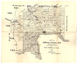
- Subject:
- Topical Subject: IGS Annual Reports, Topical Subject: Real property, Geographic Subject: Jefferson County (Ind.), and Topical Subject: Landowners
- Creator:
- Borden, W. W. (William Wesley), 1823-1906
- Publisher:
- Indiana. Geological Survey
- Date Created:
- 1875
- Identifier:
- VAC3073-M-01172
- Genre:
- Cadastral maps
- Geographic Location:
- Coordinates: W0853944 W0851048 N0385447 N0383436
- Related URL:
- Catalog URL: https://iucat.iu.edu/catalog/18318691
- Abstract:
- Prepared for the sixth annual report of E.T. Cox, State Geologist, geology by W.W. Borden. Relief shown by hachures. Shows cities and towns, railroads, and l...
- Call Number:
- G4093.J5C5 1874 .B6
- Caption:
- Imprint: [Indianapolis, Indiana] : [Sentinel Co., printers], [1875] and Imprint: [Indianapolis] : [Geological Survey of Indiana], [1875]
- Physical Description:
- Dimensions: 40 x 35 cm, on sheet 39 x 47 cm and Scale: Approximately 1:130,000
- Alternate Identifier:
- Alternate ID: 390723IP and Title Control Number: a18318691
- Persistent URL:
- https://purl.dlib.indiana.edu/iudl/images/VAC3073/VAC3073-M-01172
- Provenance:
- 6th Annual Report (1874) / Indiana. Geological Survey.
-
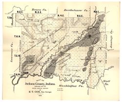
- Subject:
- Geographic Subject: Jackson County (Ind.), Topical Subject: Geology, and Topical Subject: IGS Annual Reports
- Creator:
- Cox, E. T. (Edward Travers), 1821-1907
- Publisher:
- Indiana. Geological Survey
- Date Created:
- 1875
- Identifier:
- VAC3073-M-01177
- Genre:
- Geological maps
- Geographic Location:
- Coordinates: W0861905 W0854741 N0390414 N0384329
- Related URL:
- Catalog URL: https://iucat.iu.edu/catalog/18318685
- Abstract:
- Prepared for the sixth annual report of E[.]T. Cox, State Geologist, 1874. Relief shown by hachures. Shows cities and towns, railroads, geology of the region...
- Call Number:
- G4093.J2C5 1874 .C6
- Caption:
- Imprint: [Indianapolis] : [Geological Survey of Indiana], [1875] and Imprint: [Indianapolis] : [Sentinel Co., printers], [1875]
- Physical Description:
- Scale: Approximately 1:130,000 and Dimensions: on sheet 40 x 47 cm
- Alternate Identifier:
- Title Control Number: a18318685 and Alternate ID: 390723IP
- Persistent URL:
- https://purl.dlib.indiana.edu/iudl/images/VAC3073/VAC3073-M-01177
- Provenance:
- 6th Annual Report (1874) / Indiana. Geological Survey.
-
- Subject:
- Geographic Subject: Indiana, Topical Subject: Geology, Stratigraphic, Geographic Subject: Ohio, and Topical Subject: Geology
- Creator:
- Schneider, Allan F. (Allan Frank), 1926-, Gooding, Ansel Miller, Forsyth, Jane L. (Jane Louise), 1921-, Gray, Henry Hamilton, 1922-, and Indiana. Geological ...
- Publisher:
- Indiana. Geological Survey
- Date Created:
- 1972
- Identifier:
- VAC3073-M-01245
- Genre:
- Geological maps, Geological cross-sections, and Quadrangle maps
- Geographic Location:
- Coordinates: W0860000 W0840000 N0400000 N0390000
- Related URL:
- Catalog URL: https://iucat.iu.edu/catalog/16799790
- Abstract:
- By Henry H. Gray, Jane L. Forsyth, Allan F. Schneider, and Ansel M. Gooding. Transverse Mercator projection. "Base map modified from Army Map Service, M...
- Call Number:
- G4091 .C5 1972 .G455
- Caption:
- Imprint: [Bloomington, Ind.] : Indiana Geological Survey, 1972
- Physical Description:
- Dimensions: 73 x 66 cm and Scale: 1:250,000
- Alternate Identifier:
- Title Control Number: a16799790
- Persistent URL:
- https://purl.dlib.indiana.edu/iudl/images/VAC3073/VAC3073-M-01245
- Provenance:
- Indiana. Geological Survey. Regional geologic map , no. 7.
-
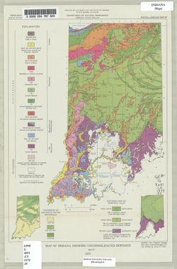
- Subject:
- Topical Subject: Sediments (Geology), Topical Subject: Geology, and Geographic Subject: Indiana
- Creator:
- Indiana. Geological Survey
- Publisher:
- Indiana. Geological Survey
- Date Created:
- 1979
- Identifier:
- VAC3073-M-00675
- Genre:
- Geological maps
- Geographic Location:
- Coordinates: W0880500 W0844700 N0414500 N0374600
- Related URL:
- Catalog URL: https://iucat.iu.edu/catalog/4459811
- Abstract:
- "Modified from Regional Geologic Map Series, Indiana Geological Survey." Includes insets of "Thickness of unconsolidated materials" and &...
- Call Number:
- G4091 .C5 1979 .I5
- Caption:
- Imprint: [Bloomington, Ind.] : The Survey, 1979.
- Physical Description:
- Dimensions: 31 x 22 cm and Scale: 1:1,900,000
- Alternate Identifier:
- Title Control Number: a4459811
- Persistent URL:
- https://purl.dlib.indiana.edu/iudl/images/VAC3073/VAC3073-M-00675
-
- Subject:
- Topical Subject: Karst, Topical Subject: Sinkholes, Geographic Subject: Indiana, and Topical Subject: Caves
- Creator:
- Powell, Richard L.
- Publisher:
- Indiana. Geological Survey
- Date Created:
- 2002
- Identifier:
- VAC3073-M-00789
- Genre:
- Geological maps
- Geographic Location:
- Coordinates: W0854940 W0845820 N0392712 N0384033
- Related URL:
- Catalog URL: https://iucat.iu.edu/catalog/5325528
- Abstract:
- "This map data was compiled in 1997 from information available at the time, but was unpublished until until 2002, the map does not reflect any changes i...
- Call Number:
- G4091.C28 1997 .P694
- Caption:
- Imprint: [Bloomington, Ind.] : Indiana Geological Survey, 2002.
- Physical Description:
- Dimensions: 54 x 49 cm and Scale: 1:250,000
- Alternate Identifier:
- Title Control Number: a5325528
- Persistent URL:
- https://purl.dlib.indiana.edu/iudl/images/VAC3073/VAC3073-M-00789
-
- Subject:
- Geographic Subject: Indiana and Topical Subject: Geology
- Creator:
- Patton, John B. (John Barratt), 1915-
- Publisher:
- Indiana. Geological Survey
- Date Created:
- 1951
- Identifier:
- VAC3073-M-00349
- Genre:
- Geological maps
- Geographic Location:
- Coordinates: W0873622 W0844704 N0400224 N0374618
- Related URL:
- Catalog URL: https://iucat.iu.edu/catalog/6232196
- Abstract:
- Blue line. "Not for publication for correspondence use only"-- Upper margin.
- Call Number:
- G4091.C5 1951 .P38
- Caption:
- Imprint: [Bloomington, Ind.] : Indiana Dept. of Conservation, Geological Survey, 1951.
- Physical Description:
- Dimensions: 20 x 26 cm and Scale: Approximately 1:1,500,000
- Alternate Identifier:
- Title Control Number: a6232196
- Persistent URL:
- https://purl.dlib.indiana.edu/iudl/images/VAC3073/VAC3073-M-00349
-
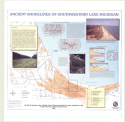
- Subject:
- Geographic Subject: Porter County (Ind.), Geographic Subject: Indiana, Geographic Subject: Michigan, Lake, Coast (Ind.), Topical Subject: Lakes, Topical Subj...
- Creator:
- Thompson, Todd A. (Todd Alan), 1959-
- Publisher:
- Indiana. Geological Survey
- Date Created:
- 2000
- Identifier:
- VAC3073-M-00193
- Genre:
- Thematic maps
- Geographic Location:
- Coordinates: W0873136 W0871307 N0414539 N0410943
- Related URL:
- Catalog URL: https://iucat.iu.edu/catalog/4898581
- Abstract:
- Includes illustrations, text, graphs showing "Lake-level fluctuations over the past 4,700 years" and a timeline showing historical events since 116...
- Call Number:
- G4093 .L3C2 2000 .T486
- Caption:
- Imprint: [Bloomington, Ind.] : Indiana University, Indiana Geological Survey, 2000.
- Physical Description:
- Dimensions: 76 x 87 cm and Scale: 1:59,000
- Alternate Identifier:
- Title Control Number: a4898581
- Persistent URL:
- https://purl.dlib.indiana.edu/iudl/images/VAC3073/VAC3073-M-00193
-
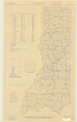
- Subject:
- Topical Subject: Coal preparation plants and Geographic Subject: Indiana
- Creator:
- Eggert, Donald L.
- Publisher:
- Indiana. Geological Survey
- Date Created:
- 1979
- Identifier:
- VAC3073-M-00195
- Genre:
- Mine maps and Thematic maps
- Geographic Location:
- Coordinates: W0880700 W0844500 N0414500 N0375200
- Related URL:
- Catalog URL: https://iucat.iu.edu/catalog/5304756
- Abstract:
- "December 1979".
- Call Number:
- G4091.H9 1979 .E34
- Caption:
- Imprint: [Bloomington, Ind.]: Indiana Geological Survey, 1979.
- Physical Description:
- Dimensions: 67 x 41 cm and Scale: Approximately 1:380,000
- Alternate Identifier:
- Title Control Number: a5304756
- Persistent URL:
- https://purl.dlib.indiana.edu/iudl/images/VAC3073/VAC3073-M-00195
-
- Subject:
- Topical Subject: Administrative and political divisions and Geographic Subject: Indiana
- Creator:
- Moran, W. H. (William H.)
- Publisher:
- Indiana. Geological Survey
- Date Created:
- 1952
- Identifier:
- VAC3073-M-00215
- Genre:
- Maps
- Geographic Location:
- Coordinates: W0880500 W0844700 N0414500 N0374600
- Related URL:
- Catalog URL: https://iucat.iu.edu/catalog/1233088
- Abstract:
- "January 1952." Black line print. "Traced from Map of Indiana, edition of 1950, published by U.S. Geological Survey. Minor revisions and addit...
- Call Number:
- G4091 .A1 1952 .M6
- Caption:
- Imprint: [Indianapolis?] : Geological Survey, 1952
- Physical Description:
- Dimensions: 92 x 59 cm and Scale: 1:500,000
- Alternate Identifier:
- Title Control Number: AKM1618BB
- Persistent URL:
- https://purl.dlib.indiana.edu/iudl/images/VAC3073/VAC3073-M-00215
-
- Subject:
- Topical Subject: Geology, Stratigraphic, Geographic Subject: Michigan, Geographic Subject: Ohio, Topical Subject: Geology, and Geographic Subject: Indiana
- Creator:
- Keller, Stanley J., Johnson, Gerald H., Michigan. Geological Survey, and Indiana. Geological Survey
- Publisher:
- Indiana. Geological Survey
- Date Created:
- 1972
- Identifier:
- VAC3073-M-01249
- Genre:
- Geological maps, Geological cross-sections, and Quadrangle maps
- Geographic Location:
- Coordinates: W0860000 W0840000 N0420000 N0410000
- Related URL:
- Catalog URL: https://iucat.iu.edu/catalog/18455585
- Abstract:
- By Gerald H. Johnson and Stanley J. Keller. transverse Mercator projection. Regional geologic map , no. 8. Relief shown by profile. Includes columnar section...
- Call Number:
- G4091.C5 s250 .I5 Fort Wayne 1972
- Caption:
- Imprint: [Bloomington] : Indiana Geological Survey, 1972
- Physical Description:
- Scale: 1:250,000. Vertical scale approximately 1:1,200 and Dimensions: 66 x 101 cm
- Alternate Identifier:
- Title Control Number: a18455585
- Persistent URL:
- https://purl.dlib.indiana.edu/iudl/images/VAC3073/VAC3073-M-01249
- Provenance:
- Indiana. Geological Survey. Regional geologic map , no. 8.
-
- Subject:
- Geographic Subject: Knox County (Ind.), Topical Subject: Geology, Topical Subject: Mines and mineral resources, Topical Subject: IGS Annual Reports, and Geog...
- Creator:
- Indiana. Geological Survey
- Publisher:
- Indiana. Geological Survey
- Date Created:
- 1874
- Identifier:
- VAC3073-M-01451
- Genre:
- Geological maps
- Related URL:
- Catalog URL: https://iucat.iu.edu/catalog/4022269
- Call Number:
- QE109 .A2 1874
- Caption:
- Imprint: Indianapolis : 1874.
- Persistent URL:
- https://purl.dlib.indiana.edu/iudl/images/VAC3073/VAC3073-M-01451
- Provenance:
- 5th Annual Report (1873) / Indiana. Geological Survey.
-
- Subject:
- Topical Subject: Geology, Stratigraphic, Topical Subject: IGS Annual Reports, Topical Subject: Coal mines and mining, and Geographic Subject: Daviess County ...
- Creator:
- Wright, S. D. (Of Daviess County, Ind.), Levette, G. M. (Gilbert M.), and Cox, E. T. (Edward Travers), 1821-1907
- Publisher:
- Indiana. Geological Survey
- Date Created:
- 1871
- Identifier:
- VAC3073-M-01150
- Genre:
- Geological maps and Geological cross-sections
- Geographic Location:
- Coordinates: W0871105 W0870830 N0384031 N0383833
- Related URL:
- Catalog URL: https://iucat.iu.edu/catalog/18298907
- Abstract:
- Relief shown by contours and profile. Includes index and geological profile. Shows mills, factories, hotels, churches, halls, a brewery, and school houses. P...
- Call Number:
- G4093.D2H9 1871 .W7
- Caption:
- Imprint: [Indianapolis] : [Geological Survey of Indiana], [1871]
- Physical Description:
- Scale: Scale approximately 1:21,000. 3 in. equals 1 mile. Vertical scale approximately 1:925 and Dimensions: 36 x 28 cm
- Alternate Identifier:
- Alternate ID: 390721IP and Title Control Number: a18298907
- Persistent URL:
- https://purl.dlib.indiana.edu/iudl/images/VAC3073/VAC3073-M-01150
- Provenance:
- 2nd Annual Report (1870) / Indiana. Geological Survey.
-
- Subject:
- Topical Subject: Coal mines and mining and Geographic Subject: Indiana
- Creator:
- Powell, Richard L.
- Publisher:
- Indiana. Geological Survey
- Date Created:
- 1972
- Identifier:
- VAC3073-M-00730
- Genre:
- Mine maps
- Geographic Location:
- Coordinates: W0880700 W0844500 N0414500 N0375200
- Related URL:
- Catalog URL: https://iucat.iu.edu/catalog/5346323
- Call Number:
- G4091.H9 1972 .P6
- Caption:
- Imprint: [Bloomington, Ind.] : Indiana Geological Survey, 1972.
- Physical Description:
- Dimensions: 88 x 40 cm and Scale: 1:380,000
- Alternate Identifier:
- Title Control Number: a5346323
- Persistent URL:
- https://purl.dlib.indiana.edu/iudl/images/VAC3073/VAC3073-M-00730
-
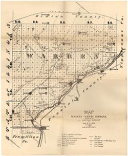
- Subject:
- Topical Subject: Mines and mineral resources, Topical Subject: Geology, Topical Subject: IGS Annual Reports, Geographic Subject: Warren County (Ind.), and To...
- Creator:
- Collett, John, 1828-1899
- Publisher:
- Indiana. Geological Survey
- Date Created:
- 1873
- Identifier:
- VAC3073-M-01171
- Genre:
- Geological maps
- Geographic Location:
- Coordinates: W0873200 W0870600 N0402800 N0400700
- Related URL:
- Catalog URL: https://iucat.iu.edu/catalog/15734000
- Abstract:
- Relief shown by hachures. Shows cities and towns, operating and proposed railroads, prairies, test bores, deposits of iron ore and mill stone grit, mills, qu...
- Call Number:
- G4093.W3C5 1873 .C6
- Caption:
- Imprint: [Indianapolis] : [Sentinel Company, printers], [1874]
- Physical Description:
- Scale: Approximately 1:120,000 and Dimensions: 44 x 36 cm
- Alternate Identifier:
- Title Control Number: a15734000 and Alternate ID: 390723IP
- Persistent URL:
- https://purl.dlib.indiana.edu/iudl/images/VAC3073/VAC3073-M-01171
- Provenance:
- 5th Annual Report (1873) / Indiana. Geological Survey.
-
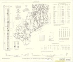
- Subject:
- Geographic Subject: Spencer County (Ind.), Topical Subject: Coal mines and mining, and Topical Subject: Coal
- Creator:
- Hutchison, Harold C. (Harold Christy), 1925-
- Publisher:
- Indiana. Geological Survey
- Date Created:
- 1959
- Identifier:
- VAC3073-M-00222
- Genre:
- Mine maps and Thematic maps
- Geographic Location:
- Coordinates: W0871600 W0844600 N0381200 N0374700
- Related URL:
- Catalog URL: https://iucat.iu.edu/catalog/5389271
- Abstract:
- "Preliminary Coal Map no. 8". Includes 2 geologic cross sections, location map, geologic column, index of mines, tables, and diagram of township se...
- Call Number:
- G4093.S5H9 1959 .H8
- Caption:
- Imprint: Bloomington, Ind. : Indiana Department of Conservation, Geological Survey, 1959.
- Physical Description:
- Dimensions: 55 x 65 cm and Scale: 1:126,720
- Alternate Identifier:
- Title Control Number: a5389271
- Persistent URL:
- https://purl.dlib.indiana.edu/iudl/images/VAC3073/VAC3073-M-00222
-
- Subject:
- Topical Subject: Geology, Geographic Subject: Posey County (Ind.), and Topical Subject: Geology, Stratigraphic
- Creator:
- Tanner, George F. (George Frederick), 1953-
- Publisher:
- Indiana. Geological Survey
- Date Created:
- 1981
- Identifier:
- VAC3073-M-01182
- Genre:
- Geological maps and Thematic maps
- Geographic Location:
- Coordinates: W0880552 W0874117 N0381349 N0374618
- Related URL:
- Catalog URL: https://iucat.iu.edu/catalog/5337575
- Call Number:
- G4093.P6C57 1981 .T31
- Caption:
- Imprint: [Bloomington] : Indiana Geological Survey, 1981
- Physical Description:
- Dimensions: 82 x 114 cm and Scale: 1:32,000
- Persistent URL:
- https://purl.dlib.indiana.edu/iudl/images/VAC3073/VAC3073-M-01182
-
- Subject:
- Geographic Subject: Indiana, Topical Subject: Mineral industries, and Topical Subject: Mineral resources
- Creator:
- Smith, Ned M. (Ned Myron), Guennel, G. K., Patton, John B. (John Barratt), 1915-, Wayne, William J. (William John), 1922-, and Murray, Haydn H. (Haydn Herber...
- Publisher:
- Indiana. Geological Survey
- Date Created:
- 1953
- Identifier:
- VAC3073-M-00645
- Genre:
- Thematic maps
- Geographic Location:
- Coordinates: W0880500 W0844700 N0414500 N0374600
- Related URL:
- Catalog URL: No Record at this time
- Abstract:
- "Base from Map of Indiana, 1950 edition, published by U.S. Geological Survey. Minor revisions made from Indiana Dept. of Conservation, Geological Survey...
- Call Number:
- 0.00E+00
- Caption:
- Imprint: [Bloomington, In.:] Indiana Department of Conservation, Geological Survey, 1953.
- Physical Description:
- Scale: 1:1,000,000 and Dimensions: 46 x 31 cm
- Alternate Identifier:
- Title Control Number: https://iucat.iu.edu/catalog/18571114 and Alternate ID: a18571114
- Persistent URL:
- https://purl.dlib.indiana.edu/iudl/images/VAC3073/VAC3073-M-00645
- Provenance:
- Appears in Atlas of mineral resources of Indiana / Indiana Geological Survey (1953)
-
- Subject:
- Geographic Subject: Indiana and Topical Subject: Coal mines and mining
- Publisher:
- Indiana. Geological Survey
- Date Created:
- 2000
- Identifier:
- VAC3073-M-00283
- Genre:
- Geological maps
- Related URL:
- Catalog URL: https://iucat.iu.edu/catalog/4898390
- Abstract:
- "Minde data compilation complete through October 1997." "All mine data shown on this map are recompiled by IGS personnel as part of the Co...
- Call Number:
- G4091 .H9 2000 .E386
- Caption:
- Imprint: [Bloomington?] : Indiana Geological Survey, 2000.
- Physical Description:
- Scale: 1:400,000 and Dimensions: 82 x 44 cm
- Alternate Identifier:
- Title Control Number: a4898390
- Persistent URL:
- https://purl.dlib.indiana.edu/iudl/images/VAC3073/VAC3073-M-00283
- Provenance:
- Map of southwestern Indiana showing locations of surface and underground coal mines
-
- Subject:
- Topical Subject: IGS Annual Reports, Topical Subject: Coal, Geographic Subject: Indiana, and Topical Subject: Geology, Stratigraphic
- Creator:
- Levette, G. M. (Gilbert M.)
- Publisher:
- Indiana. Geological Survey
- Date Created:
- 1869
- Identifier:
- VAC3073-M-01169
- Genre:
- Geological cross-sections
- Geographic Location:
- Coordinates: W0873150 W0864800 N0393954 N0392456
- Related URL:
- Catalog URL: https://iucat.iu.edu/catalog/18225036
- Abstract:
- Geological cross section. Relief shown by profile. Detached from: First annual report of the Geological Survey of Indiana ... 1869. Indianapolis : Alexand...
- Call Number:
- G4091.C57 1869 .L4
- Caption:
- Imprint: [Indianapolis] : [Alexander M. Conner], [1869] and Imprint: [Indianapolis] : [Geological Survey of Indiana], 1869
- Physical Description:
- Dimensions: 34 x 117 cm and Scale: Approximately 1:95,040. 1 1/2 miles to 1 in. Vertical scale approximately 1:2,400. 200 ft. to 1 in.
- Alternate Identifier:
- Title Control Number: a18225036
- Persistent URL:
- https://purl.dlib.indiana.edu/iudl/images/VAC3073/VAC3073-M-01169
- Provenance:
- 1st Annual Report (1869) / Indiana. Geological Survey
-
- Subject:
- Topical Subject: Shale, Topical Subject: Clay industries, Geographic Subject: Indiana, and Topical Subject: Clay
- Creator:
- Webb, William M.
- Publisher:
- Indiana. Geological Survey
- Date Created:
- 1968
- Identifier:
- VAC3073-M-00832
- Genre:
- Thematic maps
- Geographic Location:
- Coordinates: W0880500 W0844700 N0414500 N0374600
- Related URL:
- Catalog URL: https://iucat.iu.edu/catalog/5590329
- Abstract:
- Includes generalized columnar section, "Sectionized township," and index of producers of clay and clay products. "Base modified from U.S. Geol...
- Call Number:
- G4091.M2 1968 .W42
- Caption:
- Imprint: [Bloomington] : Indiana Geological Survey, 1968.
- Physical Description:
- Dimensions: 51 x 64 cm and Scale: 1:1,000,000
- Alternate Identifier:
- Title Control Number: a5590329
- Persistent URL:
- https://purl.dlib.indiana.edu/iudl/images/VAC3073/VAC3073-M-00832
-
- Subject:
- Geographic Subject: Indiana, Northwest, Geographic Subject: Michigan, Geographic Subject: Calumet Region (Ill. and Ind.), Geographic Subject: Illinois, Topic...
- Publisher:
- Indiana. Geological Survey
- Date Created:
- 1961
- Identifier:
- VAC3073-M-00958
- Genre:
- Geological maps
- Related URL:
- Catalog URL: https://iucat.iu.edu/catalog/5289775
- Abstract:
- Color maps 66 x 102cm.
- Call Number:
- G4091 .C5 s250 .I5
- Caption:
- Imprint: [Bloomington, In] 1961-
- Physical Description:
- Scale: 1:250,000 and Dimensions: col. maps 66 x 102 cm.
- Alternate Identifier:
- Title Control Number: CAF2153BB
- Persistent URL:
- https://purl.dlib.indiana.edu/iudl/images/VAC3073/VAC3073-M-00958
- Provenance:
- Regional geologic map.
-
- Subject:
- Geographic Subject: Indiana, Topical Subject: Geology, Topical Subject: Geology, Stratigraphic, and Geographic Subject: Ohio
- Creator:
- Indiana. Geological Survey, Burger, Ann M., Wayne, William J. (William John), 1922-, Forsyth, Jane L. (Jane Louise), 1921-, and Nicoll, Robert S.
- Publisher:
- Indiana. Geological Survey
- Date Created:
- 1971
- Identifier:
- VAC3073-M-01256
- Genre:
- Quadrangle maps, Geological maps, and Geological cross-sections
- Geographic Location:
- Coordinates: W0860000 W0840000 N0410000 N0400000
- Related URL:
- Catalog URL: https://iucat.iu.edu/catalog/18455599
- Abstract:
- By Ann M. Burger, Jane L. Forsyth, Robert S. Nicoll, and William J. Wayne , Indiana Geological Survey, Dept. of Natural Resources. Transverse Mercator projec...
- Call Number:
- G4091.C5 s250 .I5 Muncie 1971
- Caption:
- Imprint: [Bloomington, Ind.] : Indiana Geological Survey, 1971
- Physical Description:
- Dimensions: 105 x 73 cm and Scale: 1:250,000. Vertical scale approximately 1:11,500
- Alternate Identifier:
- Title Control Number: a18455599
- Persistent URL:
- https://purl.dlib.indiana.edu/iudl/images/VAC3073/VAC3073-M-01256
- Provenance:
- Indiana. Geological Survey. Regional geologic map , no. 5.
-
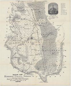
- Subject:
- Topical Subject: Mines and mineral resources, Topical Subject: IGS Annual Reports, Geographic Subject: Harrison County (Ind.), Topical Subject: Corydon Capit...
- Creator:
- Collett, John, 1828-1899
- Publisher:
- Indiana. Geological Survey
- Date Created:
- 1879
- Identifier:
- VAC3073-M-01554
- Genre:
- Geological maps
- Geographic Location:
- Coordinates: W0861951 W0855359 N0382520 N0375731
- Related URL:
- Catalog URL: https://iucat.iu.edu/catalog/18363798
- Abstract:
- Prepared for the 10th annual report of Prof. E.T. Cox, State Geologist by John Collett, 1878. Relief shown by hachures. Shows cities and towns, railroads, sp...
- Call Number:
- G4093.H4C5 1878 .C6
- Caption:
- Imprint: [Indianapolis] : [Geological Survey of Indiana], [1879] and Imprint: [Indianapolis] : [Indianapolis Journal Company, State printers], [1879]
- Physical Description:
- Dimensions: on sheet 44 x 36 cm and Scale: Approximately 1:130,000
- Alternate Identifier:
- Alternate ID: 390723IP and Title Control Number: a18363798
- Persistent URL:
- https://purl.dlib.indiana.edu/iudl/images/VAC3073/VAC3073-M-01554
- Provenance:
- 8th, 9th, and 10th Annual Reports (1876, 1877, 1878) / Indiana. Geological Survey.
-
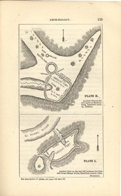
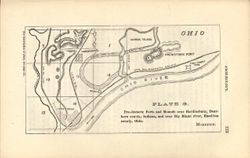
- Subject:
- Topical Subject: IGS Annual Reports, Topical Subject: Mounds, Topical Subject: Fortification, Prehistoric, Topical Subject: Indians of North America, Geograp...
- Creator:
- Morrison, Samuel (Civil engineer)
- Publisher:
- Indiana. Geological Survey
- Date Created:
- 1879
- Identifier:
- VAC3073-M-01548
- Genre:
- Pictorial maps
- Geographic Location:
- Coordinates: W0850758 W0844909 N0391829 N0385607
- Related URL:
- Catalog URL: https://iucat.iu.edu/catalog/18387663
- Abstract:
- At head of first title: Plate H , At head of second title: Plate I. Relief shown by hachures and spot heights. Shows prehistoric forts [Miami Fort and Oberti...
- Call Number:
- QE109 .A2
- Caption:
- Imprint: [Indianapolis] : [Geological Survey of Indiana], [1879] and Imprint: [Indianapolis] : [Indianapolis Journal Company, State printers], [1879]
- Physical Description:
- Dimensions: 22 x 14 cm and Scale: Scale not given.
- Alternate Identifier:
- Title Control Number: a18387663 and Alternate ID: 390723IP
- Persistent URL:
- https://purl.dlib.indiana.edu/iudl/images/VAC3073/VAC3073-M-01548
- Provenance:
- 8th, 9th, and 10th Annual Reports (1876, 1877, 1878) / Indiana. Geological Survey.
-
- Subject:
- Geographic Subject: New Garden (Ind. : Township), Topical Subject: Mounds, Topical Subject: Fortification, Prehistoric, Geographic Subject: Hamilton County (...
- Creator:
- Morrison, Samuel (Civil engineer)
- Publisher:
- Indiana. Geological Survey
- Date Created:
- 1879
- Identifier:
- VAC3073-M-01547
- Genre:
- Maps
- Geographic Location:
- Coordinates: W0845228 W0844558 N0390800 N0390448
- Related URL:
- Catalog URL: https://iucat.iu.edu/catalog/18387640
- Abstract:
- At head of title: Plate G. Relief shown by hachures. Shows prehistoric forts, mounds, waterways, and railroads. "The following map and diagrams are redu...
- Call Number:
- G4071.E15 1878 .M67
- Caption:
- Imprint: [Indianapolis] : [Indianapolis Journal Company, State printers], [1879] and Imprint: [Indianapolis] : [Geological Survey of Indiana], [1879]
- Physical Description:
- Scale: Scale approximately 1:55,000 and Dimensions: on sheet 14 x 21 cm
- Alternate Identifier:
- Title Control Number: a18387640 and Alternate ID: 390723IP
- Persistent URL:
- https://purl.dlib.indiana.edu/iudl/images/VAC3073/VAC3073-M-01547
- Provenance:
- 8th, 9th, and 10th Annual Reports (1876, 1877, 1878) / Indiana. Geological Survey.
-
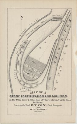
- Subject:
- Geographic Subject: Ohio River, Topical Subject: IGS Annual Reports, Topical Subject: Rivers, Topical Subject: Mounds, Topical Subject: Fortification, Geogra...
- Creator:
- Cox, E. T. (Edward Travers), 1821-1907 and Borden, W. W. (William Wesley), 1823-1906
- Publisher:
- Indiana. Geological Survey
- Date Created:
- 1873
- Identifier:
- VAC3073-M-01542
- Genre:
- Pictorial maps
- Geographic Location:
- Coordinates: W0853723 W0853635 N0382605 N0382513
- Related URL:
- Catalog URL: https://iucat.iu.edu/catalog/18318556
- Abstract:
- Surveyed by Prof. E. T. Cox and W. W. Borden. Pictorial map showing natural and artificial stone walls surrounding fields, timber, and mounds between the Ohi...
- Call Number:
- G4093.C4R4 1873 .C69
- Caption:
- Imprint: Indianapolis : Braden & Burford, Steam Lith., [1873] and Imprint: [Indianapolis] : [Geological Survey of Indiana], [1874]
- Physical Description:
- Dimensions: on sheet 22 x 14 cm and Scale: Scale not given.
- Alternate Identifier:
- Title Control Number: a18318556 and Alternate ID: 390723IP
- Persistent URL:
- https://purl.dlib.indiana.edu/iudl/images/VAC3073/VAC3073-M-01542
- Provenance:
- 5th Annual Report (1873) / Indiana. Geological Survey.
-
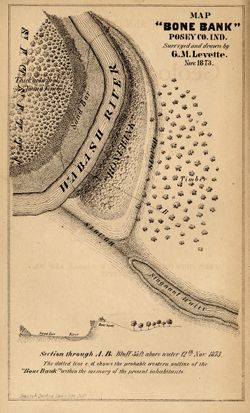
- Subject:
- Geographic Subject: Bone Bank Site (Ind.), Topical Subject: IGS Annual Reports, Geographic Subject: Posey County (Ind.), Topical Subject: Mississippian cultu...
- Creator:
- Levette, G. M. (Gilbert M.)
- Publisher:
- Indiana. Geological Survey
- Date Created:
- 1874
- Identifier:
- VAC3073-M-01540
- Genre:
- Pictorial maps and Geological cross-sections
- Geographic Location:
- Coordinates: W0880126 W0880126 N0374955 N0374955
- Related URL:
- Catalog URL: https://iucat.iu.edu/catalog/18308000
- Abstract:
- 1 map and 1 section on 1 sheet. Surveyed and drawn by G.M. Levette Nov. 1873. Shows the "probable western outline of the 'Bone Bank' within the ...
- Call Number:
- G4093.P6E15 1873 .L48
- Caption:
- Imprint: Inds. : Braden & Burford Steam Lith. [1874] and Imprint: [Indianapolis] : [Geological Survey of Indiana], [1874]
- Physical Description:
- Scale: Not drawn to scale. and Dimensions: on sheet 20 x 12 cm
- Alternate Identifier:
- Alternate ID: 390723IP and Title Control Number: a18308000
- Persistent URL:
- https://purl.dlib.indiana.edu/iudl/images/VAC3073/VAC3073-M-01540
- Provenance:
- 5th Annual Report (1873) / Indiana. Geological Survey.
-
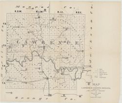
- Subject:
- Topical Subject: Mines and mineral resources, Topical Subject: Caves, Geographic Subject: Lawrence County (Ind.), Topical Subject: Geology, and Topical Subje...
- Creator:
- Collett, John, 1828-1899 and Cox, E. T. (Edward Travers), 1821-1907
- Publisher:
- Indiana. Geological Survey
- Date Created:
- 1874
- Identifier:
- VAC3073-M-01544
- Genre:
- Thematic maps
- Geographic Location:
- Coordinates: W0864107 W0861630 N0385938 N0384112
- Related URL:
- Catalog URL: https://iucat.iu.edu/catalog/18318621
- Abstract:
- Prepared for the 5th Annual Report of Prof. E.T. Cox. 1873. Geology by John Collett. Relief shown by hachures. Shows cities and towns, railroads, mills, cave...
- Call Number:
- G4093.L5C5 1873 .C6
- Caption:
- Imprint: [Indianapolis] : [Sentinel Co., printers], [1874] and Imprint: [Indianapolis] : [Geological Survey of Indiana], [1874]
- Physical Description:
- Scale: Approximately 1:120,000 and Dimensions: on sheet 37 x 44 cm
- Alternate Identifier:
- Title Control Number: a18318621 and Alternate ID: 390723IP
- Persistent URL:
- https://purl.dlib.indiana.edu/iudl/images/VAC3073/VAC3073-M-01544
- Provenance:
- 5th Annual Report (1873) / Indiana. Geological Survey.
-
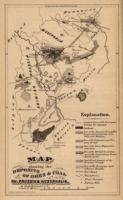
- Subject:
- Geographic Subject: North Rhine-Westphalia (Germany), Topical Subject: IGS Annual Reports, and Topical Subject: Mines and mineral resources
- Creator:
- Hartmann, Hugh
- Publisher:
- Indiana. Geological Survey
- Date Created:
- 1873
- Identifier:
- VAC3073-M-01541
- Genre:
- Geological maps
- Geographic Location:
- Coordinates: E0053400 E0095500 N0522700 N0485600
- Related URL:
- Catalog URL: https://iucat.iu.edu/catalog/18422455
- Abstract:
- Other title: Map showing the deposits of ores and coal in Rhineland Prussia and Westphalia. Shows coal beds and ore deposits by period as well as railroads, ...
- Call Number:
- G6361.H1 1873 .H3
- Caption:
- Imprint: [Indianapolis] [Geological Survey of Indiana], [1873]
- Physical Description:
- Scale: Approximately 1:3,352,800 and Dimensions: 18 x 11 cm
- Alternate Identifier:
- Alternate ID: 390723IP and Title Control Number: a18422455
- Persistent URL:
- https://purl.dlib.indiana.edu/iudl/images/VAC3073/VAC3073-M-01541
- Provenance:
- 5th Annual Report (1873) / Indiana. Geological Survey.
-
- Subject:
- Geographic Subject: Owen County (Ind.), Topical Subject: IGS Annual Reports, Topical Subject: Geology, Topical Subject: Mines and mineral resources, and Topi...
- Creator:
- Collett, John, 1828-1899
- Publisher:
- Indiana. Geological Survey
- Date Created:
- 1876
- Identifier:
- VAC3073-M-01176
- Genre:
- Geological maps
- Geographic Location:
- Coordinates: W0870316 W0863751 N0392824 N0390957
- Related URL:
- Catalog URL: https://iucat.iu.edu/catalog/18349290
- Abstract:
- Compiled for the 7th annual report of E.T. Cox, State Geologist , geology by Prof. John Collett, 1875. Relief shown by hachures. Shows cities and towns, rail...
- Call Number:
- G4093.O8C5 1875 .C6
- Caption:
- Imprint: [Indianapolis] : [Geological Survey of Indiana], [1876] and Imprint: [Indianapolis] : [Sentinel Co., printers], [1876]
- Physical Description:
- Scale: Approximately 1:130,000 and Dimensions: on sheet 40 x 45 cm
- Alternate Identifier:
- Title Control Number: a18349290 and Alternate ID: 390723IP
- Persistent URL:
- https://purl.dlib.indiana.edu/iudl/images/VAC3073/VAC3073-M-01176
- Provenance:
- 7th Annual Report (1875) / Indiana. Geological Survey.
-
- Subject:
- Topical Subject: Landowners, Geographic Subject: Scott County (Ind.), Topical Subject: IGS Annual Reports, and Topical Subject: Real property
- Creator:
- Borden, W. W. (William Wesley), 1823-1906
- Publisher:
- Indiana. Geological Survey
- Date Created:
- 1875
- Identifier:
- VAC3073-M-01147
- Genre:
- Cadastral maps
- Geographic Location:
- Coordinates: W0855524 W0853733 N0385016 N0383454
- Related URL:
- Catalog URL: https://iucat.iu.edu/catalog/18318693
- Abstract:
- Prepared for the sixth annual report of E.T. Cox, State Geologist / geology by W.W. Borden, 1874. Relief shown by hachures. Shows cities and towns, railroads...
- Call Number:
- G4093.S3G46 1874 .B6
- Caption:
- Imprint: [Indianapolis] : [Geological Survey of Indiana], [1875] and Imprint: [Indianapolis, Indiana] : [Sentinel Co., printers], [1875]
- Physical Description:
- Scale: Approximately 1:130,000 and Dimensions: 31 x 30 cm, on sheet 38 x 35 cm
- Alternate Identifier:
- Alternate ID: 390723IP and Title Control Number: a18318693
- Persistent URL:
- https://purl.dlib.indiana.edu/iudl/images/VAC3073/VAC3073-M-01147
- Provenance:
- 6th Annual Report (1874) / Indiana. Geological Survey.
-
- Subject:
- Geographic Subject: Indiana
- Publisher:
- Indiana. Geological Survey
- Date Created:
- 1966
- Identifier:
- VAC3073-M-01247
- Genre:
- Geological maps
- Related URL:
- Catalog URL: https://iucat.iu.edu/catalog/2789347
- Abstract:
- Each sheet includes "Columnar section," "Cross section," "Explanation," "Schematic section," sectionalized township d...
- Call Number:
- G4091.C5 s250 .I5 Danville 1966 Copy 2
- Physical Description:
- Scale: 1:250,000 and Dimensions: col. maps 66 x 102 cm.
- Persistent URL:
- https://purl.dlib.indiana.edu/iudl/images/VAC3073/VAC3073-M-01247
-
- Subject:
- Geographic Subject: Indiana, Geographic Subject: Illinois, Topical Subject: Geology, Stratigraphic, and Topical Subject: Geology
- Creator:
- Indiana. Geological Survey, Bleuer, N. K. (Ned Kermit), 1943-, Lineback, Jerry A. (Jerry Alvin), Hill, John R,, Gray, Henry Hamilton, 1922-, and Illinois Sta...
- Publisher:
- Indiana. Geological Survey
- Date Created:
- 1979
- Identifier:
- VAC3073-M-01251
- Genre:
- Quadrangle maps, Geological maps, and Geological cross-sections
- Geographic Location:
- Coordinates: W0880000 W0860000 N0400000 N0390000
- Related URL:
- Catalog URL: https://iucat.iu.edu/catalog/18437113
- Abstract:
- Indianapolis sheet. 1979 edition. Transverse Mercator projection. Geology compiled by H. H. Gray (Indiana) and J. A. Lineback (Illinois) from published and o...
- Call Number:
- G4091.C5 s250 .I5 Indianapolis 1979
- Caption:
- Imprint: [Bloomington] : Indiana Geological Survey, 1979
- Physical Description:
- Scale: 1:250,000. Vertical scale approximately 1:3,800 and Dimensions: 66 x 102 cm
- Alternate Identifier:
- Title Control Number: a18437113
- Persistent URL:
- https://purl.dlib.indiana.edu/iudl/images/VAC3073/VAC3073-M-01251
- Provenance:
- Indiana. Geological Survey. Regional geologic map , no. 1.
-
- Subject:
- Topical Subject: Oil fields, Geographic Subject: Indiana, and Topical Subject: Gas fields
- Creator:
- Cazee, J. T. (James T.)
- Publisher:
- Indiana. Geological Survey
- Date Created:
- 1998
- Identifier:
- VAC3073-M-00237
- Genre:
- Geological maps
- Geographic Location:
- W0880000 W0860000 N0395000 N0380000 and Coordinates: W0880700 W0844500 N0414500 N0375200
- Related URL:
- Catalog URL: https://iucat.iu.edu/catalog/4995550
- Abstract:
- "Compilation complete to December 1998." "Base map digitized from 1978 U.S. Geological Survey map of Indiana. Scale 1:500,000."
- Call Number:
- G4091.H8 1998 .C3
- Caption:
- Imprint: Bloomington : Indiana Geological Survey, 1998.
- Physical Description:
- Scale: 1:550,000, 1:1:275,000, and Dimensions: 83 x 150 cm
- Alternate Identifier:
- Title Control Number: a4995550
- Persistent URL:
- https://purl.dlib.indiana.edu/iudl/images/VAC3073/VAC3073-M-00237
-
- Subject:
- Geographic Subject: Illinois, Topical Subject: Geology, Geographic Subject: Indiana, and Topical Subject: Geology, Stratigraphic
- Creator:
- Keller, Stanley J., Indiana. Geological Survey, Illinois State Geological Survey, Johnson, Gerald H., Wayne, William J. (William John), 1922-, and Atherton, ...
- Publisher:
- Indiana. Geological Survey
- Date Created:
- 1962
- Identifier:
- VAC3073-M-01248
- Genre:
- Geological maps, Quadrangle maps, and Geological cross-sections
- Geographic Location:
- Coordinates: W0880000 W0860000 N0410000 N0400000
- Related URL:
- Catalog URL: https://iucat.iu.edu/catalog/16799905
- Abstract:
- By William J. Wayne, Gerald H. Johnson, and Stanley J. Keller. Indiana Geological Survey in cooperation with Illinois State Geological Survey. Base modified ...
- Call Number:
- G4091.C5 s250 .I5 Danville 1962
- Caption:
- Imprint: [Indianapolis] : Indiana Geological Survey, 1966
- Physical Description:
- Scale: 1:250,000 and Dimensions: 76 x 105 cm
- Alternate Identifier:
- Title Control Number: a16799905
- Persistent URL:
- https://purl.dlib.indiana.edu/iudl/images/VAC3073/VAC3073-M-01248
- Provenance:
- Indiana. Geological Survey. Regional geologic map , no. 2.
-
- Subject:
- Topical Subject: IGS Annual Reports, Topical Subject: Geology, Economic, Geographic Subject: Daviess County (Ind.), Geographic Subject: Martin County (Ind.),...
- Creator:
- Collett, John, 1828-1899, Levette, G. M. (Gilbert M.), and Cox, E. T. (Edward Travers), 1821-1907
- Publisher:
- Indiana. Geological Survey
- Date Created:
- 1871
- Identifier:
- VAC3073-M-01263
- Genre:
- Geological maps
- Geographic Location:
- Coordinates: W0871645 W0863823 N0385617 N0382924
- Related URL:
- Catalog URL: https://iucat.iu.edu/catalog/18282530
- Abstract:
- Drawn by G.M. Levette for the second annual report of Prof. E.T. Cox, state geologist , [geology by John Collett]. Shows worked coal, coal outcrops, iron ore...
- Call Number:
- G4093.D2H1 1870 .L4
- Caption:
- Imprint: Indianapolis, Ind. : Geological Survey of Indiana, [1871]
- Physical Description:
- Scale: Approximately 1:85,000 and Dimensions: on sheet 63 x 79 cm
- Alternate Identifier:
- Alternate ID: 390721IP and Title Control Number: a18282530
- Persistent URL:
- https://purl.dlib.indiana.edu/iudl/images/VAC3073/VAC3073-M-01263
- Provenance:
- 2nd Annual Report (1870) / Indiana. Geological Survey.
-
- Subject:
- Topical Subject: Petroleum pipelines, Geographic Subject: Indiana, Topical Subject: Petroleum refineries, Topical Subject: Natural gas pipelines, and Geograp...
- Creator:
- Keller, Stanley J.
- Publisher:
- Indiana. Geological Survey
- Date Created:
- 1972
- Identifier:
- VAC3073-M-00426
- Genre:
- Thematic maps
- Geographic Location:
- Coordinates: W0880700 W0844700 N0414500 N0374600
- Related URL:
- Catalog URL: https://iucat.iu.edu/catalog/5304663
- Abstract:
- "Compilation complete to July 1, 1972." "Base by U.S. Geological Survey, 1950." "Miscellaneous map no. 18."
- Call Number:
- G4091 .H8 1972 .K4
- Caption:
- Imprint: [Bloomington, IN]: Indiana Geological Survey, 1973
- Physical Description:
- Dimensions: 91 x 59 cm and 89 x 41 cm, on sheet 101 x 76 cm and Scale: 1:500,000
- Alternate Identifier:
- Title Control Number: a5304663
- Persistent URL:
- https://purl.dlib.indiana.edu/iudl/images/VAC3073/VAC3073-M-00426
-
- Subject:
- Topical Subject: Caves, Topical Subject: IGS Annual Reports, Topical Subject: Speleothems, and Geographic Subject: Wyandotte Cave (Ind.)
- Creator:
- Collett, John, 1828-1899
- Publisher:
- Indiana. Geological Survey
- Date Created:
- 1879
- Identifier:
- VAC3073-M-01552
- Genre:
- Drawings, Pictorial works, Tables (Data), and Thematic maps
- Geographic Location:
- Coordinates: W0861746 W0861746 N0381341 N0381341
- Related URL:
- Catalog URL: https://iucat.iu.edu/catalog/18372653
- Abstract:
- Prepared for the 10th Annual Report of Prof. E. T. Cox, State Geologist, by John Collett, A. M. Relief shown by hachures. Includes sketches of some cave feat...
- Call Number:
- G4093.C7C23 1878 .C6
- Caption:
- Imprint: [Indianapolis] : [Indianapolis Journal Company, State printers], [1879] and Imprint: [Indianapolis] : [Geological Survey of Indiana], [1879]
- Physical Description:
- Dimensions: on sheet 54 x 46 cm and Scale: Approximately 1:11,000
- Alternate Identifier:
- Alternate ID: 390723IP and Title Control Number: a18372653
- Persistent URL:
- https://purl.dlib.indiana.edu/iudl/images/VAC3073/VAC3073-M-01552
- Provenance:
- 8th, 9th, and 10th Annual Reports (1876, 1877, 1878) / Indiana. Geological Survey.
-
- Subject:
- Geographic Subject: New Garden (Ind. : Township), Topical Subject: Earthworks (Archaeology), and Topical Subject: IGS Annual Reports
- Creator:
- Macpherson, J. C. (John C.)
- Publisher:
- Indiana. Geological Survey
- Date Created:
- 1879
- Identifier:
- VAC3073-M-01550
- Genre:
- Pictorial maps
- Geographic Location:
- Coordinates: W0845400 W0845300 N0395800 N0395700
- Related URL:
- Catalog URL: https://iucat.iu.edu/catalog/18387636
- Abstract:
- At head of title: Plate C. Shows streams, pits, and earthwork [Indiana Adena Square?] with measurements. Detached from: Eighth, ninth, and tenth annual re...
- Call Number:
- G4094.N438 1978 .M33
- Caption:
- Imprint: [Indianapolis] : [Indianapolis Journal Company, State printers], [1879] and Imprint: [Indianapolis] : [Geological Survey of Indiana], [1879]
- Physical Description:
- Dimensions: on sheet 14 x 21 cm and Scale: Approximately 1:6,000. 1 inch = 500 ft.
- Alternate Identifier:
- Alternate ID: 390723IP and Title Control Number: a18387636
- Persistent URL:
- https://purl.dlib.indiana.edu/iudl/images/VAC3073/VAC3073-M-01550
- Provenance:
- 8th, 9th, and 10th Annual Reports (1876, 1877, 1878) / Indiana. Geological Survey.
-
- Subject:
- Topical Subject: Geology, Economic, Geographic Subject: Martin County (Ind.), Geographic Subject: Daviess County (Ind.), Topical Subject: IGS Annual Reports,...
- Creator:
- Collett, John, 1828-1899, Cox, E. T. (Edward Travers), 1821-1907, and Levette, G. M. (Gilbert M.)
- Publisher:
- Indiana. Geological Survey
- Date Created:
- 1871
- Identifier:
- VAC3073-M-01531
- Genre:
- Geological maps
- Geographic Location:
- Coordinates: W0871645 W0863823 N0385617 N0382924
- Related URL:
- Catalog URL: https://iucat.iu.edu/catalog/18282530
- Abstract:
- Drawn by G.M. Levette for the second annual report of Prof. E.T. Cox, state geologist , [geology by John Collett]. Shows worked coal, coal outcrops, iron ore...
- Call Number:
- G4093.D2H1 1870 .L4
- Caption:
- Imprint: Indianapolis, Ind. : Geological Survey of Indiana, [1871]
- Physical Description:
- Scale: Approximately 1:85,000 and Dimensions: on sheet 63 x 79 cm
- Alternate Identifier:
- Title Control Number: a18282530 and Alternate ID: 390721IP
- Persistent URL:
- https://purl.dlib.indiana.edu/iudl/images/VAC3073/VAC3073-M-01531
- Provenance:
- 2nd Annual Report (1870) / Indiana. Geological Survey.
-
- Subject:
- Topical Subject: Geology, Economic, Geographic Subject: Sullivan County (Ind.), Topical Subject: Mines and mineral resources, and Topical Subject: IGS Annual...
- Creator:
- Collett, John, 1828-1899, Levette, G. M. (Gilbert M.), and Cox, E. T. (Edward Travers), 1821-1907
- Publisher:
- Indiana. Geological Survey
- Date Created:
- 1871
- Identifier:
- VAC3073-M-01533
- Genre:
- Geological maps
- Geographic Location:
- Coordinates: W0873941 W0870603 N0392100 N0384802
- Related URL:
- Catalog URL: https://iucat.iu.edu/catalog/18283359
- Abstract:
- Drawn by G.M. Levette, for the second annual report of Prof. E.T. Cox, state geologist , geology by John Collett. "Braden & Burford, Lith., Indianap...
- Call Number:
- QE109 .A2 1870 map Sullivan
- Caption:
- Imprint: Indianapolis, Ind. : Geological Survey of Indiana, [1871]
- Physical Description:
- Scale: Approximately 1:85,000 and Dimensions: on sheet 82 x 64 cm
- Alternate Identifier:
- Alternate ID: 390721IP and Title Control Number: a18283359
- Persistent URL:
- https://purl.dlib.indiana.edu/iudl/images/VAC3073/VAC3073-M-01533
- Provenance:
- 2nd Annual Report (1870) / Indiana. Geological Survey.
-
- Subject:
- Topical Subject: Coal mines and mining and Geographic Subject: Indiana
- Creator:
- Hutchison, Harold C. (Harold Christy), 1925-
- Publisher:
- Indiana. Geological Survey
- Date Created:
- 1970
- Identifier:
- VAC3073-M-00965
- Genre:
- Mine maps
- Geographic Location:
- Coordinates: W0880150 W0862422 N0403746 N0374559
- Related URL:
- Catalog URL: https://iucat.iu.edu/catalog/5046399
- Abstract:
- Blue line print. "Base modified from Indiana Department of Conservation, Geological Survey. Base map of portion of western Indiana, 1951." Includ...
- Call Number:
- G4091 .H9 1970 .H8
- Caption:
- Imprint: [Bloomington, Ind.] : Indiana Dept. of Conservation, Geological Survey, [1970]
- Physical Description:
- Dimensions: 88 x 54 cm and Scale: 1:325,000
- Alternate Identifier:
- Title Control Number: a5046399
- Persistent URL:
- https://purl.dlib.indiana.edu/iudl/images/VAC3073/VAC3073-M-00965
-

- Subject:
- Topical Subject: Geology, Stratigraphic, Topical Subject: Geology, Geographic Subject: Indiana, and Geographic Subject: Illinois
- Creator:
- Gray, Henry Hamilton, 1922-
- Publisher:
- Indiana. Geological Survey
- Date Created:
- 1910
- Identifier:
- VAC3073-M-01254
- Genre:
- Geological cross-sections, Quadrangle maps, and Geological maps
- Geographic Location:
- Coordinates: W0880000 W0860000 N0390000 N0380000
- Related URL:
- Catalog URL: https://iucat.iu.edu/catalog/18455600
- Abstract:
- By Henry H. Gray, William J. Wayne, and Charles E. Wier , Indiana Geological Survey, in cooperation with Illinois State Geological Survey. Transverse Mercato...
- Call Number:
- G4091.C5 s250 .I5 Vincennes
- Caption:
- Imprint: [Bloomington, Ind.] : The Survey, 1970
- Physical Description:
- Dimensions: 76 x 102 cm and Scale: 1:250,000. Vertical scale approximately 1:11,500
- Alternate Identifier:
- Title Control Number: a18455600
- Persistent URL:
- https://purl.dlib.indiana.edu/iudl/images/VAC3073/VAC3073-M-01254
- Provenance:
- Indiana. Geological Survey. Regional geologic map , no. 3.
-
- Subject:
- Topical Subject: Coal mines and mining and Geographic Subject: Indiana
- Creator:
- Weber, Licia
- Publisher:
- Indiana. Geological Survey
- Date Created:
- 1986
- Identifier:
- VAC3073-M-00850
- Genre:
- Mine maps
- Geographic Location:
- Coordinates: W0880500 W0861800 N0404200 N0374600
- Related URL:
- Catalog URL: https://iucat.iu.edu/catalog/4438471
- Abstract:
- Blue line print. Includes location map.
- Call Number:
- G4091.H9 1986 .W4
- Caption:
- Imprint: [Bloomington, IN]: Indiana, Geological Survey, [1986]
- Physical Description:
- Dimensions: 93 x 44 cm and Scale: 1:350,000
- Alternate Identifier:
- Title Control Number: a4438471
- Persistent URL:
- https://purl.dlib.indiana.edu/iudl/images/VAC3073/VAC3073-M-00850
-
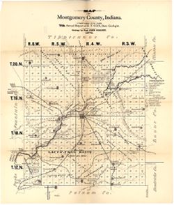
- Subject:
- Topical Subject: Mines and mineral resources, Geographic Subject: Montgomery County (Ind.), Topical Subject: Coal mines and mining, Topical Subject: IGS Annu...
- Creator:
- Collett, John, 1828-1899 and Cox, E. T. (Edward Travers), 1821-1907
- Publisher:
- Indiana. Geological Survey
- Date Created:
- 1876
- Identifier:
- VAC3073-M-01175
- Genre:
- Geological maps
- Geographic Location:
- Coordinates: W0870530 W0864134 N0401301 N0395151
- Related URL:
- Catalog URL: https://iucat.iu.edu/catalog/18349279
- Abstract:
- Compiled for the 7th annual report of E.T. Cox, State Geologist , geology by Prof. John Collett, 1875. Relief shown by hachures. Shows cities and towns, rail...
- Call Number:
- G4093.M8C5 1875 .C6
- Caption:
- Imprint: [Indianapolis] : [Geological Survey of Indiana], [1876] and Imprint: [Indianapolis] : [Sentinel Company, printers], [1876]
- Physical Description:
- Scale: Approximately 1:120,000 and Dimensions: on sheet 48 x 40 cm
- Alternate Identifier:
- Alternate ID: 390723IP and Title Control Number: a18349279
- Persistent URL:
- https://purl.dlib.indiana.edu/iudl/images/VAC3073/VAC3073-M-01175
- Provenance:
- 7th Annual Report (1875) / Indiana. Geological Survey.
-
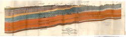
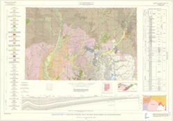
![[Coal measure sections in Indiana, Southern Illinois, and Western Kentucky]](https://iiif.uits.iu.edu/iiif/2/bz60f023f%2Ffiles%2F64b4d7e0-2da2-4574-93ae-d19cd0523815/full/250,/0/default.jpg)
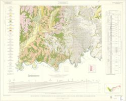
- Subject:
- Geographic Subject: Indiana, Topical Subject: Geology, Stratigraphic, Geographic Subject: Illinois, Geographic Subject: Kentucky, Topical Subject: Coal, and ...
- Creator:
- Lesquereux, Leo, 1806-1889 and Cox, E. T. (Edward Travers), 1821-1907
- Publisher:
- Indiana. Geological Survey
- Date Created:
- 1871
- Identifier:
- VAC3073-M-01181
- Genre:
- Tables (Data) and Charts
- Related URL:
- Catalog URL: https://iucat.iu.edu/catalog/18308391
- Abstract:
- By Prof. E. T. Cox, Prof Leo Lesquereux. Title derived from caption titles. Includes 3 sections showing coal measures. No. 3. Connected section of coal measu...
- Call Number:
- G4091.H9 1870 .C69
- Caption:
- Imprint: [Indianapolis] : [Geological Survey of Indiana], [1871]
- Physical Description:
- Dimensions: 21 x 23 cm and Scale: Scale not given.
- Alternate Identifier:
- Title Control Number: a18308391 and Alternate ID: 390721IP
- Persistent URL:
- https://purl.dlib.indiana.edu/iudl/images/VAC3073/VAC3073-M-01181
- Provenance:
- 2nd Annual Report (1870) / Indiana. Geological Survey.
-
- Subject:
- Topical Subject: Geology and Geographic Subject: Indiana
- Creator:
- Patton, John B. (John Barratt), 1915-
- Publisher:
- Indiana. Geological Survey
- Date Created:
- 1956
- Identifier:
- VAC3073-M-00212
- Genre:
- Geological maps
- Geographic Location:
- Coordinates: W0880000 W0844500 N0414500 N0375200
- Related URL:
- Catalog URL: https://iucat.iu.edu/catalog/5888483
- Abstract:
- "Base from Map of Indiana, 1950 edition, published by the U.S. Geological Survey. Minor revisions and additions made from Indiana Department of Conserva...
- Call Number:
- G4091 .C5 1956 .P3
- Caption:
- Imprint: [Bloomington] : Indiana Geological Survey, 1956.
- Physical Description:
- Dimensions: 59 x 31 cm and Scale: 1:1,000,000
- Alternate Identifier:
- Title Control Number: a5888483
- Persistent URL:
- https://purl.dlib.indiana.edu/iudl/images/VAC3073/VAC3073-M-00212
-
- Subject:
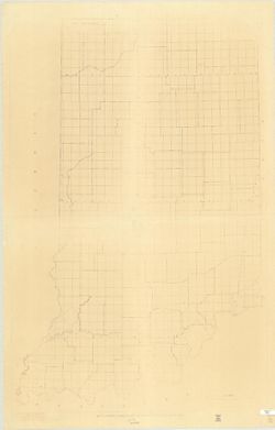
- Topical Subject: Coal mines and mining, Geographic Subject: Vigo County (Ind.), Topical Subject: Geology, and Topical Subject: IGS Annual Reports
- Creator:
- Cox, E. T. (Edward Travers), 1821-1907
- Publisher:
- Indiana. Geological Survey
- Date Created:
- 1876
- Identifier:
- VAC3073-M-01174
- Genre:
- Geological maps
- Geographic Location:
- Coordinates: W0873635 W0871156 N0393634 N0391532
- Related URL:
- Catalog URL: https://iucat.iu.edu/catalog/18349323
- Abstract:
- Compiled for the seventh annual report of E.T. Cox, State Geologist , geology by Prof. E.T. Cox, 1875. Shows cities and towns, railroads, coal seams and outc...
- Call Number:
- G4093.V5C5 1875 .C6
- Caption:
- Imprint: [Indianapolis] : [Sentinel Company, printers], [1876] and Imprint: [Indianapolis] : [Geological Survey of Indiana], [1876]
- Physical Description:
- Scale: Approximately 1:120,000 and Dimensions: on sheet 39 x 45 cm
- Alternate Identifier:
- Title Control Number: a18349323 and Alternate ID: 390723IP
- Persistent URL:
- https://purl.dlib.indiana.edu/iudl/images/VAC3073/VAC3073-M-01174
- Provenance:
- 7th Annual Report (1875) / Indiana. Geological Survey.
-
- Subject:
- Topical Subject: Administrative and political divisions and Geographic Subject: Indiana
- Creator:
- Moran, W. H. (William H.)
- Publisher:
- Indiana. Geological Survey
- Date Created:
- 1951
- Identifier:
- VAC3073-M-00001
- Genre:
- Maps
- Geographic Location:
- Coordinates: W0880500 W0844700 N0414500 N0374600
- Related URL:
- Catalog URL: https://iucat.iu.edu/catalog/1233513
- Abstract:
- Photocopy, 118 x 77 cm "November, 1951." "Traced from compilation proof sheets of new base map of Indiana, prepared by the U.S. Geological Sur...
- Call Number:
- G4091 .A1 1951 .M6
- Caption:
- Imprint: Bloomington, Ind.: Indiana Geological Survey, 1951.
- Physical Description:
- Scale: 1:380,160 and Dimensions: 118 x 77 cm
- Alternate Identifier:
- Title Control Number: AKM2483BB
- Persistent URL:
- https://purl.dlib.indiana.edu/iudl/images/VAC3073/VAC3073-M-00001
-
- Subject:
- Geographic Subject: Illinois, Topical Subject: Geology, Topical Subject: Geology, Stratigraphic, and Geographic Subject: Indiana
- Creator:
- Gray, Henry Hamilton, 1922-, Wier, Charles E. (Charles Eugene), 1921-, Indiana. Geological Survey, Wayne, William J. (William John), 1922-, and Illinois Stat...
- Publisher:
- Indiana. Geological Survey
- Date Created:
- 1970
- Identifier:
- VAC3073-M-01257
- Genre:
- Quadrangle maps, Geological maps, and Geological cross-sections
- Geographic Location:
- Coordinates: W0880000 W0860000 N0390000 N0380000
- Related URL:
- Catalog URL: https://iucat.iu.edu/catalog/18455600
- Abstract:
- By Henry H. Gray, William J. Wayne, and Charles E. Wier , Indiana Geological Survey, in cooperation with Illinois State Geological Survey. Transverse Mercato...
- Call Number:
- G4091.C5 s250 .I5 Vincennes 1970
- Physical Description:
- Dimensions: 76 x 102 cm and Scale: 1:250,000
- Alternate Identifier:
- Title Control Number: a18455600
- Persistent URL:
- https://purl.dlib.indiana.edu/iudl/images/VAC3073/VAC3073-M-01257
- Provenance:
- Indiana. Geological Survey. Regional geologic map , no. 3.
-
- Subject:
- Topical Subject: Geology, Economic, Topical Subject: Mines and mineral resources, Geographic Subject: Sullivan County (Ind.), and Topical Subject: IGS Annual...
- Creator:
- Levette, G. M. (Gilbert M.), Collett, John, 1828-1899, and Cox, E. T. (Edward Travers), 1821-1907
- Publisher:
- Indiana. Geological Survey
- Date Created:
- 1871
- Identifier:
- VAC3073-M-01242
- Genre:
- Geological maps
- Geographic Location:
- Coordinates: W0873941 W0870603 N0392100 N0384802
- Related URL:
- Catalog URL: https://iucat.iu.edu/catalog/18283359
- Abstract:
- Drawn by G.M. Levette, for the second annual report of Prof. E.T. Cox, state geologist , geology by John Collett. "Braden & Burford, Lith., Indianap...
- Call Number:
- G4093.S8H1 1870 .L4
- Caption:
- Imprint: Indianapolis, Ind. : Geological Survey of Indiana, [1871]
- Physical Description:
- Scale: Approximately 1:85,000 and Dimensions: on sheet 82 x 64 cm
- Alternate Identifier:
- Title Control Number: a18283359 and Alternate ID: 390721IP
- Persistent URL:
- https://purl.dlib.indiana.edu/iudl/images/VAC3073/VAC3073-M-01242
- Provenance:
- 2nd Annual Report (1870) / Indiana. Geological Survey.
-
- Subject:
- Geographic Subject: Indiana, Topical Subject: Coal, and Topical Subject: Mines and mineral resources
- Creator:
- Shaffer, Nelson R.
- Publisher:
- Indiana. Geological Survey
- Date Created:
- 1998
- Identifier:
- VAC3073-M-00836
- Genre:
- Geological maps
- Geographic Location:
- Coordinates: W0880700 W0844500 N0414500 N0375200
- Related URL:
- Catalog URL: https://iucat.iu.edu/catalog/4640205
- Abstract:
- Includes pie chart and list of further reading. "1984 (Modified 1997)."
- Call Number:
- G4091.H5 1997 .S5
- Caption:
- Imprint: [Bloomington, Ind.] : Indiana Geological Survey, 1998.
- Physical Description:
- Scale: 1:500,000 and Dimensions: 97 x 72 cm
- Alternate Identifier:
- Title Control Number: ALN0867BB
- Persistent URL:
- https://purl.dlib.indiana.edu/iudl/images/VAC3073/VAC3073-M-00836
-
- Subject:
- Topical Subject: Coal mines and mining and Geographic Subject: Indiana
- Creator:
- Wier, Charles E. (Charles Eugene), 1921-
- Publisher:
- Indiana. Geological Survey
- Date Created:
- 1952
- Identifier:
- VAC3073-M-00414
- Genre:
- Mine maps
- Geographic Location:
- Coordinates: W0873255 W0862521 N0403749 N0374618
- Related URL:
- Catalog URL: https://iucat.iu.edu/catalog/5326199
- Abstract:
- Shows southwest quadrant of Indiana. Includes location map and "Diagram of township showing arrangement of sections." "1952."
- Call Number:
- G4091.H9 1952 .W54
- Caption:
- Imprint: [Bloomington, Ind.?] : Indiana Dept. of Conservation, Geological Survey, [1952]
- Physical Description:
- Dimensions: 66 x 31 cm and Scale: 1:500,000
- Alternate Identifier:
- Title Control Number: a5326199
- Persistent URL:
- https://purl.dlib.indiana.edu/iudl/images/VAC3073/VAC3073-M-00414
-
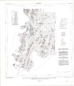
- Subject:
- Topical Subject: Coal, Topical Subject: Geology, Stratigraphic, Topical Subject: Geology, and Geographic Subject: Posey County (Ind.)
- Creator:
- Ault, Curtis H.
- Publisher:
- Indiana. Geological Survey
- Date Created:
- 1997
- Identifier:
- VAC3073-M-00334
- Genre:
- Mine maps
- Geographic Location:
- Coordinates: W0880600 W0874100 N0381400 N0374600
- Related URL:
- Catalog URL: https://iucat.iu.edu/catalog/4995833
- Abstract:
- Coordinates printed at top and lower margin are incorrect. Includes index map, text, and sectionized township diagram.
- Call Number:
- G4093.P6 H9 1997 .A9
- Caption:
- Imprint: [Bloomington, Ind.] : Indiana University, Indiana Geological Survey, 1997.
- Physical Description:
- Dimensions: 86 x 79 cm and Scale: 1:66,000
- Alternate Identifier:
- Title Control Number: a4995833
- Persistent URL:
- https://purl.dlib.indiana.edu/iudl/images/VAC3073/VAC3073-M-00334
-
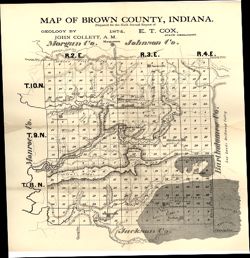
- Subject:
- Topical Subject: IGS Annual Reports, Geographic Subject: Brown County (Ind.), Topical Subject: Geology, and Topical Subject: Mines and mineral resources
- Creator:
- Collett, John, 1828-1899
- Publisher:
- Indiana. Geological Survey
- Date Created:
- 1875
- Identifier:
- VAC3073-M-01148
- Genre:
- Geological maps
- Geographic Location:
- Coordinates: W0862253 W0860449 N0392042 N0390248
- Related URL:
- Catalog URL: https://iucat.iu.edu/catalog/18318678
- Abstract:
- Prepared for the sixth annual report of E.T. Cox, State Geologist , geology by John Collett, 1874. Relief shown by hachures. Shows cities and towns, railroad...
- Call Number:
- G4093.B7C5 1874 .C6
- Caption:
- Imprint: [Indianapolis] : [Sentinel Company, printers], [1875] and Imprint: [Indianapolis] : [Geological Survey of Indiana], [1875]
- Physical Description:
- Scale: Approximately 1:120,000 and Dimensions: on sheet 39 x 35 cm
- Alternate Identifier:
- Alternate ID: 390723IP and Title Control Number: a18318678
- Persistent URL:
- https://purl.dlib.indiana.edu/iudl/images/VAC3073/VAC3073-M-01148
- Provenance:
- 6th Annual Report (1874) / Indiana. Geological Survey.
-
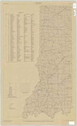
- Subject:
- Topical Subject: Coal mines and mining and Geographic Subject: Indiana
- Creator:
- Hutchison, Harold C. (Harold Christy), 1925-
- Publisher:
- Indiana. Geological Survey
- Date Created:
- 1975
- Identifier:
- VAC3073-M-00704
- Genre:
- Mine maps
- Geographic Location:
- Coordinates: W0872723 W0862628 N0403749 N0374618
- Related URL:
- Catalog URL: https://iucat.iu.edu/catalog/5050615
- Abstract:
- Blue line print. "Base modified from Indiana Department of Conservation, Geological Survey, Base map of portion of western Indiana, 1951." Includes...
- Call Number:
- G4091 .H9 1975 .H8
- Caption:
- Imprint: [Bloomington, Ind.] : Indiana Dept. of Conservation, Geological Survey, [1975]
- Physical Description:
- Scale: 1:325,000 and Dimensions: 88 x 54 cm
- Alternate Identifier:
- Title Control Number: a5050615
- Persistent URL:
- https://purl.dlib.indiana.edu/iudl/images/VAC3073/VAC3073-M-00704
-
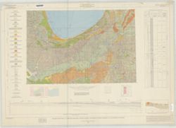
- Subject:
- Geographic Subject: Indiana, Northwest, Geographic Subject: Michigan, Geographic Subject: Indiana, Topical Subject: Geology, Geographic Subject: Illinois, To...
- Creator:
- Illinois State Geological Survey, Indiana. Geological Survey, Keller, Stanley J., and Schneider, Allan F. (Allan Frank), 1926-
- Publisher:
- Indiana. Geological Survey
- Date Created:
- 1970
- Identifier:
- VAC3073-M-01535
- Genre:
- Geological cross-sections, Quadrangle maps, and Geological maps
- Geographic Location:
- Coordinates: W0880000 W0860000 N0420000 N0410000
- Related URL:
- Catalog URL: https://iucat.iu.edu/catalog/17017966
- Abstract:
- By Allan F. Schneider and Stanley J. Keller. Transverse Mercator projection. "Indiana Geological Survey in cooperation with Illinois State Geological Su...
- Call Number:
- G4091.C5 1970 .G3
- Caption:
- Imprint: [Bloomington, Ind.] : Indiana Geological Survey, 1970
- Physical Description:
- Scale: 1:250,000 and Dimensions: 44 x 67 cm, on sheet 74 x 106 cm
- Alternate Identifier:
- Title Control Number: a17017966
- Persistent URL:
- https://purl.dlib.indiana.edu/iudl/images/VAC3073/VAC3073-M-01535
- Provenance:
- Indiana. Geological Survey. Regional geologic map , no. 4.
-
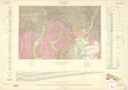
- Subject:
- Topical Subject: Geology, Stratigraphic, Geographic Subject: Illinois, Topical Subject: Geology, and Geographic Subject: Indiana
- Creator:
- Wier, Charles E. (Charles Eugene), 1921-
- Publisher:
- Indiana. Geological Survey
- Date Created:
- 1961
- Identifier:
- VAC3073-M-01250
- Genre:
- Quadrangle maps, Geological maps, and Geological cross-sections
- Geographic Location:
- Coordinates: W0880000 W0860000 N0400000 N0390000
- Related URL:
- Catalog URL: https://iucat.iu.edu/catalog/18422608
- Abstract:
- By Charles E. Wier and Henry H. Gray. Geology by H.H. Gray [and others]. Drafted by R. E. Judah and W. H. Moran. Base modified from Army Map Service map NJ 1...
- Call Number:
- G4091.C5 s250 .I5 Indianapolis 1961
- Caption:
- Imprint: [Indianapolis] : Indiana Geological Survey, 1961
- Physical Description:
- Scale: 1:250,000. Vertical scale approximately 1:1,200 and Dimensions: on sheet 74 x 105 cm
- Alternate Identifier:
- Title Control Number: a18422608
- Persistent URL:
- https://purl.dlib.indiana.edu/iudl/images/VAC3073/VAC3073-M-01250
- Provenance:
- Indiana. Geological Survey. Regional geologic map.
-
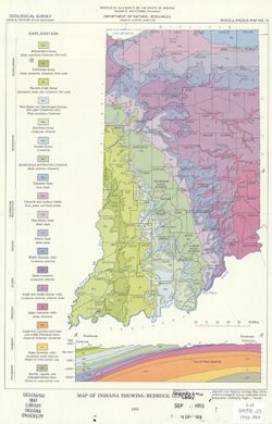
- Subject:
- Geographic Subject: Indiana and Topical Subject: Geology
- Creator:
- Purcell, Roger L.
- Publisher:
- Indiana. Geological Survey
- Date Created:
- 1970
- Identifier:
- VAC3073-M-00975
- Genre:
- Geological maps
- Geographic Location:
- Coordinates: W0880500 W0844700 N0414500 N0374600
- Related URL:
- Catalog URL: https://iucat.iu.edu/catalog/5363412
- Abstract:
- Includes geological cross-section.
- Call Number:
- G4091 .C5 1970 .P87
- Caption:
- Imprint: Indianapolis, Ind. : Indiana Geological Survey, 1970.
- Physical Description:
- Scale: 1:1,800,000 and Dimensions: 31 x 22 cm
- Alternate Identifier:
- Title Control Number: a5363412
- Persistent URL:
- https://purl.dlib.indiana.edu/iudl/images/VAC3073/VAC3073-M-00975
-
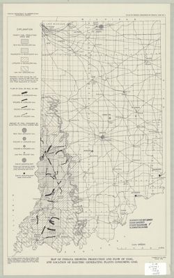
- Subject:
- Geographic Subject: Indiana, Topical Subject: Coal-fired power plants, Topical Subject: Coal, and Topical Subject: Coal mines and mining
- Creator:
- Wier, Charles E. (Charles Eugene), 1921-
- Publisher:
- Indiana. Geological Survey
- Date Created:
- 1953
- Identifier:
- VAC3073-M-00792
- Genre:
- Geological maps
- Geographic Location:
- Coordinates: W0880500 W0844700 N0414500 N0374600
- Related URL:
- Catalog URL: https://iucat.iu.edu/catalog/5325766
- Abstract:
- "1953."
- Call Number:
- G4091.H9 1953 .W54
- Caption:
- Imprint: [Bloomington, Ind.?] : Indiana Dept. of Conservation, Geological Survey, [1953]
- Physical Description:
- Dimensions: 66 x 31 cm and Scale: 1:1,000,000
- Alternate Identifier:
- Title Control Number: a5325766
- Persistent URL:
- https://purl.dlib.indiana.edu/iudl/images/VAC3073/VAC3073-M-00792
-
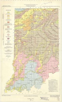
- Subject:
- Topical Subject: Glaciology, Topical Subject: Drift, Topical Subject: Glacial landforms, and Geographic Subject: Indiana
- Creator:
- Wayne, William J. (William John), 1922-
- Publisher:
- Indiana. Geological Survey
- Date Created:
- 1958
- Identifier:
- VAC3073-M-00573
- Genre:
- Geological maps and Thematic maps
- Geographic Location:
- Coordinates: W0880000 W0844500 N0414500 N0375200
- Related URL:
- Catalog URL: https://iucat.iu.edu/catalog/5888478
- Abstract:
- "Base modified from U. S. Geological Survey Base map of Indiana, 1953." "Reprinted with minor modifications, 1963."
- Call Number:
- G4091.C38 1958 .W3
- Caption:
- Imprint: Bloomington : Indiana Geological Survey, 1958.
- Physical Description:
- Scale: 1:1,000,000 and Dimensions: 46 x 30 cm
- Alternate Identifier:
- Title Control Number: a5888478
- Persistent URL:
- https://purl.dlib.indiana.edu/iudl/images/VAC3073/VAC3073-M-00573
-
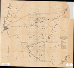
- Subject:
- Geographic Subject: Clay County (Ind.), Topical Subject: IGS Annual Reports, and Topical Subject: Coal
- Creator:
- Levette, G. M. (Gilbert M.)
- Publisher:
- Indiana. Geological Survey
- Date Created:
- 1869
- Identifier:
- VAC3073-M-00669
- Genre:
- Thematic maps
- Geographic Location:
- Coordinates: W0871400 W0865700 N0393700 N0391000
- Related URL:
- Catalog URL: https://iucat.iu.edu/catalog/2800455
- Abstract:
- Shows cities and towns, railroads, coal, iron ore, and blast furnaces. "For the first annual report of Prof. E. T. Cox, State Geologist." Detach...
- Call Number:
- G4093 .C5H1 1869 .L3
- Caption:
- Imprint: [Indianapolis] : [Alexander M. Conner], [1869]
- Physical Description:
- Dimensions: 77 x 69 cm and Scale: Approximately 1:85,000
- Alternate Identifier:
- Alternate ID: CAH3779BB and Title Control Number: a18224823
- Persistent URL:
- https://purl.dlib.indiana.edu/iudl/images/VAC3073/VAC3073-M-00669
- Provenance:
- 1st Annual Report (1869) / Indiana. Geological Survey
-
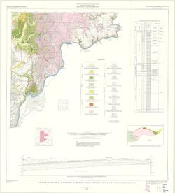
- Subject:
- Topical Subject: Geology, Geographic Subject: Indiana, and Topical Subject: Geology, Stratigraphic
- Creator:
- Gray, Henry Hamilton, 1922- and Indiana. Geological Survey
- Publisher:
- Indiana. Geological Survey
- Date Created:
- 1972
- Identifier:
- VAC3073-M-01255
- Genre:
- Geological cross-sections, Quadrangle maps, and Geological maps
- Geographic Location:
- Coordinates: W0860000 W0844500 N0390000 N0380000
- Related URL:
- Catalog URL: https://iucat.iu.edu/catalog/18454601
- Abstract:
- By Henry H. Gray. Compiled by H. H. Gray and A. M. Burger. Drafted by J. R. Tolen. Base map modified from Army Map Service Map NJ16-6, 1964. Transverse Merca...
- Call Number:
- G4091.C5 s250 .I5 Louisville 1972
- Caption:
- Imprint: [Bloomington, Indiana] : Indiana Geological Survey, 1972
- Physical Description:
- Scale: 1:250,000. Vertical scale approximately 1:11,500 and Dimensions: 66 x 102 cm
- Alternate Identifier:
- Title Control Number: a18454601
- Persistent URL:
- https://purl.dlib.indiana.edu/iudl/images/VAC3073/VAC3073-M-01255
- Provenance:
- Indiana. Geological Survey. Regional geologic map , no. 6.
-
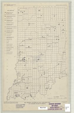
- Subject:
- Topical Subject: Shale gas industry, Topical Subject: Shale, Topical Subject: Ceramic industries, Topical Subject: Clay, Topical Subject: Clay industries, an...
- Creator:
- Murray, Haydn H. (Haydn Herbert), 1924-
- Publisher:
- Indiana. Geological Survey
- Date Created:
- 1952
- Identifier:
- VAC3073-M-00981
- Genre:
- Thematic maps
- Geographic Location:
- Coordinates: W0880000 W0844500 N0414500 N0375200
- Related URL:
- Catalog URL: https://iucat.iu.edu/catalog/8739534
- Abstract:
- "Base from Map of Indiana, 1950 edition, published by U.S. Geological Survey. Minor revisions and additions made from Indiana Department of Conservation...
- Call Number:
- G4091.H5 1952 .M8
- Caption:
- Imprint: [Bloomington, Ind.?] : Indiana Department of Conservation, Geological Survey, 1952.
- Physical Description:
- Dimensions: 45 x 31 cm and Scale: 1:1,000,000
- Alternate Identifier:
- Title Control Number: a8739534
- Persistent URL:
- https://purl.dlib.indiana.edu/iudl/images/VAC3073/VAC3073-M-00981
-
- Subject:
- Geographic Subject: Indiana and Topical Subject: Mines and mineral resources
- Creator:
- Indiana. Geological Survey
- Publisher:
- Indiana. Geological Survey
- Date Created:
- 1953
- Identifier:
- VAC3073-M-01193
- Genre:
- Atlases and Mine maps
- Geographic Location:
- Coordinates: W0880500 W0844700 N0414500 N0374600
- Related URL:
- Catalog URL: https://iucat.iu.edu/catalog/22238
- Abstract:
- Letter inserted indicating map no. 10 last in series,, map dated 1958, letter dated 1962.
- Call Number:
- G1401.H1 A! 1953
- Caption:
- Imprint: Bloomington, Indiana : Indiana Geological Survey, 1953
- Physical Description:
- Dimensions: 56 cm and Scale: Scales differ.
- Persistent URL:
- https://purl.dlib.indiana.edu/iudl/images/VAC3073/VAC3073-M-01193
