
Search Constraints
You searched for:
Publisher
Geological Survey (U.S.)
Remove constraint Publisher: Geological Survey (U.S.)
« Previous |
1 - 100 of 159
|
Next »
Search Results
-
![Vandalia quadrangle, Michigan-Indiana : 15 minute series (topographic) [1973 reprint with vegetation]](https://iiif.uits.iu.edu/iiif/2/0g355j55q%2Ffiles%2F59353208-0771-4acc-8e57-7c989a623800/full/250,/0/default.jpg)
- Subject:
- Topical Subject: Vegetation mapping, Geographic Subject: Saint Joseph County (Mich.), Geographic Subject: Cass County (Mich.), and Geographic Subject: Elkhar...
- Creator:
- Michigan. State Highway Department and Geological Survey (U.S.)
- Publisher:
- Geological Survey (U.S.)
- Date Created:
- 1973
- Identifier:
- VAC3073-M-01507
- Genre:
- 15 minute topographic maps, Quadrangle maps, and Topographic maps
- Geographic Location:
- Coordinates: W0860000 W0854500 N0420000 N0414500
- Related URL:
- Catalog URL: https://iucat.iu.edu/catalog/18415471
- Abstract:
- Mapped, edited, and published by the Geological Survey. Filing title: Vandalia, Mich.-Ind. Standard map series designation: AMS (Series) V762 3867 IV. [Editi...
- Call Number:
- G4090 s62 .G4 Vandalia 1948 V
- Caption:
- Imprint: Washington, D.C. : Interior--U.S. Geological Survey, 1973
- Physical Description:
- Scale: 1:62,500 and Dimensions: 45 x 42 cm or smaller
- Alternate Identifier:
- Title Control Number: a18415471
- Persistent URL:
- https://purl.dlib.indiana.edu/iudl/images/VAC3073/VAC3073-M-01507
- Provenance:
- Part of Geological Survey (U.S.). Indiana 1:62,500.
-
![Vandalia quadrangle, Michigan-Indiana : 15 minute series (topographic) [1959 reprint without vegetation]](https://iiif.uits.iu.edu/iiif/2/9593vz28s%2Ffiles%2F4f6d2df8-a9b9-45fc-993f-1949cda1ffbb/full/250,/0/default.jpg)
- Subject:
- Geographic Subject: Saint Joseph County (Mich.), Geographic Subject: Elkhart County (Ind.), and Geographic Subject: Cass County (Mich.)
- Creator:
- Geological Survey (U.S.) and Michigan. State Highway Department
- Publisher:
- Geological Survey (U.S.)
- Date Created:
- 1959
- Identifier:
- VAC3073-M-01506
- Genre:
- 15 minute topographic maps, Quadrangle maps, and Topographic maps
- Geographic Location:
- Coordinates: W0860000 W0854500 N0420000 N0414500
- Related URL:
- Catalog URL: https://iucat.iu.edu/catalog/18415471
- Abstract:
- Mapped, edited, and published by the Geological Survey. Filing title: Vandalia, Mich.-Ind. Standard map series designation: AMS (Series) V762 3867 IV. [Editi...
- Call Number:
- G4090 s62 .G4 Vandalia 1948
- Caption:
- Imprint: Washington, D.C. : Interior--U.S. Geological Survey, [1959]
- Physical Description:
- Scale: 1:62,500 and Dimensions: 45 x 42 cm or smaller
- Alternate Identifier:
- Title Control Number: a18415471
- Persistent URL:
- https://purl.dlib.indiana.edu/iudl/images/VAC3073/VAC3073-M-01506
- Provenance:
- Part of Geological Survey (U.S.). Indiana 1:62,500.
-
![Vandalia quadrangle, Michigan-Indiana : 15 minute series (topographic) [1959 reprint with vegetation]](https://iiif.uits.iu.edu/iiif/2/9019t543m%2Ffiles%2Fd71ad7ee-44b6-4efe-9cbc-388b2c880604/full/250,/0/default.jpg)
- Subject:
- Geographic Subject: Saint Joseph County (Mich.), Geographic Subject: Cass County (Mich.), Topical Subject: Vegetation mapping, and Geographic Subject: Elkhar...
- Creator:
- Geological Survey (U.S.) and Michigan. State Highway Department
- Publisher:
- Geological Survey (U.S.)
- Date Created:
- 1959
- Identifier:
- VAC3073-M-01337
- Genre:
- 15 minute topographic maps, Topographic maps, and Quadrangle maps
- Geographic Location:
- Coordinates: W0860000 W0854500 N0420000 N0414500
- Related URL:
- Catalog URL: https://iucat.iu.edu/catalog/18415471
- Abstract:
- Mapped, edited, and published by the Geological Survey. Filing title: Vandalia, Mich.-Ind. Standard map series designation: AMS (Series) V762 3867 IV. [Editi...
- Call Number:
- G4090 s62 .G4 Vandalia 1948 rep 1959 V
- Caption:
- Imprint: Washington, D.C. : Interior--U.S. Geological Survey, 1959
- Physical Description:
- Dimensions: 45 x 42 cm or smaller and Scale: 1:62,500
- Alternate Identifier:
- Title Control Number: a18415471
- Persistent URL:
- https://purl.dlib.indiana.edu/iudl/images/VAC3073/VAC3073-M-01337
- Provenance:
- Part of Geological Survey (U.S.). Indiana 1:62,500.
-
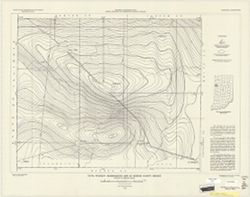
- Subject:
- Topical Subject: Geomagnetism and Geographic Subject: Saint Joseph County (Ind.)
- Creator:
- Dempsey, W. J.
- Publisher:
- Geological Survey (U.S.)
- Date Created:
- 1949
- Identifier:
- VAC3073-M-00321
- Genre:
- Thematic maps
- Geographic Location:
- Coordinates: W0863135 W0860333 N0414538 N0412601
- Related URL:
- Catalog URL: https://iucat.iu.edu/catalog/8177219
- Abstract:
- Includes text and location map.
- Call Number:
- G4093.S2C93 1950 .D4
- Caption:
- Imprint: [Washington, D.C.] : For sale by U.S. Geological Survey, 1950
- Physical Description:
- Dimensions: 60 x 74 cm and Scale: Approximately 1:64,000
- Alternate Identifier:
- Title Control Number: a8177219
- Persistent URL:
- https://purl.dlib.indiana.edu/iudl/images/VAC3073/VAC3073-M-00321
-
- Subject:
- Topical Subject: Geomagnetism and Geographic Subject: Fulton County (Ind.)
- Creator:
- Dempsey, W. J.
- Publisher:
- Geological Survey (U.S.)
- Date Created:
- 1949
- Identifier:
- VAC3073-M-00853
- Genre:
- Thematic maps
- Geographic Location:
- Coordinates: W0862806 W0855643 N0411022 N0405432
- Related URL:
- Catalog URL: https://iucat.iu.edu/catalog/6942523
- Abstract:
- Includes text and location map.
- Call Number:
- G4093.F8C93 1949 .D4
- Caption:
- Imprint: [Washington, D.C.] : For sale by U.S. Geological Survey, 1949.
- Physical Description:
- Dimensions: 48 x 71 cm and Scale: 1:75,600
- Alternate Identifier:
- Title Control Number: a6942523
- Persistent URL:
- https://purl.dlib.indiana.edu/iudl/images/VAC3073/VAC3073-M-00853
-
- Subject:
- Geographic Subject: Elkhart County (Ind.) and Topical Subject: Geomagnetism
- Creator:
- Dempsey, W. J.
- Publisher:
- Geological Survey (U.S.)
- Date Created:
- 1950
- Identifier:
- VAC3073-M-00707
- Genre:
- Thematic maps
- Geographic Location:
- Coordinates: W0860345 W0853912 N0414537 N0412605
- Related URL:
- Catalog URL: https://iucat.iu.edu/catalog/8177225
- Abstract:
- Includes text and location map.
- Call Number:
- G4093.E4C93 1950 .D4
- Caption:
- Imprint: [Washington, D.C.] : For sale by U.S. Geological Survey, 1950.
- Physical Description:
- Dimensions: 60 x 66 cm and Scale: 1:63,500
- Alternate Identifier:
- Title Control Number: a8177225
- Persistent URL:
- https://purl.dlib.indiana.edu/iudl/images/VAC3073/VAC3073-M-00707
-
- Subject:
- Topical Subject: Geomagnetism and Geographic Subject: Dubois County (Ind.)
- Creator:
- Henderson, John R.
- Publisher:
- Geological Survey (U.S.)
- Date Created:
- 1950
- Identifier:
- VAC3073-M-00835
- Genre:
- Geological maps and Thematic maps
- Geographic Location:
- Coordinates: W0870423 W0864044 N0383135 N0381210
- Related URL:
- Catalog URL: https://iucat.iu.edu/catalog/8174197
- Abstract:
- Includes text and location map.
- Call Number:
- G4093.D8C93 1950 .H46
- Caption:
- Imprint: [Washington, D.C.] : U.S. Geological Survey, 1950.
- Physical Description:
- Scale: 1:63,360 and Dimensions: 57 x 64 cm
- Alternate Identifier:
- Title Control Number: a8174197
- Persistent URL:
- https://purl.dlib.indiana.edu/iudl/images/VAC3073/VAC3073-M-00835
-
- Subject:
- Topical Subject: Geomagnetism and Geographic Subject: Benton County (Ind.)
- Creator:
- Geological Survey (U.S.)
- Publisher:
- Geological Survey (U.S.)
- Date Created:
- 1949
- Identifier:
- VAC3073-M-00829
- Genre:
- Thematic maps and Geological maps
- Geographic Location:
- Coordinates: W0873135 W0870536 N0404413 N0402832
- Related URL:
- Catalog URL: https://iucat.iu.edu/catalog/9061555
- Abstract:
- Includes text and location map.
- Call Number:
- G4093.B4C93 1949 .G46
- Caption:
- Imprint: [Washington, D.C.] : For sale by U.S. Geological Survey, 1949.
- Physical Description:
- Dimensions: 59 x 75 cm and Scale: 1:63360.
- Alternate Identifier:
- Title Control Number: a9061555
- Persistent URL:
- https://purl.dlib.indiana.edu/iudl/images/VAC3073/VAC3073-M-00829
-
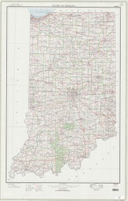
- Subject:
- Geographic Subject: Indiana
- Creator:
- Geological Survey (U.S.)
- Publisher:
- Geological Survey (U.S.)
- Date Created:
- 1914
- Identifier:
- VAC3073-M-01290
- Genre:
- Topographic maps
- Geographic Location:
- Coordinates: W0880700 W0844500 N0414500 N0375200
- Related URL:
- Catalog URL: https://iucat.iu.edu/catalog/11839670
- Abstract:
- Relief shown by contours. Contour interval 100 feet. "Base from U.S. Geological Survey 1:1,000,000 scale map of the United States now in prep...
- Call Number:
- G4090 1914 .G4
- Caption:
- Imprint: [Washington, D.C.] : U.S. Geological Survey, 1914
- Physical Description:
- Dimensions: 46 x 31 cm and Scale: 1:1,000,000
- Persistent URL:
- https://purl.dlib.indiana.edu/iudl/images/VAC3073/VAC3073-M-01290
-
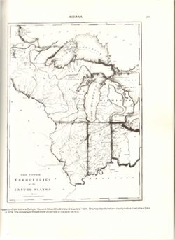
- Subject:
- Geographic Subject: Middle West
- Creator:
- Carey, Mathew, 1760-1839
- Publisher:
- Geological Survey (U.S.)
- Date Created:
- 1988
- Identifier:
- VAC3073-M-00315
- Genre:
- Early maps and Facsimiles
- Geographic Location:
- Coordinates: W0960000 W0810000 N0500000 N0360000
- Related URL:
- Catalog URL: https://iucat.iu.edu/catalog/18416533
- Abstract:
- Relief shown by hachures. Prime meridians: London and Philadelphia. Reprint of: The Upper territories of the United States. In General atlas of the world and...
- Call Number:
- QH75 .A4 No. 1200-IN
- Caption:
- Imprint: [Reston, Va.] : [The Survey], [1988]
- Physical Description:
- Dimensions: 29 cm or less and Scale: Indeterminable
- Alternate Identifier:
- Title Control Number: a18416533 and Alternate ID: 358171IP
- Persistent URL:
- https://purl.dlib.indiana.edu/iudl/images/VAC3073/VAC3073-M-00315
- Provenance:
- The National gazetteer of the United States of America--Indiana, 1988 / U.S. Geological Survey.
-
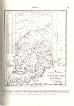
- Subject:
- Topical Subject: Potawatomi Tribe, Geographic Subject: Indiana, Topical Subject: Miami Tribe, Topical Subject: Transportation, Topical Subject: Rivers, and G...
- Creator:
- Tanner, Henry Schenck, 1786-1858
- Publisher:
- Geological Survey (U.S.)
- Date Created:
- 1988
- Identifier:
- VAC3073-M-00095
- Genre:
- Tourist maps, Geological cross-sections, and Maps
- Geographic Location:
- Coordinates: W0880500 W0834600 N0415000 N0374600
- Related URL:
- Catalog URL: https://iucat.iu.edu/catalog/18437130
- Abstract:
- Variant title: Travellers pocket map of Indiana with its roads and distances. Relief shown by profile. Shows existing and proposed canals and railroads as we...
- Call Number:
- QH75 .A4 No. 1200-IN
- Caption:
- Imprint: ©18 April, 1831, Imprint: Philadelphia : H.S. Tanner, 18 April, 1831, and Imprint: [Reston, Va.] : [U.S. Geological Survey], [1988]
- Physical Description:
- Scale: Indeterminable. Vertical scale indeterminable and Dimensions: 29 cm or smaller
- Alternate Identifier:
- Alternate ID: 358171IP and Title Control Number: a18437130
- Persistent URL:
- https://purl.dlib.indiana.edu/iudl/images/VAC3073/VAC3073-M-00095
- Provenance:
- The National gazetteer of the United States of America--Indiana, 1988 / U.S. Geological Survey.
-
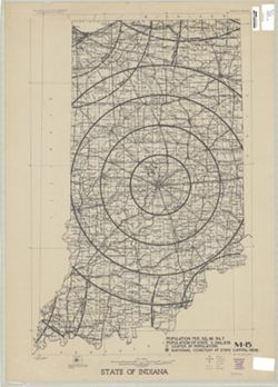
- Subject:
- Geographic Subject: Indiana and Topical Subject: Maps
- Creator:
- Geological Survey (U.S.)
- Publisher:
- Geological Survey (U.S.)
- Date Created:
- 1973
- Identifier:
- VAC3073-M-00367
- Genre:
- Topographic maps
- Geographic Location:
- Coordinates: W0880700 W0844500 N0414500 N0374600
- Related URL:
- Catalog URL: https://iucat.iu.edu/catalog/13903794
- Abstract:
- Compiled in 1970. Includes population key. Source data U.S. Dept. of the Interior - Geological Survey topographic maps. U.S. Dept of the Army - Corps of Engi...
- Call Number:
- G4091.C2 1973 .G4
- Caption:
- Imprint: [Reston, Va.] : U.S. Geological Survey, 1973
- Physical Description:
- Dimensions: 91 x 59 cm and Scale: 1:500,000
- Alternate Identifier:
- Title Control Number: a5297954
- Persistent URL:
- https://purl.dlib.indiana.edu/iudl/images/VAC3073/VAC3073-M-00367
-
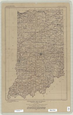
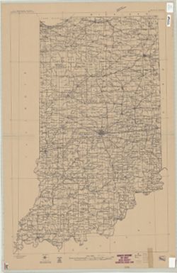
- Subject:
- Geographic Subject: Indiana
- Creator:
- Geological Survey (U.S.)
- Publisher:
- Geological Survey (U.S.)
- Date Created:
- 1950
- Identifier:
- VAC3073-M-00311
- Genre:
- Thematic maps
- Geographic Location:
- Coordinates: W0880700 W0844700 N0414500 N0374600
- Related URL:
- Catalog URL: https://iucat.iu.edu/catalog/2256717
- Abstract:
- "Printed 1950"--Margin.
- Call Number:
- G4091 .A1 1950 .G4
- Caption:
- Imprint: Washington, D.C.: The Survey, 1950.
- Physical Description:
- Dimensions: 91 x 58 cm, on sheet 108 x 69 cm and Scale: 1:500,000
- Alternate Identifier:
- Title Control Number: BGY3152BB
- Persistent URL:
- https://purl.dlib.indiana.edu/iudl/images/VAC3073/VAC3073-M-00311
-
- Subject:
- Geographic Subject: Indiana
- Creator:
- Geological Survey (U.S.)
- Publisher:
- Geological Survey (U.S.)
- Date Created:
- Circa 1912
- Identifier:
- VAC3073-M-01292
- Genre:
- Maps
- Geographic Location:
- Coordinates: W0880700 W0844500 N0414500 N0375200
- Related URL:
- Catalog URL: https://iucat.iu.edu/catalog/6087422
- Abstract:
- "Compiled in 1909-1910." Stamped in upper margin: "Advance sheet. Subject to correction." Includes diagram showing the "Re...
- Call Number:
- G4090 1910 .G4
- Caption:
- Imprint: [Washington, D.C.] : U.S. Geological Survey, [1912?]
- Physical Description:
- Dimensions: 92 x 60 cm and Scale: 1:500,000
- Persistent URL:
- https://purl.dlib.indiana.edu/iudl/images/VAC3073/VAC3073-M-01292
-
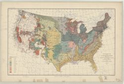
- Subject:
- Geographic Subject: United States and Topical Subject: Geology
- Creator:
- McGee, W J, 1853-1912
- Publisher:
- Geological Survey (U.S.)
- Date Created:
- 1893
- Identifier:
- VAC3073-M-00861
- Genre:
- Geological maps
- Geographic Location:
- Coordinates: W1250000 W0670000 N0490000 N0250000
- Related URL:
- Catalog URL: https://iucat.iu.edu/catalog/8556458
- Abstract:
- Relief shown by contour lines. In upper border: U.S. Geological Survey. Fourteenth annual report, pl. II. Shows Indian reservations. Includes legend.
- Call Number:
- G3701.C51 1893 .G46
- Caption:
- Imprint: [Washington?] : U.S. Geological Survey, 1893.
- Physical Description:
- Dimensions: 43 x 71 cm and Scale: 1:7,000,000
- Alternate Identifier:
- Title Control Number: a8556458
- Persistent URL:
- https://purl.dlib.indiana.edu/iudl/images/VAC3073/VAC3073-M-00861
- Provenance:
- 14th Annual Report (1884) / Indiana. Department of Geology and Natural History.
-
![Princeton quadrangle, Indiana-Illinois : 15 minute series (topographic) [1965 reprint with vegetation]](https://iiif.uits.iu.edu/iiif/2/sx61fr138%2Ffiles%2F603798b1-0337-482a-9bb7-934a41ad4b2b/full/250,/0/default.jpg)
- Subject:
- Geographic Subject: Knox County (Ind.), Geographic Subject: Wabash County (Ill.), Topical Subject: Vegetation mapping, and Geographic Subject: Gibson County ...
- Creator:
- Geological Survey (U.S.), Illinois State Geological Survey, and United States. Army Map Service
- Publisher:
- Geological Survey (U.S.)
- Date Created:
- 1965
- Identifier:
- VAC3073-M-01388
- Genre:
- 15 minute topographic maps, Quadrangle maps, and Topographic maps
- Geographic Location:
- Coordinates: W0874500 W0873000 N0383000 N0381500
- Related URL:
- Catalog URL: https://iucat.iu.edu/catalog/18413928
- Abstract:
- Mapped, edited and published by the Geological Survey , Illinois area mapped in cooperation with State of Illinois Geological Survey. Filing title: Princeton...
- Call Number:
- G4090 s62 .G4 Princeton 1959 rep1965 V
- Caption:
- Imprint: Washington, D.C. : Interior--U.S. Geological Survey, 1965.
- Physical Description:
- Dimensions: 45 x 42 cm or smaller and Scale: 1:62,500
- Alternate Identifier:
- Title Control Number: a18413928
- Persistent URL:
- https://purl.dlib.indiana.edu/iudl/images/VAC3073/VAC3073-M-01388
- Provenance:
- Part of Geological Survey (U.S.). Indiana 1:62,500.
-
![Princeton quadrangle, Indiana-Illinois : 15 minute series (topographic) [1965 reprint with vegetation]](https://iiif.uits.iu.edu/iiif/2/7m01cp47j%2Ffiles%2Fdc826735-24b7-4c3f-9d9b-87ad67efd7e8/full/250,/0/default.jpg)
- Subject:
- Geographic Subject: Gibson County (Ind.), Geographic Subject: Knox County (Ind.), Geographic Subject: Wabash County (Ill.), and Topical Subject: Vegetation m...
- Creator:
- Geological Survey (U.S.), United States. Army Map Service, and Illinois State Geological Survey
- Publisher:
- Geological Survey (U.S.)
- Date Created:
- 1965
- Identifier:
- VAC3073-M-01504
- Genre:
- Topographic maps, 15 minute topographic maps, and Quadrangle maps
- Geographic Location:
- Coordinates: W0874500 W0873000 N0383000 N0381500
- Related URL:
- Catalog URL: https://iucat.iu.edu/catalog/18413928
- Abstract:
- Mapped, edited and published by the Geological Survey , Illinois area mapped in cooperation with State of Illinois Geological Survey. Filing title: Princeton...
- Call Number:
- G4090 s62 .G4 Princeton 1959 V
- Caption:
- Imprint: Washington, D.C. : Interior--U.S. Geological Survey, 1965
- Physical Description:
- Scale: 1:62,500 and Dimensions: 45 x 42 cm or smaller
- Alternate Identifier:
- Title Control Number: a18413928
- Persistent URL:
- https://purl.dlib.indiana.edu/iudl/images/VAC3073/VAC3073-M-01504
- Provenance:
- Part of Geological Survey (U.S.). Indiana 1:62,500.
-
![Princeton quadrangle, Indiana-Illinois : 15 minute series (topographic) [1965 printing without vegetation]](https://iiif.uits.iu.edu/iiif/2/70796d47m%2Ffiles%2Fedc5c6d4-9f41-4b7c-9447-a370bfe906e0/full/250,/0/default.jpg)
- Subject:
- Geographic Subject: Knox County (Ind.), Geographic Subject: Gibson County (Ind.), and Geographic Subject: Wabash County (Ill.)
- Creator:
- Illinois State Geological Survey, United States. Army Map Service, and Geological Survey (U.S.)
- Publisher:
- Geological Survey (U.S.)
- Date Created:
- 1965
- Identifier:
- VAC3073-M-01503
- Genre:
- Quadrangle maps, 15 minute topographic maps, and Topographic maps
- Geographic Location:
- Coordinates: W0874500 W0873000 N0383000 N0381500
- Related URL:
- Catalog URL: https://iucat.iu.edu/catalog/18413928
- Abstract:
- Mapped, edited and published by the Geological Survey , Illinois area mapped in cooperation with State of Illinois Geological Survey. Filing title: Princeton...
- Call Number:
- G4090 s62 .G4 Princeton 1959
- Caption:
- Imprint: Washington, D.C. : Interior--U.S. Geological Survey, 1964.
- Physical Description:
- Dimensions: 45 x 42 cm or smaller and Scale: 1:62,500
- Alternate Identifier:
- Title Control Number: a18413928
- Persistent URL:
- https://purl.dlib.indiana.edu/iudl/images/VAC3073/VAC3073-M-01503
- Provenance:
- Part of Geological Survey (U.S.). Indiana 1:62,500.
-
![Princeton quadrangle, Indiana-Illinois : 15 minute series (topographic) [1964 printing with vegetation]](https://iiif.uits.iu.edu/iiif/2/m900px89p%2Ffiles%2Fe957c77d-db8c-42d6-aef0-05abd0d3301b/full/250,/0/default.jpg)
- Subject:
- Geographic Subject: Gibson County (Ind.), Topical Subject: Vegetation mapping, Geographic Subject: Wabash County (Ill.), and Geographic Subject: Knox County ...
- Creator:
- Geological Survey (U.S.), United States. Army Map Service, and Illinois State Geological Survey
- Publisher:
- Geological Survey (U.S.)
- Date Created:
- 1964
- Identifier:
- VAC3073-M-01387
- Genre:
- Quadrangle maps, 15 minute topographic maps, and Topographic maps
- Geographic Location:
- Coordinates: W0874500 W0873000 N0383000 N0381500
- Related URL:
- Catalog URL: https://iucat.iu.edu/catalog/18413928
- Abstract:
- Mapped, edited and published by the Geological Survey , Illinois area mapped in cooperation with State of Illinois Geological Survey. Filing title: Princeton...
- Call Number:
- G4090 s62 .G4 1959 rep1964 V
- Caption:
- Imprint: Washington, D.C. : Interior--U.S. Geological Survey, 1964
- Physical Description:
- Dimensions: 45 x 42 cm or smaller and Scale: 1:62,500
- Alternate Identifier:
- Title Control Number: a18413928
- Persistent URL:
- https://purl.dlib.indiana.edu/iudl/images/VAC3073/VAC3073-M-01387
- Provenance:
- Part of Geological Survey (U.S.). Indiana 1:62,500.
-
![Princeton quadrangle, Indiana-Illinois : 15 minute series (topographic) [1964 printing with vegetation]](https://iiif.uits.iu.edu/iiif/2/ng452m35w%2Ffiles%2F49af6c65-fc22-44ea-8486-c7923f5afb8b/full/250,/0/default.jpg)
- Subject:
- Geographic Subject: Knox County (Ind.), Geographic Subject: Gibson County (Ind.), Geographic Subject: Wabash County (Ill.), and Topical Subject: Vegetation m...
- Creator:
- Illinois State Geological Survey, Geological Survey (U.S.), and United States. Army Map Service
- Publisher:
- Geological Survey (U.S.)
- Date Created:
- 1964
- Identifier:
- VAC3073-M-01386
- Genre:
- 15 minute topographic maps, Topographic maps, and Quadrangle maps
- Geographic Location:
- Coordinates: W0874500 W0873000 N0383000 N0381500
- Related URL:
- Catalog URL: https://iucat.iu.edu/catalog/18413928
- Abstract:
- Mapped, edited and published by the Geological Survey , Illinois area mapped in cooperation with State of Illinois Geological Survey. Filing title: Princeton...
- Call Number:
- G4090 s62 .G4 Princeton 1959 rep1964
- Caption:
- Imprint: Washington, D.C. : Interior--U.S. Geological Survey, 1964
- Physical Description:
- Scale: 1:62,500 and Dimensions: 45 x 42 cm or smaller
- Alternate Identifier:
- Title Control Number: a18413928
- Persistent URL:
- https://purl.dlib.indiana.edu/iudl/images/VAC3073/VAC3073-M-01386
- Provenance:
- Part of Geological Survey (U.S.). Indiana 1:62,500.
-
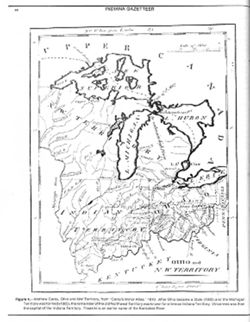
- Subject:
- Geographic Subject: Northwest, Old and Geographic Subject: Ohio
- Creator:
- Barker, W. (William), active 1795-1803 and Carey, Mathew, 1760-1839
- Publisher:
- Geological Survey (U.S.)
- Date Created:
- 1988
- Identifier:
- VAC3073-M-00004
- Genre:
- Early maps and Facsimiles
- Geographic Location:
- Coordinates: W0921900 W0794100 N0490000 N0374200
- Related URL:
- Catalog URL: https://iucat.iu.edu/catalog/18416531
- Abstract:
- Other title: Ohio and Northwest Territory. Prime meridians: London and Philadelphia. Reprint of: Ohio and N. W. Territory. In Carey's minor atlas / Carey...
- Call Number:
- QH75 .A4 No. 1200-IN
- Caption:
- Imprint: [Reston, Va.] : [The Survey], [1988]
- Physical Description:
- Scale: Indeterminable and Dimensions: 29 cm or smaller
- Alternate Identifier:
- Title Control Number: a18416531 and Alternate ID: 358171IP
- Persistent URL:
- https://purl.dlib.indiana.edu/iudl/images/VAC3073/VAC3073-M-00004
- Provenance:
- The National gazetteer of the United States of America--Indiana, 1988 / U.S. Geological Survey.
-
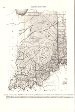
- Subject:
- Topical Subject: Potawatomi Tribe, Geographic Subject: Indiana, and Topical Subject: Kickapoo Tribe of Indians
- Creator:
- Tanner, Henry Schenck, 1786-1858
- Publisher:
- Geological Survey (U.S.)
- Date Created:
- 1988
- Identifier:
- VAC3073-M-00296
- Genre:
- Maps
- Geographic Location:
- Coordinates: W0880558 W0842342 N0414540 N0374618
- Related URL:
- Catalog URL: https://iucat.iu.edu/catalog/18454603
- Abstract:
- Title from caption. Statement of responsibility from caption. Shows areas of Indiana held by the Potawatomi and Kickapoo tribes. "Figure 6.--Indiana por...
- Call Number:
- QE75 .A4 No. 1200-IN
- Caption:
- Imprint: [Reston, Va.] : [U.S. Geological Survey], [1988]
- Physical Description:
- Scale: Indeterminable and Dimensions: 29 cm or smaller
- Alternate Identifier:
- Title Control Number: a18454603 and Alternate ID: 358171IP
- Persistent URL:
- https://purl.dlib.indiana.edu/iudl/images/VAC3073/VAC3073-M-00296
- Provenance:
- The National gazetteer of the United States of America--Indiana, 1988 / U.S. Geological Survey.
-
- Subject:
- Geographic Subject: Berrien County (Mich.), Topical Subject: Vegetation mapping, and Geographic Subject: Saint Joseph County (Ind.)
- Creator:
- United States. Army Map Service
- Publisher:
- Geological Survey (U.S.)
- Date Created:
- 1943
- Identifier:
- VAC3073-M-01364
- Genre:
- 15 minute topographic maps, Quadrangle maps, Topographic maps, and Photogrammetric maps
- Geographic Location:
- Coordinates: W0863000 W0861500 N0420000 N0414500
- Related URL:
- Catalog URL: https://iucat.iu.edu/catalog/18413123
- Abstract:
- Prepared under the direction of the Chief of Engineers, U. S. Army, 1943. Army Map Service, Quincy unit. At head of map: Michigan 1:62,500. Filing title: Nil...
- Call Number:
- G4090 s62 .G4 Niles 1943
- Caption:
- Imprint: Washington, D.C. : Army Map Service, U.S. Army, 1943
- Physical Description:
- Scale: 1:62,500 and Dimensions: 45 x 42 cm or smaller
- Alternate Identifier:
- Title Control Number: a18413123
- Persistent URL:
- https://purl.dlib.indiana.edu/iudl/images/VAC3073/VAC3073-M-01364
- Provenance:
- Part of Geological Survey (U.S.). Indiana 1:62,500.
-
![New Harmony quadrangle, Indiana--Illinois, 1959 : 15 minute series (topographic) [1963 reprint with vegetation]](https://iiif.uits.iu.edu/iiif/2/n296z235w%2Ffiles%2Faf8714ac-51b2-4e50-bb3a-3e3e07d338a7/full/250,/0/default.jpg)
- Subject:
- Topical Subject: Vegetation mapping, Geographic Subject: Gibson County (Ind.), Geographic Subject: Posey County (Ind.), and Geographic Subject: White County ...
- Creator:
- Geological Survey (U.S.) and Illinois State Geological Survey
- Publisher:
- Geological Survey (U.S.)
- Date Created:
- 1963
- Identifier:
- VAC3073-M-01356
- Genre:
- Topographic maps, Quadrangle maps, and 15 minute topographic maps
- Geographic Location:
- Coordinates: W0880000 W0874500 N0381500 N0380000
- Related URL:
- Catalog URL: https://iucat.iu.edu/catalog/18412809
- Abstract:
- Mapped, edited, and published by the Geological Survey , Illinois area mapped in cooperation with State of Illinois Geological Survey. Filing title: New Harm...
- Call Number:
- G4090 s62 .G4 New Harmony 1959 rep 1963 V
- Caption:
- Imprint: Washington, D.C. : Interior--U.S. Geological Survey, 1963.
- Physical Description:
- Scale: 1:62,500 and Dimensions: 45 x 42 cm or smaller
- Alternate Identifier:
- Title Control Number: a18412809
- Persistent URL:
- https://purl.dlib.indiana.edu/iudl/images/VAC3073/VAC3073-M-01356
- Provenance:
- Part of Geological Survey (U.S.). Indiana 1:62,500.
-
- Subject:
- Geographic Subject: Edwards County (Ill.), Geographic Subject: Gibson County (Ind.), Geographic Subject: Wabash County (Ill.), and Topical Subject: Vegetatio...
- Creator:
- Geological Survey (U.S.)
- Publisher:
- Geological Survey (U.S.)
- Date Created:
- 1963
- Identifier:
- VAC3073-M-01353
- Genre:
- 15 minute topographic maps, Quadrangle maps, and Topographic maps
- Geographic Location:
- Coordinates: W0880000 W0874500 N0383000 N0381500
- Related URL:
- Catalog URL: https://iucat.iu.edu/catalog/18412729
- Abstract:
- Mapped, edited, and published by the Geological Survey. Filing title: Mount Carmel, Ill.-Ind. Standard map series designation: AMS (Series) V763 3460 IV. Pol...
- Call Number:
- G4090 s62 .G4 Mount Carmel 1959 rep 1963 V
- Caption:
- Imprint: Washington, D.C. : The Survey, 1963.
- Physical Description:
- Dimensions: 45 x 42 cm or smaller and Scale: 1:62,500
- Alternate Identifier:
- Title Control Number: a18412729
- Persistent URL:
- https://purl.dlib.indiana.edu/iudl/images/VAC3073/VAC3073-M-01353
- Provenance:
- Part of Geological Survey (U.S.). Indiana 1:62,500.
-
![Michigan-Indiana Three Rivers quadrangle [1932 reprint]](https://iiif.uits.iu.edu/iiif/2/qb98nk04b%2Ffiles%2F296eac80-9a56-4522-add9-e4bc7783d601/full/250,/0/default.jpg)
- Subject:
- Geographic Subject: LaGrange County (Ind.), Geographic Subject: Saint Joseph County (Mich.), and Geographic Subject: Elkhart County (Ind.)
- Creator:
- Lee, L. L. (Luria Lyons), 1882-1962, Burney, H. E., U.S. Lake Survey, Herron, W. H. (William Harrison), 1865-, Geological Survey (U.S.), Marshall, R. B. (Rob...
- Publisher:
- Geological Survey (U.S.)
- Date Created:
- 1932
- Identifier:
- VAC3073-M-01396
- Genre:
- 15 minute topographic maps, Topographic maps, and Quadrangle maps
- Geographic Location:
- Coordinates: W0854500 W0853000 N0420000 N0414500
- Related URL:
- Catalog URL: https://iucat.iu.edu/catalog/18416001
- Abstract:
- R.B. Marshall, chief geographer , W.H. Herron, geographer in charge , topography by L.L. Lee and H.E. Burney , control by U.S. Lake Survey, J.R. Ellis, J.H. ...
- Call Number:
- G4090 s62 .G4 Three Rivers 1916 rep1932
- Caption:
- Imprint: Washington, D.C. : Dept. of the Interior, U.S. Geological Survey, 1932
- Physical Description:
- Scale: 1:62,500 and Dimensions: 45 x 42 cm or smaller
- Alternate Identifier:
- Title Control Number: a18416001
- Persistent URL:
- https://purl.dlib.indiana.edu/iudl/images/VAC3073/VAC3073-M-01396
- Provenance:
- Part of Geological Survey (U.S.). Indiana 1:62,500.
-
![Michigan-Indiana Three Oaks quadrangle [1930 printing]](https://iiif.uits.iu.edu/iiif/2/s1785q22x%2Ffiles%2Fdf050288-4fd9-4056-bb9e-e2b44d32511e/full/250,/0/default.jpg)
- Subject:
- Geographic Subject: Saint Joseph County (Ind.), Geographic Subject: Berrien County (Mich.), and Geographic Subject: LaPorte County (Ind.)
- Creator:
- Geological Survey (U.S.), Michigan. Geological Survey Division, Plushnick, A. W. (Andrew Winfield), 1898-1980, Gehres, W. S. (Wilmer Sherman), 1887-1963, and...
- Publisher:
- Geological Survey (U.S.)
- Date Created:
- 1930
- Identifier:
- VAC3073-M-01395
- Genre:
- Topographic maps, 15 minute topographic maps, and Quadrangle maps
- Geographic Location:
- Coordinates: W0865000 W0863000 N0420000 N0414500
- Related URL:
- Catalog URL: https://iucat.iu.edu/catalog/18413989
- Abstract:
- Topography by W.S. Gehres and A.W. Plushnick , culture and drainage in part compiled from aerial photographs taken by Air Corps, U.S. Army , control by U.S. ...
- Call Number:
- G4090 s62 .G4 Three Oaks 1930
- Caption:
- Imprint: Washington, D.C. : U.S. Geological Survey, [1930]
- Physical Description:
- Scale: 1:62,500 and Dimensions: 45 x 42 cm or smaller
- Alternate Identifier:
- Title Control Number: a18413989
- Persistent URL:
- https://purl.dlib.indiana.edu/iudl/images/VAC3073/VAC3073-M-01395
- Provenance:
- Part of Geological Survey (U.S.). Indiana 1:62,500.
-
- Subject:
- Geographic Subject: Berrien County (Mich.) and Geographic Subject: Saint Joseph County (Ind.)
- Creator:
- Gehres, W. S. (Wilmer Sherman), 1887-1963, Geological Survey (U.S.), Plushnick, A. W. (Andrew Winfield), 1898-1980, U.S. Lake Survey, Michigan. Geological Su...
- Publisher:
- Geological Survey (U.S.)
- Date Created:
- 1930
- Identifier:
- VAC3073-M-01363
- Genre:
- 15 minute topographic maps, Quadrangle maps, and Topographic maps
- Geographic Location:
- Coordinates: W0863000 W0861500 N0420000 N0414500
- Related URL:
- Catalog URL: https://iucat.iu.edu/catalog/18413855
- Abstract:
- Topography by W.S. Gehres and A.W. Plushnick. Filing title: Niles, Mich.-Ind. Edition of 1930. Polyconic projection. Relief shown by contours and spot height...
- Call Number:
- G4090 s62 .G4 Niles 1930
- Caption:
- Imprint: Washington, D.C. : Dept. of the Interior, U.S. Geological Survey, 1930
- Physical Description:
- Dimensions: 45 x 42 cm or smaller and Scale: 1:62,500
- Alternate Identifier:
- Title Control Number: a18413855
- Persistent URL:
- https://purl.dlib.indiana.edu/iudl/images/VAC3073/VAC3073-M-01363
- Provenance:
- Part of Geological Survey (U.S.). Indiana 1:62,500.
-
- Subject:
- Geographic Subject: Virginia, Geographic Subject: United States, and Topical Subject: Indians of North America
- Creator:
- Sabin, Joseph, 1821-1881 and Washington, George, 1732-1799
- Publisher:
- Geological Survey (U.S.)
- Date Created:
- 1988
- Identifier:
- VAC3073-M-00372
- Genre:
- Early maps
- Geographic Location:
- Coordinates: W0923500 W0750000 N0440000 N0360000
- Related URL:
- Catalog URL: https://iucat.iu.edu/catalog/18454608
- Abstract:
- Variant tile: Map of the western parts of the colony of Virginia, as far as the Mississippi. Relief shown pictorially. Prime meridians: London and Ferro. &qu...
- Call Number:
- QH75 .A4 No. 1200-IN
- Caption:
- Imprint: [Reston, Va.] : [U.S. Geological Survey], [1988]
- Physical Description:
- Scale: Scale not given. and Dimensions: 29 cm or smaller
- Alternate Identifier:
- Alternate ID: 358171IP and Title Control Number: a18454608
- Persistent URL:
- https://purl.dlib.indiana.edu/iudl/images/VAC3073/VAC3073-M-00372
- Provenance:
- Map of the Western parts of the Colony of Virginia as far as the Mississipi.
-
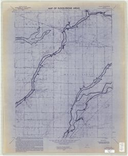
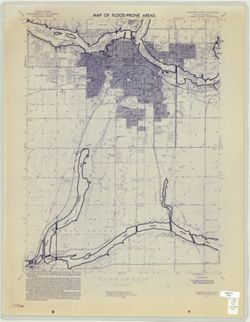
- Subject:
- Topical Subject: Flood forecasting, Geographic Subject: Knox County (Ind.), Topical Subject: Floodplains, Geographic Subject: Daviess County (Ind.), and Topi...
- Creator:
- Geological Survey (U.S.)
- Publisher:
- Geological Survey (U.S.)
- Date Created:
- 1970
- Identifier:
- VAC3073-M-00649
- Genre:
- Thematic maps
- Geographic Location:
- Coordinates: W0872230 W0871500 N0384500 N0383730
- Related URL:
- Catalog URL: https://iucat.iu.edu/catalog/18416340
- Abstract:
- Filing title: Wheatland, Ind. Relief shown by contours and spot heights. Contour interval 10 feet. Includes quadrangle location map. Shows portion of Knox Co...
- Call Number:
- G4091.C32 s24 .G4 Wheatland, Ind. 1970
- Caption:
- Imprint: Washington, D.C. : Interior--Geological Survey, [1970]
- Physical Description:
- Dimensions: 59 x 45 or smaller and Scale: 1:24,000
- Alternate Identifier:
- Alternate ID: CAW5372BB and Title Control Number: a18416340
- Persistent URL:
- https://purl.dlib.indiana.edu/iudl/images/VAC3073/VAC3073-M-00649
- Provenance:
- United States Department of the Interior, Geological Survey. Map of flood-prone areas : [Indiana]. Washington, D.C. : The Survey, 1969-.
-
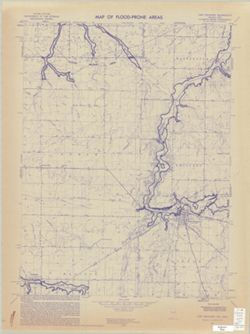
- Subject:
- Topical Subject: Floodplains, Topical Subject: Flood forecasting, Topical Subject: Floods, Geographic Subject: Darke County (Ohio), and Geographic Subject: R...
- Creator:
- Geological Survey (U.S.)
- Publisher:
- Geological Survey (U.S.)
- Date Created:
- 1974
- Identifier:
- VAC3073-M-00319
- Genre:
- Quadrangle maps, 7.5 minute topographic maps, and Topographic maps
- Geographic Location:
- Coordinates: W0845230 W0844500 N0401500 N0400730
- Related URL:
- Catalog URL: https://iucat.iu.edu/catalog/18416336
- Abstract:
- Filing title: Union City, Ind.-Ohio. Relief shown by contours and spot heights. Contour interval 10 feet. Includes quadrangle location map. Shows portions of...
- Call Number:
- G4091.C32 s24 .G4 Union City, Ind.-Ohio
- Caption:
- Imprint: Washington, D.C. : Interior--Geological Survey, [1974]
- Physical Description:
- Dimensions: 59 x 45 or smaller and Scale: 1:24,000
- Alternate Identifier:
- Alternate ID: CAW5372BB and Title Control Number: a18416336
- Persistent URL:
- https://purl.dlib.indiana.edu/iudl/images/VAC3073/VAC3073-M-00319
- Provenance:
- United States Department of the Interior, Geological Survey. Map of flood-prone areas : [Indiana]. Washington, D.C. : The Survey, 1969-.
-
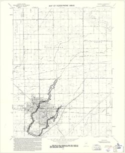
- Subject:
- Topical Subject: Floods, Geographic Subject: Miami County (Ind.), Geographic Subject: Grant County (Ind.), Topical Subject: Floodplains, Geographic Subject: ...
- Creator:
- Geological Survey (U.S.) and United States. Federal Insurance Administration
- Publisher:
- Geological Survey (U.S.)
- Date Created:
- 1974
- Identifier:
- VAC3073-M-00290
- Genre:
- Quadrangle maps, 7.5 minute topographic maps, and Topographic maps
- Geographic Location:
- Coordinates: W0855230 W0854500 N0403730 N0403000
- Related URL:
- Catalog URL: https://iucat.iu.edu/catalog/18416334
- Abstract:
- Filing title: Sweetser, Ind. Relief shown by contours and spot heights. Contour interval 10 feet. Includes quadrangle location map. Shows portion of Grant, M...
- Call Number:
- G4091.C32 s24 .G4 Sweetser, Ind. 1974
- Caption:
- Imprint: Washington, D.C. : Interior--Geological Survey, [1974]
- Physical Description:
- Dimensions: 59 x 45 or smaller and Scale: 1:24,000
- Alternate Identifier:
- Alternate ID: CAW5372BB and Title Control Number: a18416334
- Persistent URL:
- https://purl.dlib.indiana.edu/iudl/images/VAC3073/VAC3073-M-00290
- Provenance:
- United States Department of the Interior, Geological Survey. Map of flood-prone areas : [Indiana]. Washington, D.C. : The Survey, 1969-.
-
- Subject:
- Topical Subject: Flood forecasting, Topical Subject: Floodplains, Geographic Subject: Delaware County (Ind.), Topical Subject: Floods, Geographic Subject: Ma...
- Creator:
- United States. Federal Insurance Administration and Geological Survey (U.S.)
- Publisher:
- Geological Survey (U.S.)
- Date Created:
- 1970
- Identifier:
- VAC3073-M-00235
- Genre:
- Topographic maps, Quadrangle maps, and 7.5 minute topographic maps
- Geographic Location:
- Coordinates: W0855230 W0854500 N0403730 N0403000
- Related URL:
- Catalog URL: https://iucat.iu.edu/catalog/18416331
- Abstract:
- Filing title: Middletown, Ind. Relief shown by contours and spot heights. Contour interval 10 feet. Includes quadrangle location map. Shows portion of Henry,...
- Call Number:
- G4091.C32 s24 .G4 Middletown, Ind. 1970
- Caption:
- Imprint: Washington, D.C. : Interior--Geological Survey, [1970]
- Physical Description:
- Dimensions: 59 x 45 or smaller and Scale: 1:24,000
- Alternate Identifier:
- Title Control Number: a18416331 and Alternate ID: CAW5372BB
- Persistent URL:
- https://purl.dlib.indiana.edu/iudl/images/VAC3073/VAC3073-M-00235
- Provenance:
- Map of Flood-Prone Areas: Middletown Quadrangle, Indiana.
-
- Subject:
- Topical Subject: Flood forecasting, Geographic Subject: Knightstown Region (Ind.), Topical Subject: Floodplains, Geographic Subject: Henry County (Ind.), Geo...
- Creator:
- Geological Survey (U.S.)
- Publisher:
- Geological Survey (U.S.)
- Date Created:
- 1970
- Identifier:
- VAC3073-M-00888
- Genre:
- Topographic maps, 7.5 minute topographic maps, and Quadrangle maps
- Geographic Location:
- Coordinates: W0853730 W0853000 N0395230 N0394500
- Related URL:
- Catalog URL: https://iucat.iu.edu/catalog/18416327
- Abstract:
- Filing title: Knightstown, Ind. Relief shown by contours and spot heights. Contour interval 10 feet. Includes quadrangle location map. Shows portion of Henry...
- Call Number:
- G4091.C32 s24 .G4 Knightstown 1970
- Caption:
- Imprint: Washington, D.C. : Interior--Geological Survey, [1970]
- Physical Description:
- Scale: 1:24,000 and Dimensions: 59 x 45 or smaller
- Alternate Identifier:
- Alternate ID: CAW5372BB and Title Control Number: a18416327
- Persistent URL:
- https://purl.dlib.indiana.edu/iudl/images/VAC3073/VAC3073-M-00888
- Provenance:
- United States Department of the Interior, Geological Survey. Map of flood-prone areas : [Indiana]. Washington, D.C. : The Survey, 1969-.
-
- Subject:
- Geographic Subject: Hartford City Region (Ind.), Topical Subject: Floods, Geographic Subject: Blackford County (Ind.), Topical Subject: Flood forecasting, an...
- Creator:
- Geological Survey (U.S.)
- Publisher:
- Geological Survey (U.S.)
- Date Created:
- 1971
- Identifier:
- VAC3073-M-00895
- Genre:
- Topographic maps, Quadrangle maps, and 7.5 minute topographic maps
- Geographic Location:
- Coordinates: W0852230 W0851500 N0403000 N0402230
- Related URL:
- Catalog URL: https://iucat.iu.edu/catalog/18416323
- Abstract:
- Filing title: Hartford City East, Ind. Relief shown by contours and spot heights. Contour interval 10 feet. Includes quadrangle location map. Shows portion o...
- Call Number:
- G4091.C32 s24 .G4 Hartford City East, In
- Caption:
- Imprint: Washington, D.C. : Interior--Geological Survey, [1971]
- Physical Description:
- Dimensions: 59 x 45 or smaller and Scale: 1:24,000
- Alternate Identifier:
- Title Control Number: a18416323 and Alternate ID: CAW5372BB
- Persistent URL:
- https://purl.dlib.indiana.edu/iudl/images/VAC3073/VAC3073-M-00895
- Provenance:
- United States Department of the Interior, Geological Survey. Map of flood-prone areas : [Indiana]. Washington, D.C. : The Survey, 1969-.
-
- Subject:
- Topical Subject: Floodplains, Geographic Subject: Madison County (Ind.), Topical Subject: Floods, Topical Subject: Flood forecasting, and Geographic Subject:...
- Creator:
- United States. Federal Insurance Administration and Geological Survey (U.S.)
- Publisher:
- Geological Survey (U.S.)
- Date Created:
- 1973
- Identifier:
- VAC3073-M-00735
- Genre:
- Topographic maps, 7.5 minute topographic maps, and Quadrangle maps
- Geographic Location:
- Coordinates: W0853730 W0853000 N0401500 N0400730
- Related URL:
- Catalog URL: https://iucat.iu.edu/catalog/18416317
- Abstract:
- Filing title: Gilman, Ind. Relief shown by contours and spot heights. Contour interval 10 feet. Shows portions of Delaware and Madison counties, Indiana. Flo...
- Call Number:
- G4091.C32 s24 .G4 Gilman, Ind. 1973
- Caption:
- Imprint: Washington, D.C. : Interior--Geological Survey, [1973]
- Physical Description:
- Dimensions: 59 x 45 or smaller and Scale: 1:24,000
- Alternate Identifier:
- Title Control Number: a18416317 and Alternate ID: CAW5372BB
- Persistent URL:
- https://purl.dlib.indiana.edu/iudl/images/VAC3073/VAC3073-M-00735
- Provenance:
- United States Department of the Interior, Geological Survey. Map of flood-prone areas : [Indiana]. Washington, D.C. : The Survey, 1969-.
-
- Subject:
- Geographic Subject: Jay County (Ind.), Topical Subject: Flood forecasting, Topical Subject: Floods, Topical Subject: Floodplains, and Geographic Subject: Mer...
- Creator:
- United States. Federal Insurance Administration and Geological Survey (U.S.)
- Publisher:
- Geological Survey (U.S.)
- Date Created:
- 1973
- Identifier:
- VAC3073-M-00827
- Genre:
- Quadrangle maps, 7.5 minute topographic maps, and Topographic maps
- Geographic Location:
- Coordinates: W0845230 W0844500 N0403000 N0402230
- Related URL:
- Catalog URL: https://iucat.iu.edu/catalog/18416316
- Abstract:
- Filing title: Fort Recovery, Ind.-Ohio. Relief shown by contours and spot heights. Contour interval 10 feet. Includes quadrangle location map. Flood prone ar...
- Call Number:
- G4091.C32 s24 .G4 Fort Recovery 1973
- Caption:
- Imprint: Washington, D.C. : Interior--Geological Survey, [1973]
- Physical Description:
- Scale: 1:24,000 and Dimensions: 59 x 45 or smaller
- Alternate Identifier:
- Alternate ID: CAW5372BB and Title Control Number: a18416316
- Persistent URL:
- https://purl.dlib.indiana.edu/iudl/images/VAC3073/VAC3073-M-00827
- Provenance:
- United States Department of the Interior, Geological Survey. Map of flood-prone areas : [Indiana]. Washington, D.C. : The Survey, 1969-.
-
- Subject:
- Geographic Subject: Elwood (Ind.), Geographic Subject: Madison County (Ind.), Topical Subject: Flood forecasting, Geographic Subject: Tipton County (Ind.), T...
- Creator:
- Geological Survey (U.S.)
- Publisher:
- Geological Survey (U.S.)
- Date Created:
- 1970
- Identifier:
- VAC3073-M-00125
- Genre:
- 7.5 minute topographic maps, Quadrangle maps, and Topographic maps
- Geographic Location:
- Coordinates: W0855230 W0854500 N0402230 N0401500
- Related URL:
- Catalog URL: https://iucat.iu.edu/catalog/18416300
- Abstract:
- Filing title: Elwood, Ind. Relief shown by contours and spot heights. Contour interval 10 feet. Includes quadrangle location map. Flood prone areas and occas...
- Call Number:
- G4091.C32 s24 .G4 Elwood 1970
- Caption:
- Imprint: Washington, D.C. : Interior--Geological Survey, [1970]
- Physical Description:
- Scale: 1:24,000 and Dimensions: 59 x 45 or smaller
- Alternate Identifier:
- Title Control Number: a18416300 and Alternate ID: CAW5372BB
- Persistent URL:
- https://purl.dlib.indiana.edu/iudl/images/VAC3073/VAC3073-M-00125
- Provenance:
- United States Department of the Interior, Geological Survey. Map of flood-prone areas : [Indiana]. Washington, D.C. : The Survey, 1969-.
-
- Subject:
- Geographic Subject: Henry County (Ind.), Geographic Subject: Rush County (Ind.), Topical Subject: Floods, Topical Subject: Floodplains, and Topical Subject: ...
- Creator:
- Geological Survey (U.S.)
- Publisher:
- Geological Survey (U.S.)
- Date Created:
- 1970
- Identifier:
- VAC3073-M-00304
- Genre:
- Quadrangle maps, Topographic maps, and 7.5 minute topographic maps
- Geographic Location:
- Coordinates: W0853000 W0852230 N0395230 N0394500
- Related URL:
- Catalog URL: https://iucat.iu.edu/catalog/18416259
- Abstract:
- Filing title: Dunreith, Ind. Relief shown by contours and spot heights. Contour interval 10 feet. Includes quadrangle location map. Flood prone areas and occ...
- Call Number:
- G4091.C32 s24 .G4 Dunreith, Ind. 1970
- Caption:
- Imprint: [Washington, D.C.] : [Interior--Geological Survey], [1970]
- Physical Description:
- Scale: 1:24,000 and Dimensions: 59 x 45 or smaller
- Alternate Identifier:
- Title Control Number: a18416259 and Alternate ID: CAW5372BB
- Persistent URL:
- https://purl.dlib.indiana.edu/iudl/images/VAC3073/VAC3073-M-00304
- Provenance:
- United States Department of the Interior, Geological Survey. Map of flood-prone areas : [Indiana]. Washington, D.C. : The Survey, 1969-.
-
- Subject:
- Geographic Subject: Madison County (Ind.), Topical Subject: Floodplains, Geographic Subject: Anderson Region (Ind.), Topical Subject: Floods, and Topical Sub...
- Creator:
- Geological Survey (U.S.)
- Publisher:
- Geological Survey (U.S.)
- Date Created:
- 1973
- Identifier:
- VAC3073-M-01007
- Genre:
- Topographic maps, Quadrangle maps, and 7.5 minute topographic maps
- Geographic Location:
- Coordinates: W0854500 W0853730 N0400730 N0400000
- Related URL:
- Catalog URL: https://iucat.iu.edu/catalog/18416053
- Abstract:
- Filing title: Anderson South, Ind. Relief shown by contours and spot heights. Contour interval 10 feet. Includes quadrangle location map. Flood prone areas a...
- Call Number:
- G4091.C32 s24 .G4 Anderson South 1973
- Caption:
- Imprint: Washington, D.C. : Interior--Geological Survey, [1973]
- Physical Description:
- Scale: 1:24,000 and Dimensions: 59 x 45 or smaller
- Alternate Identifier:
- Title Control Number: a18416053 and Alternate ID: CAW5372BB
- Persistent URL:
- https://purl.dlib.indiana.edu/iudl/images/VAC3073/VAC3073-M-01007
- Provenance:
- United States Department of the Interior, Geological Survey. Map of flood-prone areas : [Indiana]. Washington, D.C. : The Survey, 1969-.
-
- Subject:
- Topical Subject: Flood forecasting, Geographic Subject: Madison County (Ind.), Topical Subject: Floods, Geographic Subject: Alexandria Region (Ind.), and Top...
- Creator:
- Geological Survey (U.S.)
- Publisher:
- Geological Survey (U.S.)
- Date Created:
- 1970
- Identifier:
- VAC3073-M-00162
- Genre:
- 7.5 minute topographic maps, Topographic maps, and Quadrangle maps
- Geographic Location:
- Coordinates: W0854500 W0853730 N0402230 N0401500
- Related URL:
- Catalog URL: https://iucat.iu.edu/catalog/18416051
- Abstract:
- Filing title: Alexandria, Ind. Relief shown by contours and spot heights. Contour interval 10 feet. Includes quadrangle location map. Flood prone areas and o...
- Call Number:
- G4091.C32 s24 .G4 Alexandria 1970
- Caption:
- Imprint: Washington, D.C. : Interior--Geological Survey, [1970]
- Physical Description:
- Scale: 1:24,000 and Dimensions: 59 x 45 or smaller
- Alternate Identifier:
- Alternate ID: CAW5372BB and Title Control Number: a18416051
- Persistent URL:
- https://purl.dlib.indiana.edu/iudl/images/VAC3073/VAC3073-M-00162
- Provenance:
- United States Department of the Interior, Geological Survey. Map of flood-prone areas : [Indiana]. Washington, D.C. : The Survey, 1969-.
-
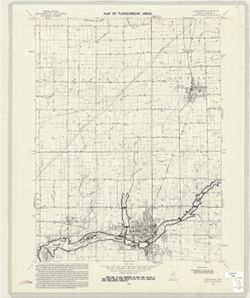
- Subject:
- Geographic Subject: Greencastle (Ind.), Topical Subject: Flood forecasting, Geographic Subject: Putnam County (Ind.), Topical Subject: Floodplains, and Topic...
- Creator:
- Geological Survey (U.S.)
- Publisher:
- Geological Survey (U.S.)
- Date Created:
- 1970
- Identifier:
- VAC3073-M-00867
- Genre:
- 7.5 minute topographic maps, Quadrangle maps, and Topographic maps
- Geographic Location:
- Coordinates: W0865230 W0864500 N0394500 N0393730
- Related URL:
- Catalog URL: https://iucat.iu.edu/catalog/18416317
- Abstract:
- Polyconic projection. Relief shown by contours and spot heights. 7.5 U.S. topographic map with flood-prone areas designated north and northeast of Greencastl...
- Call Number:
- G4091.C32 s24 .G4 Greencastle 1970
- Caption:
- Imprint: Washington, D.C. : United States, Department of the Interior, Geological Survey, 1970.
- Physical Description:
- Dimensions: 58 x 45 cm and Scale: 1:24,000
- Alternate Identifier:
- Title Control Number: a18416317 and Alternate ID: CAW5372BB
- Persistent URL:
- https://purl.dlib.indiana.edu/iudl/images/VAC3073/VAC3073-M-00867
- Provenance:
- United States Department of the Interior, Geological Survey. Map of flood-prone areas : [Indiana]. Washington, D.C. : The Survey, 1969-.
-
- Subject:
- Topical Subject: Counties, Geographic Subject: Indiana, and Topical Subject: Administrative and political divisions
- Creator:
- Geological Survey (U.S.)
- Publisher:
- Geological Survey (U.S.)
- Date Created:
- 1988
- Identifier:
- VAC3073-M-00025
- Genre:
- Maps
- Geographic Location:
- Coordinates: W0890000 W0840000 N0420000 N0373000
- Related URL:
- Catalog URL: https://iucat.iu.edu/catalog/18428209
- Abstract:
- At head of caption title: "Figure 1." Appears as Figure 1 in Indiana Gazetteer produced by the U.S.G.S. Professional Paper 1200-I. "The Nation...
- Call Number:
- QE75 .A4 No. 1200-IN
- Caption:
- Imprint: [Reston, Va.] : [The Survey], [1988]
- Physical Description:
- Dimensions: 29 cm or smaller and Scale: Approximately 1:3,200,000
- Alternate Identifier:
- Title Control Number: a18428209 and Alternate ID: 358171IP
- Persistent URL:
- https://purl.dlib.indiana.edu/iudl/images/VAC3073/VAC3073-M-00025
- Provenance:
- The National gazetteer of the United States of America--Indiana, 1988 / U.S. Geological Survey.
-
![Kosmosdale quadrangle, Kentucky-Indiana : 15 minute series (topographic) [1959 reprint with vegetation]](https://iiif.uits.iu.edu/iiif/2/mk61sm253%2Ffiles%2Fd8ce10eb-c8cf-4182-bd5a-13d2fee0e97a/full/250,/0/default.jpg)
- Subject:
- Geographic Subject: Floyd County (Ind.), Geographic Subject: Jefferson County (Ky.), Geographic Subject: Bullitt County (Ky.), Geographic Subject: Harrison C...
- Creator:
- United States. Army. Corps of Engineers and Geological Survey (U.S.)
- Publisher:
- Geological Survey (U.S.)
- Date Created:
- 1959
- Identifier:
- VAC3073-M-01348
- Genre:
- 15 minute topographic maps, Photogrammetric maps, Quadrangle maps, and Topographic maps
- Geographic Location:
- Coordinates: W0860000 W0854500 N0381500 N0380000
- Related URL:
- Catalog URL: https://iucat.iu.edu/catalog/18412709
- Abstract:
- Mapped by the Geological Survey and the Army Map Service , published for civil use by the Geological Survey. Filing title: Kosmodale, Ky.-Ind. Polyconic proj...
- Call Number:
- G4090 s62 .G4 Kosmosdale 1950 rep 1959 V
- Caption:
- Imprint: Washington, D.C. : Interior--Geological Survey, 1959
- Physical Description:
- Scale: 1:62,500 and Dimensions: 45 x 42 cm or smaller
- Alternate Identifier:
- Title Control Number: a18412709
- Persistent URL:
- https://purl.dlib.indiana.edu/iudl/images/VAC3073/VAC3073-M-01348
- Provenance:
- Part of Geological Survey (U.S.). Indiana 1:62,500.
-
![Kentucky-Indiana Uniontown quadrangle [1941 reprint without vegetation]](https://iiif.uits.iu.edu/iiif/2/rx914s94d%2Ffiles%2Fb75fcf05-19c0-4df9-9bed-49261c5f07c0/full/250,/0/default.jpg)
- Subject:
- Geographic Subject: Henderson County (Ky.), Geographic Subject: Posey County (Ind.), and Geographic Subject: Union County (Ky.)
- Creator:
- Gehres, W. S. (Wilmer Sherman), 1887-1963, Goodlove, C. W., U.S. Coast and Geodetic Survey, Ellis, J. R. (Topographer), Geological Survey (U.S.), Herrington,...
- Publisher:
- Geological Survey (U.S.)
- Date Created:
- 1941
- Identifier:
- VAC3073-M-01403
- Genre:
- Quadrangle maps, Topographic maps, and 15 minute topographic maps
- Geographic Location:
- Coordinates: W0880000 W0874500 N0380000 N0374500
- Related URL:
- Catalog URL: https://iucat.iu.edu/catalog/18415442
- Abstract:
- R.B. Marshall, chief geographer , W.H. Herron, geographer in charge , topography by C.W. Goodlove, R.M. Herrington and W.S. Gehres , control by U.S. Coast an...
- Call Number:
- G4090 s62 .G4 Uniontown 1917 rep1941
- Caption:
- Imprint: [Washington, D.C.] : U.S. Geological Survey, 1941
- Physical Description:
- Dimensions: 45 x 42 cm or smaller and Scale: 1:62,500
- Alternate Identifier:
- Title Control Number: a18415442
- Persistent URL:
- https://purl.dlib.indiana.edu/iudl/images/VAC3073/VAC3073-M-01403
- Provenance:
- Part of Geological Survey (U.S.). Indiana 1:62,500.
-
![Kentucky-Indiana Uniontown quadrangle [1941 reprint without vegetation]](https://iiif.uits.iu.edu/iiif/2/4m90fx89j%2Ffiles%2Fc2e137b5-4791-4eaa-a234-4e491cea321e/full/250,/0/default.jpg)
- Subject:
- Geographic Subject: Henderson County (Ky.), Geographic Subject: Posey County (Ind.), and Geographic Subject: Union County (Ky.)
- Creator:
- Kentucky Geological Survey, Marshall, R. B. (Robert Bradford), 1867-1949, Herrington, R. M. (Russell McKee), 1890-1977, U.S. Coast and Geodetic Survey, Hawki...
- Publisher:
- Geological Survey (U.S.)
- Date Created:
- 1941
- Identifier:
- VAC3073-M-01336
- Genre:
- Quadrangle maps, Topographic maps, and 15 minute topographic maps
- Geographic Location:
- Coordinates: W0880000 W0874500 N0380000 N0374500
- Related URL:
- Catalog URL: https://iucat.iu.edu/catalog/18415442
- Abstract:
- R.B. Marshall, chief geographer , W.H. Herron, geographer in charge , topography by C.W. Goodlove, R.M. Herrington and W.S. Gehres , control by U.S. Coast an...
- Call Number:
- G4090 s62 .G4 Uniontown 1917 rep 1941
- Caption:
- Imprint: [Washington, D.C.] : U.S. Geological Survey, 1941.
- Physical Description:
- Dimensions: 45 x 42 cm or smaller and Scale: 1:62,500
- Alternate Identifier:
- Title Control Number: a18415442
- Persistent URL:
- https://purl.dlib.indiana.edu/iudl/images/VAC3073/VAC3073-M-01336
- Provenance:
- Part of Geological Survey (U.S.). Indiana 1:62,500.
-
![Kentucky-Indiana Uniontown quadrangle [1929 without vegetation]](https://iiif.uits.iu.edu/iiif/2/bn99b9304%2Ffiles%2F7d8bdd0e-d8b8-4f23-b50f-402956e1a45a/full/250,/0/default.jpg)
- Subject:
- Geographic Subject: Posey County (Ind.), Geographic Subject: Union County (Ky.), and Geographic Subject: Henderson County (Ky.)
- Creator:
- Herrington, R. M. (Russell McKee), 1890-1977, Ellis, J. R. (Topographer), Geological Survey (U.S.), Herron, W. H. (William Harrison), 1865-, Hawkins, Geo. T....
- Publisher:
- Geological Survey (U.S.)
- Date Created:
- 1929
- Identifier:
- VAC3073-M-01335
- Genre:
- 15 minute topographic maps, Quadrangle maps, and Topographic maps
- Geographic Location:
- Coordinates: W0880000 W0874500 N0380000 N0374500
- Related URL:
- Catalog URL: https://iucat.iu.edu/catalog/18415442
- Abstract:
- R.B. Marshall, chief geographer , W.H. Herron, geographer in charge , topography by C.W. Goodlove, R.M. Herrington and W.S. Gehres , control by U.S. Coast an...
- Call Number:
- G4090 s62 .G4 1917 rep1929
- Caption:
- Imprint: [Washington, D.C.] : U.S. Geological Survey, 1929
- Physical Description:
- Dimensions: 45 x 42 cm or smaller and Scale: 1:62,500
- Alternate Identifier:
- Title Control Number: a18415442
- Persistent URL:
- https://purl.dlib.indiana.edu/iudl/images/VAC3073/VAC3073-M-01335
- Provenance:
- Part of Geological Survey (U.S.). Indiana 1:62,500.
-
![Kentucky-Indiana Uniontown quadrangle [1917 printing with vegetation]](https://iiif.uits.iu.edu/iiif/2/q811mp029%2Ffiles%2Fff48018f-d5c5-47dc-915f-7a5f1bfd279c/full/250,/0/default.jpg)
- Subject:
- Geographic Subject: Posey County (Ind.), Geographic Subject: Union County (Ky.), Geographic Subject: Henderson County (Ky.), and Topical Subject: Vegetation ...
- Creator:
- U.S. Coast and Geodetic Survey, Goodlove, C. W., Geological Survey (U.S.), Herron, W. H. (William Harrison), 1865-, Marshall, R. B. (Robert Bradford), 1867-1...
- Publisher:
- Geological Survey (U.S.)
- Date Created:
- 1917
- Identifier:
- VAC3073-M-01402
- Genre:
- Topographic maps, 15 minute topographic maps, and Quadrangle maps
- Geographic Location:
- Coordinates: W0880000 W0874500 N0380000 N0374500
- Related URL:
- Catalog URL: https://iucat.iu.edu/catalog/18415442
- Abstract:
- R.B. Marshall, chief geographer , W.H. Herron, geographer in charge , topography by C.W. Goodlove, R.M. Herrington and W.S. Gehres , control by U.S. Coast an...
- Call Number:
- G4090 s62 .G4 Uniontown 1917
- Caption:
- Imprint: [Washington, D.C.] : U.S. Geological Survey, [1917]
- Physical Description:
- Dimensions: 45 x 42 cm or smaller and Scale: 1:62,500
- Alternate Identifier:
- Title Control Number: a18415442
- Persistent URL:
- https://purl.dlib.indiana.edu/iudl/images/VAC3073/VAC3073-M-01402
- Provenance:
- Part of Geological Survey (U.S.). Indiana 1:62,500.
-
![Kentucky-Indiana Uniontown quadrangle [1917 printing with vegetation]](https://iiif.uits.iu.edu/iiif/2/rn302438g%2Ffiles%2F5ec44016-9965-4124-88f0-d69485cb679f/full/250,/0/default.jpg)
- Subject:
- Topical Subject: Vegetation mapping, Geographic Subject: Henderson County (Ky.), Geographic Subject: Posey County (Ind.), and Geographic Subject: Union Count...
- Creator:
- Kentucky Geological Survey, U.S. Coast and Geodetic Survey, Herron, W. H. (William Harrison), 1865-, United States. Army. Corps of Engineers, Hawkins, Geo. T...
- Publisher:
- Geological Survey (U.S.)
- Date Created:
- 1917
- Identifier:
- VAC3073-M-01334
- Genre:
- Quadrangle maps, Topographic maps, and 15 minute topographic maps
- Geographic Location:
- Coordinates: W0880000 W0874500 N0380000 N0374500
- Related URL:
- Catalog URL: https://iucat.iu.edu/catalog/18415442
- Abstract:
- R.B. Marshall, chief geographer , W.H. Herron, geographer in charge , topography by C.W. Goodlove, R.M. Herrington and W.S. Gehres , control by U.S. Coast an...
- Call Number:
- G4090 s62 .G4 Uniontown 1917
- Caption:
- Imprint: [Washington, D.C.] : U.S. Geological Survey, [1917]
- Physical Description:
- Scale: 1:62,500 and Dimensions: 45 x 42 cm or smaller
- Alternate Identifier:
- Title Control Number: a18415442
- Persistent URL:
- https://purl.dlib.indiana.edu/iudl/images/VAC3073/VAC3073-M-01334
- Provenance:
- Part of Geological Survey (U.S.). Indiana 1:62,500.
-
![Kentucky-Indiana Tell City quadrangle [1945 reprint]](https://iiif.uits.iu.edu/iiif/2/5q47ss70d%2Ffiles%2F88e1db91-03b0-4f7b-8e3b-12550bdda7a0/full/250,/0/default.jpg)
- Subject:
- Geographic Subject: Perry County (Ind.), Geographic Subject: Daviess County (Ky.), Geographic Subject: Spencer County (Ind.), and Geographic Subject: Hancock...
- Creator:
- Geological Survey (U.S.), Renshawe, John H., Cooke, Chas. E. (Charles E.), and Hawkins, Geo. T. (George T.)
- Publisher:
- Geological Survey (U.S.)
- Date Created:
- 1945
- Identifier:
- VAC3073-M-01394
- Genre:
- Topographic maps, 15 minute topographic maps, and Quadrangle maps
- Geographic Location:
- Coordinates: W0870000 W0864500 N0380000 N0374500
- Related URL:
- Catalog URL: https://iucat.iu.edu/catalog/18413981
- Abstract:
- John H. Renshawe, geographer in charge , control by George T. Hawkins , topography by Chas. E. Cooke. Filing title: Ky.-Ind. Tell City. Edition of 1903. Poly...
- Call Number:
- G4090 s62 .G4 Tell City 1903 rep1945
- Caption:
- Imprint: Washington, D.C. : U.S. Geological Survey, 1945
- Physical Description:
- Scale: 1:62,500 and Dimensions: 45 x 42 cm or smaller
- Alternate Identifier:
- Title Control Number: a18413981
- Persistent URL:
- https://purl.dlib.indiana.edu/iudl/images/VAC3073/VAC3073-M-01394
- Provenance:
- Part of Geological Survey (U.S.). Indiana 1:62,500.
-
![Kentucky-Indiana Prospect quadrangle [1941 reprint]](https://iiif.uits.iu.edu/iiif/2/n583zx80k%2Ffiles%2F0de7baa2-b556-4bc2-a198-4e9c9c77a358/full/250,/0/default.jpg)
- Subject:
- Geographic Subject: Oldham County (Ky.) and Geographic Subject: Jefferson County (Ky.)
- Creator:
- Smith, L. Scott, Ellis, J. R. (Topographer), Cooke, Chas. E. (Charles E.), Kentucky Geological Survey, Marshall, R. B. (Robert Bradford), 1867-1949, Herron, ...
- Publisher:
- Geological Survey (U.S.)
- Date Created:
- 1941
- Identifier:
- VAC3073-M-01389
- Genre:
- Topographic maps, Quadrangle maps, and 15 minute topographic maps
- Geographic Location:
- Coordinates: W0854500 W0853000 N0383000 N0381500
- Related URL:
- Catalog URL: https://iucat.iu.edu/catalog/18413939
- Abstract:
- R.B. Marshall, chief geographer , W.H. Herron, geographer in charge , topography by Chas. E. Cooke and L. Scott Smith , control by J.R. Ellis, C.H. Semper, a...
- Call Number:
- G4090 s62 .G4 Prospect 1912 rep1941
- Caption:
- Imprint: [Washington, D.C.] : U.S. Geological Survey, 1941
- Physical Description:
- Scale: 1:62,500 and Dimensions: 45 x 42 cm or smaller
- Alternate Identifier:
- Title Control Number: a18413939
- Persistent URL:
- https://purl.dlib.indiana.edu/iudl/images/VAC3073/VAC3073-M-01389
- Provenance:
- Part of Geological Survey (U.S.). Indiana 1:62,500.
-
![Kentucky-Indiana Newburg quadrangle [1944 reprint]](https://iiif.uits.iu.edu/iiif/2/2227ns88j%2Ffiles%2Ffa6f73de-96dc-4cea-88ae-5a429c8c2522/full/250,/0/default.jpg)
- Subject:
- Geographic Subject: Vanderburgh County (Ind.), Geographic Subject: Henderson County (Ky.), Geographic Subject: Warrick County (Ind.), Geographic Subject: Spe...
- Creator:
- Geological Survey (U.S.), Wilson, Herbert M. (Herbert Michael), 1860-1920, Lovell, W. H. (William H.), Renshawe, John H., and Goodlove, C. W.
- Publisher:
- Geological Survey (U.S.)
- Date Created:
- 1944
- Identifier:
- VAC3073-M-01362
- Genre:
- Quadrangle maps, 15 minute topographic maps, and Topographic maps
- Geographic Location:
- Coordinates: W0873000 W0871500 N0380000 N0374500
- Related URL:
- Catalog URL: https://iucat.iu.edu/catalog/18413843
- Abstract:
- H.M. Wilson and Jno. H. Renshawe, geographers in charge, topography by W.H. Lovell and Chas. W. Goodlove , control by Geo. T. Hawkins , engraved Mar. 1905 by...
- Call Number:
- G4090 s62 .G4 Newburg 1905 rep 1944
- Caption:
- Imprint: [Washington, D.C.] : U.S. Geological Survey, [1905]
- Physical Description:
- Scale: 1:62,500 and Dimensions: 45 x 42 cm or smaller
- Alternate Identifier:
- Title Control Number: a18413843
- Persistent URL:
- https://purl.dlib.indiana.edu/iudl/images/VAC3073/VAC3073-M-01362
- Provenance:
- Part of Geological Survey (U.S.). Indiana 1:62,500.
-
![Kentucky-Indiana Newburg quadrangle [1921 reprint]](https://iiif.uits.iu.edu/iiif/2/xd07hx325%2Ffiles%2F7f7773e3-968f-4af7-8c0f-2cfd86527969/full/250,/0/default.jpg)
- Subject:
- Geographic Subject: Warrick County (Ind.), Geographic Subject: Daviess County (Ind.), Geographic Subject: Henderson County (Ky.), Geographic Subject: Vanderb...
- Creator:
- Wilson, Herbert M. (Herbert Michael), 1860-1920, Renshawe, John H., Lovell, W. H. (William H.), Goodlove, C. W., and Geological Survey (U.S.)
- Publisher:
- Geological Survey (U.S.)
- Date Created:
- 1921
- Identifier:
- VAC3073-M-01361
- Genre:
- Topographic maps, Quadrangle maps, and 15 minute topographic maps
- Geographic Location:
- Coordinates: W0873000 W0871500 N0380000 N0374500
- Related URL:
- Catalog URL: https://iucat.iu.edu/catalog/18413843
- Abstract:
- H.M. Wilson and Jno. H. Renshawe, geographers in charge, topography by W.H. Lovell and Chas. W. Goodlove , control by Geo. T. Hawkins , engraved Mar. 1905 by...
- Call Number:
- G4090 s62 .G4 1905 rep 1921
- Caption:
- Imprint: [Washington, D.C.] : U.S. Geological Survey, 1921.
- Physical Description:
- Scale: 1:62,500 and Dimensions: 45 x 42 cm or smaller
- Alternate Identifier:
- Title Control Number: a18413843
- Persistent URL:
- https://purl.dlib.indiana.edu/iudl/images/VAC3073/VAC3073-M-01361
- Provenance:
- Part of Geological Survey (U.S.). Indiana 1:62,500.
-
![Kentucky-Indiana Kosmosdale quadrangle [1942 reprint]](https://iiif.uits.iu.edu/iiif/2/st74dt26w%2Ffiles%2F407269b9-644e-4f10-824a-6faa7578cf29/full/250,/0/default.jpg)
- Subject:
- Geographic Subject: Bullitt County (Ky.), Geographic Subject: Floyd County (Ind.), Geographic Subject: Jefferson County (Ind.), and Geographic Subject: Harri...
- Creator:
- Marshall, R. B. (Robert Bradford), 1867-1949, Graff, Fred, Jr., Clarkson, C. D. S., Geological Survey (U.S.), U.S. Coast and Geodetic Survey, Herron, W. H. (...
- Publisher:
- Geological Survey (U.S.)
- Date Created:
- 1942
- Identifier:
- VAC3073-M-01347
- Genre:
- Quadrangle maps, 15 minute topographic maps, and Topographic maps
- Geographic Location:
- Coordinates: W0860000 W0854500 N0381500 N0380000
- Related URL:
- Catalog URL: https://iucat.iu.edu/catalog/18413837
- Abstract:
- R.B. Marshall, chief geographer , W.H. Herron, geographer in charge , topography by C.D.S. Clarkson and Fred Graff, Jr., and the City of Louisville. Filing t...
- Call Number:
- G4090 s62 .G4 Kosmosdale 1912 rep 1942
- Caption:
- Imprint: Washington, D.C. : U.S. Geological Survey, 1942
- Physical Description:
- Dimensions: 45 x 42 cm or smaller and Scale: 1:62,500
- Alternate Identifier:
- Title Control Number: a18413837
- Persistent URL:
- https://purl.dlib.indiana.edu/iudl/images/VAC3073/VAC3073-M-01347
- Provenance:
- Part of Geological Survey (U.S.). Indiana 1:62,500.
-
![Kentucky-Indiana Henderson quadrangle [1947 reprint]](https://iiif.uits.iu.edu/iiif/2/8g84nq007%2Ffiles%2F1905d7bd-1124-4f85-864e-258fad082d25/full/250,/0/default.jpg)
- Subject:
- Geographic Subject: Hendricks County (Ind.), Geographic Subject: Posey County (Ind.), and Geographic Subject: Vanderburgh County (Ind.)
- Creator:
- Kentucky Geological Survey, United States. Army, Herrington, R. M. (Russell McKee), 1890-1977, Goodlove, C. W., Gehres, W. S. (Wilmer Sherman), 1887-1963, Ge...
- Publisher:
- Geological Survey (U.S.)
- Date Created:
- 1947
- Identifier:
- VAC3073-M-01344
- Genre:
- 15 minute topographic maps, Quadrangle maps, and Topographic maps
- Geographic Location:
- Coordinates: W0874500 W0873000 N0380000 N0374500
- Related URL:
- Catalog URL: https://iucat.iu.edu/catalog/18408409
- Abstract:
- Filing title: Henderson, Ky.-Ind. Edition of 1916. Relief shown by contours and spot heights. Shows Henderson and Vandergurgh counties in Kentucky and Posey ...
- Call Number:
- G4090 s62 .G4 1916 rep 1947
- Caption:
- Imprint: [Washington, D.C.] : Department of the Interior, U.S. Geological Survey, [1947]
- Physical Description:
- Dimensions: 45 x 42 cm or smaller and Scale: 1:62,500
- Alternate Identifier:
- Title Control Number: a18408409
- Persistent URL:
- https://purl.dlib.indiana.edu/iudl/images/VAC3073/VAC3073-M-01344
- Provenance:
- Part of Geological Survey (U.S.). Indiana 1:62,500.
-
![Kentucky-Indiana Henderson quadrangle [1916 printing]](https://iiif.uits.iu.edu/iiif/2/3t946v40d%2Ffiles%2F831c2385-8d1a-40d7-a1d6-fa14e229fd25/full/250,/0/default.jpg)
- Subject:
- Geographic Subject: Henderson County (Ky.), Geographic Subject: Posey County (Ind.), and Geographic Subject: Vanderburgh County (Ind.)
- Creator:
- U.S. Coast and Geodetic Survey, Herron, W. H. (William Harrison), 1865-, United States. Army, Gehres, W. S. (Wilmer Sherman), 1887-1963, Marshall, R. B. (Rob...
- Publisher:
- Geological Survey (U.S.)
- Date Created:
- 1916
- Identifier:
- VAC3073-M-01343
- Genre:
- Topographic maps, 15 minute topographic maps, and Quadrangle maps
- Geographic Location:
- Coordinates: W0874500 W0873000 N0380000 N0374500
- Related URL:
- Catalog URL: https://iucat.iu.edu/catalog/18408409
- Abstract:
- Filing title: Henderson, Ky.-Ind. Edition of 1916. Relief shown by contours and spot heights. Shows Henderson and Vandergurgh counties in Kentucky and Posey ...
- Call Number:
- G4090 s62 .G4 Henderson 1916
- Caption:
- Imprint: [Washington, D.C.] : Department of the Interior, U.S. Geological Survey, [1916]
- Physical Description:
- Dimensions: 45 x 42 cm or smaller and Scale: 1:62,500
- Alternate Identifier:
- Title Control Number: a18408409
- Persistent URL:
- https://purl.dlib.indiana.edu/iudl/images/VAC3073/VAC3073-M-01343
- Provenance:
- Part of Geological Survey (U.S.). Indiana 1:62,500.
-
![Kentucky-Indiana Cannelton quadrangle [1941 reprint]](https://iiif.uits.iu.edu/iiif/2/8336j442q%2Ffiles%2F47a90ccc-f6f3-4558-aeaf-5356b28b815d/full/250,/0/default.jpg)
- Subject:
- Geographic Subject: Breckinridge County (Ky.) and Geographic Subject: Hancock County (Ind.)
- Creator:
- United States. Army. Corps of Engineers, Tull, L. E. (Lawrence Emerson), 1894-1987, Higginson, W. S. (William Smith Muir), 1894-1984, and Runyan, R. H.
- Publisher:
- Geological Survey (U.S.)
- Date Created:
- 1941
- Identifier:
- VAC3073-M-01326
- Genre:
- Quadrangle maps, Topographic maps, and 15 minute topographic maps
- Geographic Location:
- Coordinates: W0864500 W0863000 N0380000 N0374500
- Related URL:
- Catalog URL: https://iucat.iu.edu/catalog/18415999
- Abstract:
- Topography by R.H. Runyan, W.S. Higginson, and L.E. Tull , Ohio River by Corps of Engineers, U.S. Army. Polyconic projection. Relief shown by contours and sp...
- Call Number:
- G4090 s62 .G4 Cannelton 1934 rep1941
- Caption:
- Imprint: Washington, D.C. : Dept. of the Interior, U.S. Geological Survey, 1941
- Physical Description:
- Dimensions: 45 x 42 cm or smaller and Scale: 1:62,500
- Alternate Identifier:
- Title Control Number: a18415999
- Persistent URL:
- https://purl.dlib.indiana.edu/iudl/images/VAC3073/VAC3073-M-01326
- Provenance:
- Part of Geological Survey (U.S.). Indiana 1:62,500.
-
![Indiana-Ohio, Winchester quadrangle [1918 printing]](https://iiif.uits.iu.edu/iiif/2/qv33t053b%2Ffiles%2F7be0c967-f78e-4d33-9858-3a9858958bdd/full/250,/0/default.jpg)
- Subject:
- Geographic Subject: Wayne County (Ind.), Geographic Subject: Randolph County (Ind.), and Geographic Subject: Darke County (Ohio)
- Creator:
- Geological Survey (U.S.), Harrison, R. L. (Topographer), Herron, W. H. (William Harrison), 1865-, Miller, W. L. (Topographer), Ellis, J. R. (Topographer), Sm...
- Publisher:
- Geological Survey (U.S.)
- Identifier:
- VAC3073-M-01414
- Genre:
- Topographic maps, Quadrangle maps, and 15 minute topographic maps
- Geographic Location:
- Coordinates: W0850000 W0844500 N0401500 N0400000
- Related URL:
- Catalog URL: https://iucat.iu.edu/catalog/18416004
- Abstract:
- W.H. Herron, acting chief geogrpher , Glenn S. Smith, topographic engineer in charge , topography by R.L. Harrison and W.L. Miller , control by J.R. Ellis, J...
- Call Number:
- G4090 s62 .G4 Winchester
- Caption:
- Imprint: [Washington, D.C.] : U.S. Geological Survey, [1918]
- Physical Description:
- Dimensions: 45 x 42 cm or smaller and Scale: 1:62,500
- Alternate Identifier:
- Title Control Number: a18416004
- Persistent URL:
- https://purl.dlib.indiana.edu/iudl/images/VAC3073/VAC3073-M-01414
- Provenance:
- Part of Geological Survey (U.S.). Indiana 1:62,500.
-
![Indiana-Ohio, Winchester quadrangle [1918 printing]](https://iiif.uits.iu.edu/iiif/2/xw42pc314%2Ffiles%2F87f0e842-bedb-4ab3-a0e6-270a4e9f7c9a/full/250,/0/default.jpg)
- Subject:
- Geographic Subject: Darke County (Ohio), Geographic Subject: Randolph County (Ind.), and Geographic Subject: Wayne County (Ind.)
- Creator:
- Smith, Glenn S. (Glenn Shepard), Herron, W. H. (William Harrison), 1865-, Geological Survey (U.S.), Ohio. Division of Geological Survey, Harrison, R. L. (Top...
- Publisher:
- Geological Survey (U.S.)
- Date Created:
- 1918
- Identifier:
- VAC3073-M-01310
- Genre:
- 15 minute topographic maps, Quadrangle maps, and Topographic maps
- Geographic Location:
- Coordinates: W0850000 W0844500 N0401500 N0400000
- Related URL:
- Catalog URL: https://iucat.iu.edu/catalog/18416004
- Abstract:
- W.H. Herron, acting chief geogrpher , Glenn S. Smith, topographic engineer in charge , topography by R.L. Harrison and W.L. Miller , control by J.R. Ellis, J...
- Call Number:
- G4090 s62 .G4 Winchester 1918
- Caption:
- Imprint: [Washington, D.C.] : U.S. Geological Survey, [1918]
- Physical Description:
- Scale: 1:62,500 and Dimensions: 45 x 42 cm or smaller
- Alternate Identifier:
- Title Control Number: a18416004
- Persistent URL:
- https://purl.dlib.indiana.edu/iudl/images/VAC3073/VAC3073-M-01310
- Provenance:
- Part of Geological Survey (U.S.). Indiana 1:62,500.
-
![Indiana-Ohio, Winchester Quadrangle [1958 reprint]](https://iiif.uits.iu.edu/iiif/2/6t054k339%2Ffiles%2F32b26c9a-d997-4a33-91af-06b933ded058/full/250,/0/default.jpg)
- Subject:
- Geographic Subject: Darke County (Ohio), Geographic Subject: Wayne County (Ind.), and Geographic Subject: Randolph County (Ind.)
- Creator:
- Smith, Glenn S. (Glenn Shepard), Miller, W. L. (Topographer), Geological Survey (U.S.), Ellis, J. R. (Topographer), Ohio. Division of Geological Survey, Harr...
- Publisher:
- Geological Survey (U.S.)
- Date Created:
- 1958
- Identifier:
- VAC3073-M-01415
- Genre:
- Topographic maps, Quadrangle maps, and 15 minute topographic maps
- Geographic Location:
- Coordinates: W0850000 W0844500 N0401500 N0400000
- Related URL:
- Catalog URL: https://iucat.iu.edu/catalog/18416004
- Abstract:
- W.H. Herron, acting chief geogrpher , Glenn S. Smith, topographic engineer in charge , topography by R.L. Harrison and W.L. Miller , control by J.R. Ellis, J...
- Call Number:
- G4090 s62 .G4 Winchester 1916 rep1958
- Caption:
- Imprint: [Washington, D.C.] : U.S. Geological Survey, 1958
- Physical Description:
- Scale: 1:62,500 and Dimensions: 45 x 42 cm or smaller
- Alternate Identifier:
- Title Control Number: a18416004
- Persistent URL:
- https://purl.dlib.indiana.edu/iudl/images/VAC3073/VAC3073-M-01415
- Provenance:
- Part of Geological Survey (U.S.). Indiana 1:62,500.
-
![Indiana-Kentucky Owensboro quadrangle [1950 reprint]](https://iiif.uits.iu.edu/iiif/2/dn39z555q%2Ffiles%2F89bb7d7d-8ace-46e8-8ef0-e69211350ab1/full/250,/0/default.jpg)
- Subject:
- Geographic Subject: Spencer County (Ind.), Geographic Subject: Warrick County (Ind.), and Geographic Subject: Daviess County (Ky.)
- Creator:
- Hawkins, Geo. T. (George T.), Renshawe, John H., Geological Survey (U.S.), and Cooke, Chas. E. (Charles E.)
- Publisher:
- Geological Survey (U.S.)
- Date Created:
- 1950
- Identifier:
- VAC3073-M-01376
- Genre:
- Quadrangle maps, 15 minute topographic maps, and Topographic maps
- Geographic Location:
- Coordinates: W0871500 W0870000 N0380000 N0374500
- Related URL:
- Catalog URL: https://iucat.iu.edu/catalog/18413576
- Abstract:
- John H. Renshaw, geographer in charge , control by George T. Hawkins , topography by Chas. E. Cooke. Filing title: Owensboro, Ind.-Ky. Edition of Nov. 1901. ...
- Call Number:
- G4090 s62 .G4 Owensboro 1901 rep 1950
- Caption:
- Imprint: Washington, D.C. : U.S. Geological Survey, 1950
- Physical Description:
- Scale: 1:62,500 and Dimensions: 45 x 42 cm or smaller
- Alternate Identifier:
- Title Control Number: a18413576
- Persistent URL:
- https://purl.dlib.indiana.edu/iudl/images/VAC3073/VAC3073-M-01376
- Provenance:
- Part of Geological Survey (U.S.). Indiana 1:62,500.
-
![Indiana-Kentucky Owensboro quadrangle [1939 reprint]](https://iiif.uits.iu.edu/iiif/2/vh53xz17f%2Ffiles%2F2a5358ca-9489-45f4-bdc4-1efa562d3cd9/full/250,/0/default.jpg)
- Subject:
- Geographic Subject: Spencer County (Ind.), Geographic Subject: Warrick County (Ind.), and Geographic Subject: Daviess County (Ky.)
- Creator:
- Renshawe, John H., Geological Survey (U.S.), Hawkins, Geo. T. (George T.), and Cooke, Chas. E. (Charles E.)
- Publisher:
- Geological Survey (U.S.)
- Date Created:
- 1939
- Identifier:
- VAC3073-M-01375
- Genre:
- Quadrangle maps, Topographic maps, and 15 minute topographic maps
- Geographic Location:
- Coordinates: W0871500 W0870000 N0380000 N0374500
- Related URL:
- Catalog URL: https://iucat.iu.edu/catalog/18413576
- Abstract:
- John H. Renshaw, geographer in charge , control by George T. Hawkins , topography by Chas. E. Cooke. Filing title: Owensboro, Ind.-Ky. Edition of Nov. 1901. ...
- Call Number:
- G4090 s62 .G4 Owensboro 1901 rep 1939
- Caption:
- Imprint: Washington, D.C. : U.S. Geological Survey, 1939
- Physical Description:
- Dimensions: 45 x 42 cm or smaller and Scale: 1:62,500
- Alternate Identifier:
- Title Control Number: a18413576
- Persistent URL:
- https://purl.dlib.indiana.edu/iudl/images/VAC3073/VAC3073-M-01375
- Provenance:
- Part of Geological Survey (U.S.). Indiana 1:62,500.
-
![Indiana-Kentucky Owensboro quadrangle [1925 reprint]](https://iiif.uits.iu.edu/iiif/2/nv936614b%2Ffiles%2F0065ee42-8514-4b9d-b077-6414175ea378/full/250,/0/default.jpg)
- Subject:
- Geographic Subject: Warrick County (Ind.), Geographic Subject: Daviess County (Ky.), and Geographic Subject: Spencer County (Ind.)
- Creator:
- Cooke, Chas. E. (Charles E.), Hawkins, Geo. T. (George T.), Renshawe, John H., and Geological Survey (U.S.)
- Publisher:
- Geological Survey (U.S.)
- Date Created:
- 1925
- Identifier:
- VAC3073-M-01374
- Genre:
- Topographic maps, Quadrangle maps, and 15 minute topographic maps
- Geographic Location:
- Coordinates: W0871500 W0870000 N0380000 N0374500
- Related URL:
- Catalog URL: https://iucat.iu.edu/catalog/18413576
- Abstract:
- John H. Renshaw, geographer in charge , control by George T. Hawkins , topography by Chas. E. Cooke. Filing title: Owensboro, Ind.-Ky. Edition of Nov. 1901. ...
- Call Number:
- G4090 s62 .G4 Owensboro 1901 rep 1925
- Caption:
- Imprint: Washington, D.C. : U.S. Geological Survey, 1925
- Physical Description:
- Dimensions: 45 x 42 cm or smaller and Scale: 1:62,500
- Alternate Identifier:
- Title Control Number: a18413576
- Persistent URL:
- https://purl.dlib.indiana.edu/iudl/images/VAC3073/VAC3073-M-01374
- Provenance:
- Part of Geological Survey (U.S.). Indiana 1:62,500.
-
![Indiana-Kentucky Owensboro quadrangle [1912 reprint]](https://iiif.uits.iu.edu/iiif/2/6d571071n%2Ffiles%2Fe60c13e2-5bbf-4e54-9481-ed8c9ad1c038/full/250,/0/default.jpg)
- Subject:
- Geographic Subject: Spencer County (Ind.), Geographic Subject: Daviess County (Ky.), and Geographic Subject: Warrick County (Ind.)
- Creator:
- Geological Survey (U.S.), Cooke, Chas. E. (Charles E.), Renshawe, John H., and Hawkins, Geo. T. (George T.)
- Publisher:
- Geological Survey (U.S.)
- Date Created:
- 1912
- Identifier:
- VAC3073-M-01373
- Genre:
- 15 minute topographic maps, Topographic maps, and Quadrangle maps
- Geographic Location:
- Coordinates: W0871500 W0870000 N0380000 N0374500
- Related URL:
- Catalog URL: https://iucat.iu.edu/catalog/18413576
- Abstract:
- John H. Renshaw, geographer in charge , control by George T. Hawkins , topography by Chas. E. Cooke. Filing title: Owensboro, Ind.-Ky. Edition of Nov. 1901. ...
- Call Number:
- G4090 s62 .G4 Owensboro 1901 rep 1912
- Caption:
- Imprint: Washington, D.C. : The Survey, 1912.
- Physical Description:
- Scale: 1:62,500 and Dimensions: 45 x 42 cm or smaller
- Alternate Identifier:
- Title Control Number: a18413576
- Persistent URL:
- https://purl.dlib.indiana.edu/iudl/images/VAC3073/VAC3073-M-01373
- Provenance:
- Part of Geological Survey (U.S.). Indiana 1:62,500.
-
![Indiana-Kentucky Corydon quadrangle [1931 printing]](https://iiif.uits.iu.edu/iiif/2/vq280r404%2Ffiles%2F2b715af8-dded-4de4-a4e3-8e1c86dcc800/full/250,/0/default.jpg)
- Subject:
- Geographic Subject: Meade County (Ky.)
- Creator:
- Kentucky Geological Survey, Higginson, W. S. (William Smith Muir), 1894-1984, United States. Army, and Geological Survey (U.S.)
- Publisher:
- Geological Survey (U.S.)
- Date Created:
- 1931
- Identifier:
- VAC3073-M-01321
- Genre:
- 15 minute topographic maps, Topographic maps, and Quadrangle maps
- Geographic Location:
- Coordinates: W0861500 W0860000 N0381500 N0380000
- Related URL:
- Catalog URL: https://iucat.iu.edu/catalog/18406398
- Abstract:
- Topography by W.S. Higginson , Ohio River by Corps of Engineers, U.S. Army , control by U.S. Geological Survey and Corps of Engineers, U.S. Army. Filing titl...
- Call Number:
- G4090 s62 .G4 Corydon 1931
- Caption:
- Imprint: [Washington, D.C.] : Dept. of the Interior, U.S. Geological Survey, [1931]
- Physical Description:
- Scale: 1:62,500 and Dimensions: 45 x 42 cm or smaller
- Alternate Identifier:
- Title Control Number: a18406398
- Persistent URL:
- https://purl.dlib.indiana.edu/iudl/images/VAC3073/VAC3073-M-01321
- Provenance:
- Part of Geological Survey (U.S.). Indiana 1:62,500.
-
![Indiana-Illinois, Vincennes quadrangle : topography [1958 reprint with vegetation]](https://iiif.uits.iu.edu/iiif/2/bv73d371v%2Ffiles%2Fd8eeacfe-4380-4ba5-814d-cbf9ec40a053/full/250,/0/default.jpg)
- Subject:
- Geographic Subject: Wabash County (Ill.), Topical Subject: Vegetation mapping, Geographic Subject: Lawrence County (Ill.), Geographic Subject: Gibson County ...
- Creator:
- Geological Survey (U.S.)
- Publisher:
- Geological Survey (U.S.)
- Date Created:
- 1958
- Identifier:
- VAC3073-M-01412
- Genre:
- Quadrangle maps, Topographic maps, and 15 minute topographic maps
- Geographic Location:
- Coordinates: W0874500 W0873000 N0384500 N0383000
- Related URL:
- Catalog URL: https://iucat.iu.edu/catalog/18415517
- Abstract:
- R.B. Marshall, chief geographer , W.H. Herron, geographer in charge , topography by Frank Tweedy, C.L. Sadler, Chas. Hartmann, Jr., L.L. Lee, W.S. Gehres, an...
- Call Number:
- G4090 s62 .G4 Vincennes 1944 rep1958 V
- Caption:
- Imprint: [Washington, D.C.] : U.S. Geological Survey, 1958
- Physical Description:
- Dimensions: 45 x 42 cm or smaller and Scale: 1:62,500
- Alternate Identifier:
- Title Control Number: a18415517
- Persistent URL:
- https://purl.dlib.indiana.edu/iudl/images/VAC3073/VAC3073-M-01412
- Provenance:
- Part of Geological Survey (U.S.). Indiana 1:62,500.
-
![Indiana-Illinois, Vincennes quadrangle : topography [1946 reprint with corrections and without vegetation]](https://iiif.uits.iu.edu/iiif/2/n009x521b%2Ffiles%2Fda21d6eb-ada6-4f1f-8c3c-8022f31eb1a9/full/250,/0/default.jpg)
- Subject:
- Geographic Subject: Lawrence County (Ill.), Geographic Subject: Knox County (Ind.), Geographic Subject: Gibson County (Ind.), and Geographic Subject: Wabash ...
- Creator:
- Geological Survey (U.S.), U.S. Coast and Geodetic Survey, Tweedy, Frank, 1854-1937, Illinois State Geological Survey, Marshall, R. B. (Robert Bradford), 1867...
- Publisher:
- Geological Survey (U.S.)
- Date Created:
- 1946
- Identifier:
- VAC3073-M-01410
- Genre:
- 15 minute topographic maps, Quadrangle maps, and Topographic maps
- Geographic Location:
- Coordinates: W0874500 W0873000 N0384500 N0383000
- Related URL:
- Catalog URL: https://iucat.iu.edu/catalog/18415510
- Abstract:
- R.B. Marshall, chief geographer , W.H. Herron, geographer in charge , topography by Frank Tweedy, C.L. Sadler, Chas. Hartmann, Jr., L.L. Lee, W.S. Gehres, an...
- Call Number:
- G4090 s62 .G4 Vincennes 1915 rep1946
- Caption:
- Imprint: [Washington, D.C.] : U.S. Geological Survey, 1946
- Physical Description:
- Scale: 1:62,500 and Dimensions: 45 x 42 cm or smaller
- Alternate Identifier:
- Title Control Number: a18415510
- Persistent URL:
- https://purl.dlib.indiana.edu/iudl/images/VAC3073/VAC3073-M-01410
- Provenance:
- Part of Geological Survey (U.S.). Indiana 1:62,500.
-
![Indiana-Illinois, Vincennes quadrangle : topography [1944 printing without vegetation]](https://iiif.uits.iu.edu/iiif/2/5425mf004%2Ffiles%2Fed25173c-f2ac-49e5-986c-99cf4220f9c3/full/250,/0/default.jpg)
- Subject:
- Geographic Subject: Gibson County (Ind.), Geographic Subject: Wabash County (Ill.), Geographic Subject: Lawrence County (Ill.), and Geographic Subject: Knox ...
- Creator:
- Marshall, R. B. (Robert Bradford), 1867-1949, Geological Survey (U.S.), Tweedy, Frank, 1854-1937, United States. Army. Corps of Engineers, Illinois State Geo...
- Publisher:
- Geological Survey (U.S.)
- Date Created:
- 1944
- Identifier:
- VAC3073-M-01508
- Genre:
- Topographic maps, 15 minute topographic maps, and Quadrangle maps
- Geographic Location:
- Coordinates: W0874500 W0873000 N0384500 N0383000
- Related URL:
- Catalog URL: https://iucat.iu.edu/catalog/18415517
- Abstract:
- R.B. Marshall, chief geographer , W.H. Herron, geographer in charge , topography by Frank Tweedy, C.L. Sadler, Chas. Hartmann, Jr., L.L. Lee, W.S. Gehres, an...
- Call Number:
- G4090 s62 .G4 Vincennes 1944
- Caption:
- Imprint: [Washington, D.C.] : U.S. Geological Survey, 1944.
- Physical Description:
- Scale: 1:62,500 and Dimensions: 45 x 42 cm or smaller
- Alternate Identifier:
- Title Control Number: a18415517
- Persistent URL:
- https://purl.dlib.indiana.edu/iudl/images/VAC3073/VAC3073-M-01508
- Provenance:
- Part of Geological Survey (U.S.). Indiana 1:62,500.
-
![Indiana-Illinois, New Harmony quadrangle [1942 reprint without vegetation]](https://iiif.uits.iu.edu/iiif/2/7m01cp450%2Ffiles%2F687ca4a9-29c4-4fc4-88d4-234e6f47aa32/full/250,/0/default.jpg)
- Subject:
- Geographic Subject: Gibson County (Ind.), Geographic Subject: Posey County (Ind.), Geographic Subject: Wabash County (Ill.), and Geographic Subject: White Co...
- Creator:
- Goodlove, C. W., Renshawe, John H., Hawkins, Geo. T. (George T.), and Geological Survey (U.S.)
- Publisher:
- Geological Survey (U.S.)
- Date Created:
- 1942
- Identifier:
- VAC3073-M-01355
- Genre:
- 15 minute topographic maps, Quadrangle maps, and Topographic maps
- Geographic Location:
- Coordinates: W0880000 W0874500 N0381500 N0380000
- Related URL:
- Catalog URL: https://iucat.iu.edu/catalog/18412806
- Abstract:
- John. H. Renshawe, geographer in charge , control by Geo. T. Hawkins , topography by Chas. W. Goodlove , engraved April 1903 by U.S.G.S. Filing title: New Ha...
- Call Number:
- G4090 s62 .G4 New Harmony 1903 rep 1942
- Caption:
- Imprint: [Washington, D.C.] : U.S. Geological Survey, 1942
- Physical Description:
- Scale: 1:62,500 and Dimensions: 45 x 42 cm or smaller
- Alternate Identifier:
- Title Control Number: a18412806
- Persistent URL:
- https://purl.dlib.indiana.edu/iudl/images/VAC3073/VAC3073-M-01355
- Provenance:
- Part of Geological Survey (U.S.). Indiana 1:62,500.
-
![Indiana-Illinois, New Harmony quadrangle [1925 reprint without vegetation]](https://iiif.uits.iu.edu/iiif/2/s4656k46j%2Ffiles%2F298a4b2a-341d-4dde-b5f8-f3216aba32b4/full/250,/0/default.jpg)
- Subject:
- Geographic Subject: White County (Ill.), Geographic Subject: Wabash County (Ill.), Geographic Subject: Posey County (Ind.), and Geographic Subject: Gibson Co...
- Creator:
- Renshawe, John H., Goodlove, C. W., Geological Survey (U.S.), and Hawkins, Geo. T. (George T.)
- Publisher:
- Geological Survey (U.S.)
- Date Created:
- 1925
- Identifier:
- VAC3073-M-01354
- Genre:
- Topographic maps, 15 minute topographic maps, and Quadrangle maps
- Geographic Location:
- Coordinates: W0880000 W0874500 N0381500 N0380000
- Related URL:
- Catalog URL: https://iucat.iu.edu/catalog/18412806
- Abstract:
- John. H. Renshawe, geographer in charge , control by Geo. T. Hawkins , topography by Chas. W. Goodlove , engraved April 1903 by U.S.G.S. Filing title: New Ha...
- Call Number:
- G4090 s62 .G4 1903 rep 1925
- Caption:
- Imprint: [Washington, D.C.] : U.S. Geological Survey, 1925
- Physical Description:
- Scale: 1:62,500 and Dimensions: 45 x 42 cm or smaller
- Alternate Identifier:
- Title Control Number: a18412806
- Persistent URL:
- https://purl.dlib.indiana.edu/iudl/images/VAC3073/VAC3073-M-01354
- Provenance:
- Part of Geological Survey (U.S.). Indiana 1:62,500.
-
![Indiana-Illinois Princeton quadrangle [1954 reprint without vegetation]](https://iiif.uits.iu.edu/iiif/2/jw828f49z%2Ffiles%2F930dff42-24ed-494d-8f59-03710825468a/full/250,/0/default.jpg)
- Subject:
- Geographic Subject: Knox County (Ind.), Geographic Subject: Gibson County (Ind.), and Geographic Subject: Wabash County (Ill.)
- Creator:
- Renshawe, John H., Goodlove, C. W., Geological Survey (U.S.), and Hawkins, Geo. T. (George T.)
- Publisher:
- Geological Survey (U.S.)
- Date Created:
- 1954
- Identifier:
- VAC3073-M-01382
- Genre:
- Quadrangle maps, 15 minute topographic maps, and Topographic maps
- Geographic Location:
- Coordinates: W0874500 W0873000 N0383000 N0381500
- Related URL:
- Catalog URL: https://iucat.iu.edu/catalog/18413586
- Abstract:
- Jno. H. Renshawe, geographer in charge , control by Geo. T. Hawkins , topography by Chas. W. Goodlove. Filing title: Princeton, Ind.-Ill. [Edition of] 1901, ...
- Call Number:
- G4090 s62 .G4 Princeton 1903 rep1954
- Caption:
- Imprint: Washington, D.C. : Interior--Geological Survey, 1954
- Physical Description:
- Scale: 1:62,500 and Dimensions: 45 x 42 cm or smaller
- Alternate Identifier:
- Title Control Number: a18413586
- Persistent URL:
- https://purl.dlib.indiana.edu/iudl/images/VAC3073/VAC3073-M-01382
- Provenance:
- Part of Geological Survey (U.S.). Indiana 1:62,500.
-
![Indiana-Illinois Princeton quadrangle [1949 printing with minor corrections]](https://iiif.uits.iu.edu/iiif/2/2801qk457%2Ffiles%2Fcc6a6a50-c066-4d88-b5e1-b12fb8789f26/full/250,/0/default.jpg)
- Subject:
- Geographic Subject: Gibson County (Ind.), Geographic Subject: Knox County (Ind.), and Geographic Subject: Wabash County (Ill.)
- Creator:
- Geological Survey (U.S.), Goodlove, C. W., Renshawe, John H., and Hawkins, Geo. T. (George T.)
- Publisher:
- Geological Survey (U.S.)
- Date Created:
- 1949
- Identifier:
- VAC3073-M-01381
- Genre:
- 15 minute topographic maps, Quadrangle maps, and Topographic maps
- Geographic Location:
- Coordinates: W0874500 W0873000 N0383000 N0381500
- Related URL:
- Catalog URL: https://iucat.iu.edu/catalog/18413586
- Abstract:
- Jno. H. Renshawe, geographer in charge , control by Geo. T. Hawkins , topography by Chas. W. Goodlove. Filing title: Princeton, Ind.-Ill. [Edition of] 1901, ...
- Call Number:
- G4090 s62 .G4 Princeton 1901 MC1949
- Caption:
- Imprint: Washington, D.C. : Interior--Geological Survey, 1949.
- Physical Description:
- Dimensions: 45 x 42 cm or smaller and Scale: 1:62,500
- Alternate Identifier:
- Title Control Number: a18413586
- Persistent URL:
- https://purl.dlib.indiana.edu/iudl/images/VAC3073/VAC3073-M-01381
- Provenance:
- Part of Geological Survey (U.S.). Indiana 1:62,500.
-
![Indiana-Illinois Princeton quadrangle [1942 reprint with corrections]](https://iiif.uits.iu.edu/iiif/2/5425md989%2Ffiles%2Fb50408af-597e-49b1-b839-d9b52b097540/full/250,/0/default.jpg)
- Subject:
- Geographic Subject: Gibson County (Ind.) and Geographic Subject: Knox County (Ind.)
- Creator:
- Geological Survey (U.S.), Goodlove, C. W., Renshawe, John H., and Hawkins, Geo. T. (George T.)
- Publisher:
- Geological Survey (U.S.)
- Date Created:
- 1942
- Identifier:
- VAC3073-M-01385
- Genre:
- Quadrangle maps, Topographic maps, and 15 minute topographic maps
- Geographic Location:
- Coordinates: W0874500 W0873000 N0383000 N0381500
- Related URL:
- Catalog URL: https://iucat.iu.edu/catalog/18413585
- Abstract:
- Jno. H. Renshawe, geographer in charge , control by Geo. T. Hawkins , topography by Chas. W. Goodlove. Filing title: Princeton, Ind.-Ill. Edition of 1903, re...
- Call Number:
- Part of Geological Survey (U.S.). Indiana 1:62,500.
- Caption:
- Imprint: [Washington, D.C.] : U.S. Geological Survey, 1942.
- Physical Description:
- Dimensions: 45 x 42 cm or smaller and Scale: 1:62,500
- Alternate Identifier:
- Title Control Number: a18413585
- Persistent URL:
- https://purl.dlib.indiana.edu/iudl/images/VAC3073/VAC3073-M-01385
- Provenance:
- Part of Geological Survey (U.S.). Indiana 1:62,500.
-
![Indiana-Illinois Princeton quadrangle [1942 print with corrections]](https://iiif.uits.iu.edu/iiif/2/9c67xs27g%2Ffiles%2F3b41e866-678d-4037-bcb6-7d00a8c69e5b/full/250,/0/default.jpg)
- Subject:
- Geographic Subject: Knox County (Ind.), Geographic Subject: Wabash County (Ill.), and Geographic Subject: Gibson County (Ind.)
- Creator:
- Geological Survey (U.S.), Goodlove, C. W., Hawkins, Geo. T. (George T.), and Renshawe, John H.
- Publisher:
- Geological Survey (U.S.)
- Date Created:
- 1942
- Identifier:
- VAC3073-M-01303
- Genre:
- Quadrangle maps, 15 minute topographic maps, and Topographic maps
- Geographic Location:
- Coordinates: W0874500 W0873000 N0383000 N0381500
- Related URL:
- Catalog URL: https://iucat.iu.edu/catalog/a18413584
- Abstract:
- Jno. H. Renshawe, geographer in charge , control by Geo. T. Hawkins , topography by Chas. W. Goodlove. Filing title: Princeton, Ind.-Ill. Edition of 1903, re...
- Call Number:
- G4090 s62 .G4 Princeton 1903 R1942
- Caption:
- Imprint: [Washington, D.C.] : U.S. Geological Survey, 1942
- Physical Description:
- Scale: 1:62,500 and Dimensions: 45 x 42 cm or smaller
- Alternate Identifier:
- Title Control Number: a18413585
- Persistent URL:
- https://purl.dlib.indiana.edu/iudl/images/VAC3073/VAC3073-M-01303
- Provenance:
- Part of Geological Survey (U.S.). Indiana 1:62,500.
-
![Indiana-Illinois Princeton quadrangle [1922 reprint without vegetation]](https://iiif.uits.iu.edu/iiif/2/6h441w77c%2Ffiles%2F986f1cc4-da3e-4f00-892e-f811ead944f8/full/250,/0/default.jpg)
- Subject:
- Geographic Subject: Gibson County (Ind.), Geographic Subject: Knox County (Ind.), and Geographic Subject: Wabash County (Ill.)
- Creator:
- Renshawe, John H., Hawkins, Geo. T. (George T.), Geological Survey (U.S.), and Goodlove, C. W.
- Publisher:
- Geological Survey (U.S.)
- Identifier:
- VAC3073-M-01302
- Genre:
- 15 minute topographic maps, Quadrangle maps, and Topographic maps
- Geographic Location:
- Coordinates: W0874500 W0873000 N0383000 N0381500
- Related URL:
- Catalog URL: https://iucat.iu.edu/catalog/a18413584
- Abstract:
- Jno. H. Renshawe, geographer in charge , control by Geo. T. Hawkins , topography by Chas. W. Goodlove. Filing title: Princeton, Ind.-Ill. Edition of 1903. Re...
- Call Number:
- G4090 s62 .G4 Princeton 1903 R1922
- Caption:
- Imprint: Washington, D.C. : U.S. Geological Survey, 1922
- Physical Description:
- Dimensions: 45 x 42 cm or smaller and Scale: 1:62,500
- Alternate Identifier:
- Title Control Number: a18413584
- Persistent URL:
- https://purl.dlib.indiana.edu/iudl/images/VAC3073/VAC3073-M-01302
- Provenance:
- Part of Geological Survey (U.S.). Indiana 1:62,500.
-
![Indiana-Illinois Princeton quadrangle [1922 reprint without vegetation]](https://iiif.uits.iu.edu/iiif/2/0r968719t%2Ffiles%2F75ec17c9-3877-4a76-8f1a-579970db193c/full/250,/0/default.jpg)
- Subject:
- Geographic Subject: Knox County (Ind.), Geographic Subject: Wabash County (Ill.), and Geographic Subject: Gibson County (Ind.)
- Creator:
- Goodlove, C. W., Geological Survey (U.S.), Renshawe, John H., and Hawkins, Geo. T. (George T.)
- Publisher:
- Geological Survey (U.S.)
- Date Created:
- 1922
- Identifier:
- VAC3073-M-01384
- Genre:
- 15 minute topographic maps, Topographic maps, and Quadrangle maps
- Geographic Location:
- Coordinates: W0874500 W0873000 N0383000 N0381500
- Related URL:
- Catalog URL: https://iucat.iu.edu/catalog/18413584
- Abstract:
- Jno. H. Renshawe, geographer in charge , control by Geo. T. Hawkins , topography by Chas. W. Goodlove. Filing title: Princeton, Ind.-Ill. Edition of 1903. Re...
- Call Number:
- G4090 s62 .G4 Princeton 1903 rep1922
- Caption:
- Imprint: Washington, D.C. : U.S. Geological Survey, 1922
- Physical Description:
- Scale: 1:62,500 and Dimensions: 45 x 42 cm or smaller
- Alternate Identifier:
- Title Control Number: a18413584
- Persistent URL:
- https://purl.dlib.indiana.edu/iudl/images/VAC3073/VAC3073-M-01384
- Provenance:
- Part of Geological Survey (U.S.). Indiana 1:62,500.
-
![Indiana-Illinois Princeton quadrangle [1918 reprint without vegetation]](https://iiif.uits.iu.edu/iiif/2/4j03f204d%2Ffiles%2Ff6858e73-7524-45b9-95f0-84b35f918de9/full/250,/0/default.jpg)
- Subject:
- Geographic Subject: Gibson County (Ind.), Geographic Subject: Knox County (Ind.), and Geographic Subject: Wabash County (Ill.)
- Creator:
- Goodlove, C. W., Hawkins, Geo. T. (George T.), Renshawe, John H., and Geological Survey (U.S.)
- Publisher:
- Geological Survey (U.S.)
- Date Created:
- 1918
- Identifier:
- VAC3073-M-01300
- Genre:
- Quadrangle maps, Topographic maps, and 15 minute topographic maps
- Geographic Location:
- Coordinates: W0874500 W0873000 N0383000 N0381500
- Related URL:
- Catalog URL: https://iucat.iu.edu/catalog/18413584
- Abstract:
- Jno. H. Renshawe, geographer in charge , control by Geo. T. Hawkins , topography by Chas. W. Goodlove. Filing title: Princeton, Ind.-Ill. Edition of 1903. Re...
- Call Number:
- G4090 s62 .G4 Princeton 1903 R1918
- Caption:
- Imprint: Washington, D.C. : U.S. Geological Survey, 1918
- Physical Description:
- Dimensions: 45 x 42 cm or smaller and Scale: 1:62,500
- Alternate Identifier:
- Title Control Number: a18413584
- Persistent URL:
- https://purl.dlib.indiana.edu/iudl/images/VAC3073/VAC3073-M-01300
- Provenance:
- Part of Geological Survey (U.S.). Indiana 1:62,500.
-
![Indiana-Illinois Princeton quadrangle [1918 reprint without vegetation]](https://iiif.uits.iu.edu/iiif/2/k356b654d%2Ffiles%2Fb7ecfd4f-f49f-4665-bea2-c519898beb43/full/250,/0/default.jpg)
- Subject:
- Geographic Subject: Gibson County (Ind.), Geographic Subject: Knox County (Ind.), and Geographic Subject: Wabash County (Ill.)
- Creator:
- Hawkins, Geo. T. (George T.), Geological Survey (U.S.), Renshawe, John H., and Goodlove, C. W.
- Publisher:
- Geological Survey (U.S.)
- Date Created:
- 1918
- Identifier:
- VAC3073-M-01383
- Genre:
- 15 minute topographic maps, Topographic maps, and Quadrangle maps
- Geographic Location:
- Coordinates: W0874500 W0873000 N0383000 N0381500
- Related URL:
- Catalog URL: https://iucat.iu.edu/catalog/18413584
- Abstract:
- Jno. H. Renshawe, geographer in charge , control by Geo. T. Hawkins , topography by Chas. W. Goodlove. Filing title: Princeton, Ind.-Ill. Edition of 1903. Re...
- Call Number:
- G4090 s62 .G4 Princeton 1903 rep1918
- Caption:
- Imprint: Washington, D.C. : U.S. Geological Survey, 1918.
- Physical Description:
- Dimensions: 45 x 42 cm or smaller and Scale: 1:62,500
- Alternate Identifier:
- Title Control Number: a18413584
- Persistent URL:
- https://purl.dlib.indiana.edu/iudl/images/VAC3073/VAC3073-M-01383
- Provenance:
- Part of Geological Survey (U.S.). Indiana 1:62,500.
-
![Indiana-Illinois Patoka quadrangle [1921 reprint]](https://iiif.uits.iu.edu/iiif/2/t435hg288%2Ffiles%2F74c3c556-9b7b-4cea-8524-77cc4573da67/full/250,/0/default.jpg)
- Subject:
- Geographic Subject: Posey County (Ind.), Geographic Subject: Gibson County (Ind.), Geographic Subject: White County (Ill.), Geographic Subject: Vanderburgh C...
- Creator:
- Hawkins, Geo. T. (George T.), Geological Survey (U.S.), Renshawe, John H., and Goodlove, C. W.
- Publisher:
- Geological Survey (U.S.)
- Date Created:
- 1921
- Identifier:
- VAC3073-M-01419
- Genre:
- 30 minute topographic maps, Topographic maps, and Quadrangle maps
- Geographic Location:
- Coordinates: W0880000 W0873000 N0383000 N0380000
- Related URL:
- Catalog URL: https://iucat.iu.edu/catalog/18416043
- Abstract:
- Jno. H. Renshawe, geographer in charge , control by Geo. T. Hawkins , topography by Chas. W. Goodlove , engraved June 1903 by U.S.G.S. Relief shown by contou...
- Call Number:
- G4090 s125 .G4 Patoka 1903 rep1921
- Caption:
- Imprint: [Washington, D.C.] : U.S. Geological Survey, 1921
- Physical Description:
- Dimensions: 45 x 36 cm and Scale: 1:125,000
- Alternate Identifier:
- Title Control Number: a18416043
- Persistent URL:
- https://purl.dlib.indiana.edu/iudl/images/VAC3073/VAC3073-M-01419
- Provenance:
- Part of Geological Survey (U.S.). Indiana 1:125,000.
-
![Indiana-Illinois Patoka quadrangle [1903 print]](https://iiif.uits.iu.edu/iiif/2/697004346%2Ffiles%2Fa8ce9ba2-6345-47f5-8aa5-e6adddaad8fd/full/250,/0/default.jpg)
- Subject:
- Geographic Subject: White County (Ill.), Geographic Subject: Edwards County (Ill.), Geographic Subject: Knox County (Ind.), Geographic Subject: Posey County ...
- Creator:
- Goodlove, C. W., Hawkins, Geo. T. (George T.), Geological Survey (U.S.), and Renshawe, John H.
- Publisher:
- Geological Survey (U.S.)
- Date Created:
- 1903
- Identifier:
- VAC3073-M-01418
- Genre:
- 30 minute topographic maps, Quadrangle maps, and Topographic maps
- Geographic Location:
- Coordinates: W0880000 W0873000 N0383000 N0380000
- Related URL:
- Catalog URL: https://iucat.iu.edu/catalog/18416043
- Abstract:
- Jno. H. Renshawe, geographer in charge , control by Geo. T. Hawkins , topography by Chas. W. Goodlove , engraved June 1903 by U.S.G.S. Relief shown by contou...
- Call Number:
- G4090 s125 .G4 Patoka 1903
- Caption:
- Imprint: [Washington, D.C.] : U.S. Geological Survey, [1903]
- Physical Description:
- Dimensions: 45 x 36 cm and Scale: 1:125,000
- Alternate Identifier:
- Title Control Number: a18416043
- Persistent URL:
- https://purl.dlib.indiana.edu/iudl/images/VAC3073/VAC3073-M-01418
- Provenance:
- Part of Geological Survey (U.S.). Indiana 1:125,000.
-
![Indiana, Ditney quadrangle [1936 reprint]](https://iiif.uits.iu.edu/iiif/2/6108wd72k%2Ffiles%2Fb445f2c6-cbee-44ef-907e-13b38773b333/full/250,/0/default.jpg)
- Subject:
- Geographic Subject: Vanderburgh County (Ind.), Geographic Subject: Pike County (Ind.), Geographic Subject: Warrick County (Ind.), Geographic Subject: Gibson ...
- Creator:
- Geological Survey (U.S.), Renshawe, John H., McKinney, R. C. (Robert C.), Blair, H. B. (Herbert Buxton), 1860-1905, and Goodlove, C. W.
- Publisher:
- Geological Survey (U.S.)
- Date Created:
- 1936
- Identifier:
- VAC3073-M-01417
- Genre:
- Quadrangle maps, Topographic maps, and 30 minute topographic maps
- Geographic Location:
- Coordinates: W0873000 W0870000 N0383000 N0380000
- Related URL:
- Catalog URL: https://iucat.iu.edu/catalog/18416043
- Abstract:
- Indiana, 30 minute series (topographic). Filing title: Ditney, Ind. Jno. H. Renshawe, geographer in charge , topography by H.B. Blair, R.C. McKinney, and Cha...
- Call Number:
- G4090 s125 .G4 Ditney 1902 rep1936
- Caption:
- Imprint: [United States] : Geological Survey, 1936
- Physical Description:
- Scale: 1:125,000 and Dimensions: 45 x 36 cm
- Alternate Identifier:
- Title Control Number: a18416043
- Persistent URL:
- https://purl.dlib.indiana.edu/iudl/images/VAC3073/VAC3073-M-01417
- Provenance:
- Part of Geological Survey (U.S.). Indiana 1:125,000.
-
![Indiana, Ditney quadrangle [1902 printing]](https://iiif.uits.iu.edu/iiif/2/pr76g7157%2Ffiles%2F6b2150ed-f127-4bd5-ab33-87b0e9707424/full/250,/0/default.jpg)
- Subject:
- Geographic Subject: Dubois County (Ind.), Geographic Subject: Warrick County (Ind.), Geographic Subject: Vanderburgh County (Ind.), Geographic Subject: Gibso...
- Creator:
- McKinney, R. C. (Robert C.), Geological Survey (U.S.), Blair, H. B. (Herbert Buxton), 1860-1905, Renshawe, John H., and Goodlove, C. W.
- Publisher:
- Geological Survey (U.S.)
- Date Created:
- 1902
- Identifier:
- VAC3073-M-01416
- Genre:
- Quadrangle maps, 30 minute topographic maps, and Topographic maps
- Geographic Location:
- Coordinates: W0873000 W0870000 N0383000 N0380000
- Related URL:
- Catalog URL: https://iucat.iu.edu/catalog/18416043
- Abstract:
- Indiana, 30 minute series (topographic). Filing title: Ditney, Ind. Jno. H. Renshawe, geographer in charge , topography by H.B. Blair, R.C. McKinney, and Cha...
- Call Number:
- G4090 s125 .G4 Ditney 1902
- Caption:
- Imprint: [United States] : Geological Survey, [1902]
- Physical Description:
- Dimensions: 45 x 36 cm and Scale: 1:125,000
- Alternate Identifier:
- Title Control Number: a18416043
- Persistent URL:
- https://purl.dlib.indiana.edu/iudl/images/VAC3073/VAC3073-M-01416
- Provenance:
- Part of Geological Survey (U.S.). Indiana 1:125,000.
-
![Indiana, 15 minute series (topographic), Vincennes quadrangle. [1934 reprint without vegetation]](https://iiif.uits.iu.edu/iiif/2/h702rb42n%2Ffiles%2Ff1e13118-9dbf-4ee1-a0ac-56cd2eb3a880/full/250,/0/default.jpg)
- Subject:
- Geographic Subject: Gibson County (Ind.), Geographic Subject: Knox County (Ind.), Geographic Subject: Lawrence County (Ill.), and Geographic Subject: Wabash ...
- Creator:
- Tweedy, Frank, 1854-1937, U.S. Coast and Geodetic Survey, Herron, W. H. (William Harrison), 1865-, United States. Army. Corps of Engineers, Geological Survey...
- Publisher:
- Geological Survey (U.S.)
- Date Created:
- 1934
- Identifier:
- VAC3073-M-01409
- Genre:
- Topographic maps, Quadrangle maps, and 15 minute topographic maps
- Geographic Location:
- Coordinates: W0874500 W0873000 N0384500 N0383000
- Related URL:
- Catalog URL: https://iucat.iu.edu/catalog/18415508
- Abstract:
- R.B. Marshall, chief geographer , W.H. Herron, geographer in charge , topography by Frank Tweedy, C.L. Sadler, Chas. Hartmann, Jr., L.L. Lee, W.S. Gehres, an...
- Call Number:
- G4090 s62 .G4 Vincennes 1915 rep1934
- Caption:
- Imprint: [Washington, D.C.] : U.S. Geological Survey, 1934
- Physical Description:
- Scale: 1:62,500 and Dimensions: 45 x 42 cm or smaller
- Alternate Identifier:
- Title Control Number: a18415508
- Persistent URL:
- https://purl.dlib.indiana.edu/iudl/images/VAC3073/VAC3073-M-01409
- Provenance:
- Part of Geological Survey (U.S.). Indiana 1:62,500.
-
![Indiana, 15 minute series (topographic), Vincennes quadrangle. [1915 printing with vegetation]](https://iiif.uits.iu.edu/iiif/2/d791tm29s%2Ffiles%2F3ba9ccbe-8be1-48ce-9aac-c0c3b1eb0e6b/full/250,/0/default.jpg)
- Subject:
- Geographic Subject: Lawrence County (Ill.), Topical Subject: Vegetation mapping, Geographic Subject: Knox County (Ind.), Geographic Subject: Gibson County (I...
- Creator:
- Tweedy, Frank, 1854-1937, Geological Survey (U.S.), Marshall, R. B. (Robert Bradford), 1867-1949, United States. Army. Corps of Engineers, Herron, W. H. (Wil...
- Publisher:
- Geological Survey (U.S.)
- Date Created:
- 1915
- Identifier:
- VAC3073-M-01411
- Genre:
- 15 minute topographic maps, Topographic maps, and Quadrangle maps
- Geographic Location:
- Coordinates: W0874500 W0873000 N0384500 N0383000
- Related URL:
- Catalog URL: https://iucat.iu.edu/catalog/18415508
- Abstract:
- R.B. Marshall, chief geographer , W.H. Herron, geographer in charge , topography by Frank Tweedy, C.L. Sadler, Chas. Hartmann, Jr., L.L. Lee, W.S. Gehres, an...
- Call Number:
- G4090 s62 .G4 Vincennes 1915
- Caption:
- Imprint: [Washington, D.C.] : U.S. Geological Survey, [1915]
- Physical Description:
- Dimensions: 45 x 42 cm or smaller and Scale: 1:62,500
- Alternate Identifier:
- Title Control Number: a18415508
- Persistent URL:
- https://purl.dlib.indiana.edu/iudl/images/VAC3073/VAC3073-M-01411
- Provenance:
- Part of Geological Survey (U.S.). Indiana 1:62,500.
-
![Indiana, 15 minute series (topographic), New Haven quadrangle [1958 printing with vegetation]](https://iiif.uits.iu.edu/iiif/2/2514pp79t%2Ffiles%2F0d5ff364-2218-4a66-8b60-6f38aa96fe7f/full/250,/0/default.jpg)
- Subject:
- Topical Subject: Vegetation mapping, Geographic Subject: Posey County (Ind.), Geographic Subject: Gallatin County (Ill.), Geographic Subject: White County (I...
- Creator:
- Geological Survey (U.S.)
- Publisher:
- Geological Survey (U.S.)
- Date Created:
- 1958
- Identifier:
- VAC3073-M-01360
- Genre:
- Topographic maps, 15 minute topographic maps, and Quadrangle maps
- Geographic Location:
- Coordinates: W0881500 W0880000 N0380000 N0374500
- Related URL:
- Catalog URL: https://iucat.iu.edu/catalog/18413861
- Abstract:
- United States, Department of the Interior, Geological Survey , State of Illinois, Department of Registration and Education, Geological Survey Division , Stat...
- Call Number:
- G4090 s62 .G4 New Haven 1949 rep 1958 V
- Caption:
- Imprint: Washington, D.C. : Interior--Geological Survey, 1958
- Physical Description:
- Scale: 1:62,500 and Dimensions: 45 x 42 cm or smaller
- Alternate Identifier:
- Title Control Number: a18413861
- Persistent URL:
- https://purl.dlib.indiana.edu/iudl/images/VAC3073/VAC3073-M-01360
- Provenance:
- Part of Geological Survey (U.S.). Indiana 1:62,500.
-
- Subject:
- Geographic Subject: Birds (Ind.)
- Publisher:
- Geological Survey (U.S.)
- Date Created:
- 1917
- Identifier:
- VAC3073-M-01318
- Genre:
- Topographic maps and 15 minute topographic maps
- Related URL:
- Catalog URL: new.iucat.iu.edu/catalog/2863930
- Call Number:
- G4090 s62 .G4 Birds 1917
- Caption:
- Imprint: Washington, D.C. : The Survey, 1917.
- Physical Description:
- Scale: 1:62,500 and Dimensions: maps : col., 45 x 42 cm., or smaller.
- Persistent URL:
- https://purl.dlib.indiana.edu/iudl/images/VAC3073/VAC3073-M-01318
-
![Indiana Velpen quadrangle [1936 reprint]](https://iiif.uits.iu.edu/iiif/2/z316r503r%2Ffiles%2Fff5fa112-3598-4f96-a57d-5bd5fcb23db6/full/250,/0/default.jpg)
- Subject:
- Geographic Subject: Pike County (Ind.) and Geographic Subject: Dubois County (Ind.)
- Creator:
- Goodlove, C. W., Hawkins, Geo. T. (George T.), and Geological Survey (U.S.)
- Publisher:
- Geological Survey (U.S.)
- Date Created:
- 1936
- Identifier:
- VAC3073-M-01408
- Genre:
- 15 minute topographic maps, Quadrangle maps, and Topographic maps
- Geographic Location:
- Coordinates: W0871500 W0870000 N0383000 N0381500
- Related URL:
- Catalog URL: https://iucat.iu.edu/catalog/18415495
- Abstract:
- Jno. H. Renshawe, geographer in charge , control by Geo. T. Hawkins , topography by Chas. W. Goodlove , engraved Oct. 1902 by U.S.G.S. Polyconic projectio...
- Call Number:
- G4093.P4C5 1900 .G4
- Caption:
- Imprint: Washington, D.C. : U.S. Geological Survey, [1903]
- Physical Description:
- Dimensions: 45 x 42 cm or smaller and Scale: 1:62,500
- Alternate Identifier:
- Title Control Number: a18415495
- Persistent URL:
- https://purl.dlib.indiana.edu/iudl/images/VAC3073/VAC3073-M-01408
- Provenance:
- Part of Geological Survey (U.S.). Indiana 1:62,500.
-
![Indiana Velpen quadrangle [1903 printing]](https://iiif.uits.iu.edu/iiif/2/70796d46b%2Ffiles%2F57edc4e0-ddd1-4ff6-ab07-25dd93b93b50/full/250,/0/default.jpg)
- Subject:
- Geographic Subject: Dubois County (Ind.) and Geographic Subject: Pike County (Ind.)
- Creator:
- Geological Survey (U.S.), Renshawe, John H., Goodlove, C. W., and Hawkins, Geo. T. (George T.)
- Publisher:
- Geological Survey (U.S.)
- Date Created:
- 1903
- Identifier:
- VAC3073-M-01309
- Genre:
- 15 minute topographic maps, Quadrangle maps, and Topographic maps
- Geographic Location:
- Coordinates: W0871500 W0870000 N0383000 N0381500
- Related URL:
- Catalog URL: https://iucat.iu.edu/catalog/18415495
- Abstract:
- Jno. H. Renshawe, geographer in charge , control by Geo. T. Hawkins , topography by Chas. W. Goodlove , engraved Oct. 1902 by U.S.G.S. Edition of Feb. 1903. ...
- Call Number:
- G4090 s62 .G4 Velpen 1903
- Caption:
- Imprint: Washington, D.C. : U.S. Geological Survey, [1903]
- Physical Description:
- Scale: 1:62,500 and Dimensions: 45 x 42 cm or smaller
- Alternate Identifier:
- Title Control Number: a18415495
- Persistent URL:
- https://purl.dlib.indiana.edu/iudl/images/VAC3073/VAC3073-M-01309
- Provenance:
- Part of Geological Survey (U.S.). Indiana 1:62,500.
-
![Indiana St. Meinrad quadrangle [1936 reprint]](https://iiif.uits.iu.edu/iiif/2/db78vg83w%2Ffiles%2Faed1f382-144b-48a5-81c6-0511f0a3ccf0/full/250,/0/default.jpg)
- Subject:
- Geographic Subject: Spencer County (Ind.), Geographic Subject: Dubois County (Ind.), and Geographic Subject: Perry County (Ind.)
- Creator:
- Goodlove, C. W., Renshawe, John H., Hawkins, Geo. T. (George T.), and Geological Survey (U.S.)
- Publisher:
- Geological Survey (U.S.)
- Date Created:
- 1936
- Identifier:
- VAC3073-M-01393
- Genre:
- Quadrangle maps, 15 minute topographic maps, and Topographic maps
- Geographic Location:
- Coordinates: W0870000 W0864500 N0381500 N0380000
- Related URL:
- Catalog URL: https://iucat.iu.edu/catalog/18413973
- Abstract:
- Jno. H. Renshawe, geographer in charge , control by Geo. T. Hawkins , topography by Chas. W. Goodlove , engraved Jan. 1903 by U.S.G.S. Edition of 1903. Poly...
- Call Number:
- G4090 s62 .G4 St. Meinrad 1903 rep1936
- Caption:
- Imprint: Washington, D.C. : U.S. Geological Survey, 1936
- Physical Description:
- Scale: 1:62,500 and Dimensions: 45 x 42 cm or smaller
- Alternate Identifier:
- Title Control Number: a18413973
- Persistent URL:
- https://purl.dlib.indiana.edu/iudl/images/VAC3073/VAC3073-M-01393
- Provenance:
- Part of Geological Survey (U.S.). Indiana 1:62,500.
-
![Indiana St. Meinrad quadrangle [1903 printing]](https://iiif.uits.iu.edu/iiif/2/nk323h76c%2Ffiles%2Fe917d3f1-9cbd-4705-9a9a-2617f0dbde44/full/250,/0/default.jpg)
- Subject:
- Geographic Subject: Perry County (Ind.), Geographic Subject: Dubois County (Ind.), and Geographic Subject: Spencer County (Ind.)
- Creator:
- Goodlove, C. W., Renshawe, John H., Hawkins, Geo. T. (George T.), and Geological Survey (U.S.)
- Publisher:
- Geological Survey (U.S.)
- Date Created:
- 1903
- Identifier:
- VAC3073-M-01392
- Genre:
- Quadrangle maps, Topographic maps, and 15 minute topographic maps
- Geographic Location:
- Coordinates: W0870000 W0864500 N0381500 N0380000
- Related URL:
- Catalog URL: https://iucat.iu.edu/catalog/18413973
- Abstract:
- Jno. H. Renshawe, geographer in charge , control by Geo. T. Hawkins , topography by Chas. W. Goodlove , engraved Jan. 1903 by U.S.G.S. Edition of 1903. Poly...
- Call Number:
- G4090 s62 .G4 St. Meinrad 1903
- Caption:
- Imprint: Washington, D.C. : U.S. Geological Survey, 1903
- Physical Description:
- Dimensions: 45 x 42 cm or smaller and Scale: 1:62,500
- Alternate Identifier:
- Title Control Number: a18413973
- Persistent URL:
- https://purl.dlib.indiana.edu/iudl/images/VAC3073/VAC3073-M-01392
- Provenance:
- Part of Geological Survey (U.S.). Indiana 1:62,500.
-
![Indiana St. Meinrad quadrangle [1903 printing]](https://iiif.uits.iu.edu/iiif/2/9s1629486%2Ffiles%2Fc57731db-f713-427e-8c16-3f38d7e6a078/full/250,/0/default.jpg)
- Subject:
- Geographic Subject: Dubois County (Ind.), Geographic Subject: Spencer County (Ind.), and Geographic Subject: Perry County (Ind.)
- Creator:
- Goodlove, C. W., Renshawe, John H., Geological Survey (U.S.), and Hawkins, Geo. T. (George T.)
- Publisher:
- Geological Survey (U.S.)
- Date Created:
- 1903
- Identifier:
- VAC3073-M-01305
- Genre:
- Quadrangle maps, 15 minute topographic maps, and Topographic maps
- Geographic Location:
- Coordinates: W0870000 W0864500 N0381500 N0380000
- Related URL:
- Catalog URL: https://iucat.iu.edu/catalog/18413973
- Abstract:
- Jno. H. Renshawe, geographer in charge , control by Geo. T. Hawkins , topography by Chas. W. Goodlove , engraved Jan. 1903 by U.S.G.S. Edition of 1903. Poly...
- Call Number:
- G4090 s62 .G4 St. Meinrad 1903
- Caption:
- Imprint: Washington, D.C. : U.S. Geological Survey, 1903
- Physical Description:
- Dimensions: 45 x 42 cm or smaller and Scale: 1:62,500
- Alternate Identifier:
- Title Control Number: a18413973
- Persistent URL:
- https://purl.dlib.indiana.edu/iudl/images/VAC3073/VAC3073-M-01305
- Provenance:
- Part of Geological Survey (U.S.). Indiana 1:62,500.
-
![Indiana Porter quadrangle [1950 reprint]](https://iiif.uits.iu.edu/iiif/2/v692v944q%2Ffiles%2Fb084bc69-a329-42a5-a2f8-741c2958c149/full/250,/0/default.jpg)
- Subject:
- Geographic Subject: Lake County (Ind.) and Geographic Subject: Porter County (Ind.)
- Creator:
- Geological Survey (U.S.) and Clement, S. E. (Stephen Earl), 1894-1981
- Publisher:
- Geological Survey (U.S.)
- Date Created:
- 1950
- Identifier:
- VAC3073-M-01380
- Genre:
- Quadrangle maps, 15 minute topographic maps, and Topographic maps
- Geographic Location:
- Coordinates: W0871500 W0870000 N0414500 N0413000
- Related URL:
- Catalog URL: https://iucat.iu.edu/catalog/18416370
- Abstract:
- Filing title: Porter, Ind. Edition of 1940. Polyconic projection. Relief shown by contours and spot heights. Contour interval 10 feet. Surveyed in 1934. Repr...
- Call Number:
- G4090 s62 .G4 Porter 1940 rep 1950
- Caption:
- Imprint: Washington, D.C. : U.S. Dept. of the Interior, Geological Survey, 1950
- Physical Description:
- Dimensions: 45 x 42 cm or smaller and Scale: 1:62,500
- Alternate Identifier:
- Title Control Number: a18416370
- Persistent URL:
- https://purl.dlib.indiana.edu/iudl/images/VAC3073/VAC3073-M-01380
- Provenance:
- Part of Geological Survey (U.S.). Indiana 1:62,500.
-
![Indiana Porter quadrangle [1940 printing]](https://iiif.uits.iu.edu/iiif/2/qb98nk032%2Ffiles%2F56b05fe7-af3d-4253-a42a-a53971fe7601/full/250,/0/default.jpg)
- Subject:
- Geographic Subject: Porter County (Ind.) and Geographic Subject: Lake County (Ind.)
- Creator:
- Clement, S. E. (Stephen Earl), 1894-1981 and Geological Survey (U.S.)
- Publisher:
- Geological Survey (U.S.)
- Date Created:
- 1940
- Identifier:
- VAC3073-M-01299
- Genre:
- 15 minute topographic maps, Quadrangle maps, and Topographic maps
- Geographic Location:
- Coordinates: W0871500 W0870000 N0414500 N0413000
- Related URL:
- Catalog URL: https://iucat.iu.edu/catalog/18416370
- Abstract:
- Filing title: Porter, Ind. Edition of 1940. Polyconic projection. Relief shown by contours and spot heights. Contour interval 10 feet. Surveyed in 1934. Repr...
- Call Number:
- G4090 s62 .G4 Porter 1940
- Caption:
- Imprint: Washington, D.C. : U.S. Dept. of the Interior, Geological Survey, 1940
- Physical Description:
- Scale: 1:62,500 and Dimensions: 45 x 42 cm or smaller
- Alternate Identifier:
- Title Control Number: a18416370
- Persistent URL:
- https://purl.dlib.indiana.edu/iudl/images/VAC3073/VAC3073-M-01299
- Provenance:
- Part of Geological Survey (U.S.). Indiana 1:62,500.
-
![Indiana Porter quadrangle [1940 printing]](https://iiif.uits.iu.edu/iiif/2/000013119%2Ffiles%2F0b2153bf-bc62-414d-8775-578073b39f68/full/250,/0/default.jpg)
- Subject:
- Geographic Subject: Lake County (Ind.) and Geographic Subject: Porter County (Ind.)
- Creator:
- Geological Survey (U.S.) and Clement, S. E. (Stephen Earl), 1894-1981
- Publisher:
- Geological Survey (U.S.)
- Date Created:
- 1940
- Identifier:
- VAC3073-M-01379
- Genre:
- Topographic maps, Quadrangle maps, and 15 minute topographic maps
- Geographic Location:
- Coordinates: W0871500 W0870000 N0414500 N0413000
- Related URL:
- Catalog URL: https://iucat.iu.edu/catalog/18416370
- Abstract:
- Filing title: Porter, Ind. Edition of 1940. Polyconic projection. Relief shown by contours and spot heights. Contour interval 10 feet. Surveyed in 1934. Repr...
- Call Number:
- G4090 s62 .G4 Porter 1940
- Caption:
- Imprint: Washington, D.C. : U.S. Dept. of the Interior, Geological Survey, 1940
- Physical Description:
- Scale: 1:62,500 and Dimensions: 45 x 42 cm or smaller
- Alternate Identifier:
- Title Control Number: a18416370
- Persistent URL:
- https://purl.dlib.indiana.edu/iudl/images/VAC3073/VAC3073-M-01379
- Provenance:
- Part of Geological Survey (U.S.). Indiana 1:62,500.
-
![Indiana Petersburg quadrangle [1932 reprint]](https://iiif.uits.iu.edu/iiif/2/1544cr675%2Ffiles%2F72561c8b-ac5e-45ad-a7cf-e47423b0d336/full/250,/0/default.jpg)
- Subject:
- Geographic Subject: Pike County (Ind.) and Geographic Subject: Gibson County (Ind.)
- Creator:
- Hawkins, Geo. T. (George T.), Geological Survey (U.S.), Blair, H. B. (Herbert Buxton), 1860-1905, McKinney, R. C. (Robert C.), and Renshawe, John H.
- Publisher:
- Geological Survey (U.S.)
- Date Created:
- 1932
- Identifier:
- VAC3073-M-01377
- Genre:
- Quadrangle maps, Topographic maps, and 15 minute topographic maps
- Geographic Location:
- Coordinates: W0873000 W0871500 N0383000 N0381500
- Related URL:
- Catalog URL: https://iucat.iu.edu/catalog/18408289
- Abstract:
- Engraved Nov. 1902 by U.S.G.S , Jno. H. Renshawe, geographer in charge, control by Geo. T. Hawkins, topography by R.C. McKinney and H.B. Blair. Relief shown ...
- Call Number:
- G4090 s62 .G4 Petersburg 1903 rep 1932
- Caption:
- Imprint: Washington, D.C. : U.S. Geological Survey, 1932
- Physical Description:
- Dimensions: 45 x 42 cm or smaller and Scale: 1:62,500
- Alternate Identifier:
- Title Control Number: a18408289
- Persistent URL:
- https://purl.dlib.indiana.edu/iudl/images/VAC3073/VAC3073-M-01377
- Provenance:
- Part of Geological Survey (U.S.). Indiana 1:62,500.
-
![Indiana Petersburg quadrangle [1903 printing]](https://iiif.uits.iu.edu/iiif/2/kh04fs60m%2Ffiles%2Fe9278477-8060-4cc8-9b43-6722c928737e/full/250,/0/default.jpg)
- Subject:
- Geographic Subject: Pike County (Ind.) and Geographic Subject: Gibson County (Ind.)
- Creator:
- Blair, H. B. (Herbert Buxton), 1860-1905, Geological Survey (U.S.), Renshawe, John H., McKinney, R. C. (Robert C.), and Hawkins, Geo. T. (George T.)
- Publisher:
- Geological Survey (U.S.)
- Identifier:
- VAC3073-M-01298
- Genre:
- Topographic maps, Quadrangle maps, and 15 minute topographic maps
- Geographic Location:
- Coordinates: W0873000 W0871500 N0383000 N0381500
- Related URL:
- Catalog URL: https://iucat.iu.edu/catalog/18408289
- Abstract:
- Engraved Nov. 1902 by U.S.G.S , Jno. H. Renshawe, geographer in charge, control by Geo. T. Hawkins, topography by R.C. McKinney and H.B. Blair. Relief shown ...
- Call Number:
- G4090 s62 .G4 Petersburg 1903
- Caption:
- Imprint: Washington, D.C. : U.S. Geological Survey, 1903
- Physical Description:
- Scale: 1:62,500 and Dimensions: 45 x 42 cm or smaller
- Alternate Identifier:
- Title Control Number: a18408289
- Persistent URL:
- https://purl.dlib.indiana.edu/iudl/images/VAC3073/VAC3073-M-01298
- Provenance:
- Part of Geological Survey (U.S.). Indiana 1:62,500.
-
![Indiana Petersburg quadrangle [1903 printing]](https://iiif.uits.iu.edu/iiif/2/j0990g23x%2Ffiles%2F2149234c-dd09-4f2b-b183-b824c7ca4138/full/250,/0/default.jpg)
- Subject:
- Geographic Subject: Gibson County (Ind.) and Geographic Subject: Pike County (Ind.)
- Creator:
- Geological Survey (U.S.), Renshawe, John H., McKinney, R. C. (Robert C.), Blair, H. B. (Herbert Buxton), 1860-1905, and Hawkins, Geo. T. (George T.)
- Publisher:
- Geological Survey (U.S.)
- Date Created:
- 1903
- Identifier:
- VAC3073-M-01378
- Genre:
- 15 minute topographic maps, Topographic maps, and Quadrangle maps
- Geographic Location:
- Coordinates: W0873000 W0871500 N0383000 N0381500
- Related URL:
- Catalog URL: https://iucat.iu.edu/catalog/18408289
- Abstract:
- Engraved Nov. 1902 by U.S.G.S , Jno. H. Renshawe, geographer in charge, control by Geo. T. Hawkins, topography by R.C. McKinney and H.B. Blair. Relief shown ...
- Call Number:
- G4090 s62 .G4 Petersburg 1903
- Caption:
- Imprint: Washington, D.C. : U.S. Geological Survey, 1903
- Physical Description:
- Scale: 1:62,500 and Dimensions: 45 x 42 cm or smaller
- Alternate Identifier:
- Title Control Number: a18408289
- Persistent URL:
- https://purl.dlib.indiana.edu/iudl/images/VAC3073/VAC3073-M-01378
- Provenance:
- Part of Geological Survey (U.S.). Indiana 1:62,500.
-
![Indiana Oolitic quadrangle : 15-minute series [1968 reprint with vegetation]](https://iiif.uits.iu.edu/iiif/2/pz50hz89x%2Ffiles%2Fd3212cc7-1b0e-44f5-858a-94b51d9080b5/full/250,/0/default.jpg)
- Subject:
- Geographic Subject: Lawrence County (Ind.), Geographic Subject: Greene County (Ind.), Topical Subject: Vegetation mapping, Geographic Subject: Monroe County ...
- Creator:
- McKinley, W. K. (William Klett), 1891-1964 and Geological Survey (U.S.)
- Publisher:
- Geological Survey (U.S.)
- Date Created:
- 1968
- Identifier:
- VAC3073-M-01370
- Genre:
- Topographic maps, 15 minute topographic maps, and Quadrangle maps
- Geographic Location:
- Coordinates: W0864500 W0863000 N0390000 N0384500
- Related URL:
- Catalog URL: https://iucat.iu.edu/catalog/18413831
- Abstract:
- Topography by W.K. McKinley [and seven others]. Polyconic projection. Relief shown by contours and spot heights. Contour interval 20 feet. Shows portion of L...
- Call Number:
- G4090 s62 .G4 Oolitic 1935 rep 1968 V
- Caption:
- Imprint: Washington, D.C. : Interior--Geological Survey, 1968
- Physical Description:
- Dimensions: 45 x 42 cm or smaller and Scale: 1:62,500
- Alternate Identifier:
- Title Control Number: a18413831
- Persistent URL:
- https://purl.dlib.indiana.edu/iudl/images/VAC3073/VAC3073-M-01370
- Provenance:
- Part of Geological Survey (U.S.). Indiana 1:62,500.
-
![Indiana Oolitic quadrangle : 15-minute series [1964 reprint without vegetation]](https://iiif.uits.iu.edu/iiif/2/jq086p51r%2Ffiles%2F48bb3637-851a-4213-a31e-70cd1a0b6332/full/250,/0/default.jpg)
- Subject:
- Geographic Subject: Lawrence County (Ind.), Geographic Subject: Monroe County (Ind.), Geographic Subject: Martin County (Ind.), and Geographic Subject: Green...
- Creator:
- McKinley, W. K. (William Klett), 1891-1964 and Geological Survey (U.S.)
- Publisher:
- Geological Survey (U.S.)
- Date Created:
- 1964
- Identifier:
- VAC3073-M-01368
- Genre:
- 15 minute topographic maps, Topographic maps, and Quadrangle maps
- Geographic Location:
- Coordinates: W0864500 W0863000 N0390000 N0384500
- Related URL:
- Catalog URL: https://iucat.iu.edu/catalog/18413831
- Abstract:
- Topography by W.K. McKinley [and seven others]. Polyconic projection. Relief shown by contours and spot heights. Contour interval 20 feet. Shows portion of L...
- Call Number:
- G4090 s62 .G4 Oolitic 1935 rep 1964
- Caption:
- Imprint: Washington, D.C. : Interior--Geological Survey, 1964
- Physical Description:
- Scale: 1:62,500 and Dimensions: 45 x 42 cm or smaller
- Alternate Identifier:
- Title Control Number: a18413831
- Persistent URL:
- https://purl.dlib.indiana.edu/iudl/images/VAC3073/VAC3073-M-01368
- Provenance:
- Part of Geological Survey (U.S.). Indiana 1:62,500.
-
![Indiana Oolitic quadrangle : 15-minute series [1964 reprint with vegetation]](https://iiif.uits.iu.edu/iiif/2/6d571070c%2Ffiles%2Fdc8b2d50-211d-4276-b12f-039d6a003463/full/250,/0/default.jpg)
- Subject:
- Geographic Subject: Martin County (Ind.), Topical Subject: Vegetation mapping, Geographic Subject: Lawrence County (Ind.), Geographic Subject: Monroe County ...
- Creator:
- Geological Survey (U.S.) and McKinley, W. K. (William Klett), 1891-1964
- Publisher:
- Geological Survey (U.S.)
- Date Created:
- 1964
- Identifier:
- VAC3073-M-01369
- Genre:
- 15 minute topographic maps, Quadrangle maps, and Topographic maps
- Geographic Location:
- Coordinates: W0864500 W0863000 N0390000 N0384500
- Related URL:
- Catalog URL: https://iucat.iu.edu/catalog/18413831
- Abstract:
- Topography by W.K. McKinley [and seven others]. Polyconic projection. Relief shown by contours and spot heights. Contour interval 20 feet. Shows portion of L...
- Call Number:
- G4090 s62 .G4 Oolitic 1935 rep 1964 V
- Caption:
- Imprint: Washington, D.C. : Interior--Geological Survey, 1964
- Physical Description:
- Scale: 1:62,500 and Dimensions: 45 x 42 cm or smaller
- Alternate Identifier:
- Title Control Number: a18413831
- Persistent URL:
- https://purl.dlib.indiana.edu/iudl/images/VAC3073/VAC3073-M-01369
- Provenance:
- Part of Geological Survey (U.S.). Indiana 1:62,500.
