
Search Constraints
You searched for:
Campus
IUB
Remove constraint Campus: IUB
Type
Image
Remove constraint Type: Image
Collections
Indiana Historic Maps
Remove constraint Collections: Indiana Historic Maps
Pages
0-99 pages
Remove constraint Pages: 0-99 pages
Subject
Topical Subject: IGS Annual Reports
Remove constraint Subject: Topical Subject: IGS Annual Reports
« Previous |
1 - 100 of 180
|
Next »
Search Results
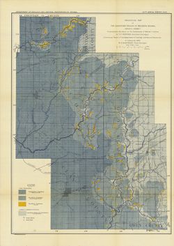
-
- Subject:
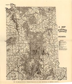
- Topical Subject: IGS Annual Reports, Topical Subject: Mines and mineral resources, Topical Subject: Road materials, and Geographic Subject: Monroe County (Ind.)
- Publisher:
- Indiana. Department of Geology and Natural Resources
- Date Created:
- 1906
- Identifier:
- VAC3073-M-01160
- Genre:
- Geological maps
- Geographic Location:
- Coordinates: W0864107 W0861903 N0392122 N0385936
- Related URL:
- Catalog URL: https://iucat.iu.edu/catalog/18299087
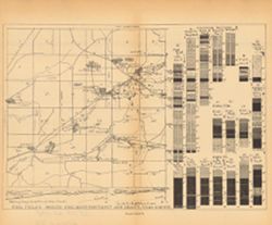
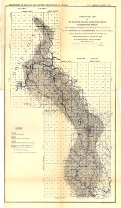
- Abstract:
- Alternate title: Illustrating the distribution of road materials in Monroe County. At head of alternate title: Fig. 53B. Shows roads, limestone, gravel, sand...
- Call Number:
- G4093.M7H5 1905 .M3
- Caption:
- Imprint: [Indianapolis] : [Indiana Dept. of Geology and Natural Resources], [1906]
- Physical Description:
- Scale: Approximately 1:171,000 and Dimensions: 26 x 22 cm
- Alternate Identifier:
- Alternate ID: 390726IP and Title Control Number: a18299087
- Persistent URL:
- https://purl.dlib.indiana.edu/iudl/images/VAC3073/VAC3073-M-01160
- Provenance:
- 30th Annual Report (1905) / Indiana. Department of Geology and Natural Resources.
-

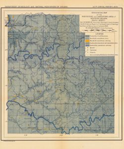
- Subject:
- Geographic Subject: Indiana, Geographic Subject: Ripley County (Ind.), Topical Subject: IGS Annual Reports, Geographic Subject: Jefferson County (Ind.), Topi...
- Creator:
- Cumings, E. R. (Edgar Roscoe), 1874-1967 and Foerste, Aug. F. (Aug. Frederic), 1862-1936
- Publisher:
- Indiana. Department of Geology and Natural Resources
- Date Created:
- 1908
- Identifier:
- VAC3073-M-01028
- Genre:
- Geological maps
- Geographic Location:
- Coordinates: W0854100 W0844600 N0391800 N0383300
- Related URL:
- Catalog URL: https://iucat.iu.edu/catalog/18307520
- Abstract:
- "Boundary after Foerste." Detached from: The stratigraphy and paleontology of the Cincinnati series of Indiana / E.R. Cumings. In Indiana Dept. ...
- Call Number:
- G4091.C57 1908 .M3
- Caption:
- Imprint: [Indianapolis] : [Indiana Dept. of Geology and Natural Resources], [1908]
- Physical Description:
- Dimensions: on sheet 60 x 51 cm and Scale: Approximately 1:126,720. 2 miles to the 1 inch
- Alternate Identifier:
- Title Control Number: a18307520 and Alternate ID: 390726IP
- Persistent URL:
- https://purl.dlib.indiana.edu/iudl/images/VAC3073/VAC3073-M-01028
- Provenance:
- 32nd Annual Report (1907) / Indiana. Department of Geology and Natural Resources.
-
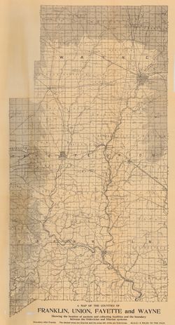
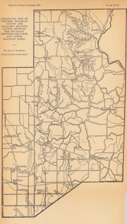
- Subject:
- Geographic Subject: Union County (Ind.), Geographic Subject: Franklin County (Ind.), Topical Subject: IGS Annual Reports, Geographic Subject: Indiana, Topica...
- Publisher:
- Indiana. Department of Geology and Natural Resources
- Date Created:
- 1908
- Identifier:
- VAC3073-M-00272
- Genre:
- Geological maps
- Related URL:
- Catalog URL: https://iucat.iu.edu/catalog/9676901
- Abstract:
- Showing the Location of sections and collecting localities and the boundary between the Ordovician and Silurian Systems. Detached from: The stratigraphy a...
- Call Number:
- QE109 .A2 1907 map p605
- Caption:
- Imprint: Indianapolis : 1908
- Physical Description:
- Dimensions: 67 x 37 cm and Scale: Approximately 1:126,720. 2 miles = 1 inch
- Alternate Identifier:
- Title Control Number: 390726IP
- Persistent URL:
- https://purl.dlib.indiana.edu/iudl/images/VAC3073/VAC3073-M-00272
- Provenance:
- 32nd Annual Report (1907) / Indiana. Department of Geology and Natural Resources.
-
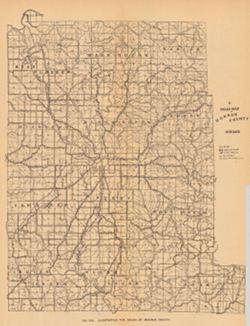
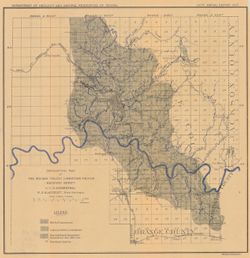
- Subject:
- Topical Subject: Roads, Topical Subject: IGS Annual Reports, and Geographic Subject: Monroe County (Ind.)
- Publisher:
- Indiana. Department of Geology and Natural Resources
- Date Created:
- 1906
- Identifier:
- VAC3073-M-00037
- Genre:
- Road maps
- Geographic Location:
- Coordinates: W0864107 W0861811 N0392126 N0385936
- Related URL:
- Catalog URL: https://iucat.iu.edu/catalog/18298783
- Abstract:
- Shows roads, improved roads, rural routes, rail roads, and road metal quarries. Alternate title: Illustrating the roads of Monroe County. At head of alternat...
- Call Number:
- G4093.M7P2 1905 .R6
- Caption:
- Imprint: Indianapolis : 1906
- Physical Description:
- Scale: Approximately 1:130,000 and Dimensions: 36 x 27 cm
- Alternate Identifier:
- Alternate ID: 390726IP and Title Control Number: a18298783
- Persistent URL:
- https://purl.dlib.indiana.edu/iudl/images/VAC3073/VAC3073-M-00037
- Provenance:
- 30th Annual Report (1905) / Indiana. Department of Geology and Natural Resources.
-
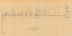
- Subject:
- Geographic Subject: Richmond (Ind.), Topical Subject: IGS Annual Reports, Geographic Subject: Madison (Ind.), Topical Subject: Stratigraphic correlation, Top...
- Creator:
- Cumings, E. R. (Edgar Roscoe), 1874-1967
- Publisher:
- Indiana. Department of Geology and Natural Resources
- Date Created:
- 1908
- Identifier:
- VAC3073-M-00056
- Genre:
- Charts and Geological cross-sections
- Geographic Location:
- Coordinates: W0852400 W0844800 N0395000 N0384000
- Related URL:
- Catalog URL: https://iucat.iu.edu/catalog/18298808
- Abstract:
- Includes 17 stratigraphic columns and correlation lines. Detached from: The stratigraphy and paleontology of the Cincinnati series of Indiana / E.R. Cumin...
- Call Number:
- G4091.C57 1908 .C86
- Caption:
- Imprint: [Indianapolis] : [Wm. B. Burford], [1908] and Imprint: [Indianapolis] : [Indiana Department of Geology and Natural Resources], [1908]
- Physical Description:
- Dimensions: on sheet 32 x 60 cm and Scale: Scale not given.
- Alternate Identifier:
- Title Control Number: a18298808 and Alternate ID: 390726IP
- Persistent URL:
- https://purl.dlib.indiana.edu/iudl/images/VAC3073/VAC3073-M-00056
- Provenance:
- 32nd Annual Report (1907) / Indiana. Department of Geology and Natural Resources.
-
- Subject:
- Topical Subject: IGS Annual Reports, Topical Subject: Land use surveys, and Geographic Subject: Indiana
- Creator:
- Collett, John, 1828-1899
- Publisher:
- Indiana. Department of Geology and Natural History
- Date Created:
- 1883
- Identifier:
- VAC3073-M-01145
- Genre:
- Outline maps and Thematic maps
- Geographic Location:
- Coordinates: W0880500 W0844700 N0414500 N0364600
- Related URL:
- Catalog URL: https://iucat.iu.edu/catalog/18174045
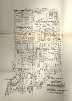
- Abstract:
- Showing the Districts as subdivided by the U.S. Surveys, together with each name and date of survey. The dotted lines are boundaries of Districts. Ebenezer ...
- Call Number:
- G4091.G46 1882 .C655
- Caption:
- Imprint: [Indianapolis] :, b[Indiana Dept. of Geology and Natural History],, and c[1882]
- Physical Description:
- Scale: Scale not given. and Dimensions: 35 x 27 cm
- Alternate Identifier:
- Alternate ID: 390725IP and Title Control Number: a18174045
- Persistent URL:
- https://purl.dlib.indiana.edu/iudl/images/VAC3073/VAC3073-M-01145
- Provenance:
- 12th Annual Report (1882) / Indiana. Department of Geology and Natural History.
-
An outline map of Indiana showing dates and places where treaties were held, ceding land to the U.S.
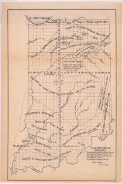
- Subject:
- Geographic Subject: Indiana, Topical Subject: Treaties, Topical Subject: Indian land transfers, and Topical Subject: IGS Annual Reports
- Creator:
- Collett, John, 1828-1899
- Publisher:
- Indiana. Department of Geology and Natural History
- Date Created:
- 1883
- Identifier:
- VAC3073-M-01104
- Genre:
- Outline maps and Thematic maps
- Geographic Location:
- Coordinates: W0850500 W0844700 N0414500 N0374600
- Related URL:
- Catalog URL: https://iucat.iu.edu/catalog/18173762
- Abstract:
- Showing dates and places where Treaties were held, Ceding Land to the U.S. This dotted line denotes boundaries of the different Treaties.
- Call Number:
- G4091.G46 1882 .C65
- Caption:
- Imprint: [Indianapolis] : [Indiana Dept. of Geology and Natural History], [1883]
- Physical Description:
- Dimensions: 32 x 21 cm and Scale: Approximately 1:1,680,000
- Alternate Identifier:
- Alternate ID: 390725IP and Title Control Number: a18173762
- Persistent URL:
- https://purl.dlib.indiana.edu/iudl/images/VAC3073/VAC3073-M-01104
- Provenance:
- 12th Annual Report (1882) / Indiana. Department of Geology and Natural History.
-
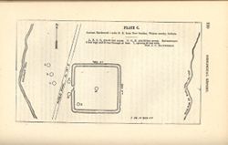
- Subject:
- Geographic Subject: New Garden (Ind. : Township), Topical Subject: Earthworks (Archaeology), and Topical Subject: IGS Annual Reports
- Creator:
- Macpherson, J. C. (John C.)
- Publisher:
- Indiana. Geological Survey
- Date Created:
- 1879
- Identifier:
- VAC3073-M-01550
- Genre:
- Pictorial maps
- Geographic Location:
- Coordinates: W0845400 W0845300 N0395800 N0395700
- Related URL:
- Catalog URL: https://iucat.iu.edu/catalog/18387636
- Abstract:
- At head of title: Plate C. Shows streams, pits, and earthwork [Indiana Adena Square?] with measurements. Detached from: Eighth, ninth, and tenth annual re...
- Call Number:
- G4094.N438 1978 .M33
- Caption:
- Imprint: [Indianapolis] : [Indianapolis Journal Company, State printers], [1879] and Imprint: [Indianapolis] : [Geological Survey of Indiana], [1879]
- Physical Description:
- Dimensions: on sheet 14 x 21 cm and Scale: Approximately 1:6,000. 1 inch = 500 ft.
- Alternate Identifier:
- Alternate ID: 390723IP and Title Control Number: a18387636
- Persistent URL:
- https://purl.dlib.indiana.edu/iudl/images/VAC3073/VAC3073-M-01550
- Provenance:
- 8th, 9th, and 10th Annual Reports (1876, 1877, 1878) / Indiana. Geological Survey.
-
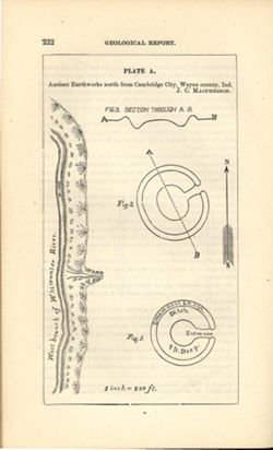
- Subject:
- Geographic Subject: Cambridge City (Ind.), Topical Subject: Henges, and Topical Subject: IGS Annual Reports
- Creator:
- Macpherson, J. C. (John C.)
- Publisher:
- Indiana. Geological Survey
- Date Created:
- 1879
- Identifier:
- VAC3073-M-01551
- Genre:
- Pictorial maps
- Geographic Location:
- Coordinates: W0851016 W0851004 N0395012 N0395001
- Related URL:
- Catalog URL: https://iucat.iu.edu/catalog/18387638
- Abstract:
- At head of title: Plate A. Relief shown by profile and spot heights. Includes pictorial map of west branch of Whitewater River and three figures showing heig...
- Call Number:
- G4094.C15E15 1878 .M33
- Caption:
- Imprint: [Indianapolis] : [Indianapolis Journal Company, State printers], [1879] and Imprint: [Indianapolis] : [Geological Survey of Indiana], [1879]
- Physical Description:
- Dimensions: on sheet 22 x 13 cm and Scale: Approximately 1:2,400. 1 inch = 200 ft.
- Alternate Identifier:
- Alternate ID: 390723IP and Title Control Number: a18387638
- Persistent URL:
- https://purl.dlib.indiana.edu/iudl/images/VAC3073/VAC3073-M-01551
- Provenance:
- 8th, 9th, and 10th Annual Reports (1876, 1877, 1878) / Indiana. Geological Survey.
-
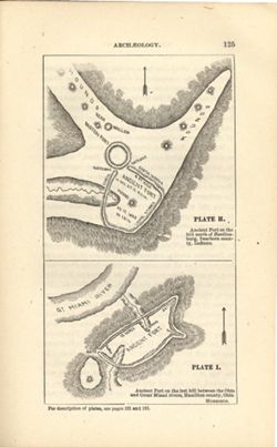
- Subject:
- Topical Subject: IGS Annual Reports, Topical Subject: Mounds, Topical Subject: Fortification, Prehistoric, Topical Subject: Indians of North America, Geograp...
- Creator:
- Morrison, Samuel (Civil engineer)
- Publisher:
- Indiana. Geological Survey
- Date Created:
- 1879
- Identifier:
- VAC3073-M-01548
- Genre:
- Pictorial maps
- Geographic Location:
- Coordinates: W0850758 W0844909 N0391829 N0385607
- Related URL:
- Catalog URL: https://iucat.iu.edu/catalog/18387663
- Abstract:
- At head of first title: Plate H , At head of second title: Plate I. Relief shown by hachures and spot heights. Shows prehistoric forts [Miami Fort and Oberti...
- Call Number:
- QE109 .A2
- Caption:
- Imprint: [Indianapolis] : [Geological Survey of Indiana], [1879] and Imprint: [Indianapolis] : [Indianapolis Journal Company, State printers], [1879]
- Physical Description:
- Dimensions: 22 x 14 cm and Scale: Scale not given.
- Alternate Identifier:
- Title Control Number: a18387663 and Alternate ID: 390723IP
- Persistent URL:
- https://purl.dlib.indiana.edu/iudl/images/VAC3073/VAC3073-M-01548
- Provenance:
- 8th, 9th, and 10th Annual Reports (1876, 1877, 1878) / Indiana. Geological Survey.
-
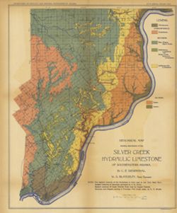
- Subject:
- Geographic Subject: Lawrence County (Ind.), Topical Subject: Stone-cutting, Topical Subject: Limestone industry, Geographic Subject: Bedford (Ind.), and Topi...
- Creator:
- Blatchley, Raymond S. (Raymond Sillliman)
- Publisher:
- Indiana. Department of Geology and Natural Resources
- Date Created:
- 1908
- Identifier:
- VAC3073-M-00628
- Genre:
- Road maps and Thematic maps
- Geographic Location:
- Coordinates: W0863134 W0862736 N0385324 N0385042
- Related URL:
- Catalog URL: https://iucat.iu.edu/catalog/18299189
- Abstract:
- "The 15 etching maps of the individual quarries or quarry districts, have been written and prepared by Raymond S. Blatchley from data gathered by him pe...
- Call Number:
- G4094.B3M2 1907 .B53
- Caption:
- Imprint: [Indianapolis] : [Indiana Department of Geology and Natural Resources], [1908]
- Physical Description:
- Dimensions: 23 x 20 cm and Scale: Scale not given.
- Alternate Identifier:
- Alternate ID: 390726IP and Title Control Number: a18299189
- Persistent URL:
- https://purl.dlib.indiana.edu/iudl/images/VAC3073/VAC3073-M-00628
- Provenance:
- 32nd Annual Report (1907) / Indiana. Department of Geology and Natural Resources.
-
![Bloomington [stone mills and quarries]](https://iiif.uits.iu.edu/iiif/2/2z10xt541%2Ffiles%2Fe56b5fe6-690b-41df-b566-a4f36f32b932/full/250,/0/default.jpg)
- Subject:
- Topical Subject: IGS Annual Reports, Topical Subject: Abandoned quarries, Topical Subject: Limestone industry, Geographic Subject: Bloomington (Ind.), and To...
- Creator:
- Blatchley, Raymond S. (Raymond Sillliman)
- Publisher:
- Indiana. Department of Geology and Natural Resources
- Date Created:
- 1908
- Identifier:
- VAC3073-M-01006
- Genre:
- Thematic maps
- Geographic Location:
- Coordinates: W0863336 W0863018 N0391047 N0390805
- Related URL:
- Catalog URL: https://iucat.iu.edu/catalog/18298788
- Abstract:
- "The 15 etching maps of the individual quarries or quarry districts, have been written and prepared by Raymond S. Blatchley from data gathered by him pe...
- Call Number:
- G4094.B5 1907 .B53
- Caption:
- Imprint: [Indianapolis] : [Wm. B. Burford], [1908] and Imprint: [Indianapolis] : [Indiana Department of Geology and Natural Resources], [1908]
- Physical Description:
- Scale: Approximately 1:17,000 and Dimensions: 23 x 21 cm
- Alternate Identifier:
- Alternate ID: 390726IP and Title Control Number: a18298788
- Persistent URL:
- https://purl.dlib.indiana.edu/iudl/images/VAC3073/VAC3073-M-01006
- Provenance:
- 32nd Annual Report (1907) / Indiana. Department of Geology and Natural Resources.
-
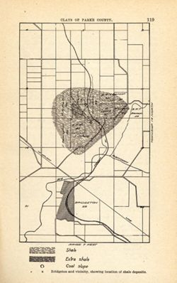
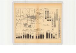
- Subject:
- Geographic Subject: Bridgeton Region (Ind.), Topical Subject: Mines and mineral resources, Geographic Subject: Parke County (Ind.), Topical Subject: IGS Annu...
- Publisher:
- Indiana. Department of Geology and Natural Resources
- Date Created:
- 1905
- Identifier:
- VAC3073-M-01585
- Genre:
- Geological maps
- Geographic Location:
- Coordinates: W0871115 W0870900 N0394130 N0393800
- Related URL:
- Catalog URL: https://iucat.iu.edu/catalog/18279221
- Abstract:
- Shows location of shale, extra shale, and coal slope. "Clays of Parke County." Detached from: The clays and clay industries of Indiana / W. S. B...
- Call Number:
- G4093.P2H5 1904 .B75
- Caption:
- Imprint: [Indianapolis] : [Indiana Department of Geology and Natural Resources], [1905] and Imprint: [Indianapolis] : [Wm. B. Burford], [1905]
- Physical Description:
- Scale: Scale not given. and Dimensions: on sheet 22 x 14 cm
- Alternate Identifier:
- Alternate ID: 390726IP and Title Control Number: a18279221
- Persistent URL:
- https://purl.dlib.indiana.edu/iudl/images/VAC3073/VAC3073-M-01585
- Provenance:
- 29th Annual Report (1904) / Indiana. Department of Geology and Natural Resources.
-
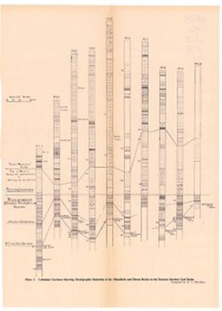
- Subject:
- Topical Subject: Geology, Stratigraphic, Topical Subject: Startigraphic correlation, Topical Subject: Coal, Geographic Subject: Indiana, and Topical Subject:...
- Publisher:
- Indiana. Department of Geology and Natural Resources
- Date Created:
- 1899
- Identifier:
- VAC3073-M-00119
- Genre:
- Geological cross-sections
- Geographic Location:
- Coordinates: W0880500 W0844700 N0414500 N0374600
- Related URL:
- Catalog URL: https://iucat.iu.edu/catalog/18276213
- Abstract:
- Includes stratigraphic columns, correlation lines, and depth measurements. Plate IX. Columnar sections included in this diagram are also shown accompanying a...
- Call Number:
- G4091.H9 1898 .C43
- Caption:
- Imprint: [Indianapolis] : [Indiana Department of Geology and Natural Resources], [1899]
- Physical Description:
- Dimensions: 27 x 23 cm and Scale: Scale not given.
- Alternate Identifier:
- Title Control Number: a18276213 and Alternate ID: 390726IP
- Persistent URL:
- https://purl.dlib.indiana.edu/iudl/images/VAC3073/VAC3073-M-00119
- Provenance:
- 23rd Annual Report (1898) / Indiana. Department of Geology and Natural Resources.
-
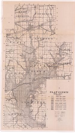
- Subject:
- Topical Subject: IGS Annual Reports, Geographic Subject: Clay County (Ind.), and Topical Subject: Soils
- Creator:
- Shannon, M. E. and Shannon, C. W. (Charles William), 1879-1934
- Publisher:
- Indiana. Department of Geology and Natural Resources
- Date Created:
- 1912
- Identifier:
- VAC3073-M-01093
- Genre:
- Thematic maps
- Related URL:
- Catalog URL: https://iucat.iu.edu/catalog/4022271
- Abstract:
- Detached from: Soil survey of Clay, Knox, Sullivan and Vigo counties / by Charles W. Shannon. In Thirty-sixth annual report of Department of Geology and Natu...
- Call Number:
- QE109 .A2 1911 map p170
- Caption:
- Imprint: [Indianapolis] : [Department of Geology and Natural Resources, Indiana], [1912] [Indianapolis] : [Wm. B. Burford], [1912]
- Physical Description:
- Scale: Approximately 1:63,360 and Dimensions: 80 x 45 cm
- Alternate Identifier:
- Title Control Number: 390726IP
- Persistent URL:
- https://purl.dlib.indiana.edu/iudl/images/VAC3073/VAC3073-M-01093
- Provenance:
- 36th Annual Report (1911) / Indiana. Department of Geology and Natural Resources.
-
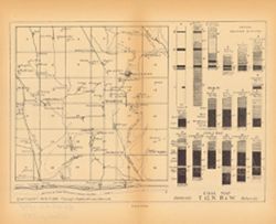
- Subject:
- Topical Subject: Coal reserves, Geographic Subject: Jefferson (Ind. : Township), Topical Subject: IGS Annual Reports, and Topical Subject: Geology, Stratigra...
- Publisher:
- Indiana. Department of Geology and Natural Resources
- Date Created:
- 1899
- Identifier:
- VAC3073-M-00285
- Genre:
- Geological maps and Geological cross-sections
- Geographic Location:
- Coordinates: W0870430 W0865115 N0391900 N0391000
- Related URL:
- Catalog URL: https://iucat.iu.edu/catalog/18418134
- Abstract:
- Relief shown by profile. 13 columnar sections showing coal measures and location map for Jefferson Township, including Coal City and Arney, in Owen County, I...
- Call Number:
- G4094.J384H9 1898 .C63
- Caption:
- Imprint: [Indianapolis] : [Wm. B. Burford], [1899] and Imprint: [Indianapolis] : [Indiana, Dept. of Geology and Natural History], [1899]
- Physical Description:
- Dimensions: 23 x 27 cm and Scale: Approximately 1:63,360. Vertical scale varies
- Alternate Identifier:
- Alternate ID: 390726IP and Title Control Number: a18418134
- Persistent URL:
- https://purl.dlib.indiana.edu/iudl/images/VAC3073/VAC3073-M-00285
- Provenance:
- 23rd Annual Report (1898) / Indiana. Department of Geology and Natural Resources.
-
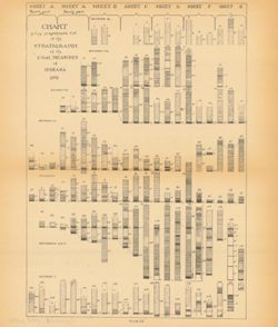
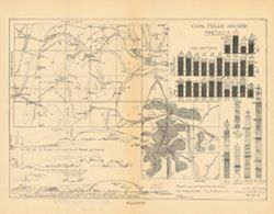
Coal chart : Indiana measures showing thickness, partings, roof and floor of the principal coal beds
- Subject:
- Topical Subject: Coal, Geographic Subject: Indiana, Topical Subject: Startigraphic correlation, Topical Subject: Geology, Stratigraphic, and Topical Subject:...
- Creator:
- Ashley, Geo. H. (George Hall), 1866-1951
- Publisher:
- Indiana. Department of Geology and Natural Resources
- Date Created:
- 1909
- Identifier:
- VAC3073-M-00243
- Genre:
- Geological cross-sections
- Geographic Location:
- Coordinates: W0880500 W0844700 N0414500 N0374600
- Related URL:
- Catalog URL: https://iucat.iu.edu/catalog/18307674
- Abstract:
- Includes several hundred stratigraphic columns showing coal measurements for sites across Indiana and correlation lines. Detached from: The coal deposits ...
- Call Number:
- G4091.C57 1907 .C63
- Caption:
- Imprint: [Indianapolis] : [Indiana Department of Geology and Natural Resources], [1909]
- Physical Description:
- Dimensions: 41 x 54 cm and Scale: Horizontal scale not given. Vertical scale approximately 1:12. 1 inch = 8 feet
- Alternate Identifier:
- Title Control Number: a18307674 and Alternate ID: 390726IP
- Persistent URL:
- https://purl.dlib.indiana.edu/iudl/images/VAC3073/VAC3073-M-00243
- Provenance:
- 33rd Annual Report (1908) / Indiana. Department of Geology and Natural Resources.
-
- Subject:
- Topical Subject: Coal reserves, Topical Subject: IGS Annual Reports, Topical Subject: Geology, Stratigraphic, and Geographic Subject: Wright (Ind. : Township)
- Publisher:
- Indiana. Department of Geology and Natural Resources
- Date Created:
- 1899
- Identifier:
- VAC3073-M-00282
- Genre:
- Geological maps and Geological cross-sections
- Geographic Location:
- Coordinates: W0871435 W0870743 N0391018 N0390513
- Related URL:
- Catalog URL: https://iucat.iu.edu/catalog/18417962
- Abstract:
- 13 columnar sections showing coal measures with location map for Wright Township in Greene County, Indiana. Plate XL. Detached from: The coal deposits of ...
- Call Number:
- G4094.W79H9 1898 .I5
- Caption:
- Imprint: [Indianapolis] : [Wm. B. Burford], [1899] and Imprint: [Indianapolis] : [Indiana. Department of Geology and Natural Resources], [1899]
- Physical Description:
- Dimensions: 23 x 27 cm and Scale: Approximately 1:63,360. Vertical scale varies
- Alternate Identifier:
- Alternate ID: 390726IP and Title Control Number: a18417962
- Persistent URL:
- https://purl.dlib.indiana.edu/iudl/images/VAC3073/VAC3073-M-00282
- Provenance:
- 23rd Annual Report (1898) / Indiana. Department of Geology and Natural Resources.
-
- Subject:
- Geographic Subject: Vigo County (Ind.), Topical Subject: Geology, Stratigraphic, Topical Subject: Coal reserves, Topical Subject: IGS Annual Reports, and Top...
- Publisher:
- Indiana. Department of Geology and Natural Resources
- Date Created:
- 1899
- Identifier:
- VAC3073-M-00303
- Genre:
- Geological cross-sections and Geological maps
- Geographic Location:
- Coordinates: W0872400 W0865700 N0393900 N0393000
- Related URL:
- Catalog URL: https://iucat.iu.edu/catalog/18214647
- Abstract:
- Relief shown by profile. Includes map showing locations of coal fields in Vigo County, Indiana, as well as 2 geological cross sections along the north and so...
- Call Number:
- G4093.V5H9 1898 .C63
- Caption:
- Imprint: [Indianapolis] : [Indiana Department of Geology and Natural Resources], [1899]
- Physical Description:
- Scale: Approximately 1:63,360. Vertical scale varies and Dimensions: 23 x 27 cm
- Alternate Identifier:
- Title Control Number: a18214647 and Alternate ID: 390726IP
- Persistent URL:
- https://purl.dlib.indiana.edu/iudl/images/VAC3073/VAC3073-M-00303
- Provenance:
- 23rd Annual Report (1898) / Indiana. Department of Geology and Natural Resources.
-
- Subject:
- Topical Subject: IGS Annual Reports, Topical Subject: Coal reserves, Topical Subject: Coalfields, Topical Subject: Stratigraphic correlation, Geographic Subj...
- Publisher:
- Indiana. Department of Geology and Natural Resources
- Date Created:
- 1899
- Identifier:
- VAC3073-M-00691
- Genre:
- Geological cross-sections and Geological maps
- Geographic Location:
- Coordinates: W0865330 W0864630 N0384130 N0383830
- Related URL:
- Catalog URL: https://iucat.iu.edu/catalog/18214656
- Abstract:
- Relief shown by profile. Includes index map showing locations of coal fields in southern Martin County, 29 stratigraphic columns, correlation lines, and 4 ge...
- Call Number:
- G4093.M5H9 1898 .C63
- Caption:
- Imprint: [Indianapolis] : [Indiana Department of Geology and Natural Resources], [1899]
- Physical Description:
- Scale: Approximately 1:63,360 and Dimensions: 21 x 27 cm
- Alternate Identifier:
- Alternate ID: 390726IP and Title Control Number: a18214656
- Persistent URL:
- https://purl.dlib.indiana.edu/iudl/images/VAC3073/VAC3073-M-00691
- Provenance:
- 23rd Annual Report (1898) / Indiana. Department of Geology and Natural Resources.
-
- Subject:
- Geographic Subject: Washington (Ind.), Topical Subject: Coal reserves, Topical Subject: Geology, Stratigraphic, Geographic Subject: Daviess County (Ind.), To...
- Publisher:
- Indiana. Department of Geology and Natural Resources
- Date Created:
- 1899
- Identifier:
- VAC3073-M-00113
- Genre:
- Geological cross-sections, Index maps, and Geological maps
- Geographic Location:
- Coordinates: W0871341 W0870713 N0384107 N0383731
- Related URL:
- Catalog URL: https://iucat.iu.edu/catalog/18214666
- Abstract:
- Relief shown by profile. Includes index map showing locations of coal fields in around Washington in Daviess County, Indiana, 25 stratigraphic columns, corre...
- Call Number:
- G4093.D2H9 1898 .C63
- Caption:
- Imprint: [Indianapolis] : [Indiana Department of Geology and Natural Resources], [1899]
- Physical Description:
- Dimensions: 23 x 26 cm and Scale: Approximately 1:63,360
- Alternate Identifier:
- Alternate ID: 390726IP and Title Control Number: a18214666
- Persistent URL:
- https://purl.dlib.indiana.edu/iudl/images/VAC3073/VAC3073-M-00113
- Provenance:
- 23rd Annual Report (1898) / Indiana. Department of Geology and Natural Resources.
-
- Subject:
- Topical Subject: Geology, Stratigraphic, Topical Subject: Coalfields, Topical Subject: IGS Annual Reports, Geographic Subject: Clay County (Ind.), Topical Su...
- Publisher:
- Indiana. Department of Geology and Natural Resources
- Date Created:
- 1899
- Identifier:
- VAC3073-M-00248
- Genre:
- Geological cross-sections, Index maps, and Geological maps
- Geographic Location:
- Coordinates: W0870823 W0870225 N0393036 N0392623
- Related URL:
- Catalog URL: https://iucat.iu.edu/catalog/18214672
- Abstract:
- Caption title: East-west section through Hoosierville and Asherville. Relief shown by profile. Index map showing locations of coal fields around Hoosierville...
- Call Number:
- G4093.C5H9 1898 .C63
- Caption:
- Imprint: [Indianapolis] : [Indiana Department of Geology and Natural Resources], [1899]
- Physical Description:
- Dimensions: 23 x 28 cm and Scale: Approximately 1:63,360
- Alternate Identifier:
- Alternate ID: 390726IP and Title Control Number: a18214672
- Persistent URL:
- https://purl.dlib.indiana.edu/iudl/images/VAC3073/VAC3073-M-00248
- Provenance:
- 23rd Annual Report (1898) / Indiana. Department of Geology and Natural Resources.
-
- Subject:
- Geographic Subject: Indiana, Topical Subject: Mines and mineral resources, Topical Subject: IGS Annual Reports, Topical Subject: Geology, Stratigraphic--Penn...
- Creator:
- Blatchley, Raymond S. (Raymond Sillliman)
- Publisher:
- Indiana. Department of Geology and Natural Resources
- Date Created:
- 1911
- Identifier:
- VAC3073-M-01084
- Genre:
- Geological cross-sections
- Geographic Location:
- Coordinates: W0880500 W0844700 N0414500 N0374600
- Related URL:
- Catalog URL: https://iucat.iu.edu/catalog/18418391
- Abstract:
- Title from caption. At head of title: "Plate I." Compiled by R.S. Blatchley. 10 sections on one sheet. Geologic columns showing stratigraphic layer...
- Call Number:
- G4091.C57 1910 .B53
- Caption:
- Imprint: [Indianapolis] : [Indiana Department of Geology and Natural Resources], [1911] and Imprint: [Indianapolis] : [Wm. B. Burford], [1911]
- Physical Description:
- Scale: Scale not given. Vertical scale approximately 1:2,100 and Dimensions: on sheet 37 x 26 cm
- Alternate Identifier:
- Title Control Number: a18418391 and Alternate ID: 390726IP
- Persistent URL:
- https://purl.dlib.indiana.edu/iudl/images/VAC3073/VAC3073-M-01084
- Provenance:
- 35th Annual Report (1910) / Indiana. Department of Geology and Natural Resources.
-
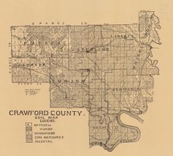
- Subject:
- Topical Subject: IGS Annual Reports, Topical Subject: Soils, and Geographic Subject: Crawford County (Ind.)
- Creator:
- Shannon, C. W. (Charles William), 1879-1934
- Publisher:
- Indiana. Department of Geology and Natural Resources
- Date Created:
- 1909
- Identifier:
- VAC3073-M-00856
- Genre:
- Thematic maps
- Geographic Location:
- Coordinates: W0864052 W0861444 N0382520 N0380617
- Related URL:
- Catalog URL: https://iucat.iu.edu/catalog/16091037
- Abstract:
- Shows school houses, caves, public roads, and railroads. Detached from: A soil survey of four counties of southern Indiana / Chas. W. Shannon and L.C. Sni...
- Call Number:
- G4093.C7J3 1908 .I53
- Caption:
- Imprint: [Indianapolis] : [Wm. B. Burford], [1909] and Imprint: [Indianapolis] : [Indiana Department of Geology and Natural Resources], [1909]
- Physical Description:
- Scale: Approximately 1:130,000 and Dimensions: on sheet 32 x 36 cm
- Alternate Identifier:
- Title Control Number: a16091037 and Alternate ID: 390726IP
- Persistent URL:
- https://purl.dlib.indiana.edu/iudl/images/VAC3073/VAC3073-M-00856
- Provenance:
- 33rd Annual Report (1908) / Indiana. Department of Geology and Natural Resources.
-
- Subject:
- Topical Subject: Geology, Topical Subject: IGS Annual Reports, Topical Subject: Limestone, Geographic Subject: Oolitic (Ind.), Geographic Subject: Lawrence C...
- Publisher:
- Indiana. Department of Geology and Natural Resources
- Date Created:
- 1897
- Identifier:
- VAC3073-M-01137
- Genre:
- Geological maps
- Geographic Location:
- Coordinates: W0863308 W0862727 N0385559 N0385035
- Related URL:
- Catalog URL: https://iucat.iu.edu/catalog/17036030
- Abstract:
- To accompany the report on the Bedford oölitic limestone, T.C. Hopkins and C.E. Siebenthal, assistant geologists : annual report of the Department of Ge...
- Call Number:
- G4094.B3C5 1896 .D4
- Caption:
- Imprint: [Indianapolis] : Dept. of Geology and Natural Resources of Indiana, [1897] and Imprint: Indianapolis, Ind. : Wm. B. Burford, Lith, [1897]
- Physical Description:
- Scale: Approximatley 1:31,680. 1 mile = 2 in. and Dimensions: 33 x 28 cm
- Alternate Identifier:
- Title Control Number: a17036030 and Alternate ID: 390726IP
- Persistent URL:
- https://purl.dlib.indiana.edu/iudl/images/VAC3073/VAC3073-M-01137
- Provenance:
- 21st Annual Report (1896) / Indiana. Department of Geology and Natural Resources.
-
- Subject:
- Topical Subject: Geology, Geographic Subject: Bloomington (Ind.), Topical Subject: Limestone, Geographic Subject: Monroe County (Ind.), and Topical Subject: ...
- Publisher:
- Indiana. Department of Geology and Natural Resources
- Date Created:
- 1897
- Identifier:
- VAC3073-M-01138
- Genre:
- Geological maps
- Geographic Location:
- Coordinates: W0863343 W0862934 N0391127 N0390900
- Related URL:
- Catalog URL: https://iucat.iu.edu/catalog/17035930
- Abstract:
- to accompany the report on the Bedford oölitic limestone, T.C. Hopkins and C.E. Siebenthal, assistant geologists : annual report of the Department of Ge...
- Call Number:
- G4094.B5C5 1896 .D4
- Caption:
- Imprint: Indianapolis, Ind. : Wm. B. Burford, Lith., [1897] and Imprint: [Indianapolis] : Dept. of Geology and Natural Resources of Indiana, [1897]
- Physical Description:
- Scale: Approximately 1:31,680. 1 mile = 2 in. and Dimensions: 17 x 20 cm
- Alternate Identifier:
- Alternate ID: 390726IP and Title Control Number: a17035930
- Persistent URL:
- https://purl.dlib.indiana.edu/iudl/images/VAC3073/VAC3073-M-01138
- Provenance:
- 21st Annual Report (1896) / Indiana. Department of Geology and Natural Resources.
-
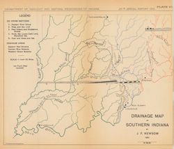
- Subject:
- Topical Subject: Geology, Stratigraphic, Topical Subject: IGS Annual Reports, Geographic Subject: Indiana, and Topical Subject: Watersheds
- Creator:
- Newsom, John F. (John Flesher), 1869-1928
- Publisher:
- Indiana. Department of Geology and Natural Resources
- Date Created:
- 1902
- Identifier:
- VAC3073-M-00234
- Genre:
- Thematic maps and Geological cross-sections
- Geographic Location:
- Coordinates: W0880500 W0844700 N0395100 N0374600
- Related URL:
- Catalog URL: https://iucat.iu.edu/catalog/18279215
- Abstract:
- Shows eastern, central, and western drainage areas in southern Indiana, the southern limit of the ice front after Leverett, and geological cross-sections in ...
- Call Number:
- G4091.C315 1901 .N49
- Caption:
- Imprint: Indianapolis, Ind. : Wm. B. Burford, Lith., [1902]
- Physical Description:
- Dimensions: on sheet 22 x 26 cm and Scale: Approximately 1:1,267,200. 1 inch = 20 miles
- Alternate Identifier:
- Alternate ID: 390726IP and Title Control Number: a18279215
- Persistent URL:
- https://purl.dlib.indiana.edu/iudl/images/VAC3073/VAC3073-M-00234
- Provenance:
- 26th Annual Report (1901) / Indiana. Department of Geology and Natural Resources.
-
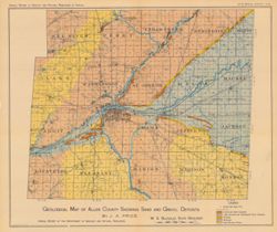
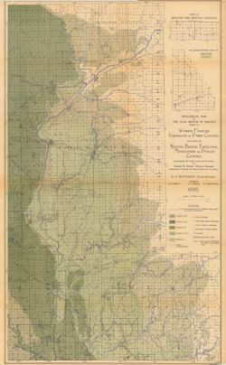
- Subject:
- Topical Subject: IGS Annual Reports, Topical Subject: Sand, Topical Subject: Glacial landforms, Geographic Subject: Allen County (Ind.), Topical Subject: Roa...
- Creator:
- Price, J. A.
- Publisher:
- Indiana. Department of Geology and Natural Resources
- Date Created:
- 1906
- Identifier:
- VAC3073-M-00046
- Genre:
- Geological maps
- Geographic Location:
- Coordinates: W0852020 W0844810 N0411616 N0405501
- Related URL:
- Catalog URL: https://iucat.iu.edu/catalog/18298916
- Abstract:
- Shows roads, gravel and sand deposits, lake bottoms and abandoned river channels, beaches, moraines, and inter-moranic plains. Also shows cemeteries and chur...
- Call Number:
- G4093.A4H5 1905 .P7
- Caption:
- Imprint: [Indianapolis] : [Indiana Department of Geology and Natural Resources], [1906]
- Physical Description:
- Dimensions: 38 x 45 cm and Scale: Approximately 1:126,720. 2 miles = 1 inch
- Alternate Identifier:
- Alternate ID: 390726IP and Title Control Number: a18298916
- Persistent URL:
- https://purl.dlib.indiana.edu/iudl/images/VAC3073/VAC3073-M-00046
- Provenance:
- 30th Annual Report (1905) / Indiana. Department of Geology and Natural Resources.
-
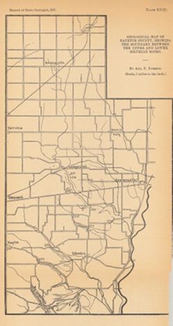
- Subject:
- Topical Subject: Mines and mineral resources, Topical Subject: Geology, Geographic Subject: Fayette County (Ind.), and Topical Subject: IGS Annual Reports
- Creator:
- Foerste, Aug. F. (Aug. Frederic), 1862-1936
- Publisher:
- Indiana. Department of Geology and Natural Resources
- Date Created:
- 1898
- Identifier:
- VAC3073-M-00063
- Genre:
- Geological maps
- Geographic Location:
- Coordinates: W0851831 W0850639 N0394639 N0393044
- Related URL:
- Catalog URL: https://iucat.iu.edu/catalog/17035593
- Abstract:
- Plate XVIII. Detached from: A report on the Niagara limestone quarries of Decatur, Franklin and Fayette Counties ... / August F. Foerste. In Indiana Departme...
- Call Number:
- G4093.F3C5 1898 .F64
- Caption:
- Imprint: [Indianapolis] : [Wm. B. Burford], [1898] and Imprint: [Indiana] : [Department of Geology and Natural Resources], [1898]
- Physical Description:
- Scale: Approximately 1:126,720 and Dimensions: 26 x 14 cm
- Alternate Identifier:
- Title Control Number: a17035593 and Alternate ID: 390726IP
- Persistent URL:
- https://purl.dlib.indiana.edu/iudl/images/VAC3073/VAC3073-M-00063
- Provenance:
- 22nd Annual Report (1897) / Indiana. Department of Geology and Natural Resources.
-
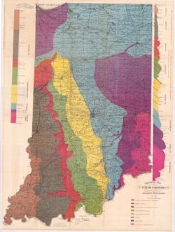
- Subject:
- Topical Subject: IGS Annual Reports, Topical Subject: Geology, Stratigraphic, Topical Subject: Mines and mineral resources, Geographic Subject: Indiana, and ...
- Creator:
- Collett, John, 1828-1899
- Publisher:
- Indiana. Department of Geology and Natural History
- Date Created:
- 1881
- Identifier:
- VAC3073-M-00094
- Genre:
- Geological cross-sections and Geological maps
- Geographic Location:
- Coordinates: W0880000 W0844500 N0414500 N0375200
- Related URL:
- Catalog URL: https://iucat.iu.edu/catalog/18174204
- Abstract:
- 1 map and 2 sections on 1 sheet. Shows county seats, townships, towns & post offices, railroads, creeks, and coal measures. Patton and Gray described as ...
- Call Number:
- G4091.C5 1883 .C65
- Caption:
- Imprint: Indianapolis : Wm. B. Burford, Lith., [1884]
- Physical Description:
- Dimensions: 86 x 63 cm and Scale: Approximately 1:570,240. 9 miles to the inch
- Alternate Identifier:
- Alternate ID: 390725IP and Title Control Number: a18174204
- Persistent URL:
- https://purl.dlib.indiana.edu/iudl/images/VAC3073/VAC3073-M-00094
- Provenance:
- 13th Annual Report (1883) / Indiana. Department of Geology and Natural History.
-
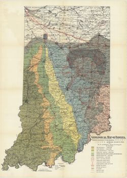
- Subject:
- Topical Subject: Mines and mineral resources, Topical Subject: Geology, Topical Subject: IGS Annual Reports, Topical Subject: Geology, Stratigraphic, Geograp...
- Publisher:
- Indiana. Department of Geology and Natural Resources
- Date Created:
- 1885
- Identifier:
- VAC3073-M-00075
- Genre:
- Geological cross-sections and Geological maps
- Geographic Location:
- Coordinates: W0880500 W0844700 N0414500 N0374600
- Related URL:
- Catalog URL: https://iucat.iu.edu/catalog/18437099
- Abstract:
- Variant title: Geological map of Indiana, revised and corrected. 1 map and 2 sections on 1 sheet. Shows county seats, townships, towns & post offices, ra...
- Call Number:
- QE109 .A2 1884
- Caption:
- Imprint: Indianapolis : [Indiana Department of Geology and Natural History], [1885] and Imprint: Indianapolis : Wm. B. Burford, [1885]
- Physical Description:
- Dimensions: 85 x 63 cm and Scale: Approximately 1:570,240. 9 miles to the inch
- Alternate Identifier:
- Alternate ID: 390725IP and Title Control Number: a18437099
- Persistent URL:
- https://purl.dlib.indiana.edu/iudl/images/VAC3073/VAC3073-M-00075
- Provenance:
- 14th Annual Report (1884) / Indiana. Department of Geology and Natural History.
-
- Subject:
- Topical Subject: IGS Annual Reports, Topical Subject: Geology, and Geographic Subject: Indiana
- Creator:
- Gorby, S. S. (Sylvester Scott)
- Publisher:
- Indiana. Department of Geology and Natural Resources
- Date Created:
- 1894
- Identifier:
- VAC3073-M-01252
- Genre:
- Geological maps
- Related URL:
- Catalog URL: https://iucat.iu.edu/catalog/4022270
- Call Number:
- QE109 .A2
- Caption:
- Imprint: Wm. B. Burford, Lith, Indianapolis
- Physical Description:
- Scale: Approximately 1:570,240. 9 miles to the inch
- Persistent URL:
- https://purl.dlib.indiana.edu/iudl/images/VAC3073/VAC3073-M-01252
- Provenance:
- 18th Annual Report (1893) / Indiana. Department of Geology and Natural Resources.
-
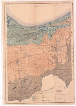
- Subject:
- Geographic Subject: Lake County (Ind.), Topical Subject: IGS Annual Reports, Geographic Subject: Porter County (Ind.), Topical Subject: Geology, and Topical ...
- Creator:
- Ashley, Geo. H. (George Hall), 1866-1951
- Publisher:
- Indiana. Department of Geology and Natural Resources
- Date Created:
- 1898
- Identifier:
- VAC3073-M-00806
- Genre:
- Geological maps
- Geographic Location:
- Coordinates: W0873136 W0865435 N0414259 N0410943
- Related URL:
- Catalog URL: https://iucat.iu.edu/catalog/17035654
- Abstract:
- Shows lakes, beaches, sand-dune area, morainic area, till plains, crest of moraine, and Kankakee Marsh area. Detached from: The geology of Lake and Porter...
- Call Number:
- G4093.L3C5 1897 .A8
- Caption:
- Imprint: [Indianapolis] : Department of Geology and Natural Resources of Indiana, [1898] and Imprint: Indianapolis, Ind. : Wm. B. Burford, lith., [1898]
- Physical Description:
- Dimensions: 55 x 42 cm and Scale: Approximately 1:126,720. 2 miles = 1 inch
- Alternate Identifier:
- Title Control Number: a17035654 and Alternate ID: 390726IP
- Persistent URL:
- https://purl.dlib.indiana.edu/iudl/images/VAC3073/VAC3073-M-00806
- Provenance:
- 22nd Annual Report (1897) / Indiana. Department of Geology and Natural Resources.
-
- Subject:
- Geographic Subject: Ripley County (Ind.), Topical Subject: Geology, Topical Subject: IGS Annual Reports, Topical Subject: Geology, Stratigraphic--Silurian, a...
- Creator:
- Foerste, Aug. F. (Aug. Frederic), 1862-1936
- Publisher:
- Indiana. Department of Geology and Natural Resources
- Date Created:
- 1897
- Identifier:
- VAC3073-M-01141
- Genre:
- Geological maps
- Geographic Location:
- Coordinates: W0852641 W0850354 N0391837 N0385446
- Related URL:
- Catalog URL: https://iucat.iu.edu/catalog/17036513
- Abstract:
- "Plate XVI." Detached from: A report on the geology of the middle and upper Silurian rocks of Clark, Jefferson, Ripley, Jennings and southern Decat...
- Call Number:
- G4093.R5C57 1896 .F6
- Caption:
- Imprint: [Indianapolis] : [Indiana Dept. of Geology and Natural Resources], [1897]
- Physical Description:
- Scale: Approximately 1:126,720. 2 miles = 1 inch and Dimensions: 41 x 27 cm
- Alternate Identifier:
- Alternate ID: 390726IP and Title Control Number: a17036513
- Persistent URL:
- https://purl.dlib.indiana.edu/iudl/images/VAC3073/VAC3073-M-01141
- Provenance:
- 21st Annual Report (1896) / Indiana. Department of Geology and Natural Resources.
-
- Subject:
- Topical Subject: Geology, Stratigraphic--Silurian, Topical Subject: IGS Annual Reports, Geographic Subject: Clark County (Ind.), and Topical Subject: Geology
- Creator:
- Foerste, Aug. F. (Aug. Frederic), 1862-1936
- Publisher:
- Indiana. Department of Geology and Natural Resources
- Date Created:
- 1897
- Identifier:
- VAC3073-M-01142
- Genre:
- Geological maps
- Geographic Location:
- Coordinates: W0854136 W0852427 N0383546 N0382455
- Related URL:
- Catalog URL: https://iucat.iu.edu/catalog/17036420
- Abstract:
- "Plate XIV." Detached from: A report on the geology of the middle and upper Silurian rocks of Clark, Jefferson, Ripley, Jennings and southern Decat...
- Call Number:
- G4093.C4C57 1896 .F6
- Caption:
- Imprint: [Indianapolis] : [Indiana Dept. of Geology and Natural Resources], [1897]
- Physical Description:
- Dimensions: 23 x 24 cm and Scale: Approximately 1:126,720. 2 miles = 1 inch
- Alternate Identifier:
- Title Control Number: a17036420 and Alternate ID: 390726IP
- Persistent URL:
- https://purl.dlib.indiana.edu/iudl/images/VAC3073/VAC3073-M-01142
- Provenance:
- 21st Annual Report (1896) / Indiana. Department of Geology and Natural Resources.
-
- Subject:
- Geographic Subject: Decatur County (Ind.), Topical Subject: IGS Annual Reports, Topical Subject: Geology, Geographic Subject: Jennings County (Ind.), and Top...
- Creator:
- Foerste, Aug. F. (Aug. Frederic), 1862-1936
- Publisher:
- Indiana. Department of Geology and Natural Resources
- Date Created:
- 1897
- Identifier:
- VAC3073-M-01134
- Genre:
- Geological maps
- Geographic Location:
- Coordinates: W0853927 W0852623 N0391045 N0384825
- Related URL:
- Catalog URL: https://iucat.iu.edu/catalog/18175777
- Abstract:
- "Plate XVII." Detached from: A report on the geology of the middle and upper Silurian rocks of Clark, Jefferson, Ripley, Jennings and southern Deca...
- Call Number:
- G4093.J6C57 1896 .F6
- Caption:
- Imprint: [Indianapolis] : [Indiana Dept. of Geology and Natural Resources], [1897]
- Physical Description:
- Scale: Approximately 1:126,720. 2 miles to the in. and Dimensions: 34 x 13 cm
- Alternate Identifier:
- Alternate ID: 390726IP and Title Control Number: a18175777
- Persistent URL:
- https://purl.dlib.indiana.edu/iudl/images/VAC3073/VAC3073-M-01134
- Provenance:
- 21st Annual Report (1896) / Indiana. Department of Geology and Natural Resources.
-
- Subject:
- Geographic Subject: Jefferson County (Ind.), Topical Subject: IGS Annual Reports, Topical Subject: Geology, Stratigraphic--Silurian, and Topical Subject: Geo...
- Creator:
- Foerste, Aug. F. (Aug. Frederic), 1862-1936
- Publisher:
- Indiana. Department of Geology and Natural Resources
- Date Created:
- 1897
- Identifier:
- VAC3073-M-01143
- Genre:
- Geological maps
- Geographic Location:
- Coordinates: W0853007 W0851205 N0385714 N0383358
- Related URL:
- Catalog URL: new.iucat.iu.edu/catalog/4022271
- Abstract:
- "Plate XV." Detached from: A report on the geology of the middle and upper Silurian rocks of Clark, Jefferson, Ripley, Jennings and southern Decatu...
- Call Number:
- G4093.J5C57 1896 .F6
- Caption:
- Imprint: [Indianapolis] : [Indiana Dept. of Geology and Natural Resources], [1897]
- Physical Description:
- Dimensions: 36 x 25 cm and Scale: Approximately 1:126,720. 2 miles to the in.
- Alternate Identifier:
- Alternate ID: 390726IP
- Persistent URL:
- https://purl.dlib.indiana.edu/iudl/images/VAC3073/VAC3073-M-01143
- Provenance:
- 21st Annual Report (1896) / Indiana. Department of Geology and Natural Resources.
-
- Subject:
- Geographic Subject: Lawrence County (Ind.), Geographic Subject: Bedford (Ind.), Topical Subject: IGS Annual Reports, Topical Subject: Limestone, and Topical ...
- Publisher:
- Indiana. Department of Geology and Natural Resources
- Date Created:
- 1897
- Identifier:
- VAC3073-M-01136
- Genre:
- Geological maps
- Geographic Location:
- Coordinates: W0864108 W0861527 N0385905 N0383934
- Related URL:
- Catalog URL: https://iucat.iu.edu/catalog/17036528
- Abstract:
- To accompany the report on the Bedford oölitic limestone, T.C. Hopkins and C.E. Siebenthal, assistant geologists : annual report of the Department of Ge...
- Call Number:
- G4094.B3C5 1896 .G4
- Caption:
- Imprint: [Indianapolis] : Dept. of Geology and Natural Resources of Indiana, [1897]
- Physical Description:
- Scale: Approximately 1:126,720. 2 miles = 1 inch and Dimensions: 35 x 35 cm
- Alternate Identifier:
- Alternate ID: 390726IP and Title Control Number: a17036528
- Persistent URL:
- https://purl.dlib.indiana.edu/iudl/images/VAC3073/VAC3073-M-01136
- Provenance:
- 21st Annual Report (1896) / Indiana. Department of Geology and Natural Resources.
-
- Subject:
- Topical Subject: IGS Annual Reports, Geographic Subject: Bloomington (Ind.), Topical Subject: Limestone, Geographic Subject: Owen County (Ind.), Topical Subj...
- Publisher:
- Indiana. Department of Geology and Natural Resources
- Date Created:
- 1897
- Identifier:
- VAC3073-M-01139
- Genre:
- Geological maps
- Geographic Location:
- Coordinates: W0864646 W0862752 N0392732 N0385957
- Related URL:
- Catalog URL: https://iucat.iu.edu/catalog/18416402
- Abstract:
- To accompany the report on the Bedford Oolitic Limestone by T.C. Hopkins and C.E. Siebenthal. Shows abandoned quarries. Detached from: The Bedford oö...
- Call Number:
- G4094.B5C5 1896 .G4
- Caption:
- Imprint: [Indianapolis] : [Department of Geology and Natural Resources of Indiana], [1897] and Imprint: Indianapolis : Wm. Burford, [1897]
- Physical Description:
- Dimensions: 57 x 28 cm and Scale: Approximately 1:126,720. 2 miles = 1 inch
- Alternate Identifier:
- Alternate ID: 390726IP and Title Control Number: a18416402
- Persistent URL:
- https://purl.dlib.indiana.edu/iudl/images/VAC3073/VAC3073-M-01139
- Provenance:
- 21st Annual Report (1896) / Indiana. Department of Geology and Natural Resources.
-
- Subject:
- Topical Subject: Abandoned quarries, Geographic Subject: Lawrence County (Ind.), Topical Subject: Limestone, Topical Subject: Geology, and Topical Subject: I...
- Creator:
- Siebenthal, C. E. (Claude Ellsworth), 1869-1930
- Publisher:
- Indiana. Department of Geology and Natural Resources
- Date Created:
- 1908
- Identifier:
- VAC3073-M-00256
- Genre:
- Geological maps
- Geographic Location:
- Coordinates: W0864110 W0861629 N0385940 N0383929
- Related URL:
- Catalog URL: https://iucat.iu.edu/catalog/18307475
- Abstract:
- Also shows locations of Mitchell and Harrodsburg limestones as well as abandoned quarries in Lawrence County and small parts of Orange, Washington, and Jacks...
- Call Number:
- G4093.L5H5 1907 .S5
- Caption:
- Imprint: [Indianapolis] : [Indiana Dept. of Geology and Natural Resources], [1908]
- Physical Description:
- Dimensions: 32 x 31 cm and Scale: Approximately 1:126,720. 2 miles = 1 inches
- Alternate Identifier:
- Title Control Number: a18307475 and Alternate ID: 390726IP
- Persistent URL:
- https://purl.dlib.indiana.edu/iudl/images/VAC3073/VAC3073-M-00256
- Provenance:
- 32nd Annual Report (1907) / Indiana. Department of Geology and Natural Resources.
-
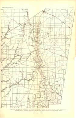
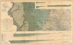
- Subject:
- Geographic Subject: Putnam County (Ind.), Geographic Subject: Benton County (Ind.), Geographic Subject: Fountain County (Ind.), Geographic Subject: Newton Co...
- Creator:
- Ashley, Geo. H. (George Hall), 1866-1951, Siebenthal, C. E. (Claude Ellsworth), 1869-1930, and Kindle, E. M. (Edward Martin), 1869-1940
- Publisher:
- Indiana. Department of Geology and Natural Resources
- Date Created:
- 1899
- Identifier:
- VAC3073-M-00270
- Genre:
- Geological cross-sections and Geological maps
- Geographic Location:
- Coordinates: W0873200 W0865200 N0403000 N0393600
- Related URL:
- Catalog URL: https://iucat.iu.edu/catalog/18265361
- Abstract:
- Relief shown by spot heights. Includes map showing coal locations and features, railroads, and quarries as well as two inset maps for parts of Newton and Ben...
- Call Number:
- G4093.W3H9 1898 .A84
- Caption:
- Imprint: Indianapolis, Ind. : Wm. B. Burford, [1899]
- Physical Description:
- Dimensions: 79 x 48 cm and Scale: Approximately 1:126,720. 2 miles = 1 inch
- Alternate Identifier:
- Alternate ID: 390726IP and Title Control Number: a18265361
- Persistent URL:
- https://purl.dlib.indiana.edu/iudl/images/VAC3073/VAC3073-M-00270
- Provenance:
- 23rd Annual Report (1898) / Indiana. Department of Geology and Natural Resources.
-

- Subject:
- Geographic Subject: Clay County (Ind.), Topical Subject: Coal, Geographic Subject: Putnam County (Ind.), Topical Subject: IGS Annual Reports, Geographic Subj...
- Creator:
- Ashley, Geo. H. (George Hall), 1866-1951, Siebenthal, C. E. (Claude Ellsworth), 1869-1930, and Scovell, J. T. (Josiah Thomas), 1841-
- Publisher:
- Indiana. Department of Geology and Natural Resources
- Date Created:
- 1899
- Identifier:
- VAC3073-M-00899
- Genre:
- Geological maps and Geological cross-sections
- Geographic Location:
- Coordinates: W0873635 W0864028 N0393634 N0390856
- Related URL:
- Catalog URL: https://iucat.iu.edu/catalog/18259650
- Abstract:
- Relief shown by spot heights. Includes map showing coal locations and features, railroads, and quarries as well as vertical cross sections for Dana to Portla...
- Call Number:
- G4093.V5H9 1898 .A84
- Caption:
- Imprint: Indianapolis, Ind. : Wm. B. Burford, [1899]
- Physical Description:
- Scale: Approximately 1:126,720. 2 miles = 1 inch and Dimensions: 48 x 77 cm
- Alternate Identifier:
- Alternate ID: 390726IP and Title Control Number: a18259650
- Persistent URL:
- https://purl.dlib.indiana.edu/iudl/images/VAC3073/VAC3073-M-00899
- Provenance:
- 23rd Annual Report (1898) / Indiana. Department of Geology and Natural Resources.
-
- Subject:
- Geographic Subject: Sullivan County (Ind.), Geographic Subject: Greene County (Ind.), Topical Subject: Geology, Topical Subject: Coal, and Topical Subject: I...
- Creator:
- Ashley, Geo. H. (George Hall), 1866-1951 and Siebenthal, C. E. (Claude Ellsworth), 1869-1930
- Publisher:
- Indiana. Department of Geology and Natural Resources
- Date Created:
- 1899
- Identifier:
- VAC3073-M-00945
- Genre:
- Geological cross-sections and Geological maps
- Geographic Location:
- Coordinates: W0873900 W0864200 N0391530 N0385400
- Related URL:
- Catalog URL: https://iucat.iu.edu/catalog/18265344
- Abstract:
- Relief shown by spot heights. Includes map showing the location of coal locations, coal features, and railroads, as well as geological cross sections for sev...
- Call Number:
- G4093.S8H9 1898 .A84
- Caption:
- Imprint: Indianapolis, Ind. : Wm. B. Burford, [1899]
- Physical Description:
- Scale: Approximately 1:126,720. 2 miles = 1 inch. Vertical scale approximately 1:4,800. 1 inch = 400 feet and Dimensions: 48 x 78 cm
- Alternate Identifier:
- Alternate ID: 390726IP and Title Control Number: a18265344
- Persistent URL:
- https://purl.dlib.indiana.edu/iudl/images/VAC3073/VAC3073-M-00945
- Provenance:
- 23rd Annual Report (1898) / Indiana. Department of Geology and Natural Resources.
-
- Subject:
- Geographic Subject: Knox County (Ind.), Geographic Subject: Martin County (Ind.), Topical Subject: Geology, Geographic Subject: Daviess County (Ind.), Geogra...
- Creator:
- Ashley, Geo. H. (George Hall), 1866-1951
- Publisher:
- Indiana. Department of Geology and Natural Resources
- Date Created:
- 1899
- Identifier:
- VAC3073-M-00020
- Genre:
- Geological maps and Geological cross-sections
- Geographic Location:
- Coordinates: W0874543 W0863835 N0385428 N0382402
- Related URL:
- Catalog URL: https://iucat.iu.edu/catalog/18272877
- Abstract:
- Relief shown by spot heights. Includes map showing coal locations and features, railroads, and quarries as well as a vertical cross section along the B. &...
- Call Number:
- G4093.K5H9 1898 .A84
- Caption:
- Imprint: Indianapolis : Wm. B. Burford, [1899]
- Physical Description:
- Dimensions: 48 x 78 cm and Scale: Approximately 1:126,720. 2 miles = 1 inch
- Alternate Identifier:
- Alternate ID: 390726IP and Title Control Number: a18272877
- Persistent URL:
- https://purl.dlib.indiana.edu/iudl/images/VAC3073/VAC3073-M-00020
- Provenance:
- 23rd Annual Report (1898) / Indiana. Department of Geology and Natural Resources.
-

- Subject:
- Geographic Subject: Crawford County (Ind.), Topical Subject: IGS Annual Reports, Geographic Subject: Dubois County (Ind.), Geographic Subject: Pike County (I...
- Creator:
- Kindle, E. M. (Edward Martin), 1869-1940, Price, J. A., and Ashley, Geo. H. (George Hall), 1866-1951
- Publisher:
- Indiana. Department of Geology and Natural Resources
- Date Created:
- 1899
- Identifier:
- VAC3073-M-00944
- Genre:
- Geological maps and Geological cross-sections
- Geographic Location:
- Coordinates: W0872700 W0862700 N0384200 N0381200
- Related URL:
- Catalog URL: https://iucat.iu.edu/catalog/18175917
- Abstract:
- Relief shown by spot heights. Includes map showing coal locations and features, and quarries as well as vertical cross-sections through center of Township 3 ...
- Call Number:
- G4093.P4H9 1898 .A84
- Caption:
- Imprint: Indianapolis : Burford, [1899]
- Physical Description:
- Dimensions: 48 x 78 cm and Scale: Approximately 1:126,720. 1 inch = 2 miles. Vertical scale approximately 1:4,800. 1 inch = 400 feet
- Alternate Identifier:
- Title Control Number: a18175917 and Alternate ID: 390726IP
- Persistent URL:
- https://purl.dlib.indiana.edu/iudl/images/VAC3073/VAC3073-M-00944
- Provenance:
- 23rd Annual Report (1898) / Indiana. Department of Geology and Natural Resources.
-
- Subject:
- Geographic Subject: Warrick County (Ind.), Geographic Subject: Spencer County (Ind.), Topical Subject: Geology, Topical Subject: IGS Annual Reports, Geograph...
- Creator:
- Ashley, Geo. H. (George Hall), 1866-1951, Price, J. A., and Kindle, E. M. (Edward Martin), 1869-1940
- Publisher:
- Indiana. Department of Geology and Natural Resources
- Date Created:
- 1899
- Identifier:
- VAC3073-M-00931
- Genre:
- Geological cross-sections and Geological maps
- Geographic Location:
- Coordinates: W0872823 W0862942 N0381446 N0374639
- Related URL:
- Catalog URL: https://iucat.iu.edu/catalog/16848969
- Abstract:
- Relief shown by profile. Shows two geological cross-sections. "Based upon Congressional land surveys, field work of Ind. Geol. Survey, county atlases.&q...
- Call Number:
- G4093.W4H9 1898 .A8x
- Caption:
- Imprint: Indianapolis : Burford, [1899] and Imprint: [Indianapolis, Ind.] : Dept. of Geology and Natural Resources of Indiana, [1899]
- Physical Description:
- Scale: Approximately 1:126,720. 2 miles = 1 inch. Vertical scale approximately 1:4,800. 400 feet = 1 inch and Dimensions: 49 x 77 cm
- Alternate Identifier:
- Alternate ID: 390726IP and Title Control Number: a16848969
- Persistent URL:
- https://purl.dlib.indiana.edu/iudl/images/VAC3073/VAC3073-M-00931
- Provenance:
- 23rd Annual Report (1898) / Indiana. Department of Geology and Natural Resources.
-
- Subject:
- Geographic Subject: Posey County (Ind.), Geographic Subject: Gibson County (Ind.), Geographic Subject: Indiana, Topical Subject: Coal, Topical Subject: Geolo...
- Creator:
- Ashley, Mary Martin and Ashley, Geo. H. (George Hall), 1866-1951
- Publisher:
- Indiana. Department of Geology and Natural Resources
- Date Created:
- 1899
- Identifier:
- VAC3073-M-00927
- Genre:
- Geological maps
- Geographic Location:
- Coordinates: W0880600 W0872700 N0383300 N0374500
- Related URL:
- Catalog URL: https://iucat.iu.edu/catalog/18188198
- Abstract:
- Relief shown by spot heights. "Based upon[:] B. F. & Co.'s Atlas of Indiana, 1876. Lake's Atlas of Gibson and Pike Counties, 1881. F. C. H. ...
- Call Number:
- QE109 .A2 1898 map p1408
- Caption:
- Imprint: Indianapolis, Ind. : Wm. B. Burford, [1899]
- Physical Description:
- Scale: Approximately 1:126,720. 2 miles = 1 inch and Dimensions: 78 x 48 cm
- Alternate Identifier:
- Title Control Number: a18188198 and Alternate ID: 390726IP
- Persistent URL:
- https://purl.dlib.indiana.edu/iudl/images/VAC3073/VAC3073-M-00927
- Provenance:
- 23rd Annual Report (1898) / Indiana. Department of Geology and Natural Resources.
-
- Subject:
- Geographic Subject: Warren County (Ind.), Topical Subject: IGS Annual Reports, Geographic Subject: Vermillion County (Ind.), Geographic Subject: Attica (Ind....
- Creator:
- Hopkins, Thomas Cramer, 1861-1935
- Publisher:
- Indiana. Department of Geology and Natural Resources
- Date Created:
- 1896
- Identifier:
- VAC3073-M-01063
- Genre:
- Geological maps
- Geographic Location:
- Coordinates: W0872852 W0870229 N0402834 N0395753
- Related URL:
- Catalog URL: https://iucat.iu.edu/catalog/17228652
- Abstract:
- Detached from: The carboniferous sandstones of western Indiana / T.C. Hopkins. In Indiana Dept. of Geology and Natural Resources twentieth annual report. Ind...
- Call Number:
- G4094.A6C5 1895 .G4
- Caption:
- Imprint: Indianapolis : Wm. B. Burford, 1896.
- Physical Description:
- Scale: Approximately 1:126,720. 2 miles = 1 inch and Dimensions: 47 x 32 cm
- Alternate Identifier:
- Alternate ID: 390726IP and Title Control Number: a17228652
- Persistent URL:
- https://purl.dlib.indiana.edu/iudl/images/VAC3073/VAC3073-M-01063
- Provenance:
- 20th Annual Report (1895) / Indiana. Department of Geology and Natural Resources.
-
- Subject:
- Topical Subject: IGS Annual Reports, Topical Subject: Geology, Geographic Subject: Clay County (Ind.), Geographic Subject: Brazil (Ind.), Geographic Subject:...
- Creator:
- Hopkins, Thomas Cramer, 1861-1935
- Publisher:
- Indiana. Department of Geology and Natural Resources
- Date Created:
- 1896
- Identifier:
- VAC3073-M-01062
- Genre:
- Geological maps
- Geographic Location:
- Coordinates: W0871800 W0864800 N0395700 N0392500
- Related URL:
- Catalog URL: https://iucat.iu.edu/catalog/18175494
- Abstract:
- Detached from: The carboniferous sandstones of western Indiana / T.C. Hopkins. In Indiana Dept. of Geology and Natural Resources twentieth annual report. Ind...
- Call Number:
- G4094.B7C5 1895 .G4
- Caption:
- Imprint: Indianapolis : Wm. B. Burford, 1896.
- Physical Description:
- Dimensions: 53 x 38 cm and Scale: Approximately 1:126,720. 2 miles = 1 inch
- Alternate Identifier:
- Title Control Number: a18175494 and Alternate ID: 390726IP
- Persistent URL:
- https://purl.dlib.indiana.edu/iudl/images/VAC3073/VAC3073-M-01062
- Provenance:
- 20th Annual Report (1895) / Indiana. Department of Geology and Natural Resources.
-
- Subject:
- Topical Subject: IGS Annual Reports, Topical Subject: Mines and mineral resources, Topical Subject: Church buildings, Topical Subject: Geology, and Geographi...
- Creator:
- Kindle, E. M. (Edward Martin), 1869-1940
- Publisher:
- Indiana. Department of Geology and Natural Resources
- Date Created:
- 1896
- Identifier:
- VAC3073-M-01061
- Genre:
- Geological maps
- Geographic Location:
- Coordinates: W0864800 W0862700 N0384100 N0382400
- Related URL:
- Catalog URL: https://iucat.iu.edu/catalog/18175514
- Abstract:
- Shows the locations of coal, sandstone, and limestone areas as well as the locations of quarries, coal mines, and churches. Detached from: The carbonifero...
- Call Number:
- G4093.O6H1 1895 .K56
- Caption:
- Imprint: Indianapolis, Ind. : Wm. B. Burford, Lith., 1896
- Physical Description:
- Scale: Approximately 1:126,720. 2 miles = 1 inch and Dimensions: 33 x 27 cm
- Alternate Identifier:
- Title Control Number: a18175514 and Alternate ID: 390726IP
- Persistent URL:
- https://purl.dlib.indiana.edu/iudl/images/VAC3073/VAC3073-M-01061
- Provenance:
- 20th Annual Report (1895) / Indiana. Department of Geology and Natural Resources.
-
- Subject:
- Geographic Subject: Franklin County (Ind.), Topical Subject: Geology, Topical Subject: IGS Annual Reports, and Geographic Subject: Decatur County (Ind.)
- Creator:
- Foerste, Aug. F. (Aug. Frederic), 1862-1936
- Publisher:
- Indiana. Department of Geology and Natural Resources
- Date Created:
- 1898
- Identifier:
- VAC3073-M-00631
- Genre:
- Geological maps
- Geographic Location:
- Coordinates: W0852152 W0850747 N0393129 N0391606
- Related URL:
- Catalog URL: https://iucat.iu.edu/catalog/17227850
- Abstract:
- Plate XVII. "Report of State Geologist, 1897, plate xvii." Detached from: A report on the Niagara limestone quarries of Decatur, Franklin and...
- Call Number:
- G4093.F7C5 1897 .F64
- Caption:
- Imprint: [Indianapolis] : [Wm. B. Burford], [1898] and Imprint: [Indianapolis] : [Indiana Department of Geology and Natural Resources], [1898]
- Physical Description:
- Scale: Approximately 1:126,720. 2 miles = 1 inch and Dimensions: 25 x 15 cm
- Alternate Identifier:
- Title Control Number: a17227850 and Alternate ID: 390726IP
- Persistent URL:
- https://purl.dlib.indiana.edu/iudl/images/VAC3073/VAC3073-M-00631
- Provenance:
- 22nd Annual Report (1897) / Indiana. Department of Geology and Natural Resources.
-
- Subject:
- Geographic Subject: Scott County (Ind.), Topical Subject: Limestone, Topical Subject: IGS Annual Reports, Topical Subject: Geology, Geographic Subject: Clark...
- Creator:
- Siebenthal, C. E. (Claude Ellsworth), 1869-1930
- Publisher:
- Indiana. Department of Geology and Natural Resources
- Date Created:
- 1901
- Identifier:
- VAC3073-M-00893
- Genre:
- Geological maps
- Geographic Location:
- Coordinates: W0855100 W0852100 N0384500 N0381530
- Related URL:
- Catalog URL: https://iucat.iu.edu/catalog/18188442
- Abstract:
- "NOTE - The eastern outcrop of the Knobstone is from map by Ind. Univ. Geol. Surv. Eastern outcrop of Devonian surveyed by J. A. Price. Eastern outcrop ...
- Call Number:
- G4091.H5 1900 .S54
- Caption:
- Imprint: Indianapolis, Ind. : Wm. B. Burford, Lith., [1901]
- Physical Description:
- Scale: Approximately 1:126,720. 2 miles = 1 inch and Dimensions: 47 x 38 cm
- Alternate Identifier:
- Title Control Number: a18188442 and Alternate ID: 390726IP
- Persistent URL:
- https://purl.dlib.indiana.edu/iudl/images/VAC3073/VAC3073-M-00893
- Provenance:
- 25th Annual Report (1900) / Indiana. Department of Geology and Natural Resources.
-
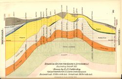
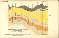
- Subject:
- Topical Subject: Mines and mineral resources, Geographic Subject: Indiana, Topical Subject: Geology, Stratigraphic, and Topical Subject: IGS Annual Reports
- Creator:
- Cubberley, Ellwood P., 1868-1941
- Publisher:
- Indiana. Department of Geology and Natural Resources
- Date Created:
- 1894
- Identifier:
- VAC3073-M-01556
- Genre:
- Geological cross-sections
- Geographic Location:
- Coordinates: W0854600 W0845600 N0414500 N0381500
- Related URL:
- Catalog URL: https://iucat.iu.edu/catalog/18174983
- Abstract:
- Relief shown by profile. Geological cross section showing stratigraphy of mineral resources, including various limestone and shale layers. See "Map show...
- Call Number:
- G4091.C57 1893 .C83, no. 13
- Caption:
- Imprint: [Indianapolis] : [Indiana, Dept. of Geology and Natural Resources], [1894] and Imprint: Indpls : lithographed by William B. Burford, [1894]
- Physical Description:
- Scale: Approximately 1:1,900,800. 30 miles to the inch. Vertical scale approximately 1:6,000. 500 feet to the inch and Dimensions: 15 x 23 cm
- Alternate Identifier:
- Title Control Number: a18174983 and Alternate ID: 390726IP
- Persistent URL:
- https://purl.dlib.indiana.edu/iudl/images/VAC3073/VAC3073-M-01556
- Provenance:
- 18th Annual Report (1893) / Indiana. Department of Geology and Natural Resources.
-
- Subject:
- Topical Subject: Mines and mineral resources, Topical Subject: Geology, Stratigraphic, Topical Subject: IGS Annual Reports, and Geographic Subject: Indiana
- Creator:
- Cubberley, Ellwood P., 1868-1941
- Publisher:
- Indiana. Department of Geology and Natural Resources
- Date Created:
- 1894
- Identifier:
- VAC3073-M-01557
- Genre:
- Geological cross-sections
- Geographic Location:
- Coordinates: W0873400 W0844600 N0405100 N0383900
- Related URL:
- Catalog URL: https://iucat.iu.edu/catalog/18175091
- Abstract:
- Geological cross section showing stratigraphy of mineral resources, including various limestone and shale layers. Relative relief in relation to sea level sh...
- Call Number:
- G4091.C57 1893 .C83, no. 2
- Caption:
- Imprint: Indpls : lithographed by William B. Burford, [1894] and Imprint: [Indianapolis] : [Indiana, Dept. of Geology and Natural Resources], [1894]
- Physical Description:
- Scale: Approximately 1:1,900,800. 30 miles to the inch. Vertical scale approximately 1:6,000. 500 feet to the inch and Dimensions: 15 x 23 cm
- Alternate Identifier:
- Title Control Number: a18175091 and Alternate ID: 390726IP
- Persistent URL:
- https://purl.dlib.indiana.edu/iudl/images/VAC3073/VAC3073-M-01557
- Provenance:
- 18th Annual Report (1893) / Indiana. Department of Geology and Natural Resources.
-
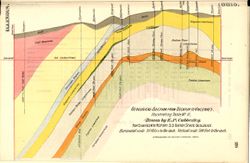
- Subject:
- Geographic Subject: Indiana, Topical Subject: Mines and mineral resources, Topical Subject: Geology, Stratigraphic, Topical Subject: IGS Annual Reports, and ...
- Creator:
- Cubberley, Ellwood P., 1868-1941
- Publisher:
- Indiana. Department of Geology and Natural Resources
- Date Created:
- 1894
- Identifier:
- VAC3073-M-01558
- Genre:
- Geological cross-sections
- Geographic Location:
- Coordinates: W0873300 W0835800 N0413500 N0392600
- Related URL:
- Catalog URL: https://iucat.iu.edu/catalog/18175093
- Abstract:
- Geological cross section showing stratigraphy of mineral resources, including various limestone and shale layers. Relative relief in relation to sea level sh...
- Call Number:
- G4091.C57 1893 .C83, no. 1
- Caption:
- Imprint: Indpls : lithographed by William B. Burford, [1894] and Imprint: [Indianapolis] : [Indiana, Dept. of Geology and Natural Resources], [1894]
- Physical Description:
- Scale: Approximately 1:1,900,800. 30 miles to the inch. Vertical scale approximately 1:6,000. 500 feet to the inch and Dimensions: 15 x 23 cm
- Alternate Identifier:
- Alternate ID: 390726IP and Title Control Number: a18175093
- Persistent URL:
- https://purl.dlib.indiana.edu/iudl/images/VAC3073/VAC3073-M-01558
- Provenance:
- 18th Annual Report (1893) / Indiana. Department of Geology and Natural Resources.
-
- Subject:
- Topical Subject: Geology, Stratigraphic, Geographic Subject: Indiana, Topical Subject: Mines and mineral resources, and Topical Subject: IGS Annual Reports
- Creator:
- Cubberley, Ellwood P., 1868-1941
- Publisher:
- Indiana. Department of Geology and Natural Resources
- Date Created:
- 1894
- Identifier:
- VAC3073-M-01559
- Genre:
- Geological cross-sections
- Geographic Location:
- Coordinates: W0873300 W0844700 N0405000 N0404400
- Related URL:
- Catalog URL: https://iucat.iu.edu/catalog/18175184
- Abstract:
- Geological cross section showing stratigraphy of mineral resources, including various limestone and shale layers. Relative relief in relation to sea level sh...
- Call Number:
- G4091.C57 1893 .C83, no. 8
- Caption:
- Imprint: Indpls : lithographed by William B. Burford, [1894] and Imprint: [Indianapolis] : [Indiana, Dept. of Geology and Natural Resources], [1894]
- Physical Description:
- Scale: Approximately 1:1,900,800. 30 miles to the inch. Vertical scale approximately 1:6,000. 500 feet to the inch and Dimensions: 15 x 23 cm
- Alternate Identifier:
- Alternate ID: 390726IP and Title Control Number: a18175184
- Persistent URL:
- https://purl.dlib.indiana.edu/iudl/images/VAC3073/VAC3073-M-01559
- Provenance:
- 18th Annual Report (1893) / Indiana. Department of Geology and Natural Resources.
-
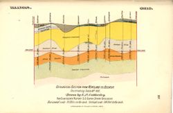
- Subject:
- Topical Subject: Geology, Stratigraphic, Geographic Subject: Indiana, Geographic Subject: Ohio, Topical Subject: Mines and mineral resources, and Topical Sub...
- Creator:
- Cubberley, Ellwood P., 1868-1941
- Publisher:
- Indiana. Department of Geology and Natural Resources
- Date Created:
- 1894
- Identifier:
- VAC3073-M-01560
- Genre:
- Geological cross-sections
- Geographic Location:
- Coordinates: W0873100 W0835800 N0413500 N0404200
- Related URL:
- Catalog URL: https://iucat.iu.edu/catalog/18188874
- Abstract:
- Geological cross section showing stratigraphy of mineral resources, including various limestone and shale layers. Relative relief in relation to sea level sh...
- Call Number:
- G4091.C57 1893 .C83, no. 7
- Caption:
- Imprint: Indpls : lithographed by William B. Burford, [1894] and Imprint: [Indianapolis] : [Indiana, Dept. of Geology and Natural Resources], [1894]
- Physical Description:
- Dimensions: 15 x 23 cm and Scale: Approximately 1:1,900,800. 30 miles to the inch. Vertical scale approximately 1:6,000. 500 feet to the inch
- Alternate Identifier:
- Title Control Number: a18188874 and Alternate ID: 390726IP
- Persistent URL:
- https://purl.dlib.indiana.edu/iudl/images/VAC3073/VAC3073-M-01560
- Provenance:
- 18th Annual Report (1893) / Indiana. Department of Geology and Natural Resources.
-
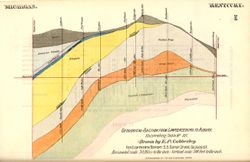
- Subject:
- Topical Subject: IGS Annual Reports, Geographic Subject: Indiana, Topical Subject: Geology, Stratigraphic, and Topical Subject: Mines and mineral resources
- Creator:
- Cubberley, Ellwood P., 1868-1941
- Publisher:
- Indiana. Department of Geology and Natural Resources
- Date Created:
- 1894
- Identifier:
- VAC3073-M-01561
- Genre:
- Geological cross-sections
- Geographic Location:
- Coordinates: W0850606 W0844724 N0414550 N0390449
- Related URL:
- Catalog URL: https://iucat.iu.edu/catalog/18188961
- Abstract:
- Geological cross section showing stratigraphy of mineral resources, including various limestone and shale layers. Relative relief in relation to sea level sh...
- Call Number:
- G4091.C57 1893 .C83, no. 12
- Caption:
- Imprint: Indpls : lithographed by William B. Burford, [1894] and Imprint: [Indianapolis] : [Indiana, Dept. of Geology and Natural Resources], [1894]
- Physical Description:
- Scale: Approximately 1:1,900,800. 30 miles to the inch. Vertical scale approximately 1:6,000. 500 feet to the inch and Dimensions: 15 x 23 cm
- Alternate Identifier:
- Title Control Number: a18188961 and Alternate ID: 390726IP
- Persistent URL:
- https://purl.dlib.indiana.edu/iudl/images/VAC3073/VAC3073-M-01561
- Provenance:
- 18th Annual Report (1893) / Indiana. Department of Geology and Natural Resources.
-
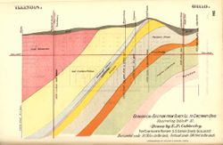
- Subject:
- Geographic Subject: Ohio, Geographic Subject: Indiana, Topical Subject: IGS Annual Reports, Topical Subject: Geology, Stratigraphic, Topical Subject: Mines a...
- Creator:
- Cubberley, Ellwood P., 1868-1941
- Publisher:
- Indiana. Department of Geology and Natural Resources
- Date Created:
- 1894
- Identifier:
- VAC3073-M-01562
- Genre:
- Geological cross-sections
- Geographic Location:
- Coordinates: W0880700 W0842800 N0390700 N0384100
- Related URL:
- Catalog URL: https://iucat.iu.edu/catalog/18188969
- Abstract:
- Geological cross section showing stratigraphy of mineral resources, including various coal, limestone, and shale layers. Relative relief in relation to sea l...
- Call Number:
- QE109 .A2
- Caption:
- Imprint: [Indianapolis] : [Indiana, Dept. of Geology and Natural Resources], [1894] and Imprint: Indpls : lithographed by William B. Burford, [1894]
- Physical Description:
- Scale: Approximately 1:1,900,800. 30 miles to the inch. Vertical scale approximately 1:6,000. 500 feet to the inch and Dimensions: 15 x 23 cm
- Alternate Identifier:
- Title Control Number: a18188969 and Alternate ID: 390726IP
- Persistent URL:
- https://purl.dlib.indiana.edu/iudl/images/VAC3073/VAC3073-M-01562
- Provenance:
- 18th Annual Report (1893) / Indiana. Department of Geology and Natural Resources.
-
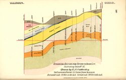
- Subject:
- Topical Subject: Mines and mineral resources, Topical Subject: Geology, Stratigraphic, Topical Subject: IGS Annual Reports, and Geographic Subject: Indiana
- Creator:
- Cubberley, Ellwood P., 1868-1941
- Publisher:
- Indiana. Department of Geology and Natural Resources
- Date Created:
- 1894
- Identifier:
- VAC3073-M-01563
- Genre:
- Geological cross-sections
- Geographic Location:
- Coordinates: W0873148 W0844819 N0403259 N0401126
- Related URL:
- Catalog URL: https://iucat.iu.edu/catalog/18188985
- Abstract:
- Geological cross section showing stratigraphy of mineral resources, including various coal, limestone, and shale layers. Relative relief in relation to sea l...
- Call Number:
- G4091.C57 1893 .C83, no. 9
- Caption:
- Imprint: Indpls : lithographed by William B. Burford, [1894] and Imprint: [Indianapolis] : [Indiana, Dept. of Geology and Natural Resources], [1894]
- Physical Description:
- Dimensions: 15 x 23 cm and Scale: Approximately 1:1,900,800. 30 miles to the inch. Vertical scale approximately 1:6,000. 500 feet to the inch
- Alternate Identifier:
- Title Control Number: a18188985 and Alternate ID: 390726IP
- Persistent URL:
- https://purl.dlib.indiana.edu/iudl/images/VAC3073/VAC3073-M-01563
- Provenance:
- 18th Annual Report (1893) / Indiana. Department of Geology and Natural Resources.
-
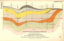
- Subject:
- Topical Subject: Mines and mineral resources, Geographic Subject: Indiana, Geographic Subject: Kentucky, Topical Subject: Geology, Stratigraphic, and Topical...
- Creator:
- Cubberley, Ellwood P., 1868-1941
- Publisher:
- Indiana. Department of Geology and Natural Resources
- Date Created:
- 1894
- Identifier:
- VAC3073-M-01564
- Genre:
- Geological cross-sections
- Geographic Location:
- Coordinates: W0873200 W0844900 N0404600 N0381000
- Related URL:
- Catalog URL: https://iucat.iu.edu/catalog/18189045
- Abstract:
- Geological cross section showing stratigraphy of mineral resources, including various limestone and shale layers. Relative relief in relation to sea level sh...
- Call Number:
- G4091.C57 1893 .C83, no. 6
- Caption:
- Imprint: [Indianapolis] : [Indiana, Dept. of Geology and Natural Resources], [1894] and Imprint: Indpls : lithographed by William B. Burford, [1894]
- Physical Description:
- Dimensions: 15 x 23 cm and Scale: Approximately 1:1,900,800. 30 miles to the inch. Vertical scale approximately 1:6,000. 500 feet to the inch
- Alternate Identifier:
- Title Control Number: a18189045 and Alternate ID: 390726IP
- Persistent URL:
- https://purl.dlib.indiana.edu/iudl/images/VAC3073/VAC3073-M-01564
- Provenance:
- 18th Annual Report (1893) / Indiana. Department of Geology and Natural Resources.
-
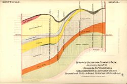
- Subject:
- Topical Subject: Mines and mineral resources, Topical Subject: IGS Annual Reports, Geographic Subject: Indiana, and Topical Subject: Geology, Stratigraphic
- Creator:
- Cubberley, Ellwood P., 1868-1941
- Publisher:
- Indiana. Department of Geology and Natural Resources
- Date Created:
- 1894
- Identifier:
- VAC3073-M-01565
- Genre:
- Geological cross-sections
- Geographic Location:
- Coordinates: W0860745 W0844830 N0395315 N0375945
- Related URL:
- Catalog URL: https://iucat.iu.edu/catalog/18224846
- Abstract:
- Geological cross section showing stratigraphy of mineral resources, including various coal, limestone, and shale layers. Relative relief in relation to sea l...
- Call Number:
- G4091.C57 1893 .C83, no. 3
- Caption:
- Imprint: [Indianapolis] : [Indiana, Dept. of Geology and Natural Resources], [1894] and Imprint: Indpls : lithographed by William B. Burford, [1894]
- Physical Description:
- Scale: Approximately 1:1,900,800. 30 miles to the inch. Vertical scale approximately 1:6,000. 500 feet to the inch and Dimensions: 15 x 23 cm
- Alternate Identifier:
- Alternate ID: 390726IP and Title Control Number: a18224846
- Persistent URL:
- https://purl.dlib.indiana.edu/iudl/images/VAC3073/VAC3073-M-01565
- Provenance:
- 18th Annual Report (1893) / Indiana. Department of Geology and Natural Resources.
-
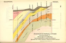
- Subject:
- Topical Subject: Geology, Stratigraphic, Topical Subject: Mines and mineral resources, Topical Subject: IGS Annual Reports, and Geographic Subject: Indiana
- Creator:
- Cubberley, Ellwood P., 1868-1941
- Publisher:
- Indiana. Department of Geology and Natural Resources
- Date Created:
- 1894
- Identifier:
- VAC3073-M-01566
- Genre:
- Geological cross-sections
- Geographic Location:
- Coordinates: W0873200 W0844900 N0395000 N0394500
- Related URL:
- Catalog URL: https://iucat.iu.edu/catalog/18224850
- Abstract:
- Geological cross section showing stratigraphy of mineral resources, including various coal, limestone, and shale layers. Relative relief in relation to sea l...
- Call Number:
- G4091.C57 1893 .C83, no. 10
- Caption:
- Imprint: Indpls : lithographed by William B. Burford, [1894] and Imprint: [Indianapolis] : [Indiana, Dept. of Geology and Natural Resources], [1894]
- Physical Description:
- Scale: Approximately 1:1,900,800. 30 miles to the inch. Vertical scale approximately 1:6,000. 500 feet to the inch and Dimensions: 15 x 23 cm
- Alternate Identifier:
- Title Control Number: a18224850 and Alternate ID: 390726IP
- Persistent URL:
- https://purl.dlib.indiana.edu/iudl/images/VAC3073/VAC3073-M-01566
- Provenance:
- 18th Annual Report (1893) / Indiana. Department of Geology and Natural Resources.
-
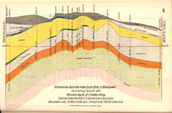
- Subject:
- Topical Subject: Geology, Stratigraphic, Geographic Subject: Indiana, Topical Subject: Mines and mineral resources, and Topical Subject: IGS Annual Reports
- Creator:
- Cubberley, Ellwood P., 1868-1941
- Publisher:
- Indiana. Department of Geology and Natural Resources
- Date Created:
- 1894
- Identifier:
- VAC3073-M-01567
- Genre:
- Geological cross-sections
- Geographic Location:
- Coordinates: W0861818 W0854806 N0414542 N0381622
- Related URL:
- Catalog URL: https://iucat.iu.edu/catalog/18224912
- Abstract:
- Geological cross section showing stratigraphy of mineral resources, including various limestone and shale layers. Relative relief in relation to sea level sh...
- Call Number:
- G4091.C57 1893 .C83, no. 14
- Caption:
- Imprint: [Indianapolis] : [Indiana, Dept. of Geology and Natural Resources], [1894] and Imprint: Indpls : lithographed by William B. Burford, [1894]
- Physical Description:
- Dimensions: 15 x 23 cm and Scale: Approximately 1:1,900,800. 30 miles to the inch. Vertical scale approximately 1:6,000. 500 feet to the inch
- Alternate Identifier:
- Title Control Number: a18224912 and Alternate ID: 390726IP
- Persistent URL:
- https://purl.dlib.indiana.edu/iudl/images/VAC3073/VAC3073-M-01567
- Provenance:
- 18th Annual Report (1893) / Indiana. Department of Geology and Natural Resources.
-
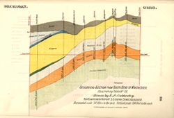
- Subject:
- Topical Subject: IGS Annual Reports, Topical Subject: Mines and mineral resources, Geographic Subject: Indiana, and Topical Subject: Geology, Stratigraphic
- Creator:
- Cubberley, Ellwood P., 1868-1941
- Publisher:
- Indiana. Department of Geology and Natural Resources
- Date Created:
- 1894
- Identifier:
- VAC3073-M-01568
- Genre:
- Geological cross-sections
- Geographic Location:
- Coordinates: W0862100 W0844815 N0414545 N0400900
- Related URL:
- Catalog URL: https://iucat.iu.edu/catalog/18224917
- Abstract:
- Geological cross section showing stratigraphy of mineral resources, including various limestone and shale layers. Relative relief in relation to sea level sh...
- Call Number:
- G4091.C57 1893 .C83, no. 4
- Caption:
- Imprint: [Indianapolis] : [Indiana, Dept. of Geology and Natural Resources], [1894] and Imprint: Indpls : lithographed by William B. Burford, [1894]
- Physical Description:
- Scale: Approximately 1:1,900,800. 30 miles to the inch. Vertical scale approximately 1:6,000. 500 feet to the inch and Dimensions: 15 x 23 cm
- Alternate Identifier:
- Alternate ID: 390726IP and Title Control Number: a18224917
- Persistent URL:
- https://purl.dlib.indiana.edu/iudl/images/VAC3073/VAC3073-M-01568
- Provenance:
- 18th Annual Report (1893) / Indiana. Department of Geology and Natural Resources.
-
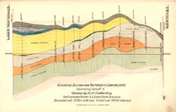
- Subject:
- Geographic Subject: Indiana, Topical Subject: Mines and mineral resources, Topical Subject: Geology, Stratigraphic, and Topical Subject: IGS Annual Reports
- Creator:
- Cubberley, Ellwood P., 1868-1941
- Publisher:
- Indiana. Department of Geology and Natural Resources
- Date Created:
- 1894
- Identifier:
- VAC3073-M-01569
- Genre:
- Geological cross-sections
- Geographic Location:
- Coordinates: W0870605 W0845021 N0413930 N0390428
- Related URL:
- Catalog URL: https://iucat.iu.edu/catalog/18224921
- Abstract:
- Geological cross section showing stratigraphy of mineral resources, including various limestone and shale layers. Relative relief in relation to sea level sh...
- Call Number:
- G4091.C57 1893 .C83, no. 5
- Caption:
- Imprint: Indpls : lithographed by William B. Burford, [1894] and Imprint: [Indianapolis] : [Indiana, Dept. of Geology and Natural Resources], [1894]
- Physical Description:
- Scale: Approximately 1:1,900,800. 30 miles to the inch. Vertical scale approximately 1:6,000. 500 feet to the inch and Dimensions: 15 x 23 cm
- Alternate Identifier:
- Title Control Number: a18224921 and Alternate ID: 390726IP
- Persistent URL:
- https://purl.dlib.indiana.edu/iudl/images/VAC3073/VAC3073-M-01569
- Provenance:
- 18th Annual Report (1893) / Indiana. Department of Geology and Natural Resources.
-
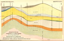
- Subject:
- Topical Subject: IGS Annual Reports, Geographic Subject: Indiana, Topical Subject: Geology, Stratigraphic, and Topical Subject: Mines and mineral resources
- Creator:
- Cubberley, Ellwood P., 1868-1941
- Publisher:
- Indiana. Department of Geology and Natural Resources
- Date Created:
- 1894
- Identifier:
- VAC3073-M-01570
- Genre:
- Geological cross-sections
- Geographic Location:
- Coordinates: W0870500 W0860300 N0414000 N0380000
- Related URL:
- Catalog URL: https://iucat.iu.edu/catalog/18224924
- Abstract:
- Geological cross section showing stratigraphy of mineral resources, including various limestone and shale layers. Relative relief in relation to sea level sh...
- Call Number:
- G4091.C57 1893 .C83, no. 15
- Caption:
- Imprint: Indpls : lithographed by William B. Burford, [1894] and Imprint: [Indianapolis] : [Indiana, Dept. of Geology and Natural Resources], [1894]
- Physical Description:
- Scale: Approximately 1:1,900,800. 30 miles to the inch. Vertical scale approximately 1:6,000. 500 feet to the inch and Dimensions: 15 x 23 cm
- Alternate Identifier:
- Alternate ID: 390726IP and Title Control Number: a18224924
- Persistent URL:
- https://purl.dlib.indiana.edu/iudl/images/VAC3073/VAC3073-M-01570
- Provenance:
- 18th Annual Report (1893) / Indiana. Department of Geology and Natural Resources.
-
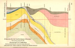
- Subject:
- Topical Subject: Mines and mineral resources, Geographic Subject: Indiana, Topical Subject: IGS Annual Reports, and Topical Subject: Geology, Stratigraphic
- Creator:
- Cubberley, Ellwood P., 1868-1941
- Publisher:
- Indiana. Department of Geology and Natural Resources
- Date Created:
- 1894
- Identifier:
- VAC3073-M-01571
- Genre:
- Geological cross-sections
- Geographic Location:
- Coordinates: W0873400 W0870100 N0414000 N0383900
- Related URL:
- Catalog URL: https://iucat.iu.edu/catalog/18224924
- Abstract:
- Geological cross section showing stratigraphy of mineral resources, including various coal, limestone, and shale layers. Relative relief in relation to sea l...
- Call Number:
- G4091.C57 1893 .C83, no. 16
- Caption:
- Imprint: Indpls : lithographed by William B. Burford, [1894] and Imprint: [Indianapolis] : [Indiana, Dept. of Geology and Natural Resources], [1894]
- Physical Description:
- Dimensions: 15 x 23 cm and Scale: Approximately 1:1,900,800. 30 miles to the inch. Vertical scale approximately 1:6,000. 500 feet to the inch
- Alternate Identifier:
- Alternate ID: 390726IP and Title Control Number: a18224924
- Persistent URL:
- https://purl.dlib.indiana.edu/iudl/images/VAC3073/VAC3073-M-01571
- Provenance:
- 18th Annual Report (1893) / Indiana. Department of Geology and Natural Resources.
-
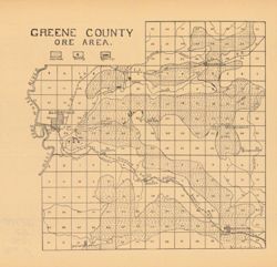
- Subject:
- Geographic Subject: Greene County (Ind.), Topical Subject: Iron ores, and Topical Subject: IGS Annual Reports
- Publisher:
- Indiana. Department of Geology and Natural Resources
- Date Created:
- 1907
- Identifier:
- VAC3073-M-00949
- Genre:
- Geological maps
- Geographic Location:
- Coordinates: W0871431 W0864053 N0391018 N0385418
- Related URL:
- Catalog URL: https://iucat.iu.edu/catalog/18299136
- Abstract:
- Detached from: The iron ore deposits of Indiana / Charles W. Shannon. In Indiana Dept. of Geology and Natural Resources thirty-first annual report, 1906. Ind...
- Call Number:
- G4093.G7H2 1907 .G7
- Caption:
- Imprint: [Indianapolis] : [Indiana Dept. of Geology and Natural Resources], [1907] and Imprint: [Indianapolis] : [Wm. B. Burford], [1907]
- Physical Description:
- Dimensions: on sheet 23 x 24 cm and Scale: Approximately 1:130,000
- Alternate Identifier:
- Alternate ID: 390726IP and Title Control Number: a18299136
- Persistent URL:
- https://purl.dlib.indiana.edu/iudl/images/VAC3073/VAC3073-M-00949
- Provenance:
- 31st Annual Report (1906) / Indiana. Department of Geology and Natural Resources.
-
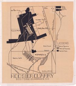
- Subject:
- Topical Subject: IGS Annual Reports, Topical Subject: Limestone industry, Geographic Subject: Oolitic (Ind.), and Topical Subject: Quarries and quarrying
- Publisher:
- Indiana. Department of Geology and Natural Resources
- Date Created:
- 1908
- Identifier:
- VAC3073-M-01068
- Genre:
- Mine maps
- Geographic Location:
- Coordinates: W0863200 W0863100 N0385400 N0385400
- Related URL:
- Catalog URL: https://iucat.iu.edu/catalog/18307486
- Abstract:
- Shows active quarries, mill and tramway, worked areas, and railways in Oolitic, Indiana. Detached from: The Indiana oolitic limestone industry in 1907 / R...
- Call Number:
- G4094.O5H5 1908 .H66
- Caption:
- Imprint: [Indianapolis] : [Indiana Department of Geology and Natural Resources], [1908]
- Physical Description:
- Dimensions: on sheet 26 x 23 cm and Scale: Scale not given.
- Alternate Identifier:
- Title Control Number: a18307486 and Alternate ID: 390726IP
- Persistent URL:
- https://purl.dlib.indiana.edu/iudl/images/VAC3073/VAC3073-M-01068
- Provenance:
- 32nd Annual Report (1907) / Indiana. Department of Geology and Natural Resources.
-
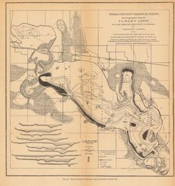
- Subject:
- Topical Subject: Lakes, Topical Subject: Hydrography, Geographic Subject: Kosciusko County (Ind.), Geographic Subject: Wawasee Lake (Ind.), and Topical Subje...
- Creator:
- Indiana University. Biological Station and Juday, Chancey, 1871-1944
- Publisher:
- Indiana. Department of Geology and Natural Resources
- Date Created:
- 1901
- Identifier:
- VAC3073-M-00996
- Genre:
- Bathymetric maps
- Geographic Location:
- Coordinates: W0854500 W0853945 N0412623 N0412211
- Related URL:
- Catalog URL: https://iucat.iu.edu/catalog/18188480
- Abstract:
- Depths shown by soundings and isolines. Map also includes locations of marshes, cat tail swamps, springs, and roads, as well as insets A-J showing cross sect...
- Call Number:
- G4092.W39 1900 .I53
- Caption:
- Imprint: [Indianapolis] : [Wm. B. Burford], [1901]
- Physical Description:
- Scale: 1:27,000. Vertical scale for cross sections 1:3,270 and Dimensions: 25 x 24 cm, on sheet 27 x 27 cm
- Alternate Identifier:
- Alternate ID: 390726IP and Title Control Number: a18188480
- Persistent URL:
- https://purl.dlib.indiana.edu/iudl/images/VAC3073/VAC3073-M-00996
- Provenance:
- 25th Annual Report (1900) / Indiana. Department of Geology and Natural Resources.
-
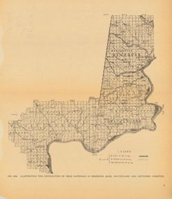
- Subject:
- Topical Subject: Gravel, Geographic Subject: Switzerland County (Ind.), Geographic Subject: Dearborn County (Ind.), Geographic Subject: Jefferson County (Ind...
- Publisher:
- Indiana. Department of Geology and Natural Resources
- Date Created:
- 1906
- Identifier:
- VAC3073-M-00276
- Genre:
- Thematic maps and Geological maps
- Geographic Location:
- Coordinates: W0854024 W0844643 N0391913 N0383439
- Related URL:
- Catalog URL: https://iucat.iu.edu/catalog/18299070
- Abstract:
- Title from caption. At head of title: Fig. 48A. Shows gravel locations. Detached from: The roads and road materials of a portion of southwestern Indiana /...
- Call Number:
- QE109 .A2 1905 map p766
- Caption:
- Imprint: [Indianapolis] : [Indiana Dept. of Geology and Natural Resources], [1906]
- Physical Description:
- Scale: Approximately 1:410,000 and Dimensions: on sheet 26 x 23 cm
- Alternate Identifier:
- Title Control Number: a18299070 and Alternate ID: 390726IP
- Persistent URL:
- https://purl.dlib.indiana.edu/iudl/images/VAC3073/VAC3073-M-00276
- Provenance:
- 30th Annual Report (1905) / Indiana. Department of Geology and Natural Resources.
-
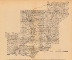
- Subject:
- Geographic Subject: Decatur County (Ind.), Topical Subject: Road materials, Topical Subject: Gravel, Topical Subject: IGS Annual Reports, Geographic Subject:...
- Publisher:
- Indiana. Department of Geology and Natural Resources
- Date Created:
- 1906
- Identifier:
- VAC3073-M-00663
- Genre:
- Geological maps and Thematic maps
- Geographic Location:
- Coordinates: W0861757 W0851758 N0392703 N0384320
- Related URL:
- Catalog URL: https://iucat.iu.edu/catalog/18299042
- Abstract:
- Title from caption. At head of title: Fig. 49B. Shows gravel locations. Detached from: The roads and road materials of a portion of southwestern Indiana /...
- Call Number:
- G4093.J6H5 1905 .I4
- Caption:
- Imprint: [Indianapolis] : [Indiana Dept. of Geology and Natural Resources], [1906]
- Physical Description:
- Scale: Approximately 1:410,000 and Dimensions: on sheet 22 x 26 cm
- Alternate Identifier:
- Title Control Number: a18299042 and Alternate ID: 390726IP
- Persistent URL:
- https://purl.dlib.indiana.edu/iudl/images/VAC3073/VAC3073-M-00663
- Provenance:
- 30th Annual Report (1905) / Indiana. Department of Geology and Natural Resources.
-
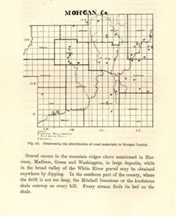
- Subject:
- Topical Subject: IGS Annual Reports, Topical Subject: Road materials, Topical Subject: Gravel, Topical Subject: Quarries and quarrying, and Geographic Subjec...
- Publisher:
- Indiana. Department of Geology and Natural Resources
- Date Created:
- 1906
- Identifier:
- VAC3073-M-01589
- Genre:
- Thematic maps
- Geographic Location:
- Coordinates: W0864109 W0861450 N0393801 N0392020
- Related URL:
- Catalog URL: https://iucat.iu.edu/catalog/18299115
- Abstract:
- Alternate title: Morgan Co. Title from caption. At head of title: Fig. 45. Detached from: The roads and road materials of a portion of southwestern Indian...
- Call Number:
- G4093.M9H5 1905 .M67
- Caption:
- Imprint: [Indianapolis] : [Indiana Dept. of Geology and Natural Resources], [1906]
- Physical Description:
- Scale: Approximately 1:366,300 and Dimensions: on sheet 17 x 14 cm
- Alternate Identifier:
- Alternate ID: 390726IP and Title Control Number: a18299115
- Persistent URL:
- https://purl.dlib.indiana.edu/iudl/images/VAC3073/VAC3073-M-01589
- Provenance:
- 30th Annual Report (1905) / Indiana. Department of Geology and Natural Resources.
-
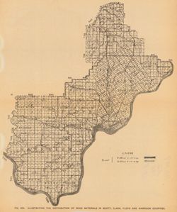
- Subject:
- Geographic Subject: Scott County (Ind.), Geographic Subject: Harrison County (Ind.), Topical Subject: Geology, Topical Subject: IGS Annual Reports, Geographi...
- Publisher:
- Indiana. Department of Geology and Natural Resources
- Date Created:
- 1906
- Identifier:
- VAC3073-M-00911
- Genre:
- Thematic maps
- Geographic Location:
- Coordinates: W0861948 W0852403 N0384955 N0375700
- Related URL:
- Catalog URL: https://iucat.iu.edu/catalog/18299034
- Abstract:
- Shows gravel locations. At head of title: Fig. 49A. Detached from: The roads and road materials of a portion of southwestern Indiana / A.E. Taylor. In Ind...
- Call Number:
- G4093.S3H5 1905 .I4
- Caption:
- Imprint: [Indianapolis] : [Indiana Dept. of Geology and Natural Resources], [1906]
- Physical Description:
- Scale: Approximately 1:371,000 and Dimensions: on sheet 27 x 23 cm
- Alternate Identifier:
- Alternate ID: 390726IP and Title Control Number: a18299034
- Persistent URL:
- https://purl.dlib.indiana.edu/iudl/images/VAC3073/VAC3073-M-00911
- Provenance:
- 30th Annual Report (1905) / Indiana. Department of Geology and Natural Resources.
-
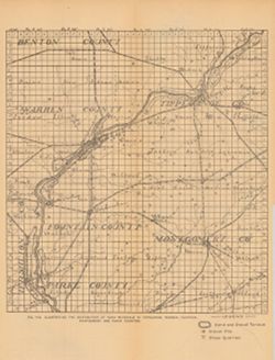
- Subject:
- Topical Subject: Road materials, Geographic Subject: Warren County (Ind.), Topical Subject: Quarries and quarrying, Topical Subject: IGS Annual Reports, Geog...
- Publisher:
- Indiana. Department of Geology and Natural Resources
- Date Created:
- 1906
- Identifier:
- VAC3073-M-00382
- Genre:
- Geological maps
- Geographic Location:
- Coordinates: W0872701 W0864139 N0403347 N0395159
- Related URL:
- Catalog URL: https://iucat.iu.edu/catalog/18299027
- Abstract:
- Shows sand and gravel terraces, gravel pits, and stone quarries. At head of title: Fig. 41B. Detached from: The roads and road materials of a portion of s...
- Call Number:
- G4093.T4H5 1905 .I4
- Caption:
- Imprint: [Indianapolis] : [Indiana Dept. of Geology and Natural Resources], [1906]
- Physical Description:
- Scale: Approximately 1:284,000 and Dimensions: 36 x 27 cm
- Alternate Identifier:
- Title Control Number: a18299027 and Alternate ID: 390726IP
- Persistent URL:
- https://purl.dlib.indiana.edu/iudl/images/VAC3073/VAC3073-M-00382
- Provenance:
- 30th Annual Report (1905) / Indiana. Department of Geology and Natural Resources.
-
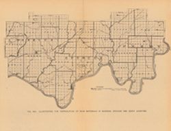
- Subject:
- Topical Subject: Road materials, Geographic Subject: Spencer County (Ind.), Topical Subject: IGS Annual Reports, Geographic Subject: Perry County (Ind.), Geo...
- Publisher:
- Indiana. Department of Geology and Natural Resources
- Date Created:
- 1906
- Identifier:
- VAC3073-M-00639
- Genre:
- Thematic maps
- Geographic Location:
- Coordinates: W0872820 W0862738 N0381552 N0374626
- Related URL:
- Catalog URL: https://iucat.iu.edu/catalog/18298932
- Abstract:
- Caption title. At head of title: Fig. 58A. Shows areas with workable amounts of limestone not yet opened and areas containing limestone outcrops. Detached...
- Call Number:
- G4093.W4H5 1905 .I4
- Caption:
- Imprint: [Indianapolis] : [Indiana Dept. of Geology and Natural Resources], [1906]
- Physical Description:
- Dimensions: on sheet 20 x 26 cm and Scale: Approximately 1:380,160
- Alternate Identifier:
- Title Control Number: a18298932 and Alternate ID: 390726IP
- Persistent URL:
- https://purl.dlib.indiana.edu/iudl/images/VAC3073/VAC3073-M-00639
- Provenance:
- 30th Annual Report (1905) / Indiana. Department of Geology and Natural Resources.
-
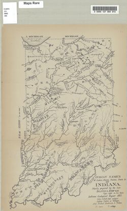
- Subject:
- Topical Subject: IGS Annual Reports, Geographic Subject: Indiana, Topical Subject: Names, Indian, and Topical Subject: Names, Geographical
- Creator:
- Hough, Daniel
- Publisher:
- Indiana. Department of Geology and Natural Resources
- Date Created:
- 1883
- Identifier:
- VAC3073-M-01015
- Genre:
- Thematic maps
- Geographic Location:
- Coordinates: W0880500 W0844700 N0414500 N0374600
- Related URL:
- Catalog URL: https://iucat.iu.edu/catalog/8739692
- Abstract:
- Includes references to the Wyandotte, Kickapoo, Deleware, Piankeshaw, Shawnee, Miami, Mosquitan, Wea, and Potawatomi tribes. "Copyright in his heirs.&qu...
- Call Number:
- G4091.A8 1883 .H68
- Caption:
- Imprint: [Indianapolis] : [Department of Geology and Natural History], [1883]
- Physical Description:
- Dimensions: on sheet 34 x 23 cm and Scale: Approximately 1:1,501,358
- Alternate Identifier:
- Title Control Number: a17035883 and Alternate ID: 390725IP
- Persistent URL:
- https://purl.dlib.indiana.edu/iudl/images/VAC3073/VAC3073-M-01015
- Provenance:
- 12th Annual Report (1882) / Indiana. Department of Geology and Natural History.
-
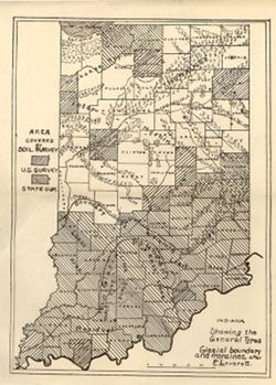
- Subject:
- Topical Subject: Soil surveys, Geographic Subject: Indiana, Topical Subject: IGS Annual Reports, Topical Subject: Moraines, and Topical Subject: Glacial epoch
- Publisher:
- Indiana. Department of Geology and Natural Resources
- Date Created:
- 1912
- Identifier:
- VAC3073-M-01144
- Genre:
- Thematic maps and Index maps
- Geographic Location:
- Coordinates: W0880500 W0844700 N0414500 N0374600
- Related URL:
- Catalog URL: https://iucat.iu.edu/catalog/18307837
- Abstract:
- Shows counties covered by a U.S. soil survey or a state soil survey. Detached from: Glaciation and soils / Edward Barrett. In Thirty-sixth annual report o...
- Call Number:
- G4091.C38 1911 .I5
- Caption:
- Imprint: [Indianapolis] : [Department of Geology and Natural Resources, Indiana], [1912]
- Physical Description:
- Scale: Approximately 1:1,750,000 and Dimensions: 24 x 18 cm
- Alternate Identifier:
- Alternate ID: 390726IP and Title Control Number: a18307837
- Persistent URL:
- https://purl.dlib.indiana.edu/iudl/images/VAC3073/VAC3073-M-01144
- Provenance:
- 36th Annual Report (1911) / Indiana. Department of Geology and Natural Resources.
-
- Subject:
- Geographic Subject: Indiana and Topical Subject: IGS Annual Reports
- Publisher:
- Indiana. Department of Geology and Natural Resources
- Date Created:
- 1907
- Identifier:
- VAC3073-M-00929
- Genre:
- Charts
- Related URL:
- Catalog URL: https://iucat.iu.edu/catalog/4022271
- Abstract:
- From page 290 of 31st Annual Report.
- Call Number:
- QE109 .A2 1906
- Caption:
- Imprint: Indianapolis : 1907
- Physical Description:
- Dimensions: 19 x 63 cm
- Alternate Identifier:
- Title Control Number: 390726IP
- Persistent URL:
- https://purl.dlib.indiana.edu/iudl/images/VAC3073/VAC3073-M-00929
- Provenance:
- 31st Annual Report (1906) / Indiana. Department of Geology and Natural Resources.
-
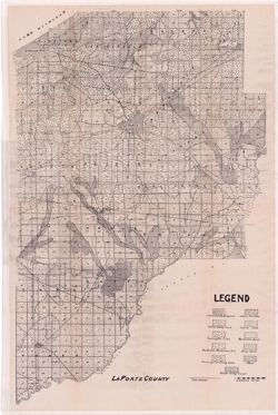
- Subject:
- Topical Subject: IGS Annual Reports, Topical Subject: Soils, Geographic Subject: LaPorte County (Ind.), and Topical Subject: Soil surveys
- Publisher:
- Indiana. Department of Geology and Natural Resources
- Date Created:
- 1912
- Identifier:
- VAC3073-M-01082
- Genre:
- Thematic maps
- Geographic Location:
- Coordinates: W0865600 W0862910 N0414539 N0411412
- Related URL:
- Catalog URL: https://iucat.iu.edu/catalog/16131280
- Abstract:
- Variant title: La Porte County. Shows soil types, dirt roads, improved roads, and railroads. Detached from: Soil survey of Laporte County / E.J. Quinn. In...
- Call Number:
- G4093.L15J3 1911 .L37
- Caption:
- Imprint: [Indianapolis] : [Wm. B. Burford], [1912] and Imprint: [Indianapolis] : [Department of Geology and Natural Resources, Indiana], [1912]
- Physical Description:
- Dimensions: on sheet 70 x 46 cm
- Alternate Identifier:
- Title Control Number: a16131280 and Alternate ID: 390726IP
- Persistent URL:
- https://purl.dlib.indiana.edu/iudl/images/VAC3073/VAC3073-M-01082
- Provenance:
- 36th Annual Report (1911) / Indiana. Geological Survey.
-
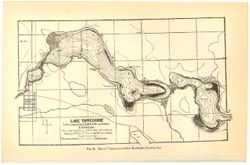
- Subject:
- Topical Subject: Lakes, Topical Subject: IGS Annual Reports, Geographic Subject: Tippecanoe, Lake (Ind.), and Geographic Subject: Kosciusko County (Ind.)
- Creator:
- Mase, Thomas L.
- Publisher:
- Indiana. Department of Geology and Natural Resources
- Date Created:
- 1901
- Identifier:
- VAC3073-M-01170
- Genre:
- Bathymetric maps
- Related URL:
- Catalog URL: https://iucat.iu.edu/catalog/4022271
- Call Number:
- QE109 .A2 1900 map p186
- Caption:
- Imprint: Indianapolis : Burford, 1901.
- Physical Description:
- Dimensions: 15 x 23 cm
- Persistent URL:
- https://purl.dlib.indiana.edu/iudl/images/VAC3073/VAC3073-M-01170
- Provenance:
- 25th Annual Report (1900) / Indiana. Department of Geology and Natural Resources.
-
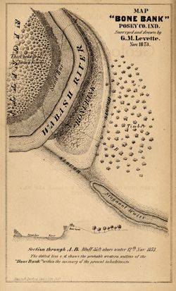
- Subject:
- Geographic Subject: Bone Bank Site (Ind.), Topical Subject: IGS Annual Reports, Geographic Subject: Posey County (Ind.), Topical Subject: Mississippian cultu...
- Creator:
- Levette, G. M. (Gilbert M.)
- Publisher:
- Indiana. Geological Survey
- Date Created:
- 1874
- Identifier:
- VAC3073-M-01540
- Genre:
- Pictorial maps and Geological cross-sections
- Geographic Location:
- Coordinates: W0880126 W0880126 N0374955 N0374955
- Related URL:
- Catalog URL: https://iucat.iu.edu/catalog/18308000
- Abstract:
- 1 map and 1 section on 1 sheet. Surveyed and drawn by G.M. Levette Nov. 1873. Shows the "probable western outline of the 'Bone Bank' within the ...
- Call Number:
- G4093.P6E15 1873 .L48
- Caption:
- Imprint: Inds. : Braden & Burford Steam Lith. [1874] and Imprint: [Indianapolis] : [Geological Survey of Indiana], [1874]
- Physical Description:
- Scale: Not drawn to scale. and Dimensions: on sheet 20 x 12 cm
- Alternate Identifier:
- Alternate ID: 390723IP and Title Control Number: a18308000
- Persistent URL:
- https://purl.dlib.indiana.edu/iudl/images/VAC3073/VAC3073-M-01540
- Provenance:
- 5th Annual Report (1873) / Indiana. Geological Survey.
-
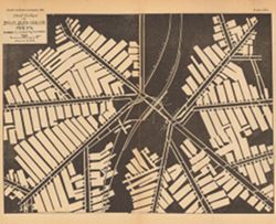
- Subject:
- Geographic Subject: Clay County (Ind.), Topical Subject: IGS Annual Reports, Topical Subject: Coal mines and mining, and Topical Subject: Brazil Block Coal C...
- Creator:
- Mooney, P. J. and Ashley, Geo. H. (George Hall), 1866-1951
- Publisher:
- Indiana. Department of Geology and Natural Resources
- Date Created:
- 1898
- Identifier:
- VAC3073-M-00271
- Genre:
- Mine maps
- Geographic Location:
- Coordinates: W0870943 W0870728 N0393621 N0393534
- Related URL:
- Catalog URL: https://iucat.iu.edu/catalog/18244670
- Abstract:
- Plate XIX. Planned and laid out by P.J. Mooney , drawn by G.H.A. Detached from: The coal deposits of Indiana / George Hall Ashley. In Indiana Dept. of Geo...
- Call Number:
- G4093.C5H9 1898 .A8
- Caption:
- Imprint: [Indianapolis] : [Dept. of Geology and Natural Resources of Indiana], [1899]
- Physical Description:
- Dimensions: 22 x 26 cm and Scale: Approximately 1:2,400
- Alternate Identifier:
- Title Control Number: a18244670 and Alternate ID: 390726IP
- Persistent URL:
- https://purl.dlib.indiana.edu/iudl/images/VAC3073/VAC3073-M-00271
- Provenance:
- 23rd Annual Report (1898) / Indiana. Department of Geology and Natural Resources.
-
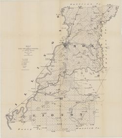
- Subject:
- Geographic Subject: Knox County (Ind.), Topical Subject: Geology, Topical Subject: Mines and mineral resources, Topical Subject: IGS Annual Reports, and Geog...
- Creator:
- Indiana. Geological Survey
- Publisher:
- Indiana. Geological Survey
- Date Created:
- 1874
- Identifier:
- VAC3073-M-01451
- Genre:
- Geological maps
- Related URL:
- Catalog URL: https://iucat.iu.edu/catalog/4022269
- Call Number:
- QE109 .A2 1874
- Caption:
- Imprint: Indianapolis : 1874.
- Persistent URL:
- https://purl.dlib.indiana.edu/iudl/images/VAC3073/VAC3073-M-01451
- Provenance:
- 5th Annual Report (1873) / Indiana. Geological Survey.
-
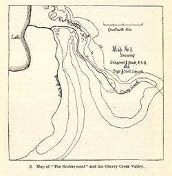
- Subject:
- Topical Subject: IGS Annual Reports, Geographic Subject: Cherry Creek (Ind.), and Topical Subject: Rivers
- Publisher:
- Indiana. Department of Geology and Natural Resources
- Date Created:
- 1904
- Identifier:
- VAC3073-M-01580
- Genre:
- Maps
- Related URL:
- Catalog URL: new.iucat.iu.edu/catalog/4022271
- Call Number:
- QE109 .A2 1903
- Caption:
- Imprint: Indianapolis : 1904.
- Persistent URL:
- https://purl.dlib.indiana.edu/iudl/images/VAC3073/VAC3073-M-01580
- Provenance:
- 28th Annual Report (1903) / Indiana. Department of Geology and Natural Resources.
-
![Map No. 4 showing locations of upper & lower dams [Winona Lake Region, Indiana]](https://iiif.uits.iu.edu/iiif/2/3j3345867%2Ffiles%2Fcfcf70eb-0483-44d3-b9ee-e305909b40f2/full/250,/0/default.jpg)
- Subject:
- Geographic Subject: Kosciusko County (Ind.), Geographic Subject: Winona Lake Region (Ind. : Lake), Topical Subject: IGS Annual Reports, and Topical Subject: ...
- Publisher:
- Indiana. Department of Geology and Natural Resources
- Date Created:
- 1904
- Identifier:
- VAC3073-M-01583
- Genre:
- Topographic maps and Geological cross-sections
- Geographic Location:
- Coordinates: W0855154 W0855032 N0411406 N0411308
- Related URL:
- Catalog URL: https://iucat.iu.edu/catalog/18418357
- Abstract:
- Relief shown by contours and profile. Shows location of dams on Winona Lake outlet near Warsaw in Kosciusko County, Indiana, and cross-sections of upper and ...
- Call Number:
- G4093.K6N2 1903 .M3
- Caption:
- Imprint: [Indianapolis] : [Wm. B. Burford], [1904] and Imprint: [Indianapolis] : [Indiana Department of Geology and Natural Resources], [1904]
- Physical Description:
- Dimensions: on sheet 10 x 10 cm and Scale: Approximately 1:20,100. Vertical scale varies
- Alternate Identifier:
- Title Control Number: a18418357 and Alternate ID: 390726IP
- Persistent URL:
- https://purl.dlib.indiana.edu/iudl/images/VAC3073/VAC3073-M-01583
- Provenance:
- 28th Annual Report (1903) / Indiana. Department of Geology and Natural Resources.
-
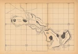
- Subject:
- Geographic Subject: Irish Lake (Ind.), Geographic Subject: Kosciusko County (Ind.), Geographic Subject: Big Barbee Lake (Ind.), Topical Subject: IGS Annual R...
- Publisher:
- Indiana. Department of Geology and Natural Resources
- Date Created:
- 1901
- Identifier:
- VAC3073-M-00295
- Genre:
- Maps
- Geographic Location:
- Coordinates: W0854443 W0854115 N0411820 N0411636
- Related URL:
- Catalog URL: https://iucat.iu.edu/catalog/18189963
- Abstract:
- Shows Barbee chain of lakes and local clubs and parks. Names of lakes as shown on map: Irish, Mabie (Sawmill), Plew (Sechrist), Kuhn (Little Barbee), Hammon ...
- Call Number:
- G4092.B3 1900 .M3
- Caption:
- Imprint: [Indianapolis] : [Dept. of Geology and Natural Resources], [1901]
- Physical Description:
- Dimensions: 22 x 32 cm
- Alternate Identifier:
- Title Control Number: a18189963 and Alternate ID: 390726IP
- Persistent URL:
- https://purl.dlib.indiana.edu/iudl/images/VAC3073/VAC3073-M-00295
- Provenance:
- 25th Annual Report (1900) / Indiana. Department of Geology and Natural Resources.
-
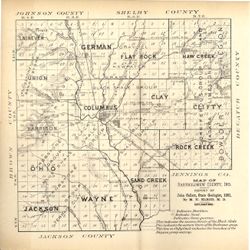
- Subject:
- Topical Subject: Geology, Topical Subject: IGS Annual Reports, Topical Subject: Quarries and quarrying, and Geographic Subject: Bartholomew County (Ind.)
- Creator:
- Elrod, M. N. (Moses Newton), 1838-1907
- Publisher:
- Indiana. Department of Geology and Natural History
- Date Created:
- 1882
- Identifier:
- VAC3073-M-01151
- Genre:
- Geological maps
- Geographic Location:
- Coordinates: W0860508 W0854104 N0392100 N0390209
- Related URL:
- Catalog URL: https://iucat.iu.edu/catalog/18174102
- Abstract:
- Relief shown by hachures. Shows boulders, sand, and stone quarries. Detached from: Geology of Bartholomew County / Moses N. Elrod. In Indiana Department o...
- Call Number:
- G4093.B3C5 1881 .E4
- Caption:
- Imprint: [Indianapolis] : [Indiana Department of Geology and Natural History], [1882]
- Physical Description:
- Dimensions: 23 x 23 cm and Scale: Approximately 1:190,000
- Alternate Identifier:
- Title Control Number: a18174102 and Alternate ID: 390725IP
- Persistent URL:
- https://purl.dlib.indiana.edu/iudl/images/VAC3073/VAC3073-M-01151
- Provenance:
- 11th Annual Report (1881) / Indiana. Department of Geology and Natural History.
-
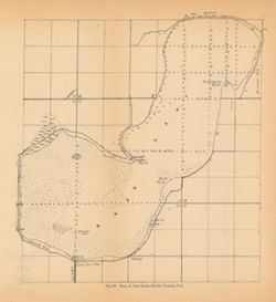
- Subject:
- Geographic Subject: Bass Lake (Starke County, Ind. : Lake), Topical Subject: IGS Annual Reports, Geographic Subject: Starke County (Ind.), and Topical Subjec...
- Publisher:
- Indiana. Department of Geology and Natural Resources
- Date Created:
- 1901
- Identifier:
- VAC3073-M-00348
- Genre:
- Maps
- Geographic Location:
- Coordinates: W0863646 W0863409 N0411431 N0411221
- Related URL:
- Catalog URL: https://iucat.iu.edu/catalog/18189994
- Abstract:
- Depth shown by soundings. Title from caption. Detached from: The lakes of northern Indiana and their associated marl deposits / W. S. Blatchley and Geo. ...
- Call Number:
- G4092.B35 1900 .M37
- Caption:
- Imprint: [Indianapolis] : [Indiana, Department of Geology and Natural Resources], [1901] and Imprint: [Indianapolis] : [Wm. B. Burford], [1901]
- Physical Description:
- Dimensions: 22 x 21 cm and Scale: Approximately 1:21,500
- Alternate Identifier:
- Alternate ID: 390726IP and Title Control Number: a18189994
- Persistent URL:
- https://purl.dlib.indiana.edu/iudl/images/VAC3073/VAC3073-M-00348
- Provenance:
- 25th Annual Report (1900) / Indiana. Department of Geology and Natural Resources.
-
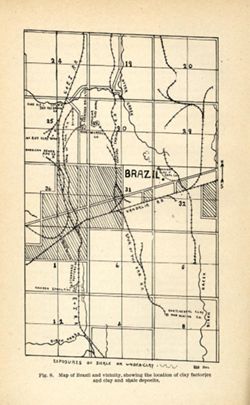
- Subject:
- Geographic Subject: Brazil (Ind.), Topical Subject: IGS Annual Reports, Topical Subject: Clay industries, and Topical Subject: Clay
- Creator:
- Blatchley, Raymond S. (Raymond Sillliman)
- Publisher:
- Indiana. Department of Geology and Natural Resources
- Date Created:
- 1905
- Identifier:
- VAC3073-M-01586
- Genre:
- Geological maps
- Geographic Location:
- Coordinates: W0870852 W0870554 N0393212 N0393014
- Related URL:
- Catalog URL: https://iucat.iu.edu/catalog/18279473
- Abstract:
- Title from caption. "Fig. 8." "RSB DEL." Shows locations of clay deposits as well as mining, clay works, brick, and sewer pipe companies....
- Call Number:
- G4093.P2H5 1904 .B75
- Caption:
- Imprint: [Indianapolis] : [Wm. B. Burford], [1905] and Imprint: [Indianapolis] : [Indiana Department of Geology and Natural Resources], [1905]
- Physical Description:
- Scale: Approximately 1:46,650 and Dimensions: on sheet 22 x 14 cm
- Alternate Identifier:
- Title Control Number: a18279473 and Alternate ID: 390726IP
- Persistent URL:
- https://purl.dlib.indiana.edu/iudl/images/VAC3073/VAC3073-M-01586
- Provenance:
- 29th Annual Report (1904) / Indiana. Department of Geology and Natural Resources.
-
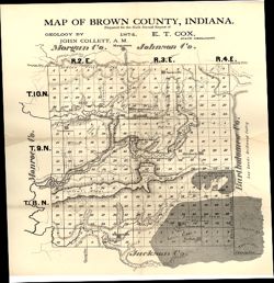
- Subject:
- Topical Subject: IGS Annual Reports, Geographic Subject: Brown County (Ind.), Topical Subject: Geology, and Topical Subject: Mines and mineral resources
- Creator:
- Collett, John, 1828-1899
- Publisher:
- Indiana. Geological Survey
- Date Created:
- 1875
- Identifier:
- VAC3073-M-01148
- Genre:
- Geological maps
- Geographic Location:
- Coordinates: W0862253 W0860449 N0392042 N0390248
- Related URL:
- Catalog URL: https://iucat.iu.edu/catalog/18318678
- Abstract:
- Prepared for the sixth annual report of E.T. Cox, State Geologist , geology by John Collett, 1874. Relief shown by hachures. Shows cities and towns, railroad...
- Call Number:
- G4093.B7C5 1874 .C6
- Caption:
- Imprint: [Indianapolis] : [Sentinel Company, printers], [1875] and Imprint: [Indianapolis] : [Geological Survey of Indiana], [1875]
- Physical Description:
- Scale: Approximately 1:120,000 and Dimensions: on sheet 39 x 35 cm
- Alternate Identifier:
- Alternate ID: 390723IP and Title Control Number: a18318678
- Persistent URL:
- https://purl.dlib.indiana.edu/iudl/images/VAC3073/VAC3073-M-01148
- Provenance:
- 6th Annual Report (1874) / Indiana. Geological Survey.
-
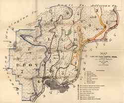
- Subject:
- Topical Subject: Geology, Geographic Subject: Clark County (Ind.), Topical Subject: Mines and mineral resources, Geographic Subject: Floyd County (Ind.), and...
- Creator:
- Cox, E. T. (Edward Travers), 1821-1907 and Borden, W. W. (William Wesley), 1823-1906
- Publisher:
- Indiana. Geological Survey
- Date Created:
- 1874
- Identifier:
- VAC3073-M-01155
- Genre:
- Geological maps
- Geographic Location:
- Coordinates: W0860258 W0852426 N0383636 N0380900
- Related URL:
- Catalog URL: https://iucat.iu.edu/catalog/18318611
- Abstract:
- Prepared for the 5th annual report of Prof. E.T. Cox, State Geologist, 1873 , geology by W.W. Borden. Relief shown by hachures. Shows cities and towns, railr...
- Call Number:
- G4093.C4C5 1873 .B6
- Caption:
- Imprint: [Indianapolis] : [Geological Survey of Indiana], [1874] and Imprint: [Indianapolis] : [Sentinel Co., printers], [1874]
- Physical Description:
- Dimensions: on sheet 41 x 49 cm and Scale: Approximately 1:130,000
- Alternate Identifier:
- Alternate ID: 390723IP and Title Control Number: a18318611
- Persistent URL:
- https://purl.dlib.indiana.edu/iudl/images/VAC3073/VAC3073-M-01155
- Provenance:
- 5th Annual Report (1873) / Indiana. Geological Survey.
-
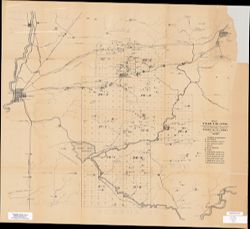
- Subject:
- Geographic Subject: Clay County (Ind.), Topical Subject: IGS Annual Reports, and Topical Subject: Coal
- Creator:
- Levette, G. M. (Gilbert M.)
- Publisher:
- Indiana. Geological Survey
- Date Created:
- 1869
- Identifier:
- VAC3073-M-00669
- Genre:
- Thematic maps
- Geographic Location:
- Coordinates: W0871400 W0865700 N0393700 N0391000
- Related URL:
- Catalog URL: https://iucat.iu.edu/catalog/2800455
- Abstract:
- Shows cities and towns, railroads, coal, iron ore, and blast furnaces. "For the first annual report of Prof. E. T. Cox, State Geologist." Detach...
- Call Number:
- G4093 .C5H1 1869 .L3
- Caption:
- Imprint: [Indianapolis] : [Alexander M. Conner], [1869]
- Physical Description:
- Dimensions: 77 x 69 cm and Scale: Approximately 1:85,000
- Alternate Identifier:
- Alternate ID: CAH3779BB and Title Control Number: a18224823
- Persistent URL:
- https://purl.dlib.indiana.edu/iudl/images/VAC3073/VAC3073-M-00669
- Provenance:
- 1st Annual Report (1869) / Indiana. Geological Survey
-
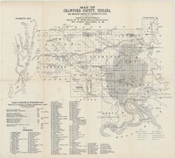
- Subject:
- Topical Subject: IGS Annual Reports, Topical Subject: Coal mines and mining, Geographic Subject: Crawford County (Ind.), Geographic Subject: Wyandotte Cave (...
- Creator:
- Collett, John, 1828-1899
- Publisher:
- Indiana. Geological Survey
- Date Created:
- 1879
- Identifier:
- VAC3073-M-01546
- Genre:
- Thematic maps
- Geographic Location:
- Coordinates: W0863746 W0861445 N0382324 N0380600
- Related URL:
- Catalog URL: https://iucat.iu.edu/catalog/18349479
- Abstract:
- Prepared for 10th annual report of Prof. E.T. Cox, State Geologist by John Collett, 1878. Relief shown by hachures. Shows cities and towns, railroads, cavern...
- Call Number:
- G4093.C7C5 1878 .C6
- Caption:
- Imprint: [Indianapolis] : [Geological Survey of Indiana], [1879] and Imprint: [Indianapolis] : [Indianapolis Journal Company, State printers], [1879]
- Physical Description:
- Scale: Approximately 1:125,000 and Dimensions: on sheet 39 x 44 cm
- Alternate Identifier:
- Title Control Number: a18349479 and Alternate ID: 390723IP
- Persistent URL:
- https://purl.dlib.indiana.edu/iudl/images/VAC3073/VAC3073-M-01546
- Provenance:
- 8th, 9th, and 10th Annual Reports (1876, 1877, 1878) / Indiana. Geological Survey.
-
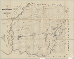
- Subject:
- Topical Subject: IGS Annual Reports, Topical Subject: Geology, Economic, Geographic Subject: Daviess County (Ind.), Geographic Subject: Martin County (Ind.),...
- Creator:
- Collett, John, 1828-1899, Levette, G. M. (Gilbert M.), and Cox, E. T. (Edward Travers), 1821-1907
- Publisher:
- Indiana. Geological Survey
- Date Created:
- 1871
- Identifier:
- VAC3073-M-01263
- Genre:
- Geological maps
- Geographic Location:
- Coordinates: W0871645 W0863823 N0385617 N0382924
- Related URL:
- Catalog URL: https://iucat.iu.edu/catalog/18282530
- Abstract:
- Drawn by G.M. Levette for the second annual report of Prof. E.T. Cox, state geologist , [geology by John Collett]. Shows worked coal, coal outcrops, iron ore...
- Call Number:
- G4093.D2H1 1870 .L4
- Caption:
- Imprint: Indianapolis, Ind. : Geological Survey of Indiana, [1871]
- Physical Description:
- Scale: Approximately 1:85,000 and Dimensions: on sheet 63 x 79 cm
- Alternate Identifier:
- Alternate ID: 390721IP and Title Control Number: a18282530
- Persistent URL:
- https://purl.dlib.indiana.edu/iudl/images/VAC3073/VAC3073-M-01263
- Provenance:
- 2nd Annual Report (1870) / Indiana. Geological Survey.
-
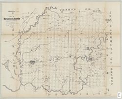
- Subject:
- Topical Subject: Geology, Economic, Geographic Subject: Martin County (Ind.), Geographic Subject: Daviess County (Ind.), Topical Subject: IGS Annual Reports,...
- Creator:
- Collett, John, 1828-1899, Cox, E. T. (Edward Travers), 1821-1907, and Levette, G. M. (Gilbert M.)
- Publisher:
- Indiana. Geological Survey
- Date Created:
- 1871
- Identifier:
- VAC3073-M-01531
- Genre:
- Geological maps
- Geographic Location:
- Coordinates: W0871645 W0863823 N0385617 N0382924
- Related URL:
- Catalog URL: https://iucat.iu.edu/catalog/18282530
- Abstract:
- Drawn by G.M. Levette for the second annual report of Prof. E.T. Cox, state geologist , [geology by John Collett]. Shows worked coal, coal outcrops, iron ore...
- Call Number:
- G4093.D2H1 1870 .L4
- Caption:
- Imprint: Indianapolis, Ind. : Geological Survey of Indiana, [1871]
- Physical Description:
- Scale: Approximately 1:85,000 and Dimensions: on sheet 63 x 79 cm
- Alternate Identifier:
- Title Control Number: a18282530 and Alternate ID: 390721IP
- Persistent URL:
- https://purl.dlib.indiana.edu/iudl/images/VAC3073/VAC3073-M-01531
- Provenance:
- 2nd Annual Report (1870) / Indiana. Geological Survey.
-
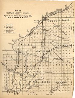
- Subject:
- Geographic Subject: Fountain County (Ind.), Topical Subject: Mines and mineral resources, Topical Subject: Geology, and Topical Subject: IGS Annual Reports
- Publisher:
- Indiana. Department of Geology and Natural Resources
- Date Created:
- 1882
- Identifier:
- VAC3073-M-01135
- Genre:
- Geological maps
- Related URL:
- Catalog URL: https://iucat.iu.edu/catalog/4022270
- Abstract:
- From page 88 of the 11th Annual Report.
- Call Number:
- QE109 .A2 1881 map p88
- Caption:
- Imprint: Indianapolis : 1882.
- Physical Description:
- Dimensions: 29 x 22 cm
- Alternate Identifier:
- Title Control Number: 390725IP
- Persistent URL:
- https://purl.dlib.indiana.edu/iudl/images/VAC3073/VAC3073-M-01135
- Provenance:
- 11th Annual Report (1881) / Indiana. Department of Geology and Natural History.
-
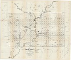
- Subject:
- Topical Subject: Mines and mineral resources, Geographic Subject: Greene County (Ind.), and Topical Subject: IGS Annual Reports
- Creator:
- Levette, G. M. (Gilbert M.)
- Publisher:
- Indiana. Geological Survey
- Date Created:
- 1869
- Identifier:
- VAC3073-M-01449
- Genre:
- Thematic maps
- Geographic Location:
- Coordinates: W0871431 W0864053 N0391018 N0385418
- Related URL:
- Catalog URL: https://iucat.iu.edu/catalog/18189063
- Abstract:
- Shows towns, railroads, coal and iron ore, mills, furnaces, and stone quarries. "For the first annual report of Prof. E.T. Cox, State Geologist." ...
- Call Number:
- G4093.G7H1 1869 .L3
- Caption:
- Imprint: [Indianapolis] : [Alexander M. Conner], [1869]
- Physical Description:
- Dimensions: 61 x 71 cm and Scale: Approximately 1:85,000
- Alternate Identifier:
- Title Control Number: a18189063
- Persistent URL:
- https://purl.dlib.indiana.edu/iudl/images/VAC3073/VAC3073-M-01449
- Provenance:
- 1st Annual Report (1869) / Indiana. Geological Survey
-
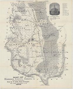
- Subject:
- Topical Subject: Mines and mineral resources, Topical Subject: IGS Annual Reports, Geographic Subject: Harrison County (Ind.), Topical Subject: Corydon Capit...
- Creator:
- Collett, John, 1828-1899
- Publisher:
- Indiana. Geological Survey
- Date Created:
- 1879
- Identifier:
- VAC3073-M-01554
- Genre:
- Geological maps
- Geographic Location:
- Coordinates: W0861951 W0855359 N0382520 N0375731
- Related URL:
- Catalog URL: https://iucat.iu.edu/catalog/18363798
- Abstract:
- Prepared for the 10th annual report of Prof. E.T. Cox, State Geologist by John Collett, 1878. Relief shown by hachures. Shows cities and towns, railroads, sp...
- Call Number:
- G4093.H4C5 1878 .C6
- Caption:
- Imprint: [Indianapolis] : [Geological Survey of Indiana], [1879] and Imprint: [Indianapolis] : [Indianapolis Journal Company, State printers], [1879]
- Physical Description:
- Dimensions: on sheet 44 x 36 cm and Scale: Approximately 1:130,000
- Alternate Identifier:
- Alternate ID: 390723IP and Title Control Number: a18363798
- Persistent URL:
- https://purl.dlib.indiana.edu/iudl/images/VAC3073/VAC3073-M-01554
- Provenance:
- 8th, 9th, and 10th Annual Reports (1876, 1877, 1878) / Indiana. Geological Survey.
