
Search Constraints
You searched for:
Type
Image
Remove constraint Type: Image
Collections
Indiana Historic Maps
Remove constraint Collections: Indiana Historic Maps
« Previous |
1 - 100 of 1,237
|
Next »
Search Results
-
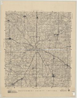
- Subject:
- Topical Subject: Landowners, Topical Subject: Real property, and Geographic Subject: Montgomery County (Ind.)
- Creator:
- Donica, Roy E.
- Publisher:
- Roy E. Donica and Karl M. Laurimore
- Date Created:
- 1941
- Identifier:
- VAC3073-M-00217
- Genre:
- Cadastral maps
- Geographic Location:
- Coordinates: W0870600 W0864200 N0401300 N0395200
- Related URL:
- Catalog URL: https://iucat.iu.edu/catalog/5383100
- Abstract:
- Cadastral map showing landowners. "1940-1941."
- Call Number:
- G4093.M8 G46 1941 .D66
- Caption:
- Imprint: [Crawfordsville, Ind.] : Roy E. Donica and Karl M. Laurimore, [1941].
- Physical Description:
- Dimensions: 125 x 125 cm and Scale: 1:31,680
- Alternate Identifier:
- Title Control Number: a5383100
- Persistent URL:
- https://purl.dlib.indiana.edu/iudl/images/VAC3073/VAC3073-M-00217
-
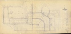
- Subject:
- Geographic Subject: Bloomington (Ind.) and Topical Subject: Urban renewal
- Creator:
- Bloomington (Ind.). Department of Redevelopment
- Publisher:
- Bloomington (Ind.). Department of Redevelopment
- Date Created:
- 1964
- Identifier:
- VAC3073-M-00223
- Genre:
- Thematic maps
- Geographic Location:
- Coordinates: W0861450 W0861206 N0391319 N0391131
- Related URL:
- Catalog URL: https://iucat.iu.edu/catalog/5299416
- Abstract:
- Blue line print. y D.A.H., approved by C.M.C." "Revised Aug. 1964."
- Call Number:
- G4094.B5 G455 1964 .B5
- Caption:
- Imprint: [Bloomington, Ind.?] : [The Dept.?], [1964?]
- Physical Description:
- Scale: 1:600 and Dimensions: 191 x 88 cm
- Alternate Identifier:
- Title Control Number: a5299416
- Persistent URL:
- https://purl.dlib.indiana.edu/iudl/images/VAC3073/VAC3073-M-00223
-
- Subject:
- Topical Subject: Oil fields, Geographic Subject: Indiana, and Topical Subject: Gas fields
- Creator:
- Cazee, J. T. (James T.)
- Publisher:
- Indiana. Geological Survey
- Date Created:
- 1998
- Identifier:
- VAC3073-M-00237
- Genre:
- Geological maps
- Geographic Location:
- W0880000 W0860000 N0395000 N0380000 and Coordinates: W0880700 W0844500 N0414500 N0375200
- Related URL:
- Catalog URL: https://iucat.iu.edu/catalog/4995550
- Abstract:
- "Compilation complete to December 1998." "Base map digitized from 1978 U.S. Geological Survey map of Indiana. Scale 1:500,000."
- Call Number:
- G4091.H8 1998 .C3
- Caption:
- Imprint: Bloomington : Indiana Geological Survey, 1998.
- Physical Description:
- Scale: 1:550,000, 1:1:275,000, and Dimensions: 83 x 150 cm
- Alternate Identifier:
- Title Control Number: a4995550
- Persistent URL:
- https://purl.dlib.indiana.edu/iudl/images/VAC3073/VAC3073-M-00237
-
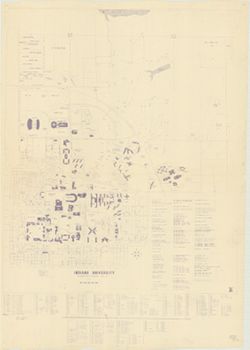
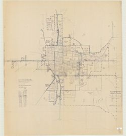
- Subject:
- Geographic Subject: Indiana University, Bloomington, Geographic Subject: Bloomington (Ind.), and Topical Subject: Indiana University, Bloomington
- Publisher:
- Indiana University?
- Date Created:
- 1969
- Identifier:
- VAC3073-M-00308
- Genre:
- Maps
- Geographic Location:
- Coordinates: W0863143 W0862959 N0391153 N0390939
- Related URL:
- Catalog URL: http://.iucat.iu.edu/catalog/5295258
- Abstract:
- Blue line print. Includes index to buildings. "12/1/69 B.W."
- Call Number:
- G4094.B5:2I6 1969 .I6
- Caption:
- Imprint: [Bloomington, Ind.? : Indiana University?, 1969?]
- Physical Description:
- Scale: 1:3,600 and Dimensions: 122 x 101 cm
- Alternate Identifier:
- Title Control Number: a5295258
- Persistent URL:
- https://purl.dlib.indiana.edu/iudl/images/VAC3073/VAC3073-M-00308
-
- Subject:
- Topical Subject: Water utilities and Geographic Subject: Danville (Ind.)
- Creator:
- Shartle, Stanley Musgrave
- Publisher:
- Stanley M. Shartle?]
- Date Created:
- 1947
- Identifier:
- VAC3073-M-00611
- Genre:
- Thematic maps
- Geographic Location:
- Coordinates: W0863309 W0862726 N0394705 N0394353
- Related URL:
- Catalog URL: https://iucat.iu.edu/catalog/5359312
- Abstract:
- Blue line print. Includes index of "References and descriptions of the location of gate valves."
- Call Number:
- G4094 .D3 N44 1947 .S53
- Caption:
- Imprint: [Danville, Ind.?] : [Stanley M. Shartle?], [1947]
- Physical Description:
- Scale: 1:1,200 and Dimensions: 87 x 198 cm
- Alternate Identifier:
- Title Control Number: a5359312
- Persistent URL:
- https://purl.dlib.indiana.edu/iudl/images/VAC3073/VAC3073-M-00611
-
- Subject:
- Topical Subject: Land use and Geographic Subject: Terre Haute (Ind.)
- Creator:
- Indiana. Governor's Commission on Unemployment Relief
- Publisher:
- Indiana. Governor's Commission on Unemployment Relief
- Date Created:
- 1935
- Identifier:
- VAC3073-M-00366
- Genre:
- Thematic maps
- Geographic Location:
- Coordinates: W0872810 W0871636 N0393142 N0392405
- Related URL:
- Catalog URL: https://iucat.iu.edu/catalog/7511454
- Abstract:
- Blueline. "Project 84-F2-79.""This map shows the type of use of all land frontage. The Depth of Structures was disregarded. No attempt was mad...
- Call Number:
- G4094.T4G4 1935 .I53
- Caption:
- Imprint: [Indianapolis?] : Governor's Commission on Unemployment Relief, [1935?]
- Physical Description:
- Dimensions: 121 x 86 cm and Scale: Approximately 1:18,200
- Alternate Identifier:
- Title Control Number: a7511454
- Persistent URL:
- https://purl.dlib.indiana.edu/iudl/images/VAC3073/VAC3073-M-00366
-
- Subject:
- Geographic Subject: Lowell (Lake County, Ind.), Topical Subject: Real property, and Topical Subject: Landowners
- Creator:
- F.L. Knight & Sons
- Publisher:
- F.L. Knight & Sons
- Date Created:
- 1909
- Identifier:
- VAC3073-M-00384
- Genre:
- Cadastral maps
- Geographic Location:
- Coordinates: W0872641 W0872302 N0411857 N0411638
- Related URL:
- Catalog URL: https://iucat.iu.edu/catalog/4681792
- Abstract:
- Blueprint. Cadastral map showing landowners.
- Call Number:
- G4094 .L8G46 1909 .F575
- Caption:
- Imprint: Crown Point, Ind. : F. L. Knight & Sons, 1909.
- Physical Description:
- Scale: Approximately 1:1,200. 1 inch = 100 feet and Dimensions: 118 x 203 cm
- Alternate Identifier:
- Title Control Number: CAT7779BB
- Persistent URL:
- https://purl.dlib.indiana.edu/iudl/images/VAC3073/VAC3073-M-00384
-
- Subject:
- Topical Subject: Railroads and Geographic Subject: Indiana
- Creator:
- Indiana University. Center for Urban and Regional Analysis.
- Publisher:
- [publisher not identified]
- Date Created:
- 1976
- Identifier:
- VAC3073-M-00346
- Genre:
- Thematic maps
- Geographic Location:
- Coordinates: W0880500 W0844700 N0414500 N0374600
- Related URL:
- Catalog URL: https://iucat.iu.edu/catalog/4942831
- Call Number:
- G4091 .P3 1976 .I6
- Caption:
- Imprint: [Bloomington] : [publisher not identified], 1976.
- Physical Description:
- Dimensions: 127 x 97 cm and Scale: 1:375,000
- Alternate Identifier:
- Title Control Number: a4942831
- Persistent URL:
- https://purl.dlib.indiana.edu/iudl/images/VAC3073/VAC3073-M-00346
-
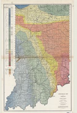
- Subject:
- Geographic Subject: Indiana and Topical Subject: Geology
- Creator:
- Indiana. Division of Geology
- Publisher:
- Indiana. Department of Conservation
- Date Created:
- 1932
- Identifier:
- VAC3073-M-00989
- Genre:
- Geological maps
- Geographic Location:
- Coordinates: W0870000 W0850000 N0410000 N0380000
- Related URL:
- Catalog URL: https://iucat.iu.edu/catalog/2849159
- Abstract:
- "Conservation Commission, Stanley Coulter, Chairman." "The based used...is the Ryse map, which has been modified." Includes geologic cros...
- Call Number:
- G4091.C5 1932 .I53
- Caption:
- Imprint: [Indianapolis] : Dept. of Conservation, State of Indiana, 1932.
- Physical Description:
- Dimensions: 177 x 112 cm and Scale: 1:253,440
- Alternate Identifier:
- Title Control Number: CAT7760BB
- Persistent URL:
- https://purl.dlib.indiana.edu/iudl/images/VAC3073/VAC3073-M-00989
-
- Subject:
- Geographic Subject: Bloomington (Ind.), Geographic Subject: Monroe County (Ind.), and Topical Subject: Census districts
- Creator:
- United States. Bureau of the Census
- Publisher:
- United States. Bureau of the Census
- Date Created:
- 1974
- Identifier:
- VAC3073-M-00892
- Genre:
- Census data and Thematic maps
- Geographic Location:
- Coordinates: W0864108 W0861902 N0392120 N0385926
- Related URL:
- Catalog URL: https://iucat.iu.edu/catalog/5300402
- Abstract:
- Blue line print. Shows 1970 census enumeration districts and census tracts for Bloomington, Ind. "Traced from map no. 68-A-8776." "70-...
- Call Number:
- G4094.B5 E25 1970 .U5
- Caption:
- Imprint: [Jeffersonville, Ind.] : Bureau of the Census, [1974?]
- Physical Description:
- Dimensions: 120 x 107 cm and Scale: 1:1,500
- Alternate Identifier:
- Title Control Number: a5300402
- Persistent URL:
- https://purl.dlib.indiana.edu/iudl/images/VAC3073/VAC3073-M-00892
-
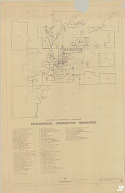
- Subject:
- Topical Subject: Boundaries, Topical Subject: Neighborhoods, Topical Subject: Community organization, Geographic Subject: Indianapolis (Ind.), and Geographic...
- Creator:
- Indianapolis (Ind.). Division of Planning & Zoning
- Publisher:
- [Dept. of Metropolitan Development, Division of Planning and Zoning?]
- Date Created:
- 1972
- Identifier:
- VAC3073-M-00889
- Genre:
- Thematic maps
- Geographic Location:
- Coordinates: W0861941 W0855614 N0395538 N0393755
- Related URL:
- Catalog URL: https://iucat.iu.edu/catalog/6289116
- Abstract:
- Blueline. Includes indexed list of neighborhood organizations.
- Call Number:
- G4093.M3 E6 1972 .I5
- Caption:
- Imprint: [Indianapolis?]: [Dept. of Metropolitan Development, Division of Planning and Zoning?], [1972?]
- Physical Description:
- Dimensions: 151 x 101 cm and Scale: 1:36,000
- Alternate Identifier:
- Title Control Number: a6289116
- Persistent URL:
- https://purl.dlib.indiana.edu/iudl/images/VAC3073/VAC3073-M-00889
-
- Subject:
- Geographic Subject: Indianapolis Metropolitan Area (Ind.) and Geographic Subject: Indianapolis (Ind.)
- Creator:
- Metro Graphic Arts
- Publisher:
- [publisher not identified]
- Date Created:
- 1975
- Identifier:
- VAC3073-M-00864
- Genre:
- Maps
- Geographic Location:
- Coordinates: W0861941 W0855614 N0395538 N0393755
- Related URL:
- Catalog URL: https://iucat.iu.edu/catalog/5322622
- Abstract:
- Plastic index device in pocket. Includes indexes, A-C of street index on attached sheet and "Inset map of adjacent areas in Johnson County."
- Call Number:
- G4094 .I4 1975 .M4
- Caption:
- Imprint: Grand Rapids, Mich. : [publisher not identified], 1975.
- Physical Description:
- Dimensions: 128 x 119 cm and Scale: 1:29,000
- Alternate Identifier:
- Title Control Number: a5322622
- Persistent URL:
- https://purl.dlib.indiana.edu/iudl/images/VAC3073/VAC3073-M-00864
-
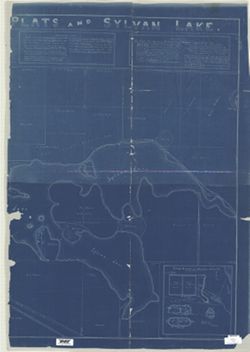
- Subject:
- Geographic Subject: Noble County (Ind.), Geographic Subject: Rome City (Ind.), Geographic Subject: Sylvan Lake (Ind.), Topical Subject: Real property, and To...
- Creator:
- Owen, M. F. (Millard Fillmore), 1851-1932
- Publisher:
- [M.F. Owen]
- Date Created:
- 1909
- Identifier:
- VAC3073-M-00846
- Genre:
- Cadastral maps
- Geographic Location:
- Coordinates: W0852308 W0851939 N0413011 N0412827
- Related URL:
- Catalog URL: https://iucat.iu.edu/catalog/4676408
- Abstract:
- Blueprint. Originally copied on 4 sheets. Includes text and insets: "Map of bluffs, bridges, wagon road and banks upon which Northport Feeder Dam was...
- Call Number:
- G4094 .R85G46 1909 .O94
- Caption:
- Imprint: [Rome City (Ind.)?] : [M.F. Owen], 1909.
- Physical Description:
- Dimensions: 125 x 177 cm, on sheets 133 x 93 and 129 x 93 cm and Scale: 1:2,700
- Alternate Identifier:
- Title Control Number: CAQ5632BB
- Persistent URL:
- https://purl.dlib.indiana.edu/iudl/images/VAC3073/VAC3073-M-00846
-
- Subject:
- Geographic Subject: Indiana
- Publisher:
- s.n.
- Identifier:
- VAC3073-M-00828
- Genre:
- Outline maps
- Related URL:
- Catalog URL: https://iucat.iu.edu/catalog/5044512
- Abstract:
- Blue line print. Title supplied by cataloger. Includes Indiana north of a line that includes Logansport and Peru, north from Township 27 North. Shows cou...
- Call Number:
- G4091 .A1 1900 .N67
- Caption:
- Imprint: [S.l. : s.n., 19--?]
- Physical Description:
- Dimensions: 178 x 91 cm and Scale: 1:126,720
- Alternate Identifier:
- Title Control Number: a5044512
- Persistent URL:
- https://purl.dlib.indiana.edu/iudl/images/VAC3073/VAC3073-M-00828
- Provenance:
- Northern Indiana base map
-
- Subject:
- Topical Subject: Election districts and Geographic Subject: Bloomington (Ind.)
- Creator:
- C.-M. Engineering
- Publisher:
- C.-M. Engineering
- Date Created:
- 1955
- Identifier:
- VAC3073-M-00795
- Genre:
- Thematic maps
- Geographic Location:
- Coordinates: W0863323 W0862823 N0391046 N0390854
- Related URL:
- Catalog URL: https://iucat.iu.edu/catalog/5300319
- Abstract:
- Blue line print. Appears to show election precincts within the Bloomington corporation limits. B-GEOMAP: Hand annotated in the spring of 1961 to show locat...
- Call Number:
- G4094.B5 F7 1955 .C175
- Caption:
- Imprint: Bloomington, Ind. : C.-M. Engineering, 1955.
- Physical Description:
- Scale: 1:3,500 and Dimensions: 103 x 132 cm
- Alternate Identifier:
- Title Control Number: a5300319
- Persistent URL:
- https://purl.dlib.indiana.edu/iudl/images/VAC3073/VAC3073-M-00795
-

- Subject:
- Topical Subject: Sewerage and Geographic Subject: Bloomington (Ind.)
- Creator:
- Bloomington (Ind.). Office of City Civil Engineer
- Publisher:
- [City of Bloomington?]
- Date Created:
- 1946
- Identifier:
- VAC3073-M-00706
- Genre:
- Thematic maps
- Geographic Location:
- Coordinates: W0863532 W0862816 N0391315 N0390716
- Related URL:
- Catalog URL: https://iucat.iu.edu/catalog/6946203
- Abstract:
- Blueprint. At head of title: Bloomington, Indiana.
- Call Number:
- G4094.B5N46 1946 .B56
- Caption:
- Imprint: [Bloomington, Ind.?] : [City of Bloomington?], [1946?]
- Physical Description:
- Scale: 1:3,900 and Dimensions: 105 x 131 cm
- Alternate Identifier:
- Title Control Number: a6946203
- Persistent URL:
- https://purl.dlib.indiana.edu/iudl/images/VAC3073/VAC3073-M-00706
-
- Subject:
- Topical Subject: Classification, Geographic Subject: Morgan County (Ind.), and Topical Subject: Soils
- Creator:
- Ulrich, H. P. (Herbert Paul), 1904-
- Publisher:
- United States. Bureau of Soils
- Date Created:
- 1937
- Identifier:
- VAC3073-M-00635
- Genre:
- Thematic maps
- Geographic Location:
- Coordinates: W0864100 W0861500 N0393800 N0392100
- Related URL:
- Catalog URL: https://iucat.iu.edu/catalog/4693743
- Abstract:
- Shows soils types classification by colors and symbols. "Surveyed in 1937. Series 1937." "Lith. a. Hoen & Co., Inc."
- Call Number:
- G4093 .M9J3 1937 .U47
- Caption:
- Imprint: [Washington, D.C.?] : The Bureau, [1937?]
- Physical Description:
- Scale: 1:63,360 and Dimensions: 137 x 161 cm, sheets 146 x 103 cm and 132 x 87 cm
- Alternate Identifier:
- Title Control Number: CAY8983BB
- Persistent URL:
- https://purl.dlib.indiana.edu/iudl/images/VAC3073/VAC3073-M-00635
-
- Subject:
- Topical Subject: Roads and Geographic Subject: Indiana
- Creator:
- Indiana. State Highway Commission (1961-1981). Division of Planning
- Publisher:
- Indiana. State Highway Commission (1961-1981). Division of Planning
- Date Created:
- 1971
- Identifier:
- VAC3073-M-00638
- Genre:
- Road maps
- Geographic Location:
- Coordinates: W0880700 W0844500 N0414500 N0375200
- Related URL:
- Catalog URL: https://iucat.iu.edu/catalog/5335907
- Abstract:
- Blue line print. "May 1, 1971." Includes inset of Indianapolis.
- Call Number:
- G4091.P2 1971 .I53
- Caption:
- Imprint: [Indianapolis?] : [The Division?], [1971?]
- Physical Description:
- Dimensions: 133 x 89 cm and Scale: 1:360,000
- Alternate Identifier:
- Title Control Number: a5335907
- Persistent URL:
- https://purl.dlib.indiana.edu/iudl/images/VAC3073/VAC3073-M-00638
-
- Subject:
- Geographic Subject: Muncie (Ind.)
- Creator:
- Hefel, Toney C.
- Publisher:
- E.P. Noll & Co.
- Date Created:
- 1891
- Identifier:
- VAC3073-M-00701
- Genre:
- Maps
- Geographic Location:
- Coordinates: W0852716 W0851914 N0401426 N0400856
- Related URL:
- Catalog URL: https://iucat.iu.edu/catalog/2789504
- Abstract:
- Includes advertisements from local businesses. Includes "Fire alarm boxes" locations.
- Call Number:
- G4094 .M9 1891 .H44
- Caption:
- Imprint: Philadelphia [Pa.] : E. P. Noll & Co., 1891.
- Physical Description:
- Dimensions: 107 x 137 cm, on sheet 128 x 166 cm and Scale: 1:4,800
- Alternate Identifier:
- Title Control Number: CAF2474BB
- Persistent URL:
- https://purl.dlib.indiana.edu/iudl/images/VAC3073/VAC3073-M-00701
-
- Subject:
- Topical Subject: Roads and Geographic Subject: Indiana
- Creator:
- H.M. Gousha Company
- Publisher:
- H.M. Gousha Company
- Date Created:
- 1946
- Identifier:
- VAC3073-M-00413
- Genre:
- Road maps
- Geographic Location:
- Coordinates: W0880500 W0844700 N0414500 N0374600
- Related URL:
- Catalog URL: https://iucat.iu.edu/catalog/5266639
- Abstract:
- Includes index to cities and towns. Text and ancillary maps of Chicago and vicinity, Hammond, Gary, Michigan City Region, South Bend, Indiana, Indianapolis...
- Call Number:
- G4091.P2 1946 .H2
- Caption:
- Imprint: Chicago : H.M. Gousha, [1946]
- Physical Description:
- Dimensions: 58 x 38 cm and Scale: 1:800,000
- Alternate Identifier:
- Title Control Number: a5266639
- Persistent URL:
- https://purl.dlib.indiana.edu/iudl/images/VAC3073/VAC3073-M-00413
-
- Subject:
- Geographic Subject: Bloomington (Ind.)
- Creator:
- Burton, G. E.
- Publisher:
- [S.l. : s.n., 1910?]
- Date Created:
- Circa 1910
- Identifier:
- VAC3073-M-01599
- Genre:
- Maps
- Related URL:
- Catalog URL: https://iucat.iu.edu/catalog/6753266
- Abstract:
- Relief shown by contours. "Topography by G. E. Burton." Includes building indexes.
- Call Number:
- G4094.B5 1910 .M37
- Physical Description:
- Dimensions: 32 x 34 cm and Scale: Approximately 1:9,387. 6 3/4 inches = 1 mile
- Persistent URL:
- https://purl.dlib.indiana.edu/iudl/images/VAC3073/VAC3073-M-01599
-
- Subject:
- Geographic Subject: Indiana and Geographic Subject: Ohio
- Creator:
- Bradford, T. G. (Thomas Gamaliel), 1802-1887
- Publisher:
- [Boston] : [American Stationers' Co.], [1835]
- Identifier:
- VAC3073-M-01598
- Geographic Location:
- Coordinates: W0880600 W0802800 N0415800 N0374500
- Related URL:
- Catalog URL: https://iucat.iu.edu/catalog/15471925
- Abstract:
- From Bradford, T.G., A comprehensive atlas, geographical, historical & commercial. Boston : American Stationers' Co., 1835. Shows state and county ...
- Call Number:
- G4090 1835 .B73
- Physical Description:
- Dimensions: 20 x 26 cm, on sheet 25 x 33 cm
- Persistent URL:
- https://purl.dlib.indiana.edu/iudl/images/VAC3073/VAC3073-M-01598
-
- Subject:
- Topical Subject: IGS Annual Reports, Topical Subject: Road materials, Topical Subject: Gravel, Topical Subject: Quarries and quarrying, and Geographic Subjec...
- Publisher:
- Indiana. Department of Geology and Natural Resources
- Date Created:
- 1906
- Identifier:
- VAC3073-M-01589
- Genre:
- Thematic maps
- Geographic Location:
- Coordinates: W0864109 W0861450 N0393801 N0392020
- Related URL:
- Catalog URL: https://iucat.iu.edu/catalog/18299115
- Abstract:
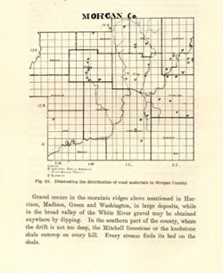
- Alternate title: Morgan Co. Title from caption. At head of title: Fig. 45. Detached from: The roads and road materials of a portion of southwestern Indian...
- Call Number:
- G4093.M9H5 1905 .M67
- Caption:
- Imprint: [Indianapolis] : [Indiana Dept. of Geology and Natural Resources], [1906]
- Physical Description:
- Scale: Approximately 1:366,300 and Dimensions: on sheet 17 x 14 cm
- Alternate Identifier:
- Alternate ID: 390726IP and Title Control Number: a18299115
- Persistent URL:
- https://purl.dlib.indiana.edu/iudl/images/VAC3073/VAC3073-M-01589
- Provenance:
- 30th Annual Report (1905) / Indiana. Department of Geology and Natural Resources.
-
- Subject:
- Geographic Subject: Huntingburg Region (Ind.), Topical Subject: Clay, Topical Subject: IGS Annual Reports, Geographic Subject: Dubois County (Ind.), and Topi...
- Creator:
- Blatchley, Raymond S. (Raymond Sillliman)
- Publisher:
- Indiana. Department of Geology and Natural Resources
- Date Created:
- 1905
- Identifier:
- VAC3073-M-01587
- Genre:
- Geological maps
- Geographic Location:
- Coordinates: W0865919 W0865616 N0381927 N0381621
- Related URL:
- Catalog URL: https://iucat.iu.edu/catalog/18282191
- Abstract:
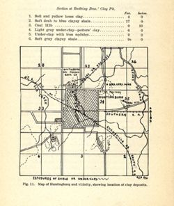
- Shows locations of clay deposits and local brick and tile companies. Also includes listings of measurements for the Bockting Bros.' clay pit. "Fig....
- Call Number:
- G4094.H8H5 1904 .M37
- Caption:
- Imprint: [Indianapolis] : [Wm. B. Burford], [1905] and Imprint: [Indianapolis] : [Indiana Department of Geology and Natural Resources], [1905]
- Physical Description:
- Scale: Approximately 1:46,650 and Dimensions: on sheet 17 x 14 cm
- Alternate Identifier:
- Alternate ID: 390726IP and Title Control Number: a18282191
- Persistent URL:
- https://purl.dlib.indiana.edu/iudl/images/VAC3073/VAC3073-M-01587
- Provenance:
- 29th Annual Report (1904) / Indiana. Department of Geology and Natural Resources.
-
- Subject:
- Geographic Subject: Brazil (Ind.), Topical Subject: IGS Annual Reports, Topical Subject: Clay industries, and Topical Subject: Clay
- Creator:
- Blatchley, Raymond S. (Raymond Sillliman)
- Publisher:
- Indiana. Department of Geology and Natural Resources
- Date Created:
- 1905
- Identifier:
- VAC3073-M-01586
- Genre:
- Geological maps
- Geographic Location:
- Coordinates: W0870852 W0870554 N0393212 N0393014
- Related URL:
- Catalog URL: https://iucat.iu.edu/catalog/18279473
- Abstract:
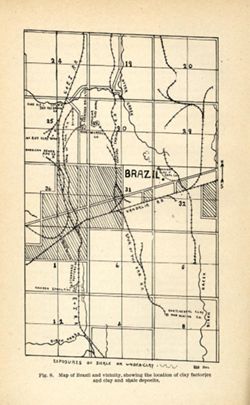
- Title from caption. "Fig. 8." "RSB DEL." Shows locations of clay deposits as well as mining, clay works, brick, and sewer pipe companies....
- Call Number:
- G4093.P2H5 1904 .B75
- Caption:
- Imprint: [Indianapolis] : [Wm. B. Burford], [1905] and Imprint: [Indianapolis] : [Indiana Department of Geology and Natural Resources], [1905]
- Physical Description:
- Scale: Approximately 1:46,650 and Dimensions: on sheet 22 x 14 cm
- Alternate Identifier:
- Title Control Number: a18279473 and Alternate ID: 390726IP
- Persistent URL:
- https://purl.dlib.indiana.edu/iudl/images/VAC3073/VAC3073-M-01586
- Provenance:
- 29th Annual Report (1904) / Indiana. Department of Geology and Natural Resources.
-
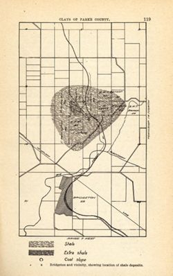
- Subject:
- Geographic Subject: Bridgeton Region (Ind.), Topical Subject: Mines and mineral resources, Geographic Subject: Parke County (Ind.), Topical Subject: IGS Annu...
- Publisher:
- Indiana. Department of Geology and Natural Resources
- Date Created:
- 1905
- Identifier:
- VAC3073-M-01585
- Genre:
- Geological maps
- Geographic Location:
- Coordinates: W0871115 W0870900 N0394130 N0393800
- Related URL:
- Catalog URL: https://iucat.iu.edu/catalog/18279221
- Abstract:
- Shows location of shale, extra shale, and coal slope. "Clays of Parke County." Detached from: The clays and clay industries of Indiana / W. S. B...
- Call Number:
- G4093.P2H5 1904 .B75
- Caption:
- Imprint: [Indianapolis] : [Indiana Department of Geology and Natural Resources], [1905] and Imprint: [Indianapolis] : [Wm. B. Burford], [1905]
- Physical Description:
- Scale: Scale not given. and Dimensions: on sheet 22 x 14 cm
- Alternate Identifier:
- Alternate ID: 390726IP and Title Control Number: a18279221
- Persistent URL:
- https://purl.dlib.indiana.edu/iudl/images/VAC3073/VAC3073-M-01585
- Provenance:
- 29th Annual Report (1904) / Indiana. Department of Geology and Natural Resources.
-
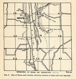
- Subject:
- Geographic Subject: Mecca Region (Ind.), Topical Subject: Clay, Topical Subject: Clay industries, Topical Subject: Shale, Geographic Subject: Parke County (I...
- Creator:
- Blatchley, Raymond S. (Raymond Sillliman)
- Publisher:
- Indiana. Department of Geology and Natural Resources
- Date Created:
- 1905
- Identifier:
- VAC3073-M-01584
- Genre:
- Geological maps
- Geographic Location:
- Coordinates: W0872106 W0871741 N0394423 N0394217
- Related URL:
- Catalog URL: https://iucat.iu.edu/catalog/18282202
- Abstract:
- Title from caption. Shows locations of shale and clay deposits, clay mines, and local brick and clay works companies. Also includes listing of measurements f...
- Call Number:
- G4093.P2H5 1904 .M37
- Caption:
- Imprint: [Indianapolis] : [Indiana Department of Geology and Natural Resources ], [1905] and Imprint: [Indianapolis] : [Wm. B. Burford], [1905]
- Physical Description:
- Dimensions: on sheet 12 x 12 cm and Scale: Approximately 1:46,650
- Alternate Identifier:
- Alternate ID: 390726IP and Title Control Number: a18282202
- Persistent URL:
- https://purl.dlib.indiana.edu/iudl/images/VAC3073/VAC3073-M-01584
- Provenance:
- 29th Annual Report (1904) / Indiana. Department of Geology and Natural Resources.
-
![Map No. 4 showing locations of upper & lower dams [Winona Lake Region, Indiana]](https://iiif.uits.iu.edu/iiif/2/3j3345867%2Ffiles%2Fcfcf70eb-0483-44d3-b9ee-e305909b40f2/full/250,/0/default.jpg)
- Subject:
- Geographic Subject: Kosciusko County (Ind.), Geographic Subject: Winona Lake Region (Ind. : Lake), Topical Subject: IGS Annual Reports, and Topical Subject: ...
- Publisher:
- Indiana. Department of Geology and Natural Resources
- Date Created:
- 1904
- Identifier:
- VAC3073-M-01583
- Genre:
- Topographic maps and Geological cross-sections
- Geographic Location:
- Coordinates: W0855154 W0855032 N0411406 N0411308
- Related URL:
- Catalog URL: https://iucat.iu.edu/catalog/18418357
- Abstract:
- Relief shown by contours and profile. Shows location of dams on Winona Lake outlet near Warsaw in Kosciusko County, Indiana, and cross-sections of upper and ...
- Call Number:
- G4093.K6N2 1903 .M3
- Caption:
- Imprint: [Indianapolis] : [Wm. B. Burford], [1904] and Imprint: [Indianapolis] : [Indiana Department of Geology and Natural Resources], [1904]
- Physical Description:
- Dimensions: on sheet 10 x 10 cm and Scale: Approximately 1:20,100. Vertical scale varies
- Alternate Identifier:
- Title Control Number: a18418357 and Alternate ID: 390726IP
- Persistent URL:
- https://purl.dlib.indiana.edu/iudl/images/VAC3073/VAC3073-M-01583
- Provenance:
- 28th Annual Report (1903) / Indiana. Department of Geology and Natural Resources.
-
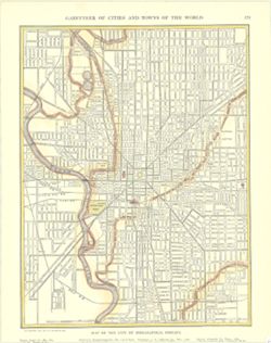
- Subject:
- Geographic Subject: Indianapolis (Ind.)
- Publisher:
- [New York] : P. F. Collier & Son, 1911.
- Identifier:
- VAC3073-M-01582
- Genre:
- Maps
- Geographic Location:
- Coordinates: W0861142 W0860735 N0394758 N0394409
- Related URL:
- Catalog URL: https://iucat.iu.edu/catalog/15471922
- Abstract:
- Shows states and principal cities indexed in margin. Inset maps show Hamburg and Berlin. Shows cities, towns, and railroads. "Copyright, 1911, by P....
- Call Number:
- G4094.I4 1911.C65
- Physical Description:
- Dimensions: 30 x 23 cm
- Persistent URL:
- https://purl.dlib.indiana.edu/iudl/images/VAC3073/VAC3073-M-01582
-
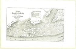
- Subject:
- Geographic Subject: Cannelton (Ind.)
- Publisher:
- [Indianapolis] : [E. Chamberlain], [1850]
- Date Created:
- 1850
- Identifier:
- VAC3073-M-01581
- Related URL:
- Catalog URL: https://iucat.iu.edu/catalog/15471928
- Abstract:
- Relief shown by hachures. From Indiana gazetteer, or topographical dictionary of the state of Indiana. Indianapolis : E. Chamberlain, 1850. Shows Cannelt...
- Call Number:
- G4094.C22 1850 .F85
- Physical Description:
- Scale: 1:24,000 and Dimensions: 9 x 15 cm
- Persistent URL:
- https://purl.dlib.indiana.edu/iudl/images/VAC3073/VAC3073-M-01581
-
- Subject:
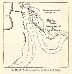
- Topical Subject: IGS Annual Reports, Geographic Subject: Cherry Creek (Ind.), and Topical Subject: Rivers
- Publisher:
- Indiana. Department of Geology and Natural Resources
- Date Created:
- 1904
- Identifier:
- VAC3073-M-01580
- Genre:
- Maps
- Related URL:
- Catalog URL: new.iucat.iu.edu/catalog/4022271
- Call Number:
- QE109 .A2 1903
- Caption:
- Imprint: Indianapolis : 1904.
- Persistent URL:
- https://purl.dlib.indiana.edu/iudl/images/VAC3073/VAC3073-M-01580
- Provenance:
- 28th Annual Report (1903) / Indiana. Department of Geology and Natural Resources.
-
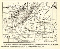
- Subject:
- Geographic Subject: Indiana, Topical Subject: Moraines, Geographic Subject: Ohio, and Topical Subject: IGS Annual Reports
- Creator:
- Dryer, Charles Redway, 1850-1927
- Publisher:
- Indiana. Department of Geology and Natural Resources
- Date Created:
- 1904
- Identifier:
- VAC3073-M-01578
- Genre:
- Geological maps
- Geographic Location:
- Coordinates: W0860630 W0832600 N0415400 N0401530
- Related URL:
- Catalog URL: https://iucat.iu.edu/catalog/18418361
- Abstract:
- Caption title: Glacial map showing moraines in which Lake Eagle and the city of Warsaw are located. Relief shown by profile. Includes geological profile of r...
- Call Number:
- QE109 .A2 1903
- Caption:
- Imprint: [Indianapolis] : [Wm. B. Burford], [1904] and Imprint: [Indianapolis] : [Indiana Department of Geology and Natural Resources], [1904]
- Physical Description:
- Dimensions: 8 x 11 cm and Scale: Approximately 1:2,476,000. Vertical scale indeterminable
- Alternate Identifier:
- Alternate ID: 390726IP and Title Control Number: a18418361
- Persistent URL:
- https://purl.dlib.indiana.edu/iudl/images/VAC3073/VAC3073-M-01578
- Provenance:
- 28th Annual Report (1903) / Indiana. Department of Geology and Natural Resources.
-
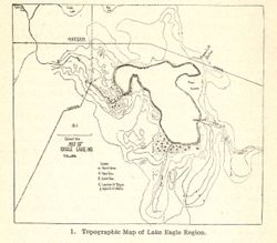
- Subject:
- Topical Subject: Lakes, Geographic Subject: Winona Lake (Ind. : Lake), Geographic Subject: Warsaw (Ind.), and Topical Subject: IGS Annual Reports
- Publisher:
- Indiana. Department of Geology and Natural Resources
- Date Created:
- 1904
- Identifier:
- VAC3073-M-01577
- Genre:
- Topographic maps
- Related URL:
- Catalog URL: new.iucat.iu.edu/catalog/4022271
- Call Number:
- QE109 .A2 1903
- Caption:
- Imprint: Indianapolis : 1904.
- Persistent URL:
- https://purl.dlib.indiana.edu/iudl/images/VAC3073/VAC3073-M-01577
- Provenance:
- 28th Annual Report (1903) / Indiana. Department of Geology and Natural Resources.
-
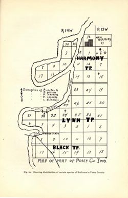
- Subject:
- Topical Subject: IGS Annual Reports, Geographic Subject: New Harmony (Ind.), and Geographic Subject: Posey County (Ind.)
- Publisher:
- Indiana. Department of Geology and Natural Resources
- Date Created:
- 1903
- Identifier:
- VAC3073-M-01576
- Genre:
- Thematic maps
- Related URL:
- Catalog URL: new.iucat.iu.edu/catalog/4022271
- Call Number:
- QE109 .A2 1902
- Caption:
- Imprint: Indianapolis : 1903.
- Physical Description:
- Scale: Scale not given.
- Persistent URL:
- https://purl.dlib.indiana.edu/iudl/images/VAC3073/VAC3073-M-01576
-
- Subject:
- Geographic Subject: Indiana and Topical Subject: IGS Annual Reports
- Publisher:
- Indiana. Department of Geology and Natural Resources
- Date Created:
- 1902
- Identifier:
- VAC3073-M-01575
- Genre:
- Index maps
- Geographic Location:
- Coordinates: W0880500 W0844700 N0414500 N0374600
- Related URL:
- Catalog URL: https://iucat.iu.edu/catalog/18418335
- Abstract:
- Index map showing locations covered by topographic maps represented on plates II-IV of the article. Shading indicates area covered by Topographic Section (Pl...
- Call Number:
- G4090 1901 .S5
- Caption:
- Imprint: [Indianapolis] : [Indiana Department of Geology and Natural Resources], [1902] and Imprint: [Indianapolis] : [Wm. B. Burford], [1902]
- Physical Description:
- Scale: Approximately 1:2,299,000 and Dimensions: on sheet 22 x 15 cm
- Alternate Identifier:
- Title Control Number: a18418335 and Alternate ID: 390726IP
- Persistent URL:
- https://purl.dlib.indiana.edu/iudl/images/VAC3073/VAC3073-M-01575
- Provenance:
- 26th Annual Report (1901) / Indiana. Department of Geology and Natural Resources.
-
- Subject:
- Geographic Subject: Indiana, Topical Subject: IGS Annual Reports, and Topical Subject: Orthoptera--Collection and preservation
- Creator:
- Blatchley, W. S. (Willis Stanley), 1859-1940
- Publisher:
- Indiana. Department of Geology and Natural Resources
- Date Created:
- 1903
- Identifier:
- VAC3073-M-01574
- Genre:
- Thematic maps
- Geographic Location:
- Coordinates: W0880500 W0844700 N0414500 N0374600
- Related URL:
- Catalog URL: https://iucat.iu.edu/catalog/18418335
- Abstract:
- At head of title: "Fig. 1." Detached from: The Orthoptera of Indiana / by W. S. Blatchley. In Indiana Department of Geology and Natural Resource...
- Call Number:
- G4091.D4 1902 .B5
- Caption:
- Imprint: Indianapolis : Wm. B. Burford, [1903] and Imprint: [Indianapolis] : [Indiana Department of Geology and Natural Resouces], [1903]
- Physical Description:
- Scale: Approximately 1:2,850,000
- Alternate Identifier:
- Title Control Number: a18418335
- Persistent URL:
- https://purl.dlib.indiana.edu/iudl/images/VAC3073/VAC3073-M-01574
- Provenance:
- 27th Annual Report (1902) / Indiana. Department of Geology and Natural Resources.
-
- Subject:
- Topical Subject: Watersheds and Geographic Subject: Indiana
- Creator:
- Call, Richard Ellsworth, 1856-1917
- Publisher:
- Indiana. Department of Geology and Natural Resources
- Date Created:
- 1900
- Identifier:
- VAC3073-M-01572
- Genre:
- Maps
- Geographic Location:
- Coordinates: W0880500 W0844700 N0414500 N0374600
- Related URL:
- Catalog URL: https://iucat.iu.edu/catalog/18418197
- Abstract:
- At foot of map: "Hydrographic map." At head of map: "Plate 1 -- Call, On Indiana mollusca." Detached from: A descriptive illustrated cata...
- Call Number:
- G4091.C315 1896 .C3
- Caption:
- Imprint: [Indianapolis] : [Department of Geology and Natural Resources], [1900] and Imprint: [Indianapolis] : [Wm. B. Burford], [1900]
- Physical Description:
- Dimensions: on sheet 22 x 15 cm and Scale: Approximately 1:1,267,200. 1 inch = 20 miles
- Alternate Identifier:
- Alternate ID: 390726IP and Title Control Number: a18418197
- Persistent URL:
- https://purl.dlib.indiana.edu/iudl/images/VAC3073/VAC3073-M-01572
- Provenance:
- 24th Annual Report (1899) / Indiana. Department of Geology and Natural Resources.
-
- Subject:
- Topical Subject: Mines and mineral resources, Geographic Subject: Indiana, Topical Subject: IGS Annual Reports, and Topical Subject: Geology, Stratigraphic
- Creator:
- Cubberley, Ellwood P., 1868-1941
- Publisher:
- Indiana. Department of Geology and Natural Resources
- Date Created:
- 1894
- Identifier:
- VAC3073-M-01571
- Genre:
- Geological cross-sections
- Geographic Location:
- Coordinates: W0873400 W0870100 N0414000 N0383900
- Related URL:
- Catalog URL: https://iucat.iu.edu/catalog/18224924
- Abstract:
- Geological cross section showing stratigraphy of mineral resources, including various coal, limestone, and shale layers. Relative relief in relation to sea l...
- Call Number:
- G4091.C57 1893 .C83, no. 16
- Caption:
- Imprint: Indpls : lithographed by William B. Burford, [1894] and Imprint: [Indianapolis] : [Indiana, Dept. of Geology and Natural Resources], [1894]
- Physical Description:
- Dimensions: 15 x 23 cm and Scale: Approximately 1:1,900,800. 30 miles to the inch. Vertical scale approximately 1:6,000. 500 feet to the inch
- Alternate Identifier:
- Alternate ID: 390726IP and Title Control Number: a18224924
- Persistent URL:
- https://purl.dlib.indiana.edu/iudl/images/VAC3073/VAC3073-M-01571
- Provenance:
- 18th Annual Report (1893) / Indiana. Department of Geology and Natural Resources.
-
- Subject:
- Topical Subject: IGS Annual Reports, Geographic Subject: Indiana, Topical Subject: Geology, Stratigraphic, and Topical Subject: Mines and mineral resources
- Creator:
- Cubberley, Ellwood P., 1868-1941
- Publisher:
- Indiana. Department of Geology and Natural Resources
- Date Created:
- 1894
- Identifier:
- VAC3073-M-01570
- Genre:
- Geological cross-sections
- Geographic Location:
- Coordinates: W0870500 W0860300 N0414000 N0380000
- Related URL:
- Catalog URL: https://iucat.iu.edu/catalog/18224924
- Abstract:
- Geological cross section showing stratigraphy of mineral resources, including various limestone and shale layers. Relative relief in relation to sea level sh...
- Call Number:
- G4091.C57 1893 .C83, no. 15
- Caption:
- Imprint: Indpls : lithographed by William B. Burford, [1894] and Imprint: [Indianapolis] : [Indiana, Dept. of Geology and Natural Resources], [1894]
- Physical Description:
- Scale: Approximately 1:1,900,800. 30 miles to the inch. Vertical scale approximately 1:6,000. 500 feet to the inch and Dimensions: 15 x 23 cm
- Alternate Identifier:
- Alternate ID: 390726IP and Title Control Number: a18224924
- Persistent URL:
- https://purl.dlib.indiana.edu/iudl/images/VAC3073/VAC3073-M-01570
- Provenance:
- 18th Annual Report (1893) / Indiana. Department of Geology and Natural Resources.
-
- Subject:
- Geographic Subject: Indiana, Topical Subject: Mines and mineral resources, Topical Subject: Geology, Stratigraphic, and Topical Subject: IGS Annual Reports
- Creator:
- Cubberley, Ellwood P., 1868-1941
- Publisher:
- Indiana. Department of Geology and Natural Resources
- Date Created:
- 1894
- Identifier:
- VAC3073-M-01569
- Genre:
- Geological cross-sections
- Geographic Location:
- Coordinates: W0870605 W0845021 N0413930 N0390428
- Related URL:
- Catalog URL: https://iucat.iu.edu/catalog/18224921
- Abstract:
- Geological cross section showing stratigraphy of mineral resources, including various limestone and shale layers. Relative relief in relation to sea level sh...
- Call Number:
- G4091.C57 1893 .C83, no. 5
- Caption:
- Imprint: Indpls : lithographed by William B. Burford, [1894] and Imprint: [Indianapolis] : [Indiana, Dept. of Geology and Natural Resources], [1894]
- Physical Description:
- Scale: Approximately 1:1,900,800. 30 miles to the inch. Vertical scale approximately 1:6,000. 500 feet to the inch and Dimensions: 15 x 23 cm
- Alternate Identifier:
- Title Control Number: a18224921 and Alternate ID: 390726IP
- Persistent URL:
- https://purl.dlib.indiana.edu/iudl/images/VAC3073/VAC3073-M-01569
- Provenance:
- 18th Annual Report (1893) / Indiana. Department of Geology and Natural Resources.
-
- Subject:
- Topical Subject: IGS Annual Reports, Topical Subject: Mines and mineral resources, Geographic Subject: Indiana, and Topical Subject: Geology, Stratigraphic
- Creator:
- Cubberley, Ellwood P., 1868-1941
- Publisher:
- Indiana. Department of Geology and Natural Resources
- Date Created:
- 1894
- Identifier:
- VAC3073-M-01568
- Genre:
- Geological cross-sections
- Geographic Location:
- Coordinates: W0862100 W0844815 N0414545 N0400900
- Related URL:
- Catalog URL: https://iucat.iu.edu/catalog/18224917
- Abstract:
- Geological cross section showing stratigraphy of mineral resources, including various limestone and shale layers. Relative relief in relation to sea level sh...
- Call Number:
- G4091.C57 1893 .C83, no. 4
- Caption:
- Imprint: [Indianapolis] : [Indiana, Dept. of Geology and Natural Resources], [1894] and Imprint: Indpls : lithographed by William B. Burford, [1894]
- Physical Description:
- Scale: Approximately 1:1,900,800. 30 miles to the inch. Vertical scale approximately 1:6,000. 500 feet to the inch and Dimensions: 15 x 23 cm
- Alternate Identifier:
- Alternate ID: 390726IP and Title Control Number: a18224917
- Persistent URL:
- https://purl.dlib.indiana.edu/iudl/images/VAC3073/VAC3073-M-01568
- Provenance:
- 18th Annual Report (1893) / Indiana. Department of Geology and Natural Resources.
-
- Subject:
- Topical Subject: Geology, Stratigraphic, Geographic Subject: Indiana, Topical Subject: Mines and mineral resources, and Topical Subject: IGS Annual Reports
- Creator:
- Cubberley, Ellwood P., 1868-1941
- Publisher:
- Indiana. Department of Geology and Natural Resources
- Date Created:
- 1894
- Identifier:
- VAC3073-M-01567
- Genre:
- Geological cross-sections
- Geographic Location:
- Coordinates: W0861818 W0854806 N0414542 N0381622
- Related URL:
- Catalog URL: https://iucat.iu.edu/catalog/18224912
- Abstract:
- Geological cross section showing stratigraphy of mineral resources, including various limestone and shale layers. Relative relief in relation to sea level sh...
- Call Number:
- G4091.C57 1893 .C83, no. 14
- Caption:
- Imprint: [Indianapolis] : [Indiana, Dept. of Geology and Natural Resources], [1894] and Imprint: Indpls : lithographed by William B. Burford, [1894]
- Physical Description:
- Dimensions: 15 x 23 cm and Scale: Approximately 1:1,900,800. 30 miles to the inch. Vertical scale approximately 1:6,000. 500 feet to the inch
- Alternate Identifier:
- Title Control Number: a18224912 and Alternate ID: 390726IP
- Persistent URL:
- https://purl.dlib.indiana.edu/iudl/images/VAC3073/VAC3073-M-01567
- Provenance:
- 18th Annual Report (1893) / Indiana. Department of Geology and Natural Resources.
-
- Subject:
- Topical Subject: Geology, Stratigraphic, Topical Subject: Mines and mineral resources, Topical Subject: IGS Annual Reports, and Geographic Subject: Indiana
- Creator:
- Cubberley, Ellwood P., 1868-1941
- Publisher:
- Indiana. Department of Geology and Natural Resources
- Date Created:
- 1894
- Identifier:
- VAC3073-M-01566
- Genre:
- Geological cross-sections
- Geographic Location:
- Coordinates: W0873200 W0844900 N0395000 N0394500
- Related URL:
- Catalog URL: https://iucat.iu.edu/catalog/18224850
- Abstract:
- Geological cross section showing stratigraphy of mineral resources, including various coal, limestone, and shale layers. Relative relief in relation to sea l...
- Call Number:
- G4091.C57 1893 .C83, no. 10
- Caption:
- Imprint: Indpls : lithographed by William B. Burford, [1894] and Imprint: [Indianapolis] : [Indiana, Dept. of Geology and Natural Resources], [1894]
- Physical Description:
- Scale: Approximately 1:1,900,800. 30 miles to the inch. Vertical scale approximately 1:6,000. 500 feet to the inch and Dimensions: 15 x 23 cm
- Alternate Identifier:
- Title Control Number: a18224850 and Alternate ID: 390726IP
- Persistent URL:
- https://purl.dlib.indiana.edu/iudl/images/VAC3073/VAC3073-M-01566
- Provenance:
- 18th Annual Report (1893) / Indiana. Department of Geology and Natural Resources.
-
- Subject:
- Topical Subject: Mines and mineral resources, Topical Subject: IGS Annual Reports, Geographic Subject: Indiana, and Topical Subject: Geology, Stratigraphic
- Creator:
- Cubberley, Ellwood P., 1868-1941
- Publisher:
- Indiana. Department of Geology and Natural Resources
- Date Created:
- 1894
- Identifier:
- VAC3073-M-01565
- Genre:
- Geological cross-sections
- Geographic Location:
- Coordinates: W0860745 W0844830 N0395315 N0375945
- Related URL:
- Catalog URL: https://iucat.iu.edu/catalog/18224846
- Abstract:
- Geological cross section showing stratigraphy of mineral resources, including various coal, limestone, and shale layers. Relative relief in relation to sea l...
- Call Number:
- G4091.C57 1893 .C83, no. 3
- Caption:
- Imprint: [Indianapolis] : [Indiana, Dept. of Geology and Natural Resources], [1894] and Imprint: Indpls : lithographed by William B. Burford, [1894]
- Physical Description:
- Scale: Approximately 1:1,900,800. 30 miles to the inch. Vertical scale approximately 1:6,000. 500 feet to the inch and Dimensions: 15 x 23 cm
- Alternate Identifier:
- Alternate ID: 390726IP and Title Control Number: a18224846
- Persistent URL:
- https://purl.dlib.indiana.edu/iudl/images/VAC3073/VAC3073-M-01565
- Provenance:
- 18th Annual Report (1893) / Indiana. Department of Geology and Natural Resources.
-
- Subject:
- Topical Subject: Mines and mineral resources, Geographic Subject: Indiana, Geographic Subject: Kentucky, Topical Subject: Geology, Stratigraphic, and Topical...
- Creator:
- Cubberley, Ellwood P., 1868-1941
- Publisher:
- Indiana. Department of Geology and Natural Resources
- Date Created:
- 1894
- Identifier:
- VAC3073-M-01564
- Genre:
- Geological cross-sections
- Geographic Location:
- Coordinates: W0873200 W0844900 N0404600 N0381000
- Related URL:
- Catalog URL: https://iucat.iu.edu/catalog/18189045
- Abstract:
- Geological cross section showing stratigraphy of mineral resources, including various limestone and shale layers. Relative relief in relation to sea level sh...
- Call Number:
- G4091.C57 1893 .C83, no. 6
- Caption:
- Imprint: [Indianapolis] : [Indiana, Dept. of Geology and Natural Resources], [1894] and Imprint: Indpls : lithographed by William B. Burford, [1894]
- Physical Description:
- Dimensions: 15 x 23 cm and Scale: Approximately 1:1,900,800. 30 miles to the inch. Vertical scale approximately 1:6,000. 500 feet to the inch
- Alternate Identifier:
- Title Control Number: a18189045 and Alternate ID: 390726IP
- Persistent URL:
- https://purl.dlib.indiana.edu/iudl/images/VAC3073/VAC3073-M-01564
- Provenance:
- 18th Annual Report (1893) / Indiana. Department of Geology and Natural Resources.
-
- Subject:
- Topical Subject: Mines and mineral resources, Topical Subject: Geology, Stratigraphic, Topical Subject: IGS Annual Reports, and Geographic Subject: Indiana
- Creator:
- Cubberley, Ellwood P., 1868-1941
- Publisher:
- Indiana. Department of Geology and Natural Resources
- Date Created:
- 1894
- Identifier:
- VAC3073-M-01563
- Genre:
- Geological cross-sections
- Geographic Location:
- Coordinates: W0873148 W0844819 N0403259 N0401126
- Related URL:
- Catalog URL: https://iucat.iu.edu/catalog/18188985
- Abstract:
- Geological cross section showing stratigraphy of mineral resources, including various coal, limestone, and shale layers. Relative relief in relation to sea l...
- Call Number:
- G4091.C57 1893 .C83, no. 9
- Caption:
- Imprint: Indpls : lithographed by William B. Burford, [1894] and Imprint: [Indianapolis] : [Indiana, Dept. of Geology and Natural Resources], [1894]
- Physical Description:
- Dimensions: 15 x 23 cm and Scale: Approximately 1:1,900,800. 30 miles to the inch. Vertical scale approximately 1:6,000. 500 feet to the inch
- Alternate Identifier:
- Title Control Number: a18188985 and Alternate ID: 390726IP
- Persistent URL:
- https://purl.dlib.indiana.edu/iudl/images/VAC3073/VAC3073-M-01563
- Provenance:
- 18th Annual Report (1893) / Indiana. Department of Geology and Natural Resources.
-
- Subject:
- Geographic Subject: Ohio, Geographic Subject: Indiana, Topical Subject: IGS Annual Reports, Topical Subject: Geology, Stratigraphic, Topical Subject: Mines a...
- Creator:
- Cubberley, Ellwood P., 1868-1941
- Publisher:
- Indiana. Department of Geology and Natural Resources
- Date Created:
- 1894
- Identifier:
- VAC3073-M-01562
- Genre:
- Geological cross-sections
- Geographic Location:
- Coordinates: W0880700 W0842800 N0390700 N0384100
- Related URL:
- Catalog URL: https://iucat.iu.edu/catalog/18188969
- Abstract:
- Geological cross section showing stratigraphy of mineral resources, including various coal, limestone, and shale layers. Relative relief in relation to sea l...
- Call Number:
- QE109 .A2
- Caption:
- Imprint: [Indianapolis] : [Indiana, Dept. of Geology and Natural Resources], [1894] and Imprint: Indpls : lithographed by William B. Burford, [1894]
- Physical Description:
- Scale: Approximately 1:1,900,800. 30 miles to the inch. Vertical scale approximately 1:6,000. 500 feet to the inch and Dimensions: 15 x 23 cm
- Alternate Identifier:
- Title Control Number: a18188969 and Alternate ID: 390726IP
- Persistent URL:
- https://purl.dlib.indiana.edu/iudl/images/VAC3073/VAC3073-M-01562
- Provenance:
- 18th Annual Report (1893) / Indiana. Department of Geology and Natural Resources.
-
- Subject:
- Topical Subject: IGS Annual Reports, Geographic Subject: Indiana, Topical Subject: Geology, Stratigraphic, and Topical Subject: Mines and mineral resources
- Creator:
- Cubberley, Ellwood P., 1868-1941
- Publisher:
- Indiana. Department of Geology and Natural Resources
- Date Created:
- 1894
- Identifier:
- VAC3073-M-01561
- Genre:
- Geological cross-sections
- Geographic Location:
- Coordinates: W0850606 W0844724 N0414550 N0390449
- Related URL:
- Catalog URL: https://iucat.iu.edu/catalog/18188961
- Abstract:
- Geological cross section showing stratigraphy of mineral resources, including various limestone and shale layers. Relative relief in relation to sea level sh...
- Call Number:
- G4091.C57 1893 .C83, no. 12
- Caption:
- Imprint: Indpls : lithographed by William B. Burford, [1894] and Imprint: [Indianapolis] : [Indiana, Dept. of Geology and Natural Resources], [1894]
- Physical Description:
- Scale: Approximately 1:1,900,800. 30 miles to the inch. Vertical scale approximately 1:6,000. 500 feet to the inch and Dimensions: 15 x 23 cm
- Alternate Identifier:
- Title Control Number: a18188961 and Alternate ID: 390726IP
- Persistent URL:
- https://purl.dlib.indiana.edu/iudl/images/VAC3073/VAC3073-M-01561
- Provenance:
- 18th Annual Report (1893) / Indiana. Department of Geology and Natural Resources.
-
- Subject:
- Topical Subject: Geology, Stratigraphic, Geographic Subject: Indiana, Geographic Subject: Ohio, Topical Subject: Mines and mineral resources, and Topical Sub...
- Creator:
- Cubberley, Ellwood P., 1868-1941
- Publisher:
- Indiana. Department of Geology and Natural Resources
- Date Created:
- 1894
- Identifier:
- VAC3073-M-01560
- Genre:
- Geological cross-sections
- Geographic Location:
- Coordinates: W0873100 W0835800 N0413500 N0404200
- Related URL:
- Catalog URL: https://iucat.iu.edu/catalog/18188874
- Abstract:
- Geological cross section showing stratigraphy of mineral resources, including various limestone and shale layers. Relative relief in relation to sea level sh...
- Call Number:
- G4091.C57 1893 .C83, no. 7
- Caption:
- Imprint: Indpls : lithographed by William B. Burford, [1894] and Imprint: [Indianapolis] : [Indiana, Dept. of Geology and Natural Resources], [1894]
- Physical Description:
- Dimensions: 15 x 23 cm and Scale: Approximately 1:1,900,800. 30 miles to the inch. Vertical scale approximately 1:6,000. 500 feet to the inch
- Alternate Identifier:
- Title Control Number: a18188874 and Alternate ID: 390726IP
- Persistent URL:
- https://purl.dlib.indiana.edu/iudl/images/VAC3073/VAC3073-M-01560
- Provenance:
- 18th Annual Report (1893) / Indiana. Department of Geology and Natural Resources.
-
- Subject:
- Topical Subject: Geology, Stratigraphic, Geographic Subject: Indiana, Topical Subject: Mines and mineral resources, and Topical Subject: IGS Annual Reports
- Creator:
- Cubberley, Ellwood P., 1868-1941
- Publisher:
- Indiana. Department of Geology and Natural Resources
- Date Created:
- 1894
- Identifier:
- VAC3073-M-01559
- Genre:
- Geological cross-sections
- Geographic Location:
- Coordinates: W0873300 W0844700 N0405000 N0404400
- Related URL:
- Catalog URL: https://iucat.iu.edu/catalog/18175184
- Abstract:
- Geological cross section showing stratigraphy of mineral resources, including various limestone and shale layers. Relative relief in relation to sea level sh...
- Call Number:
- G4091.C57 1893 .C83, no. 8
- Caption:
- Imprint: Indpls : lithographed by William B. Burford, [1894] and Imprint: [Indianapolis] : [Indiana, Dept. of Geology and Natural Resources], [1894]
- Physical Description:
- Scale: Approximately 1:1,900,800. 30 miles to the inch. Vertical scale approximately 1:6,000. 500 feet to the inch and Dimensions: 15 x 23 cm
- Alternate Identifier:
- Alternate ID: 390726IP and Title Control Number: a18175184
- Persistent URL:
- https://purl.dlib.indiana.edu/iudl/images/VAC3073/VAC3073-M-01559
- Provenance:
- 18th Annual Report (1893) / Indiana. Department of Geology and Natural Resources.
-
- Subject:
- Geographic Subject: Indiana, Topical Subject: Mines and mineral resources, Topical Subject: Geology, Stratigraphic, Topical Subject: IGS Annual Reports, and ...
- Creator:
- Cubberley, Ellwood P., 1868-1941
- Publisher:
- Indiana. Department of Geology and Natural Resources
- Date Created:
- 1894
- Identifier:
- VAC3073-M-01558
- Genre:
- Geological cross-sections
- Geographic Location:
- Coordinates: W0873300 W0835800 N0413500 N0392600
- Related URL:
- Catalog URL: https://iucat.iu.edu/catalog/18175093
- Abstract:
- Geological cross section showing stratigraphy of mineral resources, including various limestone and shale layers. Relative relief in relation to sea level sh...
- Call Number:
- G4091.C57 1893 .C83, no. 1
- Caption:
- Imprint: Indpls : lithographed by William B. Burford, [1894] and Imprint: [Indianapolis] : [Indiana, Dept. of Geology and Natural Resources], [1894]
- Physical Description:
- Scale: Approximately 1:1,900,800. 30 miles to the inch. Vertical scale approximately 1:6,000. 500 feet to the inch and Dimensions: 15 x 23 cm
- Alternate Identifier:
- Alternate ID: 390726IP and Title Control Number: a18175093
- Persistent URL:
- https://purl.dlib.indiana.edu/iudl/images/VAC3073/VAC3073-M-01558
- Provenance:
- 18th Annual Report (1893) / Indiana. Department of Geology and Natural Resources.
-
- Subject:
- Topical Subject: Mines and mineral resources, Topical Subject: Geology, Stratigraphic, Topical Subject: IGS Annual Reports, and Geographic Subject: Indiana
- Creator:
- Cubberley, Ellwood P., 1868-1941
- Publisher:
- Indiana. Department of Geology and Natural Resources
- Date Created:
- 1894
- Identifier:
- VAC3073-M-01557
- Genre:
- Geological cross-sections
- Geographic Location:
- Coordinates: W0873400 W0844600 N0405100 N0383900
- Related URL:
- Catalog URL: https://iucat.iu.edu/catalog/18175091
- Abstract:
- Geological cross section showing stratigraphy of mineral resources, including various limestone and shale layers. Relative relief in relation to sea level sh...
- Call Number:
- G4091.C57 1893 .C83, no. 2
- Caption:
- Imprint: Indpls : lithographed by William B. Burford, [1894] and Imprint: [Indianapolis] : [Indiana, Dept. of Geology and Natural Resources], [1894]
- Physical Description:
- Scale: Approximately 1:1,900,800. 30 miles to the inch. Vertical scale approximately 1:6,000. 500 feet to the inch and Dimensions: 15 x 23 cm
- Alternate Identifier:
- Title Control Number: a18175091 and Alternate ID: 390726IP
- Persistent URL:
- https://purl.dlib.indiana.edu/iudl/images/VAC3073/VAC3073-M-01557
- Provenance:
- 18th Annual Report (1893) / Indiana. Department of Geology and Natural Resources.
-
- Subject:
- Topical Subject: Mines and mineral resources, Geographic Subject: Indiana, Topical Subject: Geology, Stratigraphic, and Topical Subject: IGS Annual Reports
- Creator:
- Cubberley, Ellwood P., 1868-1941
- Publisher:
- Indiana. Department of Geology and Natural Resources
- Date Created:
- 1894
- Identifier:
- VAC3073-M-01556
- Genre:
- Geological cross-sections
- Geographic Location:
- Coordinates: W0854600 W0845600 N0414500 N0381500
- Related URL:
- Catalog URL: https://iucat.iu.edu/catalog/18174983
- Abstract:
- Relief shown by profile. Geological cross section showing stratigraphy of mineral resources, including various limestone and shale layers. See "Map show...
- Call Number:
- G4091.C57 1893 .C83, no. 13
- Caption:
- Imprint: [Indianapolis] : [Indiana, Dept. of Geology and Natural Resources], [1894] and Imprint: Indpls : lithographed by William B. Burford, [1894]
- Physical Description:
- Scale: Approximately 1:1,900,800. 30 miles to the inch. Vertical scale approximately 1:6,000. 500 feet to the inch and Dimensions: 15 x 23 cm
- Alternate Identifier:
- Title Control Number: a18174983 and Alternate ID: 390726IP
- Persistent URL:
- https://purl.dlib.indiana.edu/iudl/images/VAC3073/VAC3073-M-01556
- Provenance:
- 18th Annual Report (1893) / Indiana. Department of Geology and Natural Resources.
-
- Subject:
- Topical Subject: Geology, Geographic Subject: Indiana, Topical Subject: IGS Annual Reports, Topical Subject: Minerals, and Topical Subject: Trenton Limestone
- Creator:
- Cubberley, Ellwood P., 1868-1941
- Publisher:
- Indiana. Department of Geology and Natural Resources
- Date Created:
- 1894
- Identifier:
- VAC3073-M-01555
- Genre:
- Geological maps and Index maps
- Geographic Location:
- Coordinates: W0880500 W0844700 N0414500 N0374600
- Related URL:
- Catalog URL: https://iucat.iu.edu/catalog/18224941
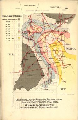
- Abstract:
- Relation of Trenton rock to sea level shown with shading and contour lines. Map showing paths of the geological cross sections depicted in the illustrations ...
- Call Number:
- G4091.C57 1893 .C83
- Caption:
- Imprint: Indpls : lithographed by William B. Burford, [1894] and Imprint: [Indianapolis] : [Indiana, Dept. of Geology and Natural Resources], [1894]
- Physical Description:
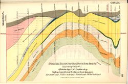
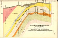
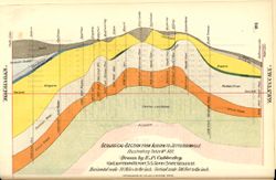
- Scale: Scale not given. and Dimensions: 15 x 23 cm
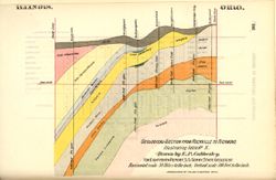
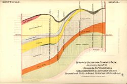
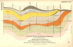
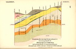
- Alternate Identifier:
- Title Control Number: a18224941 and Alternate ID: 390726IP
- Persistent URL:
- https://purl.dlib.indiana.edu/iudl/images/VAC3073/VAC3073-M-01555
- Provenance:
- 18th Annual Report (1893) / Indiana. Department of Geology and Natural Resources.
-
- Subject:
- Topical Subject: Mines and mineral resources, Topical Subject: IGS Annual Reports, Geographic Subject: Harrison County (Ind.), Topical Subject: Corydon Capit...
- Creator:
- Collett, John, 1828-1899
- Publisher:
- Indiana. Geological Survey
- Date Created:
- 1879
- Identifier:
- VAC3073-M-01554
- Genre:
- Geological maps
- Geographic Location:
- Coordinates: W0861951 W0855359 N0382520 N0375731
- Related URL:
- Catalog URL: https://iucat.iu.edu/catalog/18363798
- Abstract:
- Prepared for the 10th annual report of Prof. E.T. Cox, State Geologist by John Collett, 1878. Relief shown by hachures. Shows cities and towns, railroads, sp...
- Call Number:
- G4093.H4C5 1878 .C6
- Caption:
- Imprint: [Indianapolis] : [Geological Survey of Indiana], [1879] and Imprint: [Indianapolis] : [Indianapolis Journal Company, State printers], [1879]
- Physical Description:
- Dimensions: on sheet 44 x 36 cm and Scale: Approximately 1:130,000
- Alternate Identifier:
- Alternate ID: 390723IP and Title Control Number: a18363798
- Persistent URL:
- https://purl.dlib.indiana.edu/iudl/images/VAC3073/VAC3073-M-01554
- Provenance:
- 8th, 9th, and 10th Annual Reports (1876, 1877, 1878) / Indiana. Geological Survey.
-
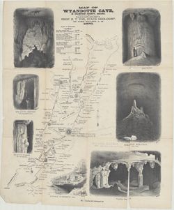
- Subject:
- Topical Subject: Caves, Topical Subject: IGS Annual Reports, Topical Subject: Speleothems, and Geographic Subject: Wyandotte Cave (Ind.)
- Creator:
- Collett, John, 1828-1899
- Publisher:
- Indiana. Geological Survey
- Date Created:
- 1879
- Identifier:
- VAC3073-M-01552
- Genre:
- Drawings, Pictorial works, Tables (Data), and Thematic maps
- Geographic Location:
- Coordinates: W0861746 W0861746 N0381341 N0381341
- Related URL:
- Catalog URL: https://iucat.iu.edu/catalog/18372653
- Abstract:
- Prepared for the 10th Annual Report of Prof. E. T. Cox, State Geologist, by John Collett, A. M. Relief shown by hachures. Includes sketches of some cave feat...
- Call Number:
- G4093.C7C23 1878 .C6
- Caption:
- Imprint: [Indianapolis] : [Indianapolis Journal Company, State printers], [1879] and Imprint: [Indianapolis] : [Geological Survey of Indiana], [1879]
- Physical Description:
- Dimensions: on sheet 54 x 46 cm and Scale: Approximately 1:11,000
- Alternate Identifier:
- Alternate ID: 390723IP and Title Control Number: a18372653
- Persistent URL:
- https://purl.dlib.indiana.edu/iudl/images/VAC3073/VAC3073-M-01552
- Provenance:
- 8th, 9th, and 10th Annual Reports (1876, 1877, 1878) / Indiana. Geological Survey.
-
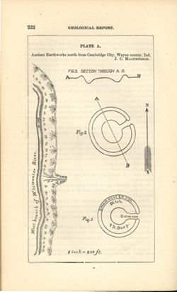
- Subject:
- Geographic Subject: Cambridge City (Ind.), Topical Subject: Henges, and Topical Subject: IGS Annual Reports
- Creator:
- Macpherson, J. C. (John C.)
- Publisher:
- Indiana. Geological Survey
- Date Created:
- 1879
- Identifier:
- VAC3073-M-01551
- Genre:
- Pictorial maps
- Geographic Location:
- Coordinates: W0851016 W0851004 N0395012 N0395001
- Related URL:
- Catalog URL: https://iucat.iu.edu/catalog/18387638
- Abstract:
- At head of title: Plate A. Relief shown by profile and spot heights. Includes pictorial map of west branch of Whitewater River and three figures showing heig...
- Call Number:
- G4094.C15E15 1878 .M33
- Caption:
- Imprint: [Indianapolis] : [Indianapolis Journal Company, State printers], [1879] and Imprint: [Indianapolis] : [Geological Survey of Indiana], [1879]
- Physical Description:
- Dimensions: on sheet 22 x 13 cm and Scale: Approximately 1:2,400. 1 inch = 200 ft.
- Alternate Identifier:
- Alternate ID: 390723IP and Title Control Number: a18387638
- Persistent URL:
- https://purl.dlib.indiana.edu/iudl/images/VAC3073/VAC3073-M-01551
- Provenance:
- 8th, 9th, and 10th Annual Reports (1876, 1877, 1878) / Indiana. Geological Survey.
-
- Subject:
- Geographic Subject: New Garden (Ind. : Township), Topical Subject: Earthworks (Archaeology), and Topical Subject: IGS Annual Reports
- Creator:
- Macpherson, J. C. (John C.)
- Publisher:
- Indiana. Geological Survey
- Date Created:
- 1879
- Identifier:
- VAC3073-M-01550
- Genre:
- Pictorial maps
- Geographic Location:
- Coordinates: W0845400 W0845300 N0395800 N0395700
- Related URL:
- Catalog URL: https://iucat.iu.edu/catalog/18387636
- Abstract:
- At head of title: Plate C. Shows streams, pits, and earthwork [Indiana Adena Square?] with measurements. Detached from: Eighth, ninth, and tenth annual re...
- Call Number:
- G4094.N438 1978 .M33
- Caption:
- Imprint: [Indianapolis] : [Indianapolis Journal Company, State printers], [1879] and Imprint: [Indianapolis] : [Geological Survey of Indiana], [1879]
- Physical Description:
- Dimensions: on sheet 14 x 21 cm and Scale: Approximately 1:6,000. 1 inch = 500 ft.
- Alternate Identifier:
- Alternate ID: 390723IP and Title Control Number: a18387636
- Persistent URL:
- https://purl.dlib.indiana.edu/iudl/images/VAC3073/VAC3073-M-01550
- Provenance:
- 8th, 9th, and 10th Annual Reports (1876, 1877, 1878) / Indiana. Geological Survey.
-
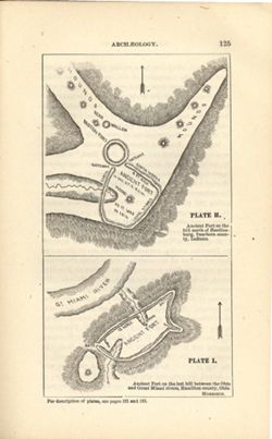
- Subject:
- Topical Subject: IGS Annual Reports, Topical Subject: Mounds, Topical Subject: Fortification, Prehistoric, Topical Subject: Indians of North America, Geograp...
- Creator:
- Morrison, Samuel (Civil engineer)
- Publisher:
- Indiana. Geological Survey
- Date Created:
- 1879
- Identifier:
- VAC3073-M-01548
- Genre:
- Pictorial maps
- Geographic Location:
- Coordinates: W0850758 W0844909 N0391829 N0385607
- Related URL:
- Catalog URL: https://iucat.iu.edu/catalog/18387663
- Abstract:
- At head of first title: Plate H , At head of second title: Plate I. Relief shown by hachures and spot heights. Shows prehistoric forts [Miami Fort and Oberti...
- Call Number:
- QE109 .A2
- Caption:
- Imprint: [Indianapolis] : [Geological Survey of Indiana], [1879] and Imprint: [Indianapolis] : [Indianapolis Journal Company, State printers], [1879]
- Physical Description:
- Dimensions: 22 x 14 cm and Scale: Scale not given.
- Alternate Identifier:
- Title Control Number: a18387663 and Alternate ID: 390723IP
- Persistent URL:
- https://purl.dlib.indiana.edu/iudl/images/VAC3073/VAC3073-M-01548
- Provenance:
- 8th, 9th, and 10th Annual Reports (1876, 1877, 1878) / Indiana. Geological Survey.
-
- Subject:
- Topical Subject: IGS Annual Reports, Topical Subject: Coal mines and mining, Geographic Subject: Crawford County (Ind.), Geographic Subject: Wyandotte Cave (...
- Creator:
- Collett, John, 1828-1899
- Publisher:
- Indiana. Geological Survey
- Date Created:
- 1879
- Identifier:
- VAC3073-M-01546
- Genre:
- Thematic maps
- Geographic Location:
- Coordinates: W0863746 W0861445 N0382324 N0380600
- Related URL:
- Catalog URL: https://iucat.iu.edu/catalog/18349479
- Abstract:
- Prepared for 10th annual report of Prof. E.T. Cox, State Geologist by John Collett, 1878. Relief shown by hachures. Shows cities and towns, railroads, cavern...
- Call Number:
- G4093.C7C5 1878 .C6
- Caption:
- Imprint: [Indianapolis] : [Geological Survey of Indiana], [1879] and Imprint: [Indianapolis] : [Indianapolis Journal Company, State printers], [1879]
- Physical Description:
- Scale: Approximately 1:125,000 and Dimensions: on sheet 39 x 44 cm
- Alternate Identifier:
- Title Control Number: a18349479 and Alternate ID: 390723IP
- Persistent URL:
- https://purl.dlib.indiana.edu/iudl/images/VAC3073/VAC3073-M-01546
- Provenance:
- 8th, 9th, and 10th Annual Reports (1876, 1877, 1878) / Indiana. Geological Survey.
-
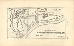
- Subject:
- Geographic Subject: New Garden (Ind. : Township), Topical Subject: Mounds, Topical Subject: Fortification, Prehistoric, Geographic Subject: Hamilton County (...
- Creator:
- Morrison, Samuel (Civil engineer)
- Publisher:
- Indiana. Geological Survey
- Date Created:
- 1879
- Identifier:
- VAC3073-M-01547
- Genre:
- Maps
- Geographic Location:
- Coordinates: W0845228 W0844558 N0390800 N0390448
- Related URL:
- Catalog URL: https://iucat.iu.edu/catalog/18387640
- Abstract:
- At head of title: Plate G. Relief shown by hachures. Shows prehistoric forts, mounds, waterways, and railroads. "The following map and diagrams are redu...
- Call Number:
- G4071.E15 1878 .M67
- Caption:
- Imprint: [Indianapolis] : [Indianapolis Journal Company, State printers], [1879] and Imprint: [Indianapolis] : [Geological Survey of Indiana], [1879]
- Physical Description:
- Scale: Scale approximately 1:55,000 and Dimensions: on sheet 14 x 21 cm
- Alternate Identifier:
- Title Control Number: a18387640 and Alternate ID: 390723IP
- Persistent URL:
- https://purl.dlib.indiana.edu/iudl/images/VAC3073/VAC3073-M-01547
- Provenance:
- 8th, 9th, and 10th Annual Reports (1876, 1877, 1878) / Indiana. Geological Survey.
-
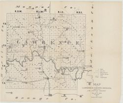
- Subject:
- Topical Subject: Mines and mineral resources, Topical Subject: Caves, Geographic Subject: Lawrence County (Ind.), Topical Subject: Geology, and Topical Subje...
- Creator:
- Collett, John, 1828-1899 and Cox, E. T. (Edward Travers), 1821-1907
- Publisher:
- Indiana. Geological Survey
- Date Created:
- 1874
- Identifier:
- VAC3073-M-01544
- Genre:
- Thematic maps
- Geographic Location:
- Coordinates: W0864107 W0861630 N0385938 N0384112
- Related URL:
- Catalog URL: https://iucat.iu.edu/catalog/18318621
- Abstract:
- Prepared for the 5th Annual Report of Prof. E.T. Cox. 1873. Geology by John Collett. Relief shown by hachures. Shows cities and towns, railroads, mills, cave...
- Call Number:
- G4093.L5C5 1873 .C6
- Caption:
- Imprint: [Indianapolis] : [Sentinel Co., printers], [1874] and Imprint: [Indianapolis] : [Geological Survey of Indiana], [1874]
- Physical Description:
- Scale: Approximately 1:120,000 and Dimensions: on sheet 37 x 44 cm
- Alternate Identifier:
- Title Control Number: a18318621 and Alternate ID: 390723IP
- Persistent URL:
- https://purl.dlib.indiana.edu/iudl/images/VAC3073/VAC3073-M-01544
- Provenance:
- 5th Annual Report (1873) / Indiana. Geological Survey.
-
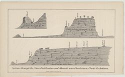
- Subject:
- Topical Subject: Stone walls, Geographic Subject: Clark County (Ind.), Topical Subject: Mounds, and Topical Subject: Fortification
- Publisher:
- Indiana. Geological Survey
- Date Created:
- 1873
- Identifier:
- VAC3073-M-01543
- Genre:
- Geological cross-sections and Pictorial maps
- Geographic Location:
- Coordinates: W0853723 W0853635 N0382605 N0382513
- Related URL:
- Catalog URL: https://iucat.iu.edu/catalog/18318650
- Abstract:
- 3 sections on 1 sheet. Relief shown by profile. Detached from: Geology report. In Fifth annual report of the Geological Survey of Indiana, made in the yea...
- Call Number:
- G4093.C4R4 1873 .S43
- Caption:
- Imprint: [Indianapolis] : [Geological Survey of Indiana], [1874] and Imprint: [Indianapolis] : [Sentinel Co., printers], [1874]
- Physical Description:
- Scale: Scale not given. and Dimensions: on sheet 14 x 22 cm
- Alternate Identifier:
- Title Control Number: a18318650 and Alternate ID: 390723IP
- Persistent URL:
- https://purl.dlib.indiana.edu/iudl/images/VAC3073/VAC3073-M-01543
- Provenance:
- 5th Annual Report (1873) / Indiana. Geological Survey.
-
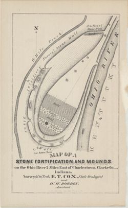
- Subject:
- Geographic Subject: Ohio River, Topical Subject: IGS Annual Reports, Topical Subject: Rivers, Topical Subject: Mounds, Topical Subject: Fortification, Geogra...
- Creator:
- Cox, E. T. (Edward Travers), 1821-1907 and Borden, W. W. (William Wesley), 1823-1906
- Publisher:
- Indiana. Geological Survey
- Date Created:
- 1873
- Identifier:
- VAC3073-M-01542
- Genre:
- Pictorial maps
- Geographic Location:
- Coordinates: W0853723 W0853635 N0382605 N0382513
- Related URL:
- Catalog URL: https://iucat.iu.edu/catalog/18318556
- Abstract:
- Surveyed by Prof. E. T. Cox and W. W. Borden. Pictorial map showing natural and artificial stone walls surrounding fields, timber, and mounds between the Ohi...
- Call Number:
- G4093.C4R4 1873 .C69
- Caption:
- Imprint: Indianapolis : Braden & Burford, Steam Lith., [1873] and Imprint: [Indianapolis] : [Geological Survey of Indiana], [1874]
- Physical Description:
- Dimensions: on sheet 22 x 14 cm and Scale: Scale not given.
- Alternate Identifier:
- Title Control Number: a18318556 and Alternate ID: 390723IP
- Persistent URL:
- https://purl.dlib.indiana.edu/iudl/images/VAC3073/VAC3073-M-01542
- Provenance:
- 5th Annual Report (1873) / Indiana. Geological Survey.
-
- Subject:
- Geographic Subject: North Rhine-Westphalia (Germany), Topical Subject: IGS Annual Reports, and Topical Subject: Mines and mineral resources
- Creator:
- Hartmann, Hugh
- Publisher:
- Indiana. Geological Survey
- Date Created:
- 1873
- Identifier:
- VAC3073-M-01541
- Genre:
- Geological maps
- Geographic Location:
- Coordinates: E0053400 E0095500 N0522700 N0485600
- Related URL:
- Catalog URL: https://iucat.iu.edu/catalog/18422455
- Abstract:
- Other title: Map showing the deposits of ores and coal in Rhineland Prussia and Westphalia. Shows coal beds and ore deposits by period as well as railroads, ...
- Call Number:
- G6361.H1 1873 .H3
- Caption:
- Imprint: [Indianapolis] [Geological Survey of Indiana], [1873]
- Physical Description:
- Scale: Approximately 1:3,352,800 and Dimensions: 18 x 11 cm
- Alternate Identifier:
- Alternate ID: 390723IP and Title Control Number: a18422455
- Persistent URL:
- https://purl.dlib.indiana.edu/iudl/images/VAC3073/VAC3073-M-01541
- Provenance:
- 5th Annual Report (1873) / Indiana. Geological Survey.
-
- Subject:
- Geographic Subject: Bone Bank Site (Ind.), Topical Subject: IGS Annual Reports, Geographic Subject: Posey County (Ind.), Topical Subject: Mississippian cultu...
- Creator:
- Levette, G. M. (Gilbert M.)
- Publisher:
- Indiana. Geological Survey
- Date Created:
- 1874
- Identifier:
- VAC3073-M-01540
- Genre:
- Pictorial maps and Geological cross-sections
- Geographic Location:
- Coordinates: W0880126 W0880126 N0374955 N0374955
- Related URL:
- Catalog URL: https://iucat.iu.edu/catalog/18308000
- Abstract:
- 1 map and 1 section on 1 sheet. Surveyed and drawn by G.M. Levette Nov. 1873. Shows the "probable western outline of the 'Bone Bank' within the ...
- Call Number:
- G4093.P6E15 1873 .L48
- Caption:
- Imprint: Inds. : Braden & Burford Steam Lith. [1874] and Imprint: [Indianapolis] : [Geological Survey of Indiana], [1874]
- Physical Description:
- Scale: Not drawn to scale. and Dimensions: on sheet 20 x 12 cm
- Alternate Identifier:
- Alternate ID: 390723IP and Title Control Number: a18308000
- Persistent URL:
- https://purl.dlib.indiana.edu/iudl/images/VAC3073/VAC3073-M-01540
- Provenance:
- 5th Annual Report (1873) / Indiana. Geological Survey.
-

- Subject:
- Geographic Subject: Muncie (Ind.)
- Creator:
- Hefel, Toney C.
- Publisher:
- E.P. Noll & Co.
- Date Created:
- 1891
- Identifier:
- VAC3073-M-01538
- Genre:
- Thematic maps
- Related URL:
- Catalog URL: new.iucat.iu.edu/catalog/2789504
- Abstract:
- Includes advertisements for city businesses. Includes "Fire alarm boxes" locations.
- Call Number:
- G4094.M9 1891 .H44
- Caption:
- Imprint: Philadelphia [Pa.] : 1891.
- Physical Description:
- Dimensions: 107 x 137 cm, on sheet 128 x 166 cm and Scale: Approximately 1:4,800. 400 feet to 1 inch
- Persistent URL:
- https://purl.dlib.indiana.edu/iudl/images/VAC3073/VAC3073-M-01538
-
- Subject:
- Geographic Subject: Wells County (Ind.), Topical Subject: IGS Annual Reports, and Topical Subject: Soils
- Creator:
- United States. Bureau of Soils, Tharp, W. E. (William Edgar), and Wiley, W. E. (William Emmett), 1894-1967
- Publisher:
- Indiana. Department of Geology and Natural Resources
- Date Created:
- 1916
- Identifier:
- VAC3073-M-01537
- Genre:
- Thematic maps
- Geographic Location:
- Coordinates: W0852656 W0850406 N0405504 N0403400
- Related URL:
- Catalog URL: https://iucat.iu.edu/catalog/16138560
- Abstract:
- "Field Operations, Bureau of Soils, 1915." Detached from: Soil survey of Wells County / W. E. Tharp and W. E. Wiley. In Fortieth annual report o...
- Call Number:
- G4093.W7J3 1915 .T49
- Caption:
- Imprint: [Fort Wayne]: [Fort Wayne Printing Company], [1916] and Imprint: [Indianapolis] : State of Indiana, Department of Geology, [1916]
- Physical Description:
- Dimensions: 58 x 48 cm and Scale: 1:63,360. 1 in. = 1 mile
- Alternate Identifier:
- Title Control Number: a16138560 and Alternate ID: 390726IP
- Persistent URL:
- https://purl.dlib.indiana.edu/iudl/images/VAC3073/VAC3073-M-01537
- Provenance:
- 40th Annual Report (1915) / Indiana. Department of Geology and Natural Resources.
-
- Subject:
- Geographic Subject: Indiana and Topical Subject: IGS Annual Reports
- Creator:
- Hesler, R. S.
- Publisher:
- Indiana. Department of Geology and Natural Resources
- Date Created:
- 1913
- Identifier:
- VAC3073-M-01536
- Genre:
- Topographic maps
- Geographic Location:
- Coordinates: W0880500 W0844700 N0414500 N0374600
- Related URL:
- Catalog URL: https://iucat.iu.edu/catalog/18466085
- Abstract:
- Relief shown by choropleth methods. "Note: Data--railroad elevations, Plan--after Leverett." Detached from: Topography of Indiana--Map / Edward ...
- Call Number:
- G4091.C2 1913 .H4
- Caption:
- Imprint: [Indianapolis] : [Indiana Department of Geology and Natural Resources], [1913]
- Physical Description:
- Dimensions: on sheet 73 x 46 cm and Scale: Scale not given.
- Alternate Identifier:
- Alternate ID: 390726IP and Title Control Number: a18466085
- Persistent URL:
- https://purl.dlib.indiana.edu/iudl/images/VAC3073/VAC3073-M-01536
- Provenance:
- 37th Annual Report (1912) / Indiana. Department of Geology and Natural Resources.
-
- Subject:
- Geographic Subject: Indiana, Northwest, Geographic Subject: Michigan, Geographic Subject: Indiana, Topical Subject: Geology, Geographic Subject: Illinois, To...
- Creator:
- Illinois State Geological Survey, Indiana. Geological Survey, Keller, Stanley J., and Schneider, Allan F. (Allan Frank), 1926-
- Publisher:
- Indiana. Geological Survey
- Date Created:
- 1970
- Identifier:
- VAC3073-M-01535
- Genre:
- Geological cross-sections, Quadrangle maps, and Geological maps
- Geographic Location:
- Coordinates: W0880000 W0860000 N0420000 N0410000
- Related URL:
- Catalog URL: https://iucat.iu.edu/catalog/17017966
- Abstract:
- By Allan F. Schneider and Stanley J. Keller. Transverse Mercator projection. "Indiana Geological Survey in cooperation with Illinois State Geological Su...
- Call Number:
- G4091.C5 1970 .G3
- Caption:
- Imprint: [Bloomington, Ind.] : Indiana Geological Survey, 1970
- Physical Description:
- Scale: 1:250,000 and Dimensions: 44 x 67 cm, on sheet 74 x 106 cm
- Alternate Identifier:
- Title Control Number: a17017966
- Persistent URL:
- https://purl.dlib.indiana.edu/iudl/images/VAC3073/VAC3073-M-01535
- Provenance:
- Indiana. Geological Survey. Regional geologic map , no. 4.
-
- Subject:
- Topical Subject: Geology, Economic, Geographic Subject: Sullivan County (Ind.), Topical Subject: Mines and mineral resources, and Topical Subject: IGS Annual...
- Creator:
- Collett, John, 1828-1899, Levette, G. M. (Gilbert M.), and Cox, E. T. (Edward Travers), 1821-1907
- Publisher:
- Indiana. Geological Survey
- Date Created:
- 1871
- Identifier:
- VAC3073-M-01533
- Genre:
- Geological maps
- Geographic Location:
- Coordinates: W0873941 W0870603 N0392100 N0384802
- Related URL:
- Catalog URL: https://iucat.iu.edu/catalog/18283359
- Abstract:
- Drawn by G.M. Levette, for the second annual report of Prof. E.T. Cox, state geologist , geology by John Collett. "Braden & Burford, Lith., Indianap...
- Call Number:
- QE109 .A2 1870 map Sullivan
- Caption:
- Imprint: Indianapolis, Ind. : Geological Survey of Indiana, [1871]
- Physical Description:
- Scale: Approximately 1:85,000 and Dimensions: on sheet 82 x 64 cm
- Alternate Identifier:
- Alternate ID: 390721IP and Title Control Number: a18283359
- Persistent URL:
- https://purl.dlib.indiana.edu/iudl/images/VAC3073/VAC3073-M-01533
- Provenance:
- 2nd Annual Report (1870) / Indiana. Geological Survey.
-
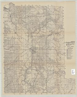
- Subject:
- Geographic Subject: Monroe County (Ind.), Topical Subject: IGS Annual Reports, Topical Subject: Mines and mineral resources, and Topical Subject: Geology
- Creator:
- Shannon, C. W. (Charles William), 1879-1934
- Publisher:
- Indiana. Department of Geology and Natural Resources
- Date Created:
- 1908
- Identifier:
- VAC3073-M-01532
- Genre:
- Thematic maps
- Related URL:
- Catalog URL: https://iucat.iu.edu/catalog/11914890
- Abstract:
- Shows roads, earth and improved, railroads, school houses, and churches. Detached from: Soil survey of Monroe, Brown, Lawrence, Martin, Orange, Washington, ...
- Call Number:
- QE109 .A2 1907 Map p.123 Monroe County
- Caption:
- Imprint: [Indianapolis : 1908].
- Physical Description:
- Dimensions: on sheet 66 x 52 cm and Scale: Approximately 1:63,360
- Persistent URL:
- https://purl.dlib.indiana.edu/iudl/images/VAC3073/VAC3073-M-01532
-
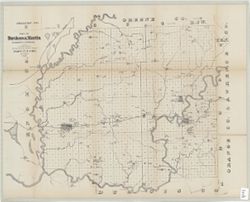
- Subject:
- Topical Subject: Geology, Economic, Geographic Subject: Martin County (Ind.), Geographic Subject: Daviess County (Ind.), Topical Subject: IGS Annual Reports,...
- Creator:
- Collett, John, 1828-1899, Cox, E. T. (Edward Travers), 1821-1907, and Levette, G. M. (Gilbert M.)
- Publisher:
- Indiana. Geological Survey
- Date Created:
- 1871
- Identifier:
- VAC3073-M-01531
- Genre:
- Geological maps
- Geographic Location:
- Coordinates: W0871645 W0863823 N0385617 N0382924
- Related URL:
- Catalog URL: https://iucat.iu.edu/catalog/18282530
- Abstract:
- Drawn by G.M. Levette for the second annual report of Prof. E.T. Cox, state geologist , [geology by John Collett]. Shows worked coal, coal outcrops, iron ore...
- Call Number:
- G4093.D2H1 1870 .L4
- Caption:
- Imprint: Indianapolis, Ind. : Geological Survey of Indiana, [1871]
- Physical Description:
- Scale: Approximately 1:85,000 and Dimensions: on sheet 63 x 79 cm
- Alternate Identifier:
- Title Control Number: a18282530 and Alternate ID: 390721IP
- Persistent URL:
- https://purl.dlib.indiana.edu/iudl/images/VAC3073/VAC3073-M-01531
- Provenance:
- 2nd Annual Report (1870) / Indiana. Geological Survey.
-
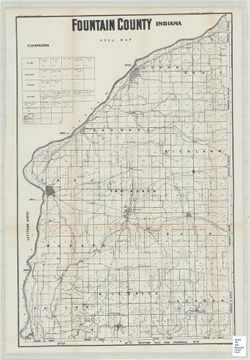
- Subject:
- Topical Subject: Mines and mineral resources, Topical Subject: Geology, Geographic Subject: Fountain County (Ind.), and Topical Subject: IGS Annual Reports
- Creator:
- Indiana. Department of Geology and Natural Resources
- Date Created:
- 1916
- Identifier:
- VAC3073-M-01529
- Genre:
- Thematic maps
- Related URL:
- Catalog URL: https://iucat.iu.edu/catalog/4022273
- Call Number:
- QE109 .A2 1915
- Persistent URL:
- https://purl.dlib.indiana.edu/iudl/images/VAC3073/VAC3073-M-01529
-
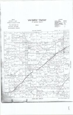
- Subject:
- Topical Subject: Real property, Topical Subject: Landowners, and Geographic Subject: Van Buren (Monroe County, Ind. : Township)
- Creator:
- Stevens, Katherine (Mapmaker)
- Publisher:
- Stevens, Katherine (Mapmaker)
- Date Created:
- 1939
- Identifier:
- VAC3073-M-01526
- Genre:
- Cadastral maps
- Geographic Location:
- Coordinates: W0864055 W0863423 N0390953 N0390446
- Related URL:
- Catalog URL: https://iucat.iu.edu/catalog/18408348
- Abstract:
- Made by Katherine Stevens. Title in lower right corner: Plat #7, Van Buren Twp. Shows roads, creeks, churches, cemeteries, schools, and owner names with acre...
- Call Number:
- G4093.M7G46 1939 .S74 Van Buren
- Caption:
- Imprint: Bloomington, Indiana : Katherine Stevens, [1939]
- Physical Description:
- Dimensions: on sheet 92 x 59 cm and Scale: Approximately 1:18,000. 1,500 feet = 1 inch
- Alternate Identifier:
- Title Control Number: a18408348
- Persistent URL:
- https://purl.dlib.indiana.edu/iudl/images/VAC3073/VAC3073-M-01526
- Provenance:
- Katherine Stevens. Township maps of Monroe County, Indiana, [1939]
-
- Subject:
- Topical Subject: Real property, Geographic Subject: Washington (Monroe County, Ind. : Township), and Topical Subject: Landowners
- Creator:
- Stevens, Katherine (Mapmaker)
- Publisher:
- Stevens, Katherine (Mapmaker)
- Date Created:
- 1939
- Identifier:
- VAC3073-M-01525
- Genre:
- Cadastral maps
- Geographic Location:
- Coordinates: W0863534 W0862752 N0392013 N0391503
- Related URL:
- Catalog URL: https://iucat.iu.edu/catalog/18408369
- Abstract:
- Made by Katherine Stevens. Title in lower right corner: Plat #2, Washington Twp. Shows roads, creeks, churches, cemeteries, schools, and owner names with acr...
- Call Number:
- G4093.M7G46 1939 .S74 Washington
- Caption:
- Imprint: Bloomington, Indiana : Katherine Stevens, [1939]
- Physical Description:
- Scale: Approximately 1:18,000. 1,500 feet = 1 inch and Dimensions: on sheet 92 x 59 cm
- Alternate Identifier:
- Title Control Number: a18408369
- Persistent URL:
- https://purl.dlib.indiana.edu/iudl/images/VAC3073/VAC3073-M-01525
- Provenance:
- Katherine Stevens. Township maps of Monroe County, Indiana, [1939]
-
- Subject:
- Geographic Subject: Indian Creek (Monroe County, Ind. : Township), Topical Subject: Landowners, and Topical Subject: Real property
- Creator:
- Stevens, Katherine (Mapmaker)
- Publisher:
- Stevens, Katherine (Mapmaker)
- Date Created:
- 1939
- Identifier:
- VAC3073-M-01523
- Genre:
- Cadastral maps
- Geographic Location:
- Coordinates: W0864107 W0863423 N0390445 N0385938
- Related URL:
- Catalog URL: https://iucat.iu.edu/catalog/18409333
- Abstract:
- Made by Katherine Stevens. Title in lower right corner: Plat #10, Indian Creek Twp. Shows roads, creeks, railroads, churches, cemeteries, schools, and owner ...
- Call Number:
- G4093.M7G46 1939 .S74 Indian Creek
- Caption:
- Imprint: Bloomington, Indiana : Katherine Stevens, [1939]
- Physical Description:
- Dimensions: on sheet 92 x 59 cm and Scale: Approximately 1:18,000. 1,500 feet = 1 inch
- Alternate Identifier:
- Title Control Number: a18409333
- Persistent URL:
- https://purl.dlib.indiana.edu/iudl/images/VAC3073/VAC3073-M-01523
- Provenance:
- Katherine Stevens. Township maps of Monroe County, Indiana, [1939]
-
- Subject:
- Topical Subject: Real property, Topical Subject: Landowners, and Geographic Subject: Bloomington (Monroe County, Ind. : Township)
- Creator:
- Stevens, Katherine (Mapmaker)
- Publisher:
- Stevens, Katherine (Mapmaker)
- Date Created:
- 1939
- Identifier:
- VAC3073-M-01524
- Genre:
- Cadastral maps
- Geographic Location:
- Coordinates: W0863425 W0862735 N0391636 N0390950
- Related URL:
- Catalog URL: https://iucat.iu.edu/catalog/18408240
- Abstract:
- Made by Katherine Stevens. Title in lower right corner: Plat #5, Bloomington Twp. Shows roads, creeks, railroads, churches, cemeteries, schools, and owner na...
- Call Number:
- G4093.M7G46 1939 .S74 Bloomington
- Caption:
- Imprint: Bloomington, Indiana : Katherine Stevens, [1939]
- Physical Description:
- Dimensions: on sheet 92 x 59 cm and Scale: Approximately 1:18,000. 1,500 feet = 1 inch
- Alternate Identifier:
- Title Control Number: a18408240
- Persistent URL:
- https://purl.dlib.indiana.edu/iudl/images/VAC3073/VAC3073-M-01524
- Provenance:
- Katherine Stevens. Township maps of Monroe County, Indiana, [1939]
-
- Subject:
- Geographic Subject: Benton (Monroe County, Ind. : Township), Topical Subject: Real property, and Topical Subject: Landowners
- Creator:
- Stevens, Katherine (Mapmaker)
- Publisher:
- Stevens, Katherine (Mapmaker)
- Date Created:
- 1939
- Identifier:
- VAC3073-M-01522
- Genre:
- Cadastral maps
- Geographic Location:
- Coordinates: W0862745 W0862213 N0392024 N0391624
- Related URL:
- Catalog URL: https://iucat.iu.edu/catalog/18409337
- Abstract:
- Made by Katherine Stevens. Title in lower right corner: Plat #6, Benton Twp. Shows roads, creeks, railroads, churches, cemeteries, schools, and owner names w...
- Call Number:
- G4093.M7G46 1939 .S74 Benton
- Caption:
- Imprint: Bloomington, Indiana : Katherine Stevens, [1939]
- Physical Description:
- Dimensions: on sheet 92 x 59 cm and Scale: Approximately 1:18,000. 1,500 feet = 1 inch
- Alternate Identifier:
- Title Control Number: a18409337
- Persistent URL:
- https://purl.dlib.indiana.edu/iudl/images/VAC3073/VAC3073-M-01522
- Provenance:
- Katherine Stevens. Township maps of Monroe County, Indiana, [1939]
-
- Subject:
- Geographic Subject: Perry (Monroe County, Ind. : Township), Topical Subject: Real property, and Topical Subject: Landowners
- Creator:
- Stevens, Katherine (Mapmaker)
- Publisher:
- Stevens, Katherine (Mapmaker)
- Date Created:
- 1939
- Identifier:
- VAC3073-M-01521
- Genre:
- Cadastral maps
- Geographic Location:
- Coordinates: W0863423 W0862741 N0390952 N0390531
- Related URL:
- Catalog URL: https://iucat.iu.edu/catalog/18409336
- Abstract:
- Made by Katherine Stevens. Title in lower right corner: Plat #8, Perry Twp. Shows roads, creeks, railroads, churches, cemeteries, schools, and owner names wi...
- Call Number:
- G4093.M7G46 1939 .S74 Perry
- Caption:
- Imprint: Bloomington, Indiana : Katherine Stevens, [1939]
- Physical Description:
- Scale: Approximately 1:18,000. 1,500 feet = 1 inch and Dimensions: on sheet 92 x 59 cm
- Alternate Identifier:
- Title Control Number: a18409336
- Persistent URL:
- https://purl.dlib.indiana.edu/iudl/images/VAC3073/VAC3073-M-01521
- Provenance:
- Katherine Stevens. Township maps of Monroe County, Indiana, [1939]
-
- Subject:
- Topical Subject: Real property, Topical Subject: Landowners, and Geographic Subject: Bean Blossom (Monroe County, Ind. : Township)
- Creator:
- Stevens, Katherine (Mapmaker)
- Publisher:
- Stevens, Katherine (Mapmaker)
- Date Created:
- 1939
- Identifier:
- VAC3073-M-01520
- Genre:
- Cadastral maps
- Geographic Location:
- Coordinates: W0864107 W0863429 N0392125 N0391505
- Related URL:
- Catalog URL: https://iucat.iu.edu/catalog/18408228
- Abstract:
- Made by Katherine Stevens. Title in lower right corner: Plat #1, Bean Blossom Twp. Shows roads, creeks, railroads, churches, cemeteries, schools, and owner n...
- Call Number:
- G4093.M7G46 1939 .S74 Bean Blossom
- Caption:
- Imprint: Bloomington, Indiana : Katherine Stevens, [1939]
- Physical Description:
- Scale: Approximately 1:18,000. 1,500 feet = 1 inch and Dimensions: on sheet 92 x 59 cm
- Alternate Identifier:
- Title Control Number: a18408228
- Persistent URL:
- https://purl.dlib.indiana.edu/iudl/images/VAC3073/VAC3073-M-01520
- Provenance:
- Katherine Stevens. Township maps of Monroe County, Indiana, [1939]
-
- Subject:
- Topical Subject: Real property, Topical Subject: Landowners, and Geographic Subject: Salt Creek (Monroe County, Ind. : Township)
- Creator:
- Stevens, Katherine (Mapmaker)
- Publisher:
- Stevens, Katherine (Mapmaker)
- Date Created:
- 1939
- Identifier:
- VAC3073-M-01519
- Genre:
- Cadastral maps
- Geographic Location:
- Coordinates: W0862738 W0862209 N0390953 N0390440
- Related URL:
- Catalog URL: https://iucat.iu.edu/catalog/18408344
- Abstract:
- Made by Katherine Stevens. Title in lower right corner: Plat #9, Salt Creek Twp. Shows roads, creeks, churches, cemeteries, schools, and owner names with acr...
- Call Number:
- G4093.M7G46 1939 .S74 Salt Creek
- Caption:
- Imprint: Bloomington, Indiana : Katherine Stevens, [1939]
- Physical Description:
- Scale: 1:18,000. 1,500 feet = 1 inch and Dimensions: on sheet 92 x 59 cm
- Alternate Identifier:
- Title Control Number: a18408344
- Persistent URL:
- https://purl.dlib.indiana.edu/iudl/images/VAC3073/VAC3073-M-01519
- Provenance:
- Katherine Stevens. Township maps of Monroe County, Indiana, [1939]
-
- Subject:
- Geographic Subject: Richland (Monroe County, Ind. : Township), Topical Subject: Real property, and Topical Subject: Landowners
- Creator:
- Stevens, Katherine (Mapmaker)
- Publisher:
- Stevens, Katherine (Mapmaker)
- Date Created:
- 1939
- Identifier:
- VAC3073-M-01518
- Genre:
- Cadastral maps
- Geographic Location:
- Coordinates: W0864102 W0863423 N0391509 N0390951
- Related URL:
- Catalog URL: https://iucat.iu.edu/catalog/18409340
- Abstract:
- Made by Katherine Stevens. Title in lower right corner: Plat #4, Richland Twp. Shows roads, creeks, railroads, churches, cemeteries, schools, and owner names...
- Call Number:
- G4093.M7G46 1939 .S74 Richland
- Caption:
- Imprint: Bloomington, Indiana : Katherine Stevens, [1939]
- Physical Description:
- Dimensions: on sheet 92 x 59 cm and Scale: Approximately 1:18,000. 1,500 feet = 1 inch
- Alternate Identifier:
- Title Control Number: a18409340
- Persistent URL:
- https://purl.dlib.indiana.edu/iudl/images/VAC3073/VAC3073-M-01518
- Provenance:
- Katherine Stevens. Township maps of Monroe County, Indiana, [1939]
-
- Subject:
- Topical Subject: Landowners, Geographic Subject: Clear Creek (Monroe County, Ind. : Township), and Topical Subject: Real property
- Creator:
- Stevens, Katherine (Mapmaker)
- Publisher:
- Stevens, Katherine (Mapmaker)
- Date Created:
- 1939
- Identifier:
- VAC3073-M-01517
- Genre:
- Cadastral maps
- Geographic Location:
- Coordinates: W0863409 W0862740 N0390438 N0385938
- Related URL:
- Catalog URL: https://iucat.iu.edu/catalog/18409339
- Abstract:
- Made by Katherine Stevens. Title in lower right corner: Plat #11, Clear Creek Twp. Shows roads, creeks, railroads, churches, cemeteries, schools, and owner n...
- Call Number:
- G4093.M7G46 1939 .S74 Clear Creek
- Caption:
- Imprint: Bloomington, Indiana : Katherine Stevens, [1939]
- Physical Description:
- Scale: 1:18,000. 1,500 feet = 1 inch and Dimensions: on sheet 92 x 59 cm
- Alternate Identifier:
- Title Control Number: a18409339
- Persistent URL:
- https://purl.dlib.indiana.edu/iudl/images/VAC3073/VAC3073-M-01517
- Provenance:
- Katherine Stevens. Township maps of Monroe County, Indiana, [1939]
-
- Subject:
- Geographic Subject: Polk (Monroe County, Ind. : Township), Topical Subject: Landowners, and Topical Subject: Real property
- Creator:
- Stevens, Katherine (Mapmaker)
- Publisher:
- Stevens, Katherine (Mapmaker)
- Date Created:
- 1939
- Identifier:
- VAC3073-M-01516
- Genre:
- Cadastral maps
- Geographic Location:
- Coordinates: W0862741 W0861901 N0390447 N0385936
- Related URL:
- Catalog URL: https://iucat.iu.edu/catalog/18408242
- Abstract:
- Made by Katherine Stevens. Title in lower right corner: Plat #12, Polk Twp. Shows roads, creeks, churches, cemeteries, schools, and owner names with acreage....
- Call Number:
- G4093.M7G46 1939 .S74 Polk
- Caption:
- Imprint: Bloomington, Indiana : Katherine Stevens, [1939]
- Physical Description:
- Scale: 1:18,000. 1,500 feet = 1 inch and Dimensions: on sheet 92 x 59 cm
- Alternate Identifier:
- Title Control Number: a18408242
- Persistent URL:
- https://purl.dlib.indiana.edu/iudl/images/VAC3073/VAC3073-M-01516
- Provenance:
- Katherine Stevens. Township maps of Monroe County, Indiana, [1939]
-
- Subject:
- Topical Subject: Real property, Geographic Subject: Marion (Monroe County, Ind. : Township), Geographic Subject: Benton (Monroe County, Ind. : Township), and...
- Creator:
- Stevens, Katherine (Mapmaker)
- Publisher:
- Stevens, Katherine (Mapmaker)
- Date Created:
- 1939
- Identifier:
- VAC3073-M-01514
- Genre:
- Cadastral maps
- Geographic Location:
- Coordinates: W0862748 W0862250 N0392024 N0391624
- Related URL:
- Catalog URL: https://iucat.iu.edu/catalog/18409341
- Abstract:
- Made by Katherine Stevens. Title in lower right corner: Plat #3, Marion Twp. Shows roads, creeks, churches, cemeteries, schools, and owner names with acreage...
- Call Number:
- G4093.M7G46 1939 .S74 Marion
- Caption:
- Imprint: Bloomington, Indiana : Katherine Stevens, [1939]
- Physical Description:
- Scale: Approximately 1:18,000. 1,500 feet = 1 inch and Dimensions: on sheet 92 x 59 cm
- Alternate Identifier:
- Title Control Number: a18409341
- Persistent URL:
- https://purl.dlib.indiana.edu/iudl/images/VAC3073/VAC3073-M-01514
- Provenance:
- Katherine Stevens. Township maps of Monroe County, Indiana, [1939]
-
- Subject:
- Topical Subject: Soils and Geographic Subject: Starke County (Ind.)
- Creator:
- Grimes, E. J. (Earl Jerome)
- Publisher:
- Indiana. Department of Geology
- Date Created:
- 1916
- Identifier:
- VAC3073-M-01512
- Genre:
- Thematic maps
- Geographic Location:
- Coordinates: W0865548 W0862758 N0412558 N0411016
- Related URL:
- Catalog URL: https://iucat.iu.edu/catalog/16144189
- Abstract:
- Detached from: Soil survey of Starke County, Indiana / E.J. Grimes, Wendell Barrett, and T.M. Bushnell. In 40th Annual report of Department of Geology and Na...
- Call Number:
- G4093.S6J3 1915 .G76
- Caption:
- Imprint: [Indianapolis] : State of Indiana, Department of Geology, [1916]
- Physical Description:
- Scale: 1:63,360
- Persistent URL:
- https://purl.dlib.indiana.edu/iudl/images/VAC3073/VAC3073-M-01512
- Provenance:
- 40th Annual Report (1915) / Indiana. Department of Geology and Natural Resources.
-
- Subject:
- Topical Subject: Soils and Geographic Subject: Grant County (Ind.)
- Creator:
- Hertenstein, Earl, Hurst, Lewis A. (Lewis Alexander), 1874-, Middleton, Philip (Soil surveyor), Watkins, W. I. (William Isaac), 1888-1973, Tharp, W. E. (Will...
- Publisher:
- Indiana. Department of Geology and Natural Resources
- Date Created:
- 1916
- Identifier:
- VAC3073-M-01510
- Genre:
- Thematic maps
- Geographic Location:
- Coordinates: W0855153 W0852639 N0403913 N0402242
- Related URL:
- Catalog URL: https://iucat.iu.edu/catalog/16142796
- Abstract:
- "Field Operations Bureau of Soils, 1915"--Lower margin. Detached from: Soil survey of Grant County, Indiana / L.A. Hurst [and others]. In 40th A...
- Call Number:
- G4093.G6J3 1915 .H88
- Caption:
- Imprint: [Indianapolis] : Indiana Department of Geology, [1916] and Imprint: [Fort Wayne] : [Fort Wayne Printing Company], [1916]
- Physical Description:
- Scale: Approximately 1:63,360. 1 in. = 1 mile and Dimensions: 46 x 53 cm
- Alternate Identifier:
- Title Control Number: a16142796 and Alternate ID: 390726IP
- Persistent URL:
- https://purl.dlib.indiana.edu/iudl/images/VAC3073/VAC3073-M-01510
- Provenance:
- 40th Annual Report (1915) / Indiana. Department of Geology and Natural Resources.
-
![Indiana-Illinois, Vincennes quadrangle : topography [1944 printing without vegetation]](https://iiif.uits.iu.edu/iiif/2/5425mf004%2Ffiles%2Fed25173c-f2ac-49e5-986c-99cf4220f9c3/full/250,/0/default.jpg)
- Subject:
- Geographic Subject: Gibson County (Ind.), Geographic Subject: Wabash County (Ill.), Geographic Subject: Lawrence County (Ill.), and Geographic Subject: Knox ...
- Creator:
- Marshall, R. B. (Robert Bradford), 1867-1949, Geological Survey (U.S.), Tweedy, Frank, 1854-1937, United States. Army. Corps of Engineers, Illinois State Geo...
- Publisher:
- Geological Survey (U.S.)
- Date Created:
- 1944
- Identifier:
- VAC3073-M-01508
- Genre:
- Topographic maps, 15 minute topographic maps, and Quadrangle maps
- Geographic Location:
- Coordinates: W0874500 W0873000 N0384500 N0383000
- Related URL:
- Catalog URL: https://iucat.iu.edu/catalog/18415517
- Abstract:
- R.B. Marshall, chief geographer , W.H. Herron, geographer in charge , topography by Frank Tweedy, C.L. Sadler, Chas. Hartmann, Jr., L.L. Lee, W.S. Gehres, an...
- Call Number:
- G4090 s62 .G4 Vincennes 1944
- Caption:
- Imprint: [Washington, D.C.] : U.S. Geological Survey, 1944.
- Physical Description:
- Scale: 1:62,500 and Dimensions: 45 x 42 cm or smaller
- Alternate Identifier:
- Title Control Number: a18415517
- Persistent URL:
- https://purl.dlib.indiana.edu/iudl/images/VAC3073/VAC3073-M-01508
- Provenance:
- Part of Geological Survey (U.S.). Indiana 1:62,500.
-
![Vandalia quadrangle, Michigan-Indiana : 15 minute series (topographic) [1959 reprint without vegetation]](https://iiif.uits.iu.edu/iiif/2/9593vz28s%2Ffiles%2F4f6d2df8-a9b9-45fc-993f-1949cda1ffbb/full/250,/0/default.jpg)
- Subject:
- Geographic Subject: Saint Joseph County (Mich.), Geographic Subject: Elkhart County (Ind.), and Geographic Subject: Cass County (Mich.)
- Creator:
- Geological Survey (U.S.) and Michigan. State Highway Department
- Publisher:
- Geological Survey (U.S.)
- Date Created:
- 1959
- Identifier:
- VAC3073-M-01506
- Genre:
- 15 minute topographic maps, Quadrangle maps, and Topographic maps
- Geographic Location:
- Coordinates: W0860000 W0854500 N0420000 N0414500
- Related URL:
- Catalog URL: https://iucat.iu.edu/catalog/18415471
- Abstract:
- Mapped, edited, and published by the Geological Survey. Filing title: Vandalia, Mich.-Ind. Standard map series designation: AMS (Series) V762 3867 IV. [Editi...
- Call Number:
- G4090 s62 .G4 Vandalia 1948
- Caption:
- Imprint: Washington, D.C. : Interior--U.S. Geological Survey, [1959]
- Physical Description:
- Scale: 1:62,500 and Dimensions: 45 x 42 cm or smaller
- Alternate Identifier:
- Title Control Number: a18415471
- Persistent URL:
- https://purl.dlib.indiana.edu/iudl/images/VAC3073/VAC3073-M-01506
- Provenance:
- Part of Geological Survey (U.S.). Indiana 1:62,500.
-
![Vandalia quadrangle, Michigan-Indiana : 15 minute series (topographic) [1973 reprint with vegetation]](https://iiif.uits.iu.edu/iiif/2/0g355j55q%2Ffiles%2F59353208-0771-4acc-8e57-7c989a623800/full/250,/0/default.jpg)
- Subject:
- Topical Subject: Vegetation mapping, Geographic Subject: Saint Joseph County (Mich.), Geographic Subject: Cass County (Mich.), and Geographic Subject: Elkhar...
- Creator:
- Michigan. State Highway Department and Geological Survey (U.S.)
- Publisher:
- Geological Survey (U.S.)
- Date Created:
- 1973
- Identifier:
- VAC3073-M-01507
- Genre:
- 15 minute topographic maps, Quadrangle maps, and Topographic maps
- Geographic Location:
- Coordinates: W0860000 W0854500 N0420000 N0414500
- Related URL:
- Catalog URL: https://iucat.iu.edu/catalog/18415471
- Abstract:
- Mapped, edited, and published by the Geological Survey. Filing title: Vandalia, Mich.-Ind. Standard map series designation: AMS (Series) V762 3867 IV. [Editi...
- Call Number:
- G4090 s62 .G4 Vandalia 1948 V
- Caption:
- Imprint: Washington, D.C. : Interior--U.S. Geological Survey, 1973
- Physical Description:
- Scale: 1:62,500 and Dimensions: 45 x 42 cm or smaller
- Alternate Identifier:
- Title Control Number: a18415471
- Persistent URL:
- https://purl.dlib.indiana.edu/iudl/images/VAC3073/VAC3073-M-01507
- Provenance:
- Part of Geological Survey (U.S.). Indiana 1:62,500.
-
![Indiana Haubstadt quadrangle [1935 reprint]](https://iiif.uits.iu.edu/iiif/2/1544cr71r%2Ffiles%2F5aabf650-fa83-48d4-bdcd-7579f3c6501a/full/250,/0/default.jpg)
- Subject:
- Geographic Subject: Posey County (Ind.), Geographic Subject: Gibson County (Ind.), and Geographic Subject: Vanderburgh County (Ind.)
- Creator:
- Geological Survey (U.S.)
- Publisher:
- Geological Survey (U.S.)
- Date Created:
- 1903
- Identifier:
- VAC3073-M-01505
- Genre:
- 15 minute topographic maps, Topographic maps, and Quadrangle maps
- Geographic Location:
- Coordinates: W0874500 W0873000 N0381500 N0380000
- Related URL:
- Catalog URL: https://iucat.iu.edu/catalog/18408287
- Abstract:
- Engraved Mar. 1903 by U.S.G.S. , Jno. H. Renshawe, geographer in charge , control by Geo. T. Hawkins , topography by Chas. W. Goodlove. Relief shown by conto...
- Call Number:
- G4090 s62 .G4 Haubstadt 1903 R1935
- Caption:
- Imprint: [Washington, D.C.] : U.S. Geological Survey, 1935
- Physical Description:
- Dimensions: 45 x 42 cm or smaller and Scale: 1:62,500
- Alternate Identifier:
- Title Control Number: a18408287
- Persistent URL:
- https://purl.dlib.indiana.edu/iudl/images/VAC3073/VAC3073-M-01505
- Provenance:
- Part of Geological Survey (U.S.). Indiana 1:62,500.
-
![Princeton quadrangle, Indiana-Illinois : 15 minute series (topographic) [1965 reprint with vegetation]](https://iiif.uits.iu.edu/iiif/2/7m01cp47j%2Ffiles%2Fdc826735-24b7-4c3f-9d9b-87ad67efd7e8/full/250,/0/default.jpg)
- Subject:
- Geographic Subject: Gibson County (Ind.), Geographic Subject: Knox County (Ind.), Geographic Subject: Wabash County (Ill.), and Topical Subject: Vegetation m...
- Creator:
- Geological Survey (U.S.), United States. Army Map Service, and Illinois State Geological Survey
- Publisher:
- Geological Survey (U.S.)
- Date Created:
- 1965
- Identifier:
- VAC3073-M-01504
- Genre:
- Topographic maps, 15 minute topographic maps, and Quadrangle maps
- Geographic Location:
- Coordinates: W0874500 W0873000 N0383000 N0381500
- Related URL:
- Catalog URL: https://iucat.iu.edu/catalog/18413928
- Abstract:
- Mapped, edited and published by the Geological Survey , Illinois area mapped in cooperation with State of Illinois Geological Survey. Filing title: Princeton...
- Call Number:
- G4090 s62 .G4 Princeton 1959 V
- Caption:
- Imprint: Washington, D.C. : Interior--U.S. Geological Survey, 1965
- Physical Description:
- Scale: 1:62,500 and Dimensions: 45 x 42 cm or smaller
- Alternate Identifier:
- Title Control Number: a18413928
- Persistent URL:
- https://purl.dlib.indiana.edu/iudl/images/VAC3073/VAC3073-M-01504
- Provenance:
- Part of Geological Survey (U.S.). Indiana 1:62,500.
-
- Subject:
- Geographic Subject: Eel River (Putnam County-Greene County, Ind.), Topical Subject: Navigation, and Topical Subject: Rivers
- Creator:
- United States. Army. Corps of Engineers. Louisville District
- Publisher:
- [United States Engineer Office]
- Date Created:
- 1931
- Identifier:
- VAC3073-M-01502
- Genre:
- Nautical charts
- Geographic Location:
- Coordinates: W0871900 W0865600 N0393000 N0390600
- Related URL:
- Catalog URL: https://iucat.iu.edu/catalog/6468587
- Abstract:
- Surveyed and mapped under the direction of The United States Engineer Office, Louisville, Ky. Relief shown by contours and spot heights. Depths shown by so...
- Call Number:
- G4092.E37 P53 1931 .U5
- Caption:
- Imprint: [Louisville, Ky.] : [United States Engineer Office], [1931]
- Physical Description:
- Scale: 1:12,000 and Dimensions: 93 x 96 cm or smaller
- Persistent URL:
- https://purl.dlib.indiana.edu/iudl/images/VAC3073/VAC3073-M-01502
-
![Princeton quadrangle, Indiana-Illinois : 15 minute series (topographic) [1965 printing without vegetation]](https://iiif.uits.iu.edu/iiif/2/70796d47m%2Ffiles%2Fedc5c6d4-9f41-4b7c-9447-a370bfe906e0/full/250,/0/default.jpg)
- Subject:
- Geographic Subject: Knox County (Ind.), Geographic Subject: Gibson County (Ind.), and Geographic Subject: Wabash County (Ill.)
- Creator:
- Illinois State Geological Survey, United States. Army Map Service, and Geological Survey (U.S.)
- Publisher:
- Geological Survey (U.S.)
- Date Created:
- 1965
- Identifier:
- VAC3073-M-01503
- Genre:
- Quadrangle maps, 15 minute topographic maps, and Topographic maps
- Geographic Location:
- Coordinates: W0874500 W0873000 N0383000 N0381500
- Related URL:
- Catalog URL: https://iucat.iu.edu/catalog/18413928
- Abstract:
- Mapped, edited and published by the Geological Survey , Illinois area mapped in cooperation with State of Illinois Geological Survey. Filing title: Princeton...
- Call Number:
- G4090 s62 .G4 Princeton 1959
- Caption:
- Imprint: Washington, D.C. : Interior--U.S. Geological Survey, 1964.
- Physical Description:
- Dimensions: 45 x 42 cm or smaller and Scale: 1:62,500
- Alternate Identifier:
- Title Control Number: a18413928
- Persistent URL:
- https://purl.dlib.indiana.edu/iudl/images/VAC3073/VAC3073-M-01503
- Provenance:
- Part of Geological Survey (U.S.). Indiana 1:62,500.
-
- Subject:
- Topical Subject: Rivers, Geographic Subject: Ohio River, and Topical Subject: Navigation
- Creator:
- United States. Army. Corps of Engineers
- Publisher:
- U.S. Lake Survey
- Date Created:
- 1911
- Identifier:
- VAC3073-M-01499
- Genre:
- Nautical charts
- Geographic Location:
- Coordinates: W0891200 W0800000 N0404300 N0365700
- Related URL:
- Catalog URL: https://iucat.iu.edu/catalog/10895418
- Abstract:
- Some charts have imprint: Fort Belvoir, Va.: 30th Engineers by reproduction plant, 1943, or Washington, D.C.: Engineer reproduction plant, U.S. Army, 1929.
- Call Number:
- G3707.O5 1911 .U55
- Caption:
- Imprint: Detroit, Michigan : U.S. Lake Survey Office, 1911-1914.
- Physical Description:
- Scale: 1:7,200 and Dimensions: size varies
- Persistent URL:
- https://purl.dlib.indiana.edu/iudl/images/VAC3073/VAC3073-M-01499
-
- Subject:
- Topical Subject: Rivers, Topical Subject: Valleys, Geographic Subject: Wabash River, and Geographic Subject: Wabash River Valley
- Creator:
- Williams & Heintz Co.
- Publisher:
- United States. Army. Corps of Engineers. Louisville District.
- Date Created:
- 1930
- Identifier:
- VAC3073-M-01501
- Genre:
- Nautical charts
- Geographic Location:
- Coordinates: W0880700 W0843300 N0405700 N0374700
- Related URL:
- Catalog URL: https://iucat.iu.edu/catalog/6799690
- Abstract:
- Surveyed and mapped under the direction of the United States engineer officer, Louisville, Ky. 1930. Relief shown by contours and spot heights. Depths sho...
- Call Number:
- G4072.W3 1930 .U5
- Caption:
- Imprint: Washington, D.C. : Williams & Heintz Co., 1931.
- Physical Description:
- Scale: 1:24,000 and Dimensions: 64 x 96 cm, on sheets 72 x 107 cm
- Persistent URL:
- https://purl.dlib.indiana.edu/iudl/images/VAC3073/VAC3073-M-01501
-
- Subject:
- Geographic Subject: Parke County (Ind.) and Topical Subject: Soils
- Creator:
- Orahood, C. H. (Charley Harold), 1882-
- Publisher:
- Indiana. Department of Geology and Natural Resources
- Date Created:
- 1914
- Identifier:
- VAC3073-M-01500
- Genre:
- Thematic maps
- Geographic Location:
- Coordinates: W0872602 W0870034 N0395712 N0393617
- Related URL:
- Catalog URL: https://iucat.iu.edu/catalog/16142627
- Abstract:
- Detached from: Soil Survey of Parke County / Harold Orahood. In 38th Annual report of Department of Geology and Natural Resources, Indiana. "State surve...
- Call Number:
- G4093.P2J3 1913 .O7
- Caption:
- Imprint: [Indianapolis] : [Department of Geology and Natural Resources, Indiana], [1914]
- Physical Description:
- Scale: 1:63,360 and Dimensions: 61 x 55 cm
- Persistent URL:
- https://purl.dlib.indiana.edu/iudl/images/VAC3073/VAC3073-M-01500
- Provenance:
- 38th Annual Report (1913) / Indiana. Department of Geology and Natural Resources.
-
- Subject:
- Topical Subject: Administrative and political divisions and Geographic Subject: Cuyahoga County (Ohio)
- Publisher:
- Whitworth Bros.
- Date Created:
- 1899
- Identifier:
- VAC3073-M-01496
- Genre:
- Maps
- Related URL:
- Catalog URL: new.iucat.iu.edu/catalog/10935244
- Abstract:
- Map of Cuy. Co. in various colors, showing townships and subdivison.
- Call Number:
- G4083.C9 1899 .W45
- Caption:
- Imprint: Cleveland , c1899.
- Physical Description:
- Scale: Approximately 1:55,440. 7/8 in. = 1 mile and Dimensions: 54 x 69 cm, on sheet 60 x 71 cm
- Persistent URL:
- https://purl.dlib.indiana.edu/iudl/images/VAC3073/VAC3073-M-01496
-
- Subject:
- Geographic Subject: Indiana
- Creator:
- Rand McNally and Company
- Publisher:
- Rand McNally and Company
- Date Created:
- 1892
- Identifier:
- VAC3073-M-01495
- Genre:
- Maps
- Geographic Location:
- Coordinates: W0880700 W0844500 N0414500 N0375200
- Related URL:
- Catalog URL: https://iucat.iu.edu/catalog/17017927
- Abstract:
- Shows county boundaries, sections, township names, railroads, and cities and towns. Prime meridian: Washington.
- Call Number:
- G4090 1892 .R36
- Caption:
- Imprint: Chicago : Rand, McNally & Co., [1892]
- Physical Description:
- Scale: 1:506,880 and Dimensions: 95 x 61 cm
- Alternate Identifier:
- Title Control Number: a17017927
- Persistent URL:
- https://purl.dlib.indiana.edu/iudl/images/VAC3073/VAC3073-M-01495
